A s technology progresses, handheld devices have supplanted traditional maps and compass for many of us, and with good reason – these devices are convenient, reliable and utilitarian. So what role remains for our beloved fold-out bushwalking maps? A meaningful one, as it turns out.
Mapping GPS units and smartphone apps have a lot to offer. They can load new maps in seconds, with no shop visit or online order required. In use they directly answer the most important questions: Where am I? Which way now? How far to go? At the end of the day and after the trip they provide a useful record of your travel which can be loaded onto your computer.
Some people question the technology's reliability. Flat batteries, cracked screens, and buggy software are proffered as deal-breakers. But these quibbles are arbitrary - after all, a map and a compass are a more basic technology. A crack in the capsule can quickly disable a compass, and a dunk in a stream renders a map useless.
Instead, physical maps should be seen as a complement to a GPS, or vice versa. Paper maps show us the shape of the land at large in a way not possible on a device screen. By showing us the big picture, maps encourage contemplation and planning. We build our understanding of the country by tracing the interconnection of its ridges, peaks and valleys.
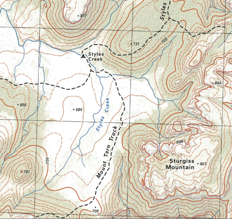
A paper map will often be carefully curated, with close attention paid to everything it shows. Copious aerial imagery and GPS recordings can be aggregated to produce a ground-truth for important trail locations. Lidar, an airborne laser surveying technique, allows landforms and elevation to be presented with superior accuracy.
Forest canopy and vegetation cover can also be extracted from lidar and depicted on paper. These modern techniques contribute to the production of a dependable, accurate and informative map.
In contrast, digital maps are often produced in bulk, with no manual verification. Their most common data sources are government datasets and volunteer-sourced OpenStreetMap. In either case, the data's provenance is uncertain and its quality may be variable. Contours and watercourses on digital maps are often derived from coarse elevation models, or digitised from decades-old maps, leading to noticeable deviations from the actual terrain. Vegetation layers are usually an afterthought, if they're included at all.