High Times in the High Country
TextDamian McDermott
PhotosDamian McDermott and Chris Byrne
Pryors Hut


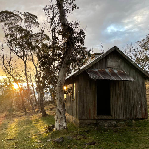
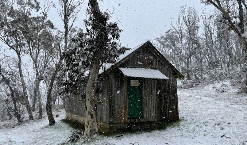
“Will there be snow?” My ten-year-old daughter Mary excitedly asked as we look up a picture of Pryors Hut, a rustic timber mountain hut surrounded by gum trees and a blanket of white snow. I tell Mary it’s possible, without trying to get her hopes up. But I can tell she has interpreted it as “there will definitely be snow”. Pryors Hut is situated high up in the Brindabella Ranges at an elevation of 1650 metres and is no stranger to snow, but it’s also late September and this week's forecast is looking more wet than snowy, with up to 20 mm of rain expected, so we will be lucky to see snow.
26 | Bushwalk February 2023
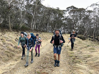
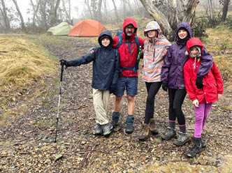
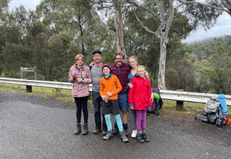
Our group includes myself, my two kids Mary (10) and Daisy (13), our friend Crazy Chris and his kids Rory (12) and Ava (15). We’ve been bushwalking together for years as the “Crazy Danger Crew” and the kids are primed for a real mountain adventure. It’s the spring school holidays and our plan is to spend three days in the “Brindies". Walking up the notoriously steep Stockyard Spur to camp at Pryors Hut. We’ll then take a day trip up Mount Gingera (1865 metres) and walk back down Stockyard Spur on day three.
Day 1: Stockyard Spur To Pryors Hut, 9 km
The trackhead for Stockyard Spur begins at Corin Dam (elevation 950 metres). It’s a 45 minute scenic drive from our accommodation at “Danger Nanna’s” house in Kambah. We drive all the way to the end of Corin Road which crosses over the spillway/dam wall. There’s a small car park and a pit toilet, there are also beautiful views south towards the mountains and north to the Cotter River below.
We’re packed and walking by 11 am and the track is easy to find. From the end of the car park we pass the decommissioned amenities block and Namadgi signage and follow the track towards Stockyard Spur. The ascent is steep, gaining over 500 metres in the first 2.5 kilometres. But we aren’t in a hurry and we have sweets and treats ready for emergency
The Crazy Danger Crew: Chris, Ava, Rory, Mary, Damian and Daisy


Helipad
27
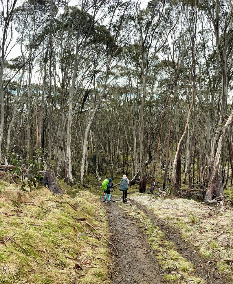
deployment. The track is well built with stairs and switchbacks and we stop multiple times for breaks. There are no tears or meltdowns like our climb up Ironmonger Hill last spring. The kids are all a year older which helps and they carry their own packs the whole way up. After nearly two and a half hours we hit the “helipad” (elevation 1550 metres) a flat clearing that marks the end of the climb and the beginning of the high country.
We still have about a five kilometre walk to Pryors Hut, but after the helipad the walk becomes a gentle stroll to the highest point at about 1650 metres. The scenery is beautiful with eucalypt forests, alpine grasses, granite tors and views towards the mountains. We haven’t seen any snow, but the kids don’t seem to mind. Eventually we intersect with Mount Franklin Road and follow it south-west for about a kilometre towards Pryors Hut.
The hut appears in a clearing just off the road, a welcome sight after almost five hours of walking. We set up our tents, collect water, gather firewood and prepare for a relaxing evening by the fire.
Pryors HutPryor’s hut was built in the early 1950s as temporary accommodation for the workers at the alpine botanic garden. The garden was commissioned by Lindsay Pryor - the ACT's

Afternoon highest point 1650 metres

Stockyard Spur

Mount Franklin Road
28 | Bushwalk February 2023


Bushwalk.com notes and maps on webpage, GPX and PDF
This map is © Bushwalk.com and is created using data © OpenStreetMap contributors
Mount Gingera
Road, four-wheel drive track, walking track (treed)
Main track, side trip, alternate route
Cliff, major contour line, minor contour line (20 metre interval)
Lake, river, waterfall or creek


0 1 2 3 km
Start of the walk
Hut
Campsite
Parking
Toilet


29
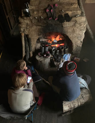
Superintendant of Parks and Gardens at the time. Pryor’s dream never saw completion but his legacy lives on in the remnant exotic pine grove beside the hut, a stunning site now after seventy years of growth. Pryors Hut consists of two large rooms and a smaller entry room. There is one door, a large open fireplace and a handy kitchen bench, lit by south-facing windows. There are very few amenities with no chairs, pots or billies and the walls and floors have become a rodent metropolis. It would take a serious emergency to want to sleep here, but it is a comfortable haven for our group of six to prepare meals and enjoy a candle-lit evening by the open fire. After fresh pasta, marshmallows, hot chocolates for the kids and a few wee drams for Chris and me, we hit the tents around 8.30 pm.
Day 2: Mount Gingera, 5 km
We slept to the gentle patter of rain on the tents and woke to a wet and misty morning. It was cool but not cold enough for snow and the rain continued as we sheltered in the hut by the fire. Not wanting to be cooped in, the kids took my phone and filmed a short horror movie around the hut and pine forest. The film was about a colonial ghost boy terrorising three YouTube girls. It’s like a cross between the Blair Witch Project and Wolf Creek with some modern "influencers" thrown in. Chris and I tidied up breakfast, trying not to disturb the creative magic and prepared for our walk up Mount Gingera.
At an elevation of 1859 metres, Mount Gingera is the second highest mountain in the ACT. The walk from Pryors Hut to the summit
is a five kilometre return trip with an elevation gain of about 200 metres, so we can take it slow and easy. We all put on our rain jackets and Chris and I are carrying a backpack each containing lunch and warm clothes. At 10.30 we begin the walk in the drizzle along Mount Franklin Road towards the summit track. On the way we startle a Boobook Owl resting in the snow gums and observe it for a while with binoculars.
Day 2 - Starting out for Gingera

The start of the Gingera climb
View from Mount Gingera

30 | Bushwalk February 2023
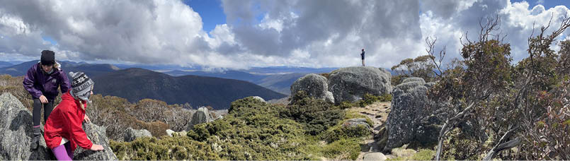
About a kilometre from the hut we reach the summit track, it’s a steep single track with water streaming down the track from the rain. The views are meant to be amazing but the air is misty and the mountain is obscured by cloud, so it feels like a real highland adventure. On the way up we see Flame Robins and White Winged Choughs flying among the wind-swept snow gums, but no views and no snow.
At the summit are a series of impressive granite boulders, with footpads leading in all directions. The kids immediately rush off to explore as Chris and I take in the atmosphere at a slower pace. From the other side of the summit we hear the excited cries of "Snow! Snow!" The kids have discovered deep snow drifts between the boulders on the southern face of the mountain and immediately start playing in it, throwing snow balls and trying to slide on their jackets. We remove the hard plastic frame from a daypack and punch a pair of holes at one end with my Swiss Army Knife. Then we thread a piece of cord through the holes to make a steering rope - in three minutes we have a little DIY toboggan. The kids spend the next hour sliding down a large snow drift, continually improving it until it resembles a section of luge track.
As we eat a picnic and share a flask of hot tea, the cloud over Mount Gingera lifts and an amazing view to the south appears. The kids are all soaked from their snow play and the sun helps to warm us up. We dismantle the "toboggan" and cross the summit where we take in the sweeping 360 degree views. It feels like we're on a different mountain to the one we climbed up in the morning. The kids rush off ahead in the direction of the hut and Chris and I take it slow, being careful not to fall on the slippery slope.
We return to camp, gather wood and light the fire for our second lunch. Chris asks for my knife to open a can and after checking my pockets I discover I've left it on the mountain. It's not quite three o'clock and it's less than five kilometres return so I decide to run back to Mount Gingera and climb up to look for it. None of the kids are keen for another climb so I pack a jacket, water and walking pole and
go solo. There's some heavy weather closing in from the west and the breeze is picking up, but I make good time and find the knife lying in the snow at the edge of our luge track. I'm the only person on the mountain and before I descend I take a moment to breathe in the air and bask in the view. I feel a sense of overwhelming gratitude to be immersed in the elements and the grandness of my surroundings.
Day 2 - Drying out

Gingera toboggan

31

Approaching camp I get a phone call - it's Andrew Pearce from Canberra who was thinking of joining us today with his two young kids but decided against it because of the weather forecast. Perplexed, I check the BOM app on my phone. There's a minimum temperature of one degree and 20 mm of rain expected overnight, with storms rolling in from the west - I rush back to the hut to share my screen shots of the forecast. We bolster our wood supplies, fortify ourselves with a hearty pasta dinner and watch the world premiere of the latest Brindabella Mountains horror movie (on the small screen). By the time we hit the tents, it’s cold outside and the sky is full of stars … Maybe the rain has passed us by?
Day 3: Pryors Hut To Corin Dam
It’s not yet midnight when the rain hits us. It’s heavy and constant and sounds like someone is blasting the tent with a fire hose. It’s also very cold. I always apply a “three bears” principal to our sleeping bag usage: Mary is the youngest, so she gets the warmest - an 18 °C snow camping bag. Daisy has the next
warmest goose down bag with a thermal liner. And I lie in the middle with our lightest bag, listening to the deluge waiting for the inevitable flood. But it doesn’t happen - the three of us are completely dry and once again I’m appreciating the qualities of our Mont Moondance tent, possibly the best investment I’ve ever made. The rain continues throughout the night and into the morning, but amazingly we have a good sleep and wake up around 6.30 am feeling fresh and ready for the new day. Chris, Ava and Rory also survived the night, thanks to their bombproof Vango Cairngorm tent. We all use the hut to dry off by the fire and pack everything ready for our departure. Today we will descend down Stockyard Spur to Corin Dam and emerge back into the world of cars and roads and noise.
We’re halfway through packing in the warmth of the hut when the rain changes. At first it becomes a kind of hail, then tiny beads of sago snow begin to fall among the raindrops. The little white beads become lighter and
Pryors Hut
32 | Bushwalk February 2023
fluffier and before long, big soft flakes of snow float down, covering everything in white. Ten-year-old Mary is beside herself with excitement. “I’ve never seen snow falling before!” By the time we are packed and ready to go the hut is blanketed by snow and looks just like the picture that excited Mary so much before the trip.
Descending the SpurWe take off at 10.45, following Mount Franklin Road to the turn off to Stockyard Spur and continue back the way we arrived. At the 1680 metre high point we look back towards Mount Gingera - the mountains are now covered in snow and the kids improvise “snow cones” by adding cordial onto snowballs.
Daisy’s hiking boots have a big hole in the sole after being cooked by the fire last night, so we put her foot in a plastic bag to help keep the slush out - but she barely notices. We pick up a good pace and are at the “helipad” by 12.45 pm. The climb down the spur is just as steep, but this time Chris and I are the slow ones with our middle-aged knee joints. The kids seem to have no problem and the section of walk that took us 2.5 hours to climb up ends up taking less than one hour to climb down. By 1.45 pm we are at the carpark, in dry clothes celebrating with cool cans of Guinness and soft drink for the kids.
The wrap upWe were looking for an authentic high country experience – complete with snow - a stone’s throw away from Canberra and we got more than we could have dreamed of. Despite the adverse weather we were comfortable by the fire inside the hut and the surrounding area was perfect for a couple of tents. The kids and adults all had a wonderful time and the trip has quickly become a highlight in our growing list of adventures. Stockyard Spur is not for the faint-hearted or for people who don’t like climbs. It is an unrelenting thigh-busting slog and if our kids were smaller or less experienced we probably wouldn’t have attempted it. If you want to access Pryors Hut and Mount Gingera but don’t want to smash yourself on the spur, you can reach another trackhead via Brindabella Road, Piccadilly Circus and Mount Franklin Road. This is a much longer drive and the steep unsealed mountain roads are sometimes closed to the public during high bushfire danger or in wet, snowy conditions. To access this route drive until the locked gate on Mount Franklin road and continue on foot for about 5 kilometres. The walk in is much easier and shorter than Stockyard Spur and a lot friendlier for
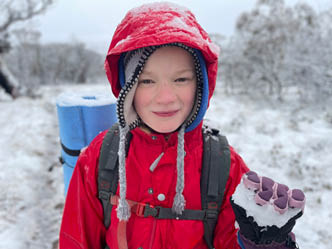
Mary enjoying the snow
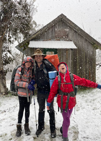
Daisy, Damian and Mary in front of Pryors Hut

33
Damian is a Canberra-born bushwalking and mountain sports enthusiast who lives in Sydney. Since 2017 he’s been taking his two young daughters out every season on a multi-day adventure and has (so far) managed to nurture their love of the outdoors without crushing their spirits. He writes about the adventures on his blog at randomfootprints.com with the hope of helping other parents find overnight adventures for kids.
The Author wishes to acknowledge the Ngunnawal people who are the traditional custodians of the land featured in this article.
"

kiddies. This route is also open to cycling and would make a great bike-packing trip. We considered taking the Mount Franklin approach but decided on Stockyard Spur for the challenge. It’s also a much easier drive, the entire road is sealed and is only 45 minutes away from my mum’s house in Kambah.
Useful info
There is a decent pit toilet near Pryors Hut, but no water tank. Fresh water is accessible about 100 metres from the hut, on the road to Mount Gingera where a stream runs from the mountain through a culvert towards the low swamps. There is another clean spring flowing from the mountain about half way to the Mount Gingera trackhead. The weather was very wet while we were there so water
was abundant, I’m not sure how reliable the water supply will be in summer or during drought periods. The alpine environment can be unpredictable with extreme weather, high winds and snow possible any time of year, so make sure you are always prepared with adequate warm weather gear including sleeping bags rated to zero degrees or below. There is mobile reception on Mount Gingera but don’t rely on it. Always let someone know your trip intentions and carry a PLB if possible. It’s also a good idea to contact the Namadgi Visitors Centre while you’re planning your trip.
Mountain huts are maintained by volunteers and parks staff, so be sure you keep them clean, take all rubbish away with you and replace any firewood you use. The huts are only meant for sleeping in an emergency so always bring a shelter and set up your tent a good distance away from the hut to allow other hut users access.
For more info about Pryors Hut check out the KHA Website.
Find out more about Ngunnawal culture and heritage on the Tidbinbilla Website.
For info on the shorter route to Pryors Hut check out Australian Hiker.
Day 3 - Finish
34 | Bushwalk February 2023