

Designated as a wilderness area, Morton National Park is one of those places where you can get lost in time and is more commonly referred too as The Budawangs. It is located approximately 2-3 hours from Sydney as there are numerous ways to gain access to the park. The most popular access seems to be via The Castle at Yarboro just inland from Milton. But you can also gain access from Wog Wog, Neriga and Sassafras. The latter being closer to our objective, was our chosen entry point. You can access all of the locations with a 2WD but most of the roads can get rather rough and it’s much more pleasant in a 4WD.
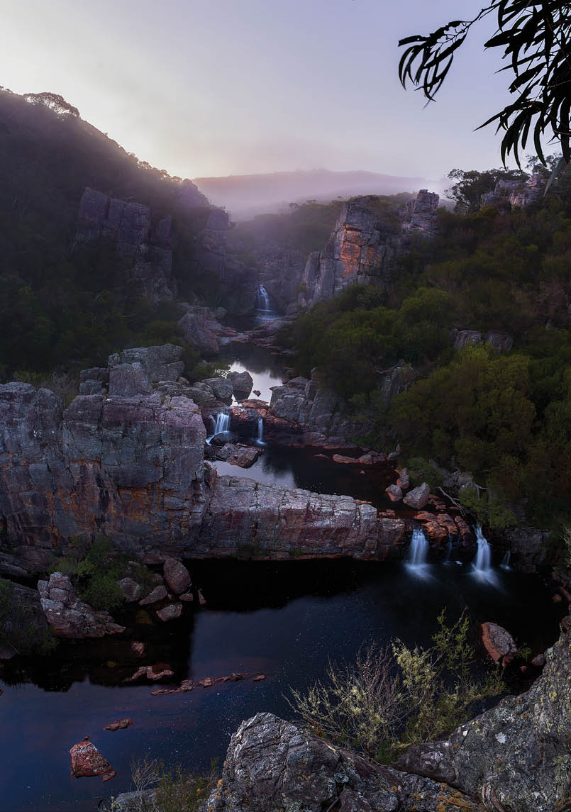
A misty morning looking out to the rock ribs and listening to the soundtrack of cascades and birds.All pictures by Daniel Toplicescu

Sassafras to Wog Wog
Daniel Toplicescu

18 | BWA December 2019

In the first week of May 2019 I led two people from Sassafras to Wog Wog going through Hollands Gorge. I’ve always been curious about it and it surpassed expectations.
I decided to splurge on luxuries this trip. Despite my base weight being in at around 10 kilograms, my pack was around 24 kilograms once camera gear, luxury food and gear was included. It's been a while since I've had that much weight but it was worth it - or so I kept telling myself as I sat on my chair every night and enjoyed some good red.
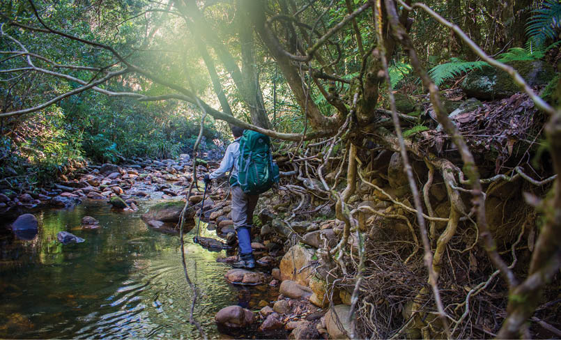
Day 1 – Sassafras to Watson Pass camping cave We started walking in from the Sassafras entrance at 6.30 am. About 8.30 am we turned off the fire trail and headed down the foot pad towards Folly Point. Bits of pink ribbon, not tape were cut at lengths of about 15 cm stuck only on obvious parts of the trail at every turn. After the first couple, I decided to carry them out. The foot pad is well defined and easy to follow for the most part, but a lot of trees are fallen making walking with a pack a bit more awkward. Where the grass was longer I managed to step on the head of a large snake (tiger? maybe). It was barely moving after that ... Poor thing. Glad I decided to stick the gaiters on early.
We arrived at Folly Point at lunchtime where we planned to set up camp on top. But after consulting the forecast while we had the reception at the lookout, we learnt that we'd get rain later that afternoon till the next day. So we opted to go find the camping cave south-east of Watson Pass.
So after an extended lunch, we left to go look for the camping cave. After Watson Pass, there is a cairned route to the camping cave after following the cliff line east a little but not completely to the end of the trail. It's easy to miss as the well-defined track continues. We missed it the first day and ended up bashing a good part of the way down and having to navigate some small cliffs to the creek at Endrick 490960. We dropped into the creek a bit too upstream and had an interesting time getting past the slippery drops and waterfalls in the creek. It was starting to get rather dark when I noticed a faint track heading back up out of the creek which funnily enough led to the camping cave. This was a bit after 5 pm, so it was a long day. Glad we didn't have to settle for whatever spot we could find because the forecast was right and we were able to stay dry. There is a small creek next to the cave that had about 20 semi-continuous drips going for it. We filled up our bottles with ease using an emergency blanket as a funnel.
The Castle and Darri Head from Munnuldi Falls
BWA December 2019 | 19

Day 2 – Watson Pass camping cave day tripWe planned to do a day trip and go see sluice box falls but when the weather is really rubbish and you’re in a dry cave by a nice fire, the idea of bush bashing all day through steep terrain is not overly appealing ... So we opted to eat food and relax. By lunchtime, the weather cleared up and I'd had enough relaxing so we decided to go part way and at least see Munnuldi Falls. This trip took us about 3.5 hours. We headed up towards Watson Pass again following the cairns this time (way easier). From Watson Pass you head straight down where if you have a keen eye you can find a bit of a route but that’s on and off. Just before Munnuldi Falls, there is a lovely camping cave very close to Camping Rock Creek which I believe is also the access into the creek if you want to cross it. But that's as far as we decided to explore, settling for a swim in an awesomely large and deep pothole in the creek. How it feels to be clean!
Then we headed back to our camping cave and got ready for an early start. The scrub can get really thick between the falls and Watson but if you stay on the spur the vegetation is pretty open by Budawang standards.
Day 3 Watson Pass camping cave to Angels CreekWe followed a track on the southern side of the creek next to the camping cave keeping elevation till it disappeared. After five minutes of searching, I opted to just find our own way instead of fluffing around to find where this track goes. Funnily enough, this was the last bit of pink tape we saw too for at least a day. I'd accumulated half an A4 ziplock bag full of pink ribbons and tape by this stage! We started to head down toward Camping Rock Creek and eventually followed the second tributary down to it. From here on it was surprisingly easy going by Budawang standards again. Just follow the creeks and at times walk alongside it needed switching sides as needed. Absolutely stunning gorge scenery at this point. I will definitely be back. There were a few campsites before the junction of Camping Rock Creek and Hollands Creek. Otherwise, the only flat spot is at the junction of Angels Creek and Hollands Creek. This campsite is absolutely superb but it was only after lunch. At this stage one member of the group was struggling and was rather tired. But we needed to make our pick up so we pushed on. From that campsite, we followed the ridge straight up which saved us dealing with scrub. This took as a while.
Doing our best to keep our boots dry. The full force of the water can be seen along the banks of Hollands Gorge.
20 | BWA December 2019

Hollands Creek
A lot of time was spent waiting for our tired party member. I was particularly not looking forward to this bit due to the rapid climb in elevation but even though steep, if you’re reasonably fit it isn’t really that bad. The lack of scrub bashing made it relatively easy for a steep climb. Even with my pack – now 20 kilograms - I never felt like I needed to stop going up the ridge.
At the cliff just north-west of Crooked Falls we found a track that follows the bottom towards Angel Creek and an abandoned pack which turns out was left there a few weeks prior when a guy got airlifted out with an ankle injury.
The track hugs the cliffs turning west where we left our tired party member to take a look at the Crooked Falls lookout. What a steep decent to the lookout - 100+ metres loss in about 50 metres. It's well worth it though! Not the place to have a tumble.
Once we got back to our friend and packs we continued to follow the track. But it was getting rather dark at this stage. The track seemed to disappear we made our own way again but it was pretty open rainforest so not too bad. We came across a lovely flat bit near Angels Creek which was as far as we
got. Although we had planned to get to Mt Cole, by the time we took our packs off it was dark and we needed headlights. It was only about 4.30 pm but the canopy and the steepness of the gorge made it dark a whole hour and a half earlier.
Somehow the red tasted so much better after the steep climb.
Day 4 – Angels Creek to Corang RibsThe next day we went and checked out the top of Crooked Falls before pushing on. I'd planned a shorter day as I was unsure of the terrain in Hollands Gorge and the fitness of the party. You would do well to have good navigational skills before going off track in these parts. We continued through Angels Creek until the cairns stacked in the middle of the creek indicated our ascent. These days there is a reasonable track from Angels Creek up to the track going to Donjon’s base. The pink tape began again but you'll be glad to note that the area is free of it once more. Water from the camping cave at Watson Pass up to the ascent at Angels is pretty solid. Next time I think I'd bring a little carabiner and leave the water bottles empty for that stretch and just use my cup; attaching it to my pack.
BWA December 2019 | 21
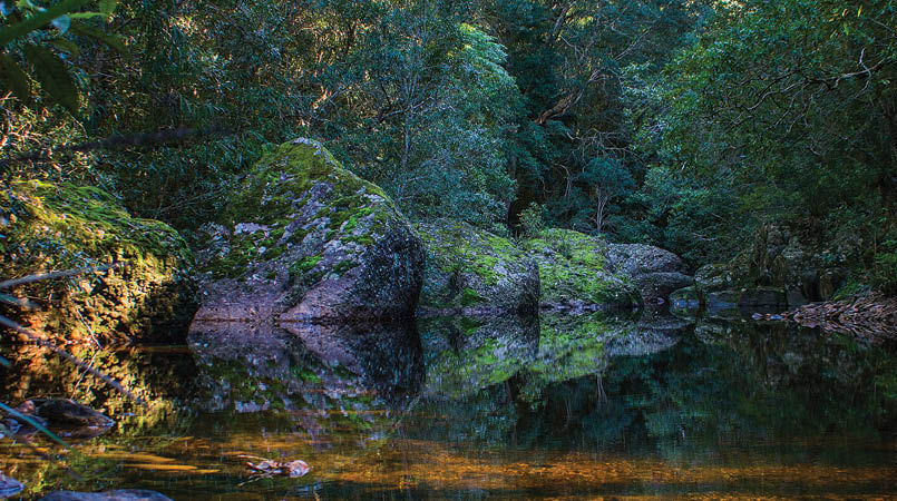

Quiet reflections along Hollands Creek
Daniel is a graphic designer and budding landscape photographer who likes to go bushwalking instead of just talking about it. Popular places do not appeal to him and is always looking for remote places to explore. Although living on the coast he prefers the mountains and is always looking for a walking buddy that isn’t turned off by scratchy leaves.
He is always looking for an opportunity to wear a down jacket and find an icy swimming hole. He knows that a mountain can take your breath away twice.

There was a bit of water to be heard between the "splendid" camp cave described in the Rod Doughton book and the small sandy overhang further up toward Donjon's base. The next water we came across was on the outskirts of Mount Bibbenluke in the rainforest area between its two spurs. From the intersection of the Mount Cole-Monolith-Donjon tracks its pretty well defined footpad as most probably know already, all the way out to the Wog Wog car park. We headed west past Cole and Bibbenluke. I wanted to go check out Murrumbooie Falls but no one else in the party was up for it so we kept on going.
Just before the intersection arriving at the intersection to Yurnga Lookout at about Corong 396927 there is a very well maintained track heading south-west. Very interested as to where it goes. The first 20 metres seems scrubby but the more you follow it the better it gets. We didn't have time to explore it further.
We decided to push on to camp near the Corang ribs after taking a look at Yurnga Lookout and skipping the Corang Arch as those in my group were pretty wiped. Has anyone used the pass just below the lookout? Looks like you could use the ridge below it to make your way to the Yarboro River.
We got to our camp just before dark and had a fantastic view of the night’s sky. We saw lots of meteors from the meteor shower we just had and not a single cloud to contend with.
Day 5 - Corang Ribs to SassafrasWe had a lazy morning and was planning to go for a swim in the morning but it was a bit fresh so we decided to walk to the Corang Lagoon for a swim after warming up first. Glad we went for a warm up as the water was an invigorating 7.1 degrees according to my watch. We had lunch and dried off in the sun before heading off and getting to the Wog Wog car park by 2.50 pm. No signs of signs or anything from the property owner at the lagoon. Day 5 was the easiest day by far.


22 | BWA December 2019