Scenic World down Furber Steps to Narrow Neck Loop
Dharug & Gundungurra Country

3 h 45 min to 5 h

7.2 km
circuit

↑ 844 m
↓ -844 m

Hard track
This walk starts from the popular Scenic World tourist spot. The walk winds down into the Jamison Valley via the Furber steps, heads west around the edge of the valley, past the landslide, and climbs the Golden Stairs, before returning to Scenic World along the roads. This is a great day walk, providing access to some nice, optional side trips. As an alternative to the walk down, you can take the popular Scenic Railway down into the Jamison Valley. Let us begin by acknowledging the Dharug & Gundungurra people, Traditional Custodians of the land on which we travel today, and pay our respects to their Elders past and present. 
Show all
Entrance to Scenic World. | Photo by admin, 2008.
following the wooden footbridge. | Photo by admin, 2008.
following the hardened dirt path. | Photo by admin, 2008.
Mist from Vaniman's Lookout 1940 Wallace Green. | Photo by admin, 2008.
Vanimans Lookout. | Photo by admin, 2008.
Looking through the trees to the Katoomba Falls. | Photo by admin, 2008.
Juliets Balcony view. | Photo by admin, 2008.
winding down into the Jamison Valley. | Photo by admin, 2008.
Katoomba Falls. | Photo by admin, 2008.
Small sheltered rest area. | Photo by admin, 2008.
Top of Furber Steps. | Photo by admin, 2008.
Furber Lookout. | Photo by admin, 2008.
Going under the cliffs to Vera's Grotto. | Photo by admin, 2008.
Vera's Grotto. | Photo by admin, 2008.
The occassional set of steep stairs. | Photo by admin, 2008.
Turpentine Tree. | Photo by admin, 2007.
Following the track along the valley floor. | Photo by admin, 2007.
Bottom Platform of the Scenic Railway. | Photo by admin, 2007.
Looking up at Malaita Point. | Photo by admin, 2007.
bottom of the Golden Stairs. | Photo by admin, 2008.
winding up and along the cliffs. | Photo by admin, 2008.
The view from Botting's Lookout. | Photo by admin, 2008.
The Golden Staircase Carpark. | Photo by admin, 2008.
Start of Glenraphael Drive. | Photo by admin, 2008.
Downloads GPX PDF

+
-
Safer Bushwalks
Tips on staying safe on track
Before you start any bushwalk ensure you;
• Tell someone you trust where you are going and what to do if you are overdue
• Have adequate equipment, supplies, skills & knowledge for the whole journey
• Consider the impact of weather forecasts, park/track closures & fire dangers
• Can respond to emergencies & call for help at any point
• Are healthy and fit enough for this journey
If not, change plans and stay safe. It is okay to delay and ask people for help.
+
-
Getting There
Transport options and directions
Start (-33.7285118,150.3007652)
Mode Bus Car (There is free parking available.)
DirectionsFrom Great Western Highway, A32
  • Turn on to then drive for 85 m
  • Turn slight left onto Parke Street, BMD and drive for another 75 m
  • At roundabout, take exit 1 onto Bathurst Road, BMD and drive for another 155 m
  • At roundabout, take exit 2 onto Katoomba Street and drive for another 570 m
  • At roundabout, take exit 2 onto Katoomba Street and drive for another 850 m
  • Keep right onto Katoomba Falls Road and drive for another 325 m
  • Continue onto Katoomba Falls Road, BMD and drive for another 390 m
  • Turn left onto Cliff Drive, BMD and drive for another 360 m
  • Turn left and drive for another 105 m
+
-
Track Notes
Turn by turn instructions & maps
Getting started
From the Scenic World main entrance, this walk follows the 'Prince Henry Cliff Walk' signs down the concrete steps and around to the back of the building, where it comes to a wooden footbridge that curves around behind the main car park. At the end of the footbridge, this walk comes to an intersection with the Prince Henry Cliff Walk.....
Turn map Directions & comments
Start heading along Prince Henry Cliff Walk.
After another 3 m veer right.
Find the Scenic World at the start.
Scenic World
Scenic World

Scenic World is one of the most renowned tourist attractions of Katoomba and the Blue Mountains. Located on the cliffs of the Jamison Valley , visitors can enjoy a ride on the Scenic Railway (the world's steepest incline railway) or the Scenic Cableway, into the Jamison Valley, and explore the Scenic Walkway from the base. Alternatively, the Scenic Skyway offers a bird's eye view over the valley, with a glass floor to enhance the experience. Scenic World also features a revolving restaurant, a cafe and a kiosk, in addition to the documentary theatre and souvenir shop. Rides can be purchased, starting from $16 for adults and $10 for children, and combination or family passes are available.
+
-
Scenic World is one of the most renowned tourist attractions of Katoomba and the Blue Mountains. Located on the cliffs of the Jamison Valley , visitors can enjoy a ride on the Scenic Railway (the world's steepest incline railway) or the Scenic Cableway, into the Jamison Valley, and explore the Scenic Walkway from the base. Alternatively, the Scenic Skyway offers a bird's eye view over the valley, with a glass floor to enhance the experience. Scenic World also features a revolving restaurant, a cafe and a kiosk, in addition to the documentary theatre and souvenir shop. Rides can be purchased, starting from $16 for adults and $10 for children, and combination or family passes are available.

Find the car park at the start.
Continue straight.
After another 10 m pass the toilet (20 m on your right).
After another 10 m cross the bridge (about 70 m long)
After another 50 m (at the intersection of Katoomba Falls Round Walk & Prince Henry Cliff Walk) turn right, to head along Katoomba Falls Round Walk.
After another 45 m turn right, to head along Katoomba Falls Round Walk.
After another 25 m find the "Vaniman's Lookout" (on your left).
Vaniman's Lookout
Vaniman's Lookout

Vaniman's Lookout is a fenced, long and narrow lookout on the cliff edge, opposite Reids Plateau. The view looks directly over the Three Sisters across the Kedumba Valley, under the Scenic Skyway. The lookout was considered one of the finest views on the Three Sisters in the 1900's. The lookout was named after Chester Melvin Vaniman in 1905, a well-know adventurer and artist from the USA, who visited the Blue Mountains in 1903.
+
-
Vaniman's Lookout is a fenced, long and narrow lookout on the cliff edge, opposite Reids Plateau. The view looks directly over the Three Sisters across the Kedumba Valley, under the Scenic Skyway. The lookout was considered one of the finest views on the Three Sisters in the 1900's. The lookout was named after Chester Melvin Vaniman in 1905, a well-know adventurer and artist from the USA, who visited the Blue Mountains in 1903.

After another 115 m pass a seat (on your right).
After another 15 m continue straight, to head along Katoomba Falls Round Walk.
After another 30 m find the "Juilets Balcony" (5 m on your right).
Juilets Balcony
Juilets Balcony

Juliets Balcony is a spectacular lookout, perched on top of a rock buttress near Orphan Rock, under the Scenic Skyway. The lookout provides sweeping views of the start of the Kedumba Valley, from Katoomba Falls to the Three Sisters. The lookout is accessed by a staircase, off the Furber Steps track. The fenceline continues along the lookout, forming a long, fenced balcony.
+
-
Juliets Balcony is a spectacular lookout, perched on top of a rock buttress near Orphan Rock, under the Scenic Skyway. The lookout provides sweeping views of the start of the Kedumba Valley, from Katoomba Falls to the Three Sisters. The lookout is accessed by a staircase, off the Furber Steps track. The fenceline continues along the lookout, forming a long, fenced balcony.

After another 35 m (at the intersection of Furber Steps & Katoomba Falls Round Walk) turn right, to head along Furber Steps (a steps).
Then head down the steps (about 490 m long)
Turn right, to head along Furber Steps.
After another 8 m pass the "Rainforest Lookout" (6 m on your left).
After another 6 m find the "Rainforest Lookout" (15 m on your left).
Rainforest Lookout
Rainforest Lookout

Unlike many lookouts in the area, Rainforest Lookout does not offer sweeping valley views. Instead, this lookout offers an opportunity to get up close and personal with the canopy of the rainforest. Spend some time in the cool shade listening to the birds and Witches Leap creek passing by. A sign at the lookout explains that there once were wood-fired barbeques here for picnics, but removed due to the toll on the local environment.
+
-
Unlike many lookouts in the area, Rainforest Lookout does not offer sweeping valley views. Instead, this lookout offers an opportunity to get up close and personal with the canopy of the rainforest. Spend some time in the cool shade listening to the birds and Witches Leap creek passing by. A sign at the lookout explains that there once were wood-fired barbeques here for picnics, but removed due to the toll on the local environment.

Then pass the "Plant Life on the Edge" (6 m on your left).
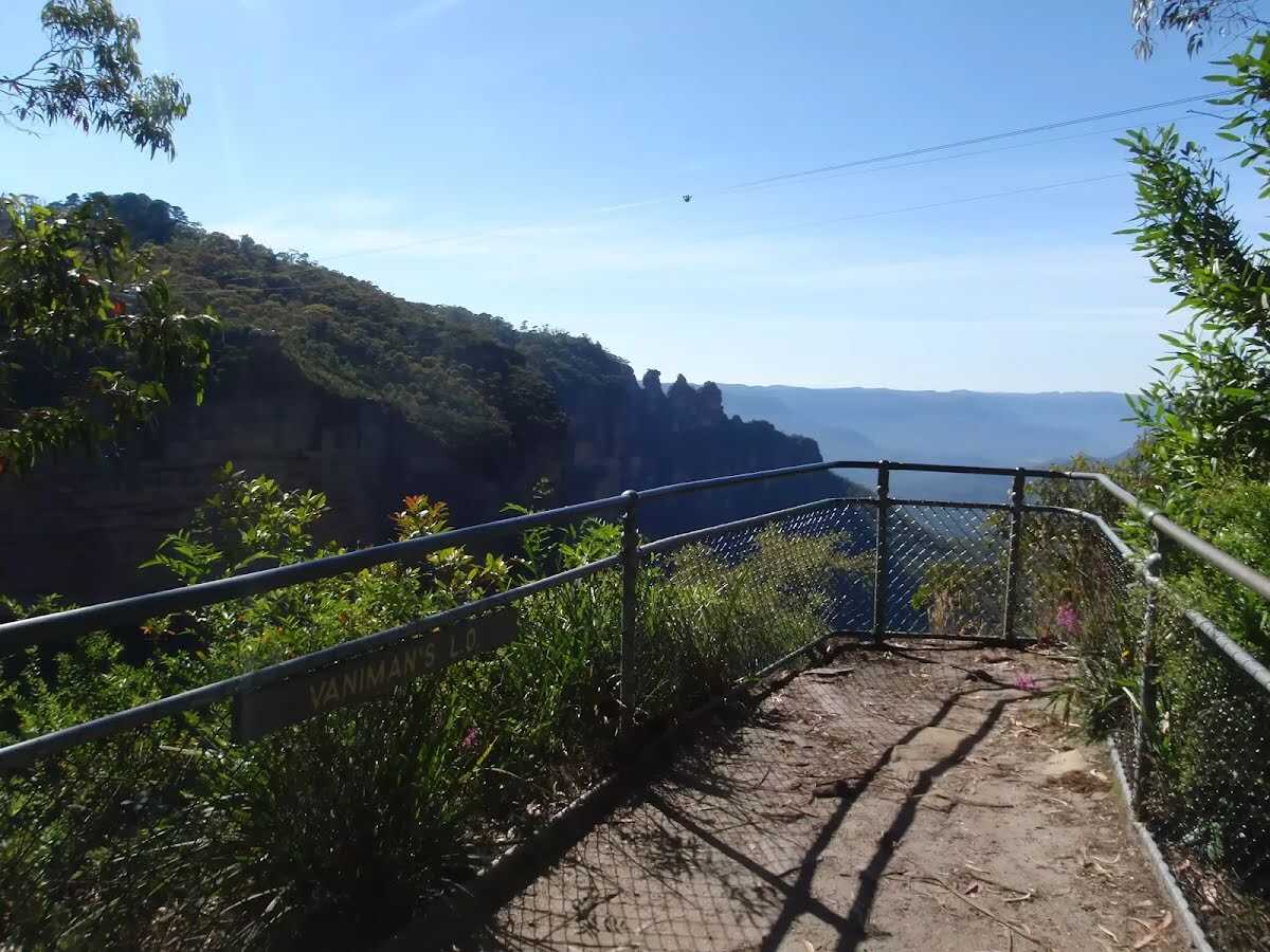
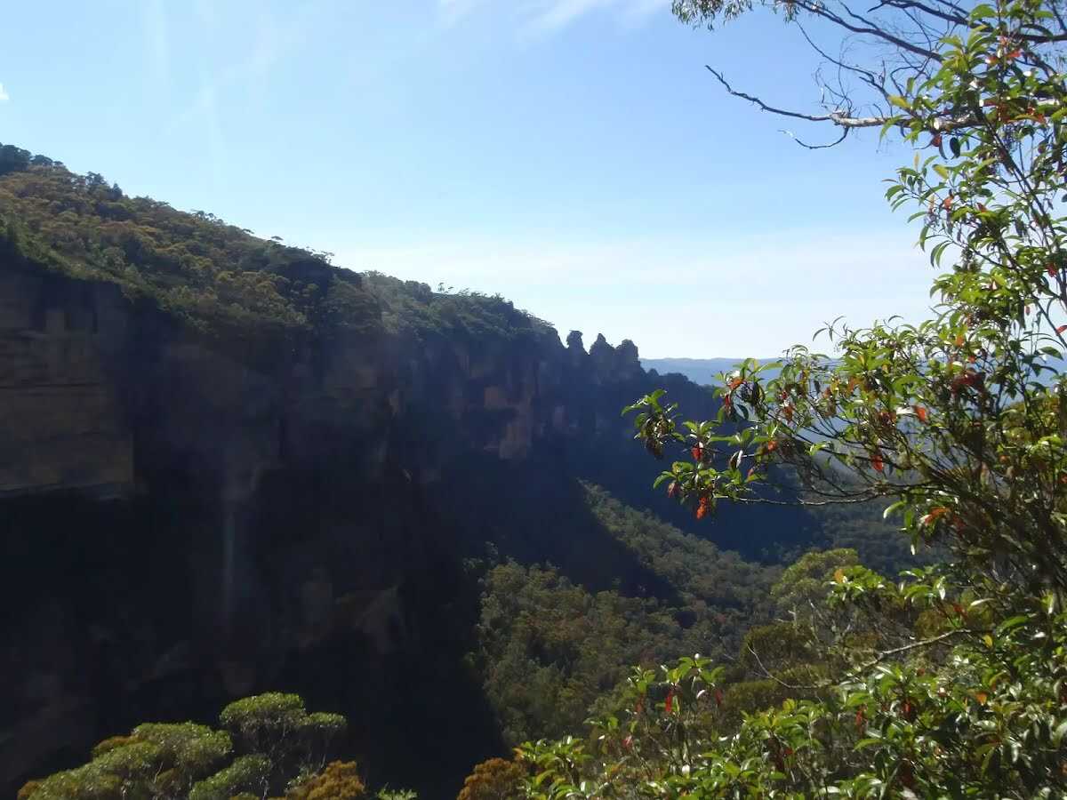
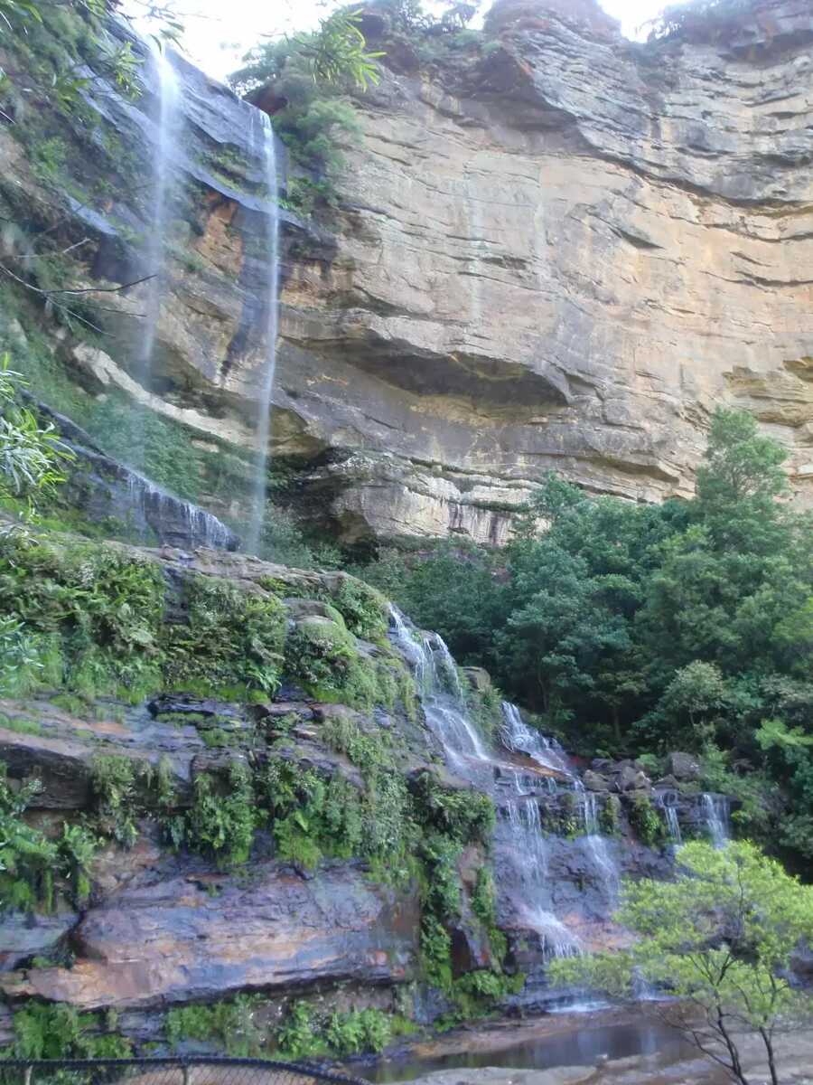
The starting point of an optional sidetrip. An optional side trip to Katoomba Falls. To start this optional side trip turn left here. On returning from this side trip turn left when you get back to this intersection. Details below.
After another 20 m (at the intersection of Furber Steps & Underfalls Walk) continue straight, to head along Furber Steps.
After another 80 m pass a seat (on your left).
After another 20 m turn right, to head along Furber Steps.
After another 55 m come to the "Queen Victoria Lookout" (6 m on your left).
Turn right, to head along Furber Steps.
After another 55 m find a seat.
Then come to the "Furber Lookout" (on your right).
After another 55 m come to the "Lynes Point" (8 m on your left).
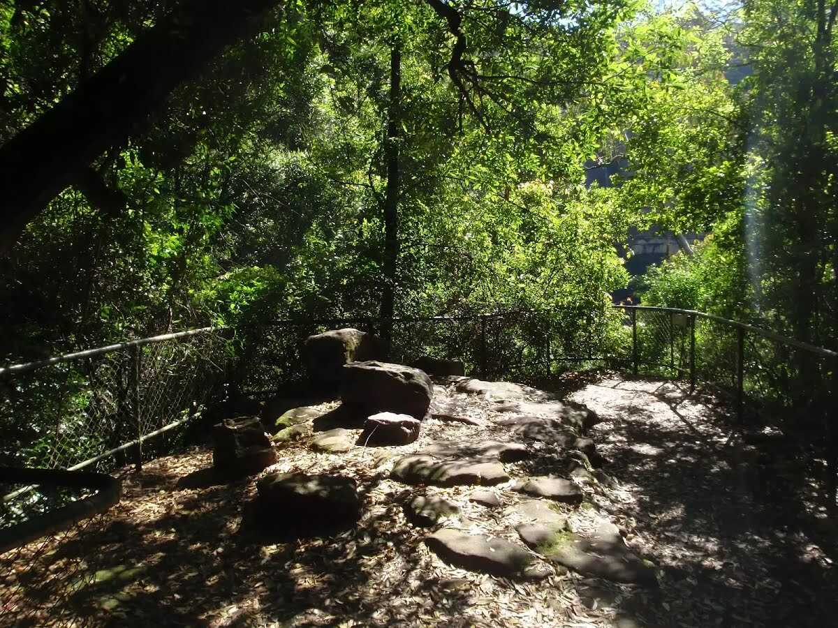
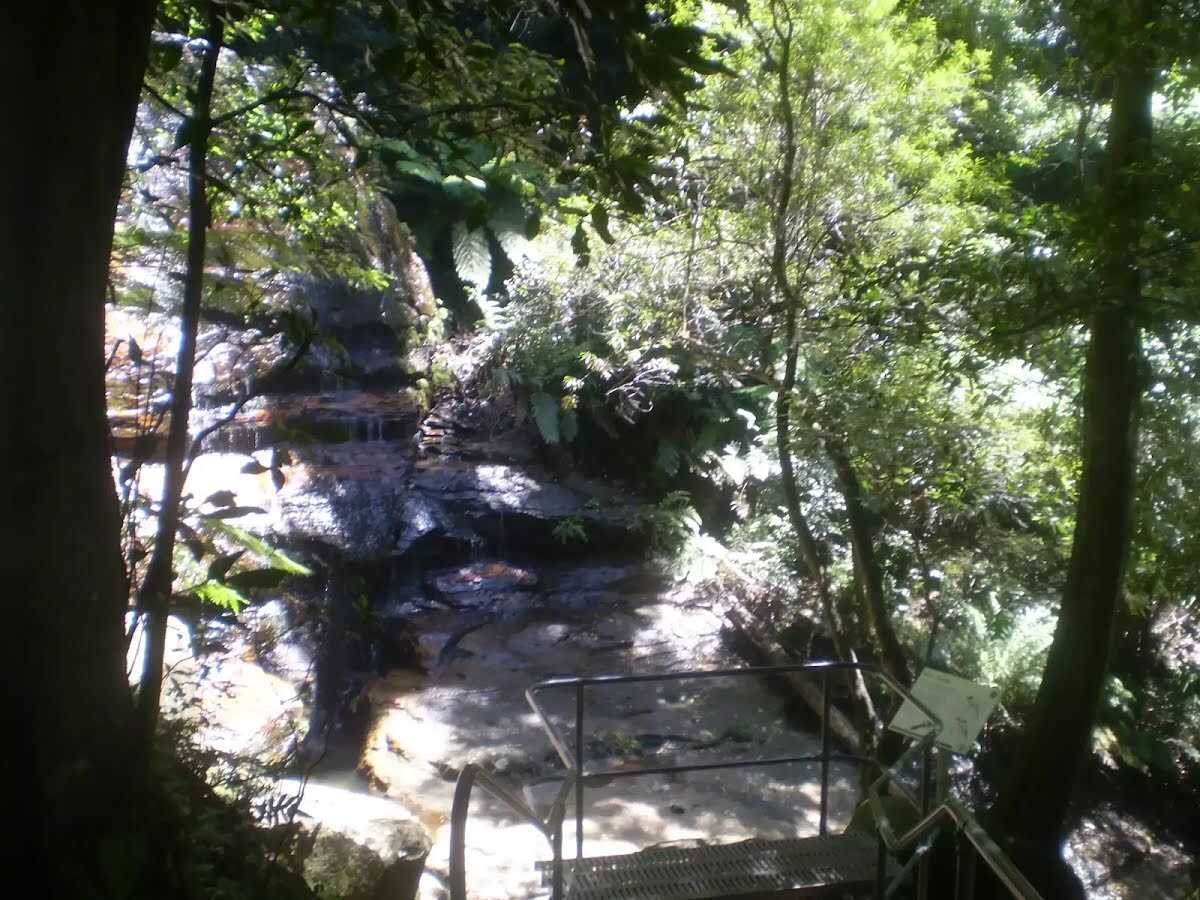
The starting point of an optional sidetrip. An optional side trip to Vera's Grotto. To start this optional side trip turn left here. On returning from this side trip continue straight when you get back to this intersection. Details below.
After another 60 m veer right, to head along Furber Steps.
After another 165 m (at the intersection of Furber Steps & Federal Pass) continue straight, to head along Federal Pass (a walking track).
After another 30 m pass a seat (on your left).
After another 140 m head through/around the gate.
Then cross the bridge (about 4 m long)
After another 6 m come to the "Scenic Railway" (10 m on your left).
After another 70 m (at the intersection of Federal Pass Walking Track & Scenic Walkway) continue straight, to head along Federal Pass Walking Track.
After another 10 m pass the artwork (on your right).
After another 160 m pass a seat (8 m on your left)., has no backrest.
After another 1.2 km find the "The Landslide" (35 m on your left).
The Landslide
The Landslide

'The Landslide' is a large rockfall going into the valley approximately 100m. There is a good vantage point for the landslide from under the cliffs to the east, and a great but more distant view from Narrow Neck lookout. The landslide occurred in 1931 after a few days of rumbling. There has been much debate as to whether this event was helped along by erosion and coal mining in the area at the time.
+
-
'The Landslide' is a large rockfall going into the valley approximately 100m. There is a good vantage point for the landslide from under the cliffs to the east, and a great but more distant view from Narrow Neck lookout. The landslide occurred in 1931 after a few days of rumbling. There has been much debate as to whether this event was helped along by erosion and coal mining in the area at the time.

After another 1.5 km (at the intersection of Federal Pass & Golden Stairs) turn right, to head along Golden Stairs.
After another 70 m pass the sign (on your left).
After another 460 m find the "Botting's Lookout" (5 m on your right).
Botting's Lookout
Botting's Lookout

Botting's Lookout offers great views over the Jamison Valley and the cliff line, including the Landslide, Malaita Point and the Golden Stairs. A plaque at the lookout states that the lookout was named after Walter Botting (1887-1985), a pioneer trail-maker of the Katoomba District.
+
-
Botting's Lookout offers great views over the Jamison Valley and the cliff line, including the Landslide, Malaita Point and the Golden Stairs. A plaque at the lookout states that the lookout was named after Walter Botting (1887-1985), a pioneer trail-maker of the Katoomba District.

After another 160 m to find the "Golden Stairs Car Park".
After another 2 m (at the intersection of Glenraphael Drive & Golden Stairs) turn right, to head along Glenraphael Drive (a vehicle track).
After another 25 m pass the sign (5 m on your right).
After another 310 m continue straight.
After another 45 m turn left, to head along Glenraphael Drive.
After another 195 m continue straight, to head along Glenraphael Drive.
After another 115 m come to the viewpoint (45 m on your right).
Then pass the car park (10 m on your right).
After another 240 m (at the intersection of Glenraphael Drive & O'Sullivans Folly) turn left, to head along O'Sullivans Folly.
After another 10 m turn right.
After another 360 m continue straight, to head along Glenraphael Drive.
After another 250 m continue straight, to head along Glenraphael Drive.
After another 360 m (at the intersection of Cliff Drive & Glenraphael Drive) turn sharp left, to head along Cliff Drive (a road).
After another 25 m turn right.
After another 75 m turn right, to head along Violet Street.
After another 60 m continue straight, to head along Violet Street.
After another 10 m continue straight, to head along Violet Street.
After another 205 m continue straight, to head along Violet Street.
After another 55 m come to the "KCC Camp Site" (135 m on your right).
About 15 m past the end is a toilet.
At the intersection of Violet Street & Cliff Drive continue straight, to head along Violet Street (a service road).
After another 180 m come to a car park.
Then pass the "Scenic World" (20 m on your right).
After another 50 m come to the end.
About 15 m past the end is a toilet.

An optional side trip to Katoomba Falls.
Turn map Directions & comments
At the intersection of Underfalls Walk & Furber Steps Start heading along Underfalls Walk (a walking track).
After another 45 m cross the bridge (about 5 m long)
After another 110 m find the "Vera's Grotto" (30 m on your right).
Vera's Grotto
Vera's Grotto

Vera's Grotto is a pleasant little spot located amongst the cascades on Witches Leap creek. This is a great area for lunch on a hot day, as it is always kept cool by the falls and the shade from the surrounding trees. When venturing to the grotto, you may be lucky enough to spot the Whistler and Yellow Robins. Superb Lyrebirds are also heard and even seen frequently in the surrounding area.
+
-
Vera's Grotto is a pleasant little spot located amongst the cascades on Witches Leap creek. This is a great area for lunch on a hot day, as it is always kept cool by the falls and the shade from the surrounding trees. When venturing to the grotto, you may be lucky enough to spot the Whistler and Yellow Robins. Superb Lyrebirds are also heard and even seen frequently in the surrounding area.

After another 55 m come to the end.
A viewpoint.
About 10 m past the end is "Katoomba Falls".
Katoomba Falls
Katoomba Falls

The Katoomba Falls are among the most famous waterfalls in the the Blue Mountains region. The Kedumba River falls about 150 meters in 2 main stages. The Undercliff Track, from the Furber Steps, can be used to access the first landing of the waterfall. The Katoomba Falls can be viewed from most lookouts in the the area, including from the bottom of the falls at Cooks Landing on Federal Pass, or from the track running next to the Kedumba River at the top of the falls. These falls are also a highlight for the trip across the Scenic Skyway.
+
-
The Katoomba Falls are among the most famous waterfalls in the the Blue Mountains region. The Kedumba River falls about 150 meters in 2 main stages. The Undercliff Track, from the Furber Steps, can be used to access the first landing of the waterfall. The Katoomba Falls can be viewed from most lookouts in the the area, including from the bottom of the falls at Cooks Landing on Federal Pass, or from the track running next to the Kedumba River at the top of the falls. These falls are also a highlight for the trip across the Scenic Skyway.

Turn around and retrace your steps back the 215 m to the main route.

An optional side trip to Vera's Grotto.
Turn map Directions & comments
Start.
Continue another 25 m to find Vera's Grotto at the end.
"Vera's Grotto".
About 30 m past the end is "Vera's Grotto".
Vera's Grotto
Vera's Grotto

Vera's Grotto is a pleasant little spot located amongst the cascades on Witches Leap creek. This is a great area for lunch on a hot day, as it is always kept cool by the falls and the shade from the surrounding trees. When venturing to the grotto, you may be lucky enough to spot the Whistler and Yellow Robins. Superb Lyrebirds are also heard and even seen frequently in the surrounding area.
+
-
Vera's Grotto is a pleasant little spot located amongst the cascades on Witches Leap creek. This is a great area for lunch on a hot day, as it is always kept cool by the falls and the shade from the surrounding trees. When venturing to the grotto, you may be lucky enough to spot the Whistler and Yellow Robins. Superb Lyrebirds are also heard and even seen frequently in the surrounding area.

Turn around and retrace your steps back the 25 m to the main route.
+
-
Terrain
Know the Hills, grading & facilities

Scenic World down Furber Steps to Narrow Neck Loop


Grading
Class 4/6
Hard track
Length 7.2 km
Time 3 h 45 min to 5 h
Quality of track Rough track, where fallen trees and other obstacles are likely (4/6)
Gradient Very steep (4/6)
Signage Directional signs along the way (3/6)
Infrastructure Limited facilities, not all cliffs are fenced (3/6)
Experience Required Some bushwalking experience recommended (3/6)
Weather Weather generally has little impact on safety (1/6)

Some facilities on route
Camp site: There is one 7.1 km from the start.

Toilet: There are 3 on route, on average they are 1.9 km apart with the largest gap of 7.2 km.

Seat: There are 5 on route, on average they are 1.2 km apart with the largest gap of 5.9 km.


Order of key facilities on route
ItemFrom StartName & link to notes
Toilet
50 m[toilet]
Seat
370 m[seat]
Seat
570 m[seat]
Seat
650 m[seat]
Seat
960 m[seat]
Seat
1.3 km[seat]
Camp site
7.1 kmKCC Camp Site
Toilet
7.3 km[toilet]
Toilet
7.4 km[toilet]
+
-
Articles
Discover more details to thrive on track
Get more information
Wildwalks
+
-
Reviews & Feedback
Share your experience
+
-
Weather & Alerts
Check forecasts & closures
Show Full Weather
Alerts and Closures
Show all alerts
Show all alerts
Show all alerts
+
-
Other Journeys
Discover nearby and similar journeys
Some of the information and maps on this page was generated using data from the awesome © OpenStreetMap contributors.
Please see how you can embed some widgets, access data and other stuff to that might be helpful.