My wife was very disappointed that we only zipped through Taupo on the way from Rotorua to National Park.
She thought it loooked like a nice place to kick back and relax for a few days.
It is central to both Tongariro and the Rotorua areas - so you could visit a few thermal areas as well as the volcanoes to the south.
Towards Rotorua, I would recommend a short walk at Rainbow Mountain - which can be worked into wandering around the nearby Wai-o-topu thermal area.
There is also a short dirt road in that area to Kerosene Creek if you want to soak in a hot river for 10 mins - the road starts at Green Lake.
 Viewed 12614 times")
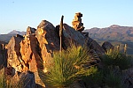
- Steam rising from far edge of Green Lake below Rainbow Mountain
There is a pamphlet on walks around Taupo - which would include various length walks to/from Huka Falls and various cliffs/ranges around Lake Taupo itself.
Brochure can be downloaded from :
http://www.greatlaketaupo.com/new-zealand/walks/Tongariro is not a long way away - but travel time from Taupo could go from 1 to 2 hrs depending on your destination.
A long drive would be a drive right around the park covering the Desert Road side as well as the Whakapapa side - with some short walks along the way.
Being April, it may have a lot more snow around than we had in Jan - and that may affect what you plan to do.
The park HQ is at Whakapapa and the walk to Taranaki Falls was from there [about 2 hours - but it is part of a complex of tracks with other options].
The Tongariro Alpine Crossing is rated as the best one day walk in NZ - but really does take a full day [7-8 hours] and you need to arrange transport to both ends. A lot of companies can provide this.
For some detail see
http://www.doc.govt.nz/parks-and-recreation/tracks-and-walks/central-north-island/ruapehu/tongariro-alpine-crossing/And more general:
http://www.doc.govt.nz/parks-and-recreation/national-parks/tongariro/activities/If the snow cover allows - Mt Ruapehu would be really worth doing - though there is a shorter option called the "Skyline walk".
[Some businesses will guide you up providing gear for snow walking if it is required.]
In both cases you would be advised to use the chairlifts and arange your times to back by 4pm to get the last trip down for the day.
[We took the first lift at 9 am and came back on the last at 4 pm - making it a 7 hour walk - but we did take a difficult and longer route and were quite relaxed throughout the walk]
The cafe at the base of the chairlifts can give you details about weather and walk conditions as well as the Skyline option.
All of NZ topographic maps can be downloaded from
http://www.linz.govt.nz/topography/topo-maps/map-chooser/index.aspx, but you can purchase the park map at Whakapapa visitor centre as well.
I am sure there are more options than this - but it is a start.