Mt HOWITT
Victoria specific bushwalking discussion. Please avoid publishing details of access to sensitive areas with no tracks.
Mt HOWITT
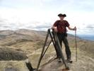
![]() by gisborne612 » Thu 03 Jun, 2010 2:47 pm
by gisborne612 » Thu 03 Jun, 2010 2:47 pm
- gisborne612
- Atherosperma moschatum

- Posts: 69
- Joined: Sat 29 May, 2010 8:56 pm
- Region: Victoria
- Gender: Male
Re: Mt HOWITT
![]() by robl » Thu 03 Jun, 2010 8:34 pm
by robl » Thu 03 Jun, 2010 8:34 pm
I remember the approach through Licola as being the best way. But in recent times this route may not have been passable, the route through Briagolong being OK. Maybe others could add something.
Contact Parks Victoria.
- robl
- Athrotaxis cupressoides

- Posts: 454
- Joined: Fri 04 Jan, 2008 8:01 pm
Re: Mt HOWITT
![]() by north-north-west » Tue 08 Jun, 2010 6:15 pm
by north-north-west » Tue 08 Jun, 2010 6:15 pm
The walk from the car park to Macallister Springs takes about 40 minutes, an hour or so if you take the loop around the Wonnongatta Spur cliffs - which is worth the extra time and effort. From the Springs it's about another hour across Macallister Saddle (with extra time to appreciate the stunning views of Speculation, the Viking/Razor Wilderness and the Terrible Hollow) and up to Howitt itself. West Peak is only five minutes further on. If you're a quick walker you have time to do at least the first bit of the Crosscut Saw as well.
There is 4WD access via a number of routes, including the Bluff/King Billy Tracks, but they are all closed from just after the upcoming long weekend until after Cup Day.
Howitt Road is also closed at Kelly's Lane during the same period, so you'd better get up there soon or you'll have to leave it until November.
I was on Howitt on the weekend, myself - went up Helicopter Spur, over Picture Point and Magdala, camped on Big Hill to truly appreciate the winter's first snowfall (only a dusting, but still grouse), then down via Stanley's Name Spur on Sunday. It's a brilliant area.
-

north-north-west - Lagarostrobos franklinii

- Posts: 15412
- Joined: Thu 14 May, 2009 7:36 pm
- Location: The Asylum
- ASSOCIATED ORGANISATIONS: Social Misfits Anonymous
- Region: Tasmania
Re: Mt HOWITT
![]() by Earwig » Wed 09 Jun, 2010 3:21 pm
by Earwig » Wed 09 Jun, 2010 3:21 pm
MY HIKING BLOG http://ian-folly.blogspot.com/
-

Earwig - Athrotaxis cupressoides
- Posts: 289
- Joined: Wed 11 Nov, 2009 3:25 pm
- Location: NE Victoria
- Region: Victoria
- Gender: Male
Re: Mt HOWITT
![]() by north-north-west » Wed 09 Jun, 2010 7:15 pm
by north-north-west » Wed 09 Jun, 2010 7:15 pm
Even with a brand new set of Cooper STs and the beast in 4wd, I was going sideways through a lot of the corners. It's not for the faint-hearted. Or the 2wd. Unless they've progressed to actually compacting the new dirt, and also managed to somehow dry it out.
It's a weird time of year to be doing that, though. Most of that new material will be washed away with this rain, and the rest will disappear with the thaw come next Spring. Daft.
-
north-north-west - Lagarostrobos franklinii
- Posts: 15412
- Joined: Thu 14 May, 2009 7:36 pm
- Location: The Asylum
- ASSOCIATED ORGANISATIONS: Social Misfits Anonymous
- Region: Tasmania
Re: Mt HOWITT
![]() by johnw » Thu 10 Jun, 2010 12:36 am
by johnw » Thu 10 Jun, 2010 12:36 am
north-north-west wrote:...Even with a brand new set of Cooper STs and the beast in 4wd, I was going sideways through a lot of the corners...
How do you find the Coopers? I 'm onto a second set on my ageing XJ Cherokee. ATs the first time, currently ATRs. Got over 70,000km from the first set. Good value.
In Nature's keeping they are safe, but through the agency of man destruction is making rapid progress - John Muir c1912
-
johnw - Lagarostrobos franklinii
- Posts: 9616
- Joined: Wed 23 Jan, 2008 11:59 am
- Location: Macarthur Region - SW Sydney
- Region: New South Wales
- Gender: Male
Re: Mt HOWITT
![]() by north-north-west » Thu 10 Jun, 2010 7:48 pm
by north-north-west » Thu 10 Jun, 2010 7:48 pm
-
north-north-west - Lagarostrobos franklinii
- Posts: 15412
- Joined: Thu 14 May, 2009 7:36 pm
- Location: The Asylum
- ASSOCIATED ORGANISATIONS: Social Misfits Anonymous
- Region: Tasmania
Re: Mt HOWITT
![]() by volcboy » Sat 12 Jun, 2010 1:33 pm
by volcboy » Sat 12 Jun, 2010 1:33 pm
http://maps.google.com.au/maps?f=d&sour ... 23911&z=12
I've driven the road in a 2WD on more than one occasion - it is fine, as long as you have some clearance and are careful about fallen rocks that may rip into your oil sump (long story). There are gates on the road, and there would be plenty of snow at the moment. There are gates (2?) are supposedly closed from the start of May until late September, but I have been in during these times and found the gates closed but unlocked.
If you are coming from Melbourne, I would suggest driving and camping at the Tamboritha campsite just north of Licola, then driving up in the morning to do the walk to Mt Howitt in a day. Check to see whether this campsite is currently open - I haven't been there since the fires. A very good overnight walk is from Mt Howitt to Mt Speculation and return across the Crosscut Saw and Mt Buggery if you have the time.
Enjoy
- volcboy
- Nothofagus gunnii

- Posts: 28
- Joined: Mon 19 Oct, 2009 7:27 pm
- Region: Tasmania
- Gender: Male
Re: Mt HOWITT
![]() by Biggles » Sat 12 Jun, 2010 3:31 pm
by Biggles » Sat 12 Jun, 2010 3:31 pm
—Oscar Wilde, 1890.
-

Biggles - Phyllocladus aspleniifolius

- Posts: 512
- Joined: Thu 14 May, 2009 12:14 pm
- Location: Castlemaine & Geelong
- Region: Victoria
- Gender: Male
Re: Mt HOWITT
![]() by north-north-west » Mon 21 Jun, 2010 7:16 pm
by north-north-west » Mon 21 Jun, 2010 7:16 pm
And that's apart from trying to drive as far as the Howitt carpark over snow. I've walked over eight foot drifts along that road in early spring.
-
north-north-west - Lagarostrobos franklinii
- Posts: 15412
- Joined: Thu 14 May, 2009 7:36 pm
- Location: The Asylum
- ASSOCIATED ORGANISATIONS: Social Misfits Anonymous
- Region: Tasmania
Re: Mt HOWITT
![]() by paidal_chalne_vala » Sat 25 Feb, 2012 6:49 pm
by paidal_chalne_vala » Sat 25 Feb, 2012 6:49 pm
I guess if I drive up from Melb. via Licola early on the Sat. I should be at macalister springs by say 3 or 4 pm.
I plan to climb Mt Howitt on the Sunday & drive back on the day off on Monday via Bryce's gorge for a quick walk around that track. It seems doable as long as the weather is kind. The conditions up there can turn to *&%$#! very quickly.
- paidal_chalne_vala
- Lagarostrobos franklinii
- Posts: 2733
- Joined: Sun 22 Jan, 2012 10:30 pm
- ASSOCIATED ORGANISATIONS: VNPA.BTAC.Friends of Baw Baw.Mt.Bogong Club.
- Region: Victoria
- Gender: Male
Re: Mt HOWITT
![]() by Cline » Sun 26 Feb, 2012 4:39 pm
by Cline » Sun 26 Feb, 2012 4:39 pm
- Cline
- Nothofagus cunninghamii

- Posts: 2
- Joined: Wed 08 Feb, 2012 8:32 pm
- Region: Victoria
- Gender: Female
Re: Mt HOWITT
![]() by DB24 » Tue 06 Mar, 2012 3:26 pm
by DB24 » Tue 06 Mar, 2012 3:26 pm
This is where i'm hoping to stay.
- Camping area
- VICMAP Mt Howitt.JPG (189.96 KiB) Viewed 28514 times
Cheers
- DB24
- Nothofagus gunnii
- Posts: 41
- Joined: Thu 23 Feb, 2012 3:07 pm
- Region: Victoria
- Gender: Male
Re: Mt HOWITT
![]() by bernieq » Wed 07 Mar, 2012 8:03 pm
by bernieq » Wed 07 Mar, 2012 8:03 pm
Yep, quite a few options along the river, on both sides. I've camped with 7 people (5 tents) at (GDA94) 772878 but there are plenty of other possibilities as you travel down the river towards Zeka Tk.DB24 wrote:camping sites along the Wonnangatta river near the Zeta track
- Campsite on the Wonnangatta River (GDA94 55 E477265 N5887812)
More interesting than a long slog up the Zeka Track is to go up the spur that starts at (GDA94) 760877 (the spur that goes up to spot height 1402m). From memory (Jan 2011), you'll find the initial climb out of the river quite steep but beyond that it is quite straight-forward.
The spur (it's considerably shorter than the Tk :) meets Zeka Tk in the saddle with spot height 1388m (GDA94 - 739855)
We are responsible for the health of the planet - not it for ours
-
bernieq - Phyllocladus aspleniifolius
- Posts: 724
- Joined: Tue 17 Jan, 2012 3:43 pm
- Region: Victoria
Re: Mt HOWITT
![]() by DB24 » Thu 08 Mar, 2012 9:32 am
by DB24 » Thu 08 Mar, 2012 9:32 am
bernieq wrote: Yep, quite a few options along the river, on both sides.
More interesting than a long slog up the Zeka Track is to go up the spur
Great thanks for that, I figured there would be plenty of good spots but first hand experience is highly valued!
Will definately check that spur out too, looks like a great little shortcut.
- DB24
- Nothofagus gunnii
- Posts: 41
- Joined: Thu 23 Feb, 2012 3:07 pm
- Region: Victoria
- Gender: Male
Re: Mt HOWITT
![]() by JamesMc » Thu 08 Mar, 2012 8:48 pm
by JamesMc » Thu 08 Mar, 2012 8:48 pm
JamesMc
- JamesMc
- Athrotaxis cupressoides
- Posts: 298
- Joined: Wed 09 Dec, 2009 5:24 pm
- Region: Victoria
- Gender: Male
Re: Mt HOWITT
![]() by wildlight » Fri 09 Mar, 2012 10:43 am
by wildlight » Fri 09 Mar, 2012 10:43 am
All the best with the walk. It is our "feel fit" option for this weekend. I am just getting over a round of intense pain (still got some) in the left foot. If we don't do that howitt/spec/viking/carpark walk, we'll wander over to Spec, back to Howitt, than swing to Hell's Window for a night. Either way, the Mrs and I will look out for you. We both carry blue osprey packs and hope to stay at Maccy Springs carpark tonight, white Barina, Easton Kilo tent.
Safe Steps to All for the weekend!
WildLight
- wildlight
- Athrotaxis cupressoides
- Posts: 212
- Joined: Tue 24 Mar, 2009 2:03 pm
Re: Mt HOWITT
![]() by paidal_chalne_vala » Mon 12 Mar, 2012 7:25 pm
by paidal_chalne_vala » Mon 12 Mar, 2012 7:25 pm
My G/f and I also stopped at Dimmicks lookout on the way home.That was really grand!.
Overall the road up to the Mt Howiit carpark from Arbuckle junction was quite good but it was rather dusty and somewhat corrugated in places due to the recent heavy rains.
I thought the Howitt plains were amazing too.The road near the airstrip is situated at 1620 M.
- paidal_chalne_vala
- Lagarostrobos franklinii
- Posts: 2733
- Joined: Sun 22 Jan, 2012 10:30 pm
- ASSOCIATED ORGANISATIONS: VNPA.BTAC.Friends of Baw Baw.Mt.Bogong Club.
- Region: Victoria
- Gender: Male
Re: Mt HOWITT
![]() by zafissa » Thu 05 Apr, 2012 12:07 pm
by zafissa » Thu 05 Apr, 2012 12:07 pm
I'm new to the forum and sort of new to Australia as well (an avid bushwalker though) - I'm thinking of taking a few newbies up to do the Bryce Gorge Circuit walk on Sunday this long weekend to get them started off. I was wondering if there is anything I need to bear in mind (I read through the post regards locked gates etc)...also is it sign posted at the start of the walk - also I'll be driving a 2WD (with decent ground clearance) - will this be ok?
I'm not sure if I'm supposed to be starting a new thread but please let me know if I do...
Thanks!
- zafissa
- Nothofagus cunninghamii
- Posts: 1
- Joined: Thu 05 Apr, 2012 12:02 pm
- Region: Victoria
- Gender: Male
Re: Mt HOWITT
![]() by dplanet » Thu 12 Apr, 2012 7:41 pm
by dplanet » Thu 12 Apr, 2012 7:41 pm
bernieq wrote:Yep, quite a few options along the river, on both sides. I've camped with 7 people (5 tents) at (GDA94) 772878 but there are plenty of other possibilities as you travel down the river towards Zeka Tk.DB24 wrote:camping sites along the Wonnangatta river near the Zeta track
More interesting than a long slog up the Zeka Track is to go up the spur that starts at (GDA94) 760877 (the spur that goes up to spot height 1402m). From memory (Jan 2011), you'll find the initial climb out of the river quite steep but beyond that it is quite straight-forward.
The spur (it's considerably shorter than the Tkmeets Zeka Tk in the saddle with spot height 1388m (GDA94 - 739855)
Count me in.
- Attachments
-
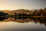
- Campsite by Wonnangatta River on The Viking Circuit. Photo Dzung Nguyen
- WonnangR.jpg (165.92 KiB) Viewed 28015 times
-
dplanet - Phyllocladus aspleniifolius
- Posts: 569
- Joined: Thu 04 Oct, 2007 8:21 pm
- Location: Ormond-Caulfield, Melbourne
- Region: Victoria
- Gender: Female
Re: Mt HOWITT
![]() by DB24 » Thu 18 Oct, 2012 10:06 am
by DB24 » Thu 18 Oct, 2012 10:06 am
Cheers
- DB24
- Nothofagus gunnii
- Posts: 41
- Joined: Thu 23 Feb, 2012 3:07 pm
- Region: Victoria
- Gender: Male
Re: Mt HOWITT
![]() by wildernesswanderer » Thu 18 Oct, 2012 5:26 pm
by wildernesswanderer » Thu 18 Oct, 2012 5:26 pm
-
wildernesswanderer - Athrotaxis cupressoides
- Posts: 322
- Joined: Sun 19 Aug, 2012 8:28 pm
- Location: Melbourne Australia
- Region: Victoria
- Gender: Male
Re: Mt HOWITT
![]() by north-north-west » Thu 18 Oct, 2012 5:56 pm
by north-north-west » Thu 18 Oct, 2012 5:56 pm
DB24 wrote:I'm thinking of going back up here for the cup long weekend. Looking at driving up the Mt Buller way and doing a 3 day walk that involves the crosscut spur. Any recommendation on a route? How is the road to the upper Howqua road campground for a 2WD car?
Unless they've changed the dates, you can't get to the Upper Howqua Camp until December. Bluff Link Road is currently impassable from just below the 16Mile Jeep Track turnoff, and the Stirling Circuit Road is usually closed through November to allow for roadworks. Check with VicParks first in case they've changed the opening date.
Once the road is open, however, it is usually 2WDable, although it can be very slow going as the steeper upper section of Bindaree Rd is prone to corrugations and washouts.
As for your walk, my favourite route is up Helicopter Spur, over Magdala and Big Hill to Howitt, along the Crosscut to Buggery and down Queen's Spur. Or you can descend earlier, via Stanley's Name Spur, which is the side track just before the high point of the Crosscut. Or you can do it in reverse, with a sidetrip to Speculation and descending Howitt Spur from Howitt West Peak.
-
north-north-west - Lagarostrobos franklinii
- Posts: 15412
- Joined: Thu 14 May, 2009 7:36 pm
- Location: The Asylum
- ASSOCIATED ORGANISATIONS: Social Misfits Anonymous
- Region: Tasmania
Re: Mt HOWITT
![]() by north-north-west » Thu 18 Oct, 2012 5:58 pm
by north-north-west » Thu 18 Oct, 2012 5:58 pm
wildernesswanderer wrote:I'm going up this way around the 22nd December, if your at the springs, how long does it take to walk to Mt Spec across the cross cut, I seem to read about half a day, is this correct.
It depends. If you're like me and spend most of your time lollgagging at the views, taking photos and communing with the Wedgies, it can take a full day. But it's really just a half day walk.
-
north-north-west - Lagarostrobos franklinii
- Posts: 15412
- Joined: Thu 14 May, 2009 7:36 pm
- Location: The Asylum
- ASSOCIATED ORGANISATIONS: Social Misfits Anonymous
- Region: Tasmania
Re: Mt HOWITT
![]() by wildernesswanderer » Thu 18 Oct, 2012 6:10 pm
by wildernesswanderer » Thu 18 Oct, 2012 6:10 pm
-
wildernesswanderer - Athrotaxis cupressoides
- Posts: 322
- Joined: Sun 19 Aug, 2012 8:28 pm
- Location: Melbourne Australia
- Region: Victoria
- Gender: Male
Re: Mt HOWITT
![]() by madmacca » Fri 19 Oct, 2012 8:51 am
by madmacca » Fri 19 Oct, 2012 8:51 am
- madmacca
- Phyllocladus aspleniifolius
- Posts: 514
- Joined: Fri 14 Oct, 2011 11:18 pm
- Region: Victoria
- Gender: Male
Re: Mt HOWITT
![]() by Kinsayder » Mon 22 Oct, 2012 9:00 pm
by Kinsayder » Mon 22 Oct, 2012 9:00 pm
-
Kinsayder - Athrotaxis cupressoides
- Posts: 361
- Joined: Tue 15 Nov, 2011 8:23 am
- Region: Victoria
Re: Mt HOWITT
![]() by byrnesy8 » Mon 22 Oct, 2012 9:10 pm
by byrnesy8 » Mon 22 Oct, 2012 9:10 pm
- byrnesy8
- Nothofagus gunnii
- Posts: 43
- Joined: Sat 27 Mar, 2010 11:56 am
- Region: Victoria
- Gender: Male
Re: Mt HOWITT
![]() by Out_Walking » Tue 23 Oct, 2012 7:11 am
by Out_Walking » Tue 23 Oct, 2012 7:11 am
Is the Helicopter Spur really that difficult to discern?
I was up there earlier this year and found the route up was easy to find. I took the old vehicle track (a bit overgrown, but not too bad) that began just behind the toilet block in the Upper Howqua Camping Area. Once on that old road it's a matter of just heading up and tackling the three rock bands. I hate advertising blog posts on here, but I did a post on the Helicopter Spur which might help if you're interested.
http://www.hikingfiasco.com/2012/02/hel ... indow.html
- Out_Walking
- Atherosperma moschatum
- Posts: 77
- Joined: Sun 18 Jul, 2010 9:59 pm
- Region: Victoria
- Gender: Male
Re: Mt HOWITT
![]() by Kinsayder » Tue 23 Oct, 2012 10:20 am
by Kinsayder » Tue 23 Oct, 2012 10:20 am
I have also just noticed the Parks Victoria website states "Bluff Link Road and the Upper Howqua Camping Area in the Alpine National Park will remain closed after seasonal closure openings on 1 November 2012 until flood recovery works are completed." That appears to me to be a no go then, am I reading it right? I hope not!
I'm just reading your blog now, Greg. Great stuff. Some fantastic photographs, great topic and a nice turn of phrase. Very readable! Thank you.
-
Kinsayder - Athrotaxis cupressoides
- Posts: 361
- Joined: Tue 15 Nov, 2011 8:23 am
- Region: Victoria
Who is online
Users browsing this forum: No registered users and 12 guests