I had seen descriptions and some photos on this site, and had begun to gather appropriate maps and reports.
As always - there were plans made and then altered at last minute and then changed on the run.
It is always good to have thought about alternatives and escape routes.
So on the 17th we drove from Canberra to Lake Cobbler in a small 2WD.
The road up was just managable, testing our car on the longish steep part at the end but being fine at the pool of water at the lake outlet.
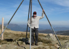
We took 2 hours hiking up to Mt Cobbler. Seeing some folk already on top of the main peak, we found a nice spot for our tents just down from the secondary peak.
It was a beautiful night to watch the sun setting from the tops.
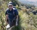
Proceeding down the small cliff line and scrambling up the connecting spine to the very top we met the school group who had set up tents there. They said that above 200 kids were distributed right across the ranges doing walks.
We did happen to cross paths with a couple of these groups over the following days.
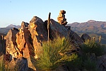
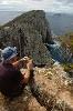
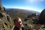
I think this spot was perhaps the standout of our entire walk. Relatively easy access to a marvellous grandstand and lovely weather to assist.
To the north lay the Buffalo Plateau with its granite tors
SE was Mt Buller and Stirling, and to the south was the grand arc of the ridgeline running from Koonika through Spec, Crosscut Saw, Howitt, etc to the Bluff.
I had fun that night with a small but powerful bike light mixing brief exposures of the trees with a background of stars.
Up early the next day to catch the sunrise. The sky was clear and there were valleys of mist far below - magical.
- Panorama of Lake Cobbler
- From Cobbler looking south along the arc of mountains. Koonika through Howitt to the Bluff
- Stars amongst the Snow Gums
- Fun with torch light - our tent site.
- Pre dawn light to the east