Hi everyone,
I'm looking at walking from Upper Jameison hut to Mt Clear as an overnighter next week. I'm wondering which site is the best spot for camping at water availability. I would prefer not to drop pack too early as I am after some extended pack carrying training - it's been far too long between trips.
Cheers,
Pazzar
Mt McDonald-Mt Clear camping
Forum rules
Victoria specific bushwalking discussion. Please avoid publishing details of access to sensitive areas with no tracks.
Victoria specific bushwalking discussion. Please avoid publishing details of access to sensitive areas with no tracks.
28 posts
• Page 1 of 1
Mt McDonald-Mt Clear camping
![]() by pazzar » Sat 11 Oct, 2014 2:31 pm
by pazzar » Sat 11 Oct, 2014 2:31 pm
"It's not what you look at that matters, it's what you see."
-
pazzar - Lagarostrobos franklinii

- Posts: 2657
- Joined: Thu 09 Jul, 2009 5:22 pm
- Location: Hobart
- Region: Tasmania
- Gender: Male
Re: Mt McDonald-Mt Clear camping
![]() by rocketrm2 » Sat 11 Oct, 2014 3:02 pm
by rocketrm2 » Sat 11 Oct, 2014 3:02 pm
Not sure which route you take. As it was getting dark when I was crossing Mt Clear, I bolted across the summit wanting to get to lower ground in daylight. Around the summit with Snow gums, meadows and pools of clear water would make for good camping. At the northern base of MT Clear there is a saddle, nice place to camp, with a spring nearby. I have camped there twice
- rocketrm2
- Athrotaxis cupressoides

- Posts: 131
- Joined: Wed 01 Jan, 2014 7:02 pm
- Region: Victoria
- Gender: Male
Re: Mt McDonald-Mt Clear camping
![]() by north-north-west » Mon 13 Oct, 2014 9:29 am
by north-north-west » Mon 13 Oct, 2014 9:29 am
There are soaks at the saddle just below the Nobs (it's worth a detour to the southern highpoint), and usually some water in small pools just past the saddle between High Cone and Square Top (the pad passes down and then up over terraces - I've always camped on what I think is the second terrace on the eastern side). This time of the year there may be one or two small snowdrifts still in the sheltered spots, but you can't depend on that. Only other water on the high route (I assume you're returning via the old vehicle track that runs down the ridge east from Clear, back to Brocks Road) is the occasional unreliable small pool or soak on Clear itself, just north of the summit, or the soaks where the AAWT rejoins the MVO road to the north.
This was probably my favourite short loop in the Victorian Alps, MacDonald is a lovely little peak. It's worth heading out to it's west peak too, for the views.
This was probably my favourite short loop in the Victorian Alps, MacDonald is a lovely little peak. It's worth heading out to it's west peak too, for the views.
"Mit der Dummheit kämpfen Götter selbst vergebens."
-

north-north-west - Lagarostrobos franklinii
- Posts: 15412
- Joined: Thu 14 May, 2009 7:36 pm
- Location: The Asylum
- ASSOCIATED ORGANISATIONS: Social Misfits Anonymous
- Region: Tasmania
Re: Mt McDonald-Mt Clear camping
![]() by jford » Mon 13 Oct, 2014 11:55 am
by jford » Mon 13 Oct, 2014 11:55 am
The saddle to the north of Mt Clear, mentioned by rocketrm2 above, is a great campsite. Head left off the AAWT after the north-east descent from Mt Clear and stop in the saddle. A track off to the south from the saddle sidles around to the water point, a creek coming off the north face of the mountain.
Solvitur Ambulando: It is solved by walking. (St Augustine, attr.)
- jford
- Atherosperma moschatum

- Posts: 54
- Joined: Sat 14 Jul, 2012 8:53 pm
- Location: Melbourne
- Region: Victoria
- Gender: Male
Re: Mt McDonald-Mt Clear camping
![]() by pazzar » Mon 13 Oct, 2014 6:02 pm
by pazzar » Mon 13 Oct, 2014 6:02 pm
What sort of time should I be expecting NNW? Easy enough to do the circuit in 2 days? I was thinking of returning via the ridge to avoid lots of road walking.
"It's not what you look at that matters, it's what you see."
-
pazzar - Lagarostrobos franklinii
- Posts: 2657
- Joined: Thu 09 Jul, 2009 5:22 pm
- Location: Hobart
- Region: Tasmania
- Gender: Male
Re: Mt McDonald-Mt Clear camping
![]() by north-north-west » Tue 14 Oct, 2014 6:00 am
by north-north-west » Tue 14 Oct, 2014 6:00 am
Yeah, two days would be a doddle for you. That's what I've always done, driving up the night before and starting the walk as early as possible. Camping where I did meant I'd be back at the car by mid-afternoon, without any hurry.
I don't know whether the old route up MacDonald's north face has had any work recently - last couple of times I was there some of it was a bit overgrown, particularly around the saddle where the ancient 4wd track ended. Once you're up a bit it's easy enough to pick the route up over the terraces, and once on top the AAWT is marked and the pad easy to follow.
The turn off from MacDonald's ridge is marked with a couple of cairns, the route up to the Nobs north summit has an AAWT marker on a low post, and the rest doesn't really need markers unless the weather is horrific. You can pick your options, staying a bit lower and sidling the higher points (High Cone and Square Top) or stick to the high line (which I usually did, as the views are pretty good), depending on weather, time and inclinations. MacDonald, Nobs, High Cone and Clear all have good views, while Square Top is a bit treed in and is one of those indeterminate summits anyway. If you do decide to go up it, the drop down to the saddle with Clear is steep and a bit loose and can be missed in bad weather.
The MVO east along Mt Clear Ridge gets about two vehicles per year, so it's not exactly your standard road bash. A lot of open grassy ground with a good wildflower display at the right times. Only place it turns into a drag is the zig zag down to the creek. Trying to go cross country could be interesting as the regrowth might still be a bit awkward.
"Mit der Dummheit kämpfen Götter selbst vergebens."
-
north-north-west - Lagarostrobos franklinii
- Posts: 15412
- Joined: Thu 14 May, 2009 7:36 pm
- Location: The Asylum
- ASSOCIATED ORGANISATIONS: Social Misfits Anonymous
- Region: Tasmania
Re: Mt McDonald-Mt Clear camping
![]() by pazzar » Tue 14 Oct, 2014 10:56 am
by pazzar » Tue 14 Oct, 2014 10:56 am
Thanks - I'll see how it goes. I should move pretty quick along the ridge, Hopefully the road is passable. I'm heading up to Sheepyard Flat tonight to get an early start. Weather not looking great, but hopefully the weatherman is wrong.
A quick google search indicates that some track work has been done over the summer around the Nobs and Mt McDonald.
A quick google search indicates that some track work has been done over the summer around the Nobs and Mt McDonald.
"It's not what you look at that matters, it's what you see."
-
pazzar - Lagarostrobos franklinii
- Posts: 2657
- Joined: Thu 09 Jul, 2009 5:22 pm
- Location: Hobart
- Region: Tasmania
- Gender: Male
Re: Mt McDonald-Mt Clear camping
![]() by Travis22 » Tue 14 Oct, 2014 11:06 am
by Travis22 » Tue 14 Oct, 2014 11:06 am
Fingers crossed the weather is kind to you Pazzar, I'd love to see some photos from your trip when you get back. I've been over Mt Mcdonald and thoroughly enjoyed that hike.
Travis.
Travis.
-

Travis22 - Phyllocladus aspleniifolius

- Posts: 685
- Joined: Thu 15 Nov, 2012 7:11 pm
- Region: Victoria
- Gender: Male
Re: Mt McDonald-Mt Clear camping
![]() by north-north-west » Tue 14 Oct, 2014 7:20 pm
by north-north-west » Tue 14 Oct, 2014 7:20 pm
Yeah, I'd also like to hear how it goes and see the photos. Big Mac is possibly my favourite Victorian summit.
"Mit der Dummheit kämpfen Götter selbst vergebens."
-
north-north-west - Lagarostrobos franklinii
- Posts: 15412
- Joined: Thu 14 May, 2009 7:36 pm
- Location: The Asylum
- ASSOCIATED ORGANISATIONS: Social Misfits Anonymous
- Region: Tasmania
Re: Mt McDonald-Mt Clear camping
![]() by pazzar » Wed 15 Oct, 2014 3:17 pm
by pazzar » Wed 15 Oct, 2014 3:17 pm
Well it beat me this time! Rocked up last night to beautiful conditions, woke up this morning to the sun shining, drove over 8 Mile Gap and lost all visibility. It was clearly snowing on the Bluff. I decided not to go on up there in those conditions - wouldn't have been enjoyable at all. Will head back up in a couple of weeks for another crack.
It looks like the road has been graded recently, at least as far as 8 Mile Gap. There was a bit of carnage on the road after that point. I'm pretty sure I almost ran out of fuel on the way back too - I must remember to top up in Mansfield next time - it's a fair drive in there.
It looks like the road has been graded recently, at least as far as 8 Mile Gap. There was a bit of carnage on the road after that point. I'm pretty sure I almost ran out of fuel on the way back too - I must remember to top up in Mansfield next time - it's a fair drive in there.
"It's not what you look at that matters, it's what you see."
-
pazzar - Lagarostrobos franklinii
- Posts: 2657
- Joined: Thu 09 Jul, 2009 5:22 pm
- Location: Hobart
- Region: Tasmania
- Gender: Male
Re: Mt McDonald-Mt Clear camping
![]() by Travis22 » Wed 15 Oct, 2014 10:07 pm
by Travis22 » Wed 15 Oct, 2014 10:07 pm
Ah! What a bugger although I'm sure it was still better then staying home / at work!
Pretty insane weather ATM, would you believe 'they' are saying 31degC next week (Tues) in Melb!
Travis.
Pretty insane weather ATM, would you believe 'they' are saying 31degC next week (Tues) in Melb!
Travis.
-
Travis22 - Phyllocladus aspleniifolius
- Posts: 685
- Joined: Thu 15 Nov, 2012 7:11 pm
- Region: Victoria
- Gender: Male
Re: Mt McDonald-Mt Clear camping
![]() by pazzar » Wed 15 Oct, 2014 10:18 pm
by pazzar » Wed 15 Oct, 2014 10:18 pm
Not a cloud on Buller though, only a few kms away! And I sat out in the sun for lunch in Mansfield. Strange how a few valleys changes things.
Got Sunday off - I'll find something to climb while the weather is nice!
Got Sunday off - I'll find something to climb while the weather is nice!
"It's not what you look at that matters, it's what you see."
-
pazzar - Lagarostrobos franklinii
- Posts: 2657
- Joined: Thu 09 Jul, 2009 5:22 pm
- Location: Hobart
- Region: Tasmania
- Gender: Male
Re: Mt McDonald-Mt Clear camping
![]() by neilmny » Thu 16 Oct, 2014 6:26 am
by neilmny » Thu 16 Oct, 2014 6:26 am
If your in that neighbourhood and need an alternative option, Mt Stirling is always a nice walk.
-
neilmny - Lagarostrobos franklinii
- Posts: 2576
- Joined: Fri 03 Aug, 2012 11:19 am
- Region: Victoria
- Gender: Male
Re: Mt McDonald-Mt Clear camping
![]() by JulianS » Sun 13 Sep, 2015 11:21 pm
by JulianS » Sun 13 Sep, 2015 11:21 pm
Hi all,
I’ve been eyeing off this walk for a weekender some time before the end of the year. I’d like to follow up on the comments above regarding the state of the track.
I was in the area just for the day last weekend, and – for a bit of an appetiser/research – thought I’d check out the route up McDonald from Low Saddle Road. As a first time visitor though I couldn’t actually locate the track. I found what I thought was ‘a’ track, but – since it was very overgrown and essentially imperceptible within about 10 min – wasn’t sure if it was ‘the’ track. There were no ribbons, markers, etc that I could see.
Anyway – I was just wondering if anyone knows whether this route (Upper Jamieson Hut – Low Saddle Road – Mt McDonald) has indeed had some work done since the fires (i.e. I was just in the wrong place?) or if it’s still a bush bash?
Many thanks
- JulianS
- Atherosperma moschatum
- Posts: 50
- Joined: Tue 13 Aug, 2013 9:15 pm
- Region: Victoria
- Gender: Male
Re: Mt McDonald-Mt Clear camping
![]() by GBW » Mon 14 Sep, 2015 12:48 am
by GBW » Mon 14 Sep, 2015 12:48 am
If you continued on from Low Saddle up Mt Sunday rd around a hairpin turn for a km or so you should the turnoff which is the start of the route up to Mt MacDonald. Don't expect the path to be recognizable all the way...just keep going north up along the crest of the rocky ridge. Its pretty hard to lose your way unless for some reason you deviate off the side.
I just realized you said Low Saddle Rd...never mind.
I just realized you said Low Saddle Rd...never mind.
"If you wish to make an apple pie from scratch, you must first invent the universe"
-

GBW - Athrotaxis selaginoides

- Posts: 1175
- Joined: Fri 02 May, 2014 9:03 am
- Location: Melbourne
- Region: Victoria
- Gender: Male
Re: Mt McDonald-Mt Clear camping
![]() by neilmny » Mon 14 Sep, 2015 6:05 am
by neilmny » Mon 14 Sep, 2015 6:05 am
JulianS wrote:........... – I was just wondering if anyone knows whether this route (Upper Jamieson Hut – Low Saddle Road – Mt McDonald) has indeed had some work done since the fires (i.e. I was just in the wrong place?) or if it’s still a bush bash?
Many thanks
I was at Upper Jamieson Hut earlier this year and was looking for the track from the hut to Low Saddle Rd. and couldn't find anything.
There were a few possibilities or what looked like posibilities but they petered out very quickly to nothing. Mind you I didn't spend hours on the task.
From Low Saddle Rd. to Mt. McDonald I can't answer but it is shown on several GPS maps, Oztoppo, Toppo Aus V3 and OSM.
Interestingly the section from the hut to Low Saddle Rd. is shown on Oztoppo and Toppo Aus. but not OSM.
The section from Low Saddle Rd. to Mt. McDonald is named "Mt. McDonald Walking Track" on OSM only. It is just "path" on the others.
Not much help I know but hopefully some food for thought.
-
neilmny - Lagarostrobos franklinii
- Posts: 2576
- Joined: Fri 03 Aug, 2012 11:19 am
- Region: Victoria
- Gender: Male
Re: Mt McDonald-Mt Clear camping
![]() by north-north-west » Mon 14 Sep, 2015 8:23 am
by north-north-west » Mon 14 Sep, 2015 8:23 am
There were two routes from Low Saddle Rd. The first is using the old straight line track from the hut from where it crosses the road. The other is to park around . . . ummm, I'm not sure of the distance, but it's it's a pretty obvious spot on the northern side of the road (edit) about two km from the bridge, a very large turnout on a corner with a couple of big trees near its edges. You follow a pad up an old dozer cut and then swing left when that reaches the old vehicle track that the route from the hut uses.
I may be able to supple a GPX file for it . . . I think I have one that follows the route properly, although it might go a bit astray in one or two of the more overgrown spots . . .
(edit) Yeah, I have three GPX files that follow that second route, and the MacDonald-Clear circuit one seem to be pretty well on line.
Detours are mostly scrambling over fallen trees.
As far as I know, most of the trackwork done on the north face route was by Timbertop as it is (or was) one of their usual walks. You could also check with the Ranger at Mansfield to see if they've done anything there recently.
"Mit der Dummheit kämpfen Götter selbst vergebens."
-
north-north-west - Lagarostrobos franklinii
- Posts: 15412
- Joined: Thu 14 May, 2009 7:36 pm
- Location: The Asylum
- ASSOCIATED ORGANISATIONS: Social Misfits Anonymous
- Region: Tasmania
Re: Mt McDonald-Mt Clear camping
![]() by JulianS » Tue 15 Sep, 2015 10:42 am
by JulianS » Tue 15 Sep, 2015 10:42 am
All replies appreciated – thank you.
Neil – interesting to hear of your experience starting from the hut. I’d wondered whether it might’ve been easier picking it up from there. I must admit I’m inexperienced when it comes to GPS maps, so not sure what to make of those differences. Out of interest – of those map sources you mentioned, do you favour one over the others?
NNW – based on your description of the turnout / track and my own examination of the map I’m reasonably confident that I was indeed on the second of those routes you describe. There was clearly a point where the “track” swung left – presumably this was the junction with the old vehicle track. Not that it resembled a vehicle track in any way given how overgrown it was! It was not long after this left turn that I couldn’t discern anything to follow and decided to turn around.
Despite the overgrowth, I’d hope it would become a bit sparser with more elevation and I’m still keen to have a go at this circuit. I don’t own a GPS device as yet, though long been thinking about getting one. If I do before attempting this I’ll PM you regarding the GPX file (thank you very much for this offer). In any case, would you strongly advocate using one for this route? (I’m a relatively experienced walker, but not off track). My impression is that the navigation should be fairly straightforward in this case given how the route follows the spur.
Thanks again.
PS - I will also follow up with the ranger, as suggested.
- JulianS
- Atherosperma moschatum
- Posts: 50
- Joined: Tue 13 Aug, 2013 9:15 pm
- Region: Victoria
- Gender: Male
Re: Mt McDonald-Mt Clear camping
![]() by neilmny » Tue 15 Sep, 2015 12:42 pm
by neilmny » Tue 15 Sep, 2015 12:42 pm
JulianS wrote:........Neil – interesting to hear of your experience starting from the hut. I’d wondered whether it might’ve been easier picking it up from there. I must admit I’m inexperienced when it comes to GPS maps, so not sure what to make of those differences. Out of interest – of those map sources you mentioned, do you favour one over the others?.........
I've come to the conclusion that they are all worth having.
Garmin Toppo is great because you can get a 3D profile of a planned walk/track.
Oztoppo is good for the access roads particularly 4WD tracks.
OSM is my favourite and I've found it to be the most accurate where someone has gone to the trouble of adding tracks etc. to the OSM data base. Having said that there is a fair bit missing here and there as well. Adding to or updating OSM Is something I've been doing myself (in non sensitive areas) and is a lot of fun once you work out how to go about it. A couple of other BW members ENT and andrewp have links to their own OSM maps that they have made. Look up ENT world on this forum to find out more.
-
neilmny - Lagarostrobos franklinii
- Posts: 2576
- Joined: Fri 03 Aug, 2012 11:19 am
- Region: Victoria
- Gender: Male
Re: Mt McDonald-Mt Clear camping
![]() by north-north-west » Mon 28 Sep, 2015 6:54 pm
by north-north-west » Mon 28 Sep, 2015 6:54 pm
JulianS wrote:NNW – based on your description of the turnout / track and my own examination of the map I’m reasonably confident that I was indeed on the second of those routes you describe. There was clearly a point where the “track” swung left – presumably this was the junction with the old vehicle track. Not that it resembled a vehicle track in any way given how overgrown it was! It was not long after this left turn that I couldn’t discern anything to follow and decided to turn around.
Despite the overgrowth, I’d hope it would become a bit sparser with more elevation and I’m still keen to have a go at this circuit. I don’t own a GPS device as yet, though long been thinking about getting one. If I do before attempting this I’ll PM you regarding the GPX file (thank you very much for this offer). In any case, would you strongly advocate using one for this route? (I’m a relatively experienced walker, but not off track). My impression is that the navigation should be fairly straightforward in this case given how the route follows the spur.
It is a pretty obvious starting point, it's just the the regrowth that is an issue. A pity, as it's a brilliant walk.
The lower part of the route does wander a bit as it traverses a bit of the hillside to pick up the right spur. Climbs, turns, then drops down into a saddle before rising again. Once you're on the spur proper and climbing, it's pretty easy nav. If you don't know the route and aren't used to scrub-bashing, a GPS would make it a lot easier.
"Mit der Dummheit kämpfen Götter selbst vergebens."
-
north-north-west - Lagarostrobos franklinii
- Posts: 15412
- Joined: Thu 14 May, 2009 7:36 pm
- Location: The Asylum
- ASSOCIATED ORGANISATIONS: Social Misfits Anonymous
- Region: Tasmania
Re: Mt McDonald-Mt Clear camping
![]() by JulianS » Sun 25 Oct, 2015 12:23 pm
by JulianS » Sun 25 Oct, 2015 12:23 pm
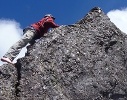
Last weekend I finally got the opportunity to head back out to the Howqua area and attempt this route up the northern aspect of Mt McDonald. Had been waiting for a weekend with a good forecast for a while and thankfully the weather didn’t disappoint. The walk itself was alright too ;- )
Since this was my first go at something ‘off track’ (though I probably cant call it that – it’s mapped after all) I’ve got nothing to compare to in terms of difficulty/degree of bush-bashing/etc. I guess since I expected a pretty hard slog, I found it to be fairly manageable overall. The density varied quite a bit – ie some areas with thick regrowth; elsewhere it really opened out into good-sized clearings. A couple of places required detours around lots of fallen trees.
Since the old track is essentially indistinguishable, navigation was required the entire route (which has a few twists and turns). In a few places I thought I saw remnants of the former 4wd track; i.e. where it had been cut into the hillside or when there were narrow ‘tunnels’ in the regrowth. However, you certainly can’t rely on these to find your way. I used the Osmand app on my phone (OSM map?) – to regularly check that I wasn’t deviating from the route (labelled ‘Mt McDonald Walking Track’ – as described by Neil in a post above). However, Osmand only showed one of the two routes from Low Saddle Road (per NNW post above) – ie the one that follows the alignment from UJH. I instead started from a more eastern point on Low Saddle Road where there is a short track that heads south-west (shown on SV map, but not Osmand) until it intersects the other route.
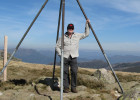
It think it took me about 80 min to walk from Low Saddle Rd to the deeper 2nd saddle just before the start of the main climb. The bush in the section initially heading up from this saddle is the most dense imo and it’s not until you get to a decent elevation / rockier ground that there’s any relief. Heading up the spur was more challenging than I expected actually, involving climbing up/over some steep rocky sections. Good fun though, and once I did get a bit of height and the views started to emerge I slowed down a lot - brilliant scenery. In fact I think it took me about 2 and a half hours from the 2nd saddle to the summit, which obviously could’ve/should’ve been a lot shorter if I hadn’t kept stopping / taking photos etc. Then the summit itself was something else altogether – amazing views in every direction (as many others on this forum have described). I spent quite a bit of time up there, so it was late afternoon by the time I headed off along the AAWT toward the Nobs. Was a great time of day to be walking this ridge, although it took longer than I expected and I didn’t reach my eventual campsite – a spot off the 4wd track that connects the AAWT between McDonald / Nobs – until it was almost dark (in retrospect I faffed around on McDonald for too long).
Next day I had limited time, so returned to the car via Nobs track / Brocks Road. Regretted not being able to further explore the Nobs / High Cone / Clear etc but will just have to return another time for that!
Overall – was a really rewarding walk and it’s encouraged me to try some more undefined routes and/or “real” off track stuff. I didn’t see anyone else the entire 2 days – even at Seven Mile Flat where I car camped the night before starting. I imagine the whole area will see a lot more action from Cup weekend onwards though.
One final important point is that the area’s very dry. Im glad I carried 6L from the start as the only water I came across (which is to say that I didn’t actively look for it) was a few muddy/stagnant pools at random points along the Nobs 4wd track. Wasn’t keen on drinking from these, even with tablets, so I just collected some for emergency use knowing that the next day I’d be able to refill after getting back down into the valley (Clear Creek / Jamieson River).
A few photos from the trip below. First one's a pic of McDonald taken earlier this year from somewhere near Eagle Peaks - it was this that had really drawn me toward attempting the walk in the first place.
Since this was my first go at something ‘off track’ (though I probably cant call it that – it’s mapped after all) I’ve got nothing to compare to in terms of difficulty/degree of bush-bashing/etc. I guess since I expected a pretty hard slog, I found it to be fairly manageable overall. The density varied quite a bit – ie some areas with thick regrowth; elsewhere it really opened out into good-sized clearings. A couple of places required detours around lots of fallen trees.
Since the old track is essentially indistinguishable, navigation was required the entire route (which has a few twists and turns). In a few places I thought I saw remnants of the former 4wd track; i.e. where it had been cut into the hillside or when there were narrow ‘tunnels’ in the regrowth. However, you certainly can’t rely on these to find your way. I used the Osmand app on my phone (OSM map?) – to regularly check that I wasn’t deviating from the route (labelled ‘Mt McDonald Walking Track’ – as described by Neil in a post above). However, Osmand only showed one of the two routes from Low Saddle Road (per NNW post above) – ie the one that follows the alignment from UJH. I instead started from a more eastern point on Low Saddle Road where there is a short track that heads south-west (shown on SV map, but not Osmand) until it intersects the other route.
It think it took me about 80 min to walk from Low Saddle Rd to the deeper 2nd saddle just before the start of the main climb. The bush in the section initially heading up from this saddle is the most dense imo and it’s not until you get to a decent elevation / rockier ground that there’s any relief. Heading up the spur was more challenging than I expected actually, involving climbing up/over some steep rocky sections. Good fun though, and once I did get a bit of height and the views started to emerge I slowed down a lot - brilliant scenery. In fact I think it took me about 2 and a half hours from the 2nd saddle to the summit, which obviously could’ve/should’ve been a lot shorter if I hadn’t kept stopping / taking photos etc. Then the summit itself was something else altogether – amazing views in every direction (as many others on this forum have described). I spent quite a bit of time up there, so it was late afternoon by the time I headed off along the AAWT toward the Nobs. Was a great time of day to be walking this ridge, although it took longer than I expected and I didn’t reach my eventual campsite – a spot off the 4wd track that connects the AAWT between McDonald / Nobs – until it was almost dark (in retrospect I faffed around on McDonald for too long).
Next day I had limited time, so returned to the car via Nobs track / Brocks Road. Regretted not being able to further explore the Nobs / High Cone / Clear etc but will just have to return another time for that!
Overall – was a really rewarding walk and it’s encouraged me to try some more undefined routes and/or “real” off track stuff. I didn’t see anyone else the entire 2 days – even at Seven Mile Flat where I car camped the night before starting. I imagine the whole area will see a lot more action from Cup weekend onwards though.
One final important point is that the area’s very dry. Im glad I carried 6L from the start as the only water I came across (which is to say that I didn’t actively look for it) was a few muddy/stagnant pools at random points along the Nobs 4wd track. Wasn’t keen on drinking from these, even with tablets, so I just collected some for emergency use knowing that the next day I’d be able to refill after getting back down into the valley (Clear Creek / Jamieson River).
A few photos from the trip below. First one's a pic of McDonald taken earlier this year from somewhere near Eagle Peaks - it was this that had really drawn me toward attempting the walk in the first place.
- Mt McDonald viewed from a spot near Eagle Peaks
- MtMcD.jpg (21.77 KiB) Viewed 18772 times
- Lower section after leaving Low Saddle Rd
- LwrSec.jpg (84.8 KiB) Viewed 18772 times
- View from the spur
- spur1.jpg (63.42 KiB) Viewed 18772 times
- View from the spur
- spur2.jpg (44.74 KiB) Viewed 18772 times
- Summit - south or south west(?) aspect
- summit2.jpg (52 KiB) Viewed 18772 times
- Summit - looking north toward Buller / the Bluff
- summit.jpg (38.74 KiB) Viewed 18772 times
- JulianS
- Atherosperma moschatum
- Posts: 50
- Joined: Tue 13 Aug, 2013 9:15 pm
- Region: Victoria
- Gender: Male
Re: Mt McDonald-Mt Clear camping
![]() by wildlight » Sun 25 Oct, 2015 12:41 pm
by wildlight » Sun 25 Oct, 2015 12:41 pm
Mate, an awesome writeup and excellent photos! I take my hat off to you. Thanks for taking the time to do this.
Mac is an amazing mountain, especially at sunset and sunrise, in clear conditions with wildflowers.
Now- 2.5 hours from second saddle to summit? I would take twice that. Kudos to you for having the smarts to take 6 liters of water, the sun can really bake up there. There is a good source down south along the fire track once you come of "Mac", but it's a question of: "with the energy you use walking down the hill and back up to get the water- wouldn't you have been better off just carrying it from the start and covering less distance?"
Am very keen to read of your trip on the rest of the circuit, and see more photos.
cheers
WildLight
**edited a typo, auto-prompt-spell simply has no clue.
- wildlight
- Athrotaxis cupressoides
- Posts: 212
- Joined: Tue 24 Mar, 2009 2:03 pm
Re: Mt McDonald-Mt Clear camping
![]() by neilmny » Sun 25 Oct, 2015 4:21 pm
by neilmny » Sun 25 Oct, 2015 4:21 pm
Nice work Julian, thanks for posting.
-
neilmny - Lagarostrobos franklinii
- Posts: 2576
- Joined: Fri 03 Aug, 2012 11:19 am
- Region: Victoria
- Gender: Male
Re: Mt McDonald-Mt Clear camping
![]() by GBW » Sun 25 Oct, 2015 5:07 pm
by GBW » Sun 25 Oct, 2015 5:07 pm
Thanks Julian, nice pics and looks like a perfect day for it. We were looking down there on our visit trying to figure out where the route came up from Low Saddle rd.
"If you wish to make an apple pie from scratch, you must first invent the universe"
-
GBW - Athrotaxis selaginoides
- Posts: 1175
- Joined: Fri 02 May, 2014 9:03 am
- Location: Melbourne
- Region: Victoria
- Gender: Male
Re: Mt McDonald-Mt Clear camping
![]() by JulianS » Mon 26 Oct, 2015 6:34 am
by JulianS » Mon 26 Oct, 2015 6:34 am
Thanks everyone for the kind words. Yes, I’m very much looking forward to getting back out to see more of this area – hopefully sooner rather than later.
GBW here is a pic of the start of the route from Low Saddle Rd. As I mentioned in a previous post in this topic, I’d found it during a previous visit to the area (albeit without being sure at the time that it was the right spot).
GBW here is a pic of the start of the route from Low Saddle Rd. As I mentioned in a previous post in this topic, I’d found it during a previous visit to the area (albeit without being sure at the time that it was the right spot).
- LSR.jpg (78.2 KiB) Viewed 18678 times
- JulianS
- Atherosperma moschatum
- Posts: 50
- Joined: Tue 13 Aug, 2013 9:15 pm
- Region: Victoria
- Gender: Male
Re: Mt McDonald-Mt Clear camping
![]() by north-north-west » Mon 26 Oct, 2015 7:07 am
by north-north-west » Mon 26 Oct, 2015 7:07 am
Well done! Glad to hear the route is still viable. I recognise a couple of spots on the rocky terraces in those photos. They're incredibly beautiful when the wildflowers are blooming.
"Mit der Dummheit kämpfen Götter selbst vergebens."
-
north-north-west - Lagarostrobos franklinii
- Posts: 15412
- Joined: Thu 14 May, 2009 7:36 pm
- Location: The Asylum
- ASSOCIATED ORGANISATIONS: Social Misfits Anonymous
- Region: Tasmania
Re: Mt McDonald-Mt Clear camping
![]() by JulianS » Wed 28 Oct, 2015 8:35 am
by JulianS » Wed 28 Oct, 2015 8:35 am
Thanks north-north-west for your good info on this walk – not just the posts here but also under this topic: viewtopic.php?f=37&t=8396
Likewise WildLight for your posts in that other topic – very useful.
edit: forgot to ask a (silly?) question - any thoughts on best time of year for wildflowers in the high country? Just the summer months?
Likewise WildLight for your posts in that other topic – very useful.
edit: forgot to ask a (silly?) question - any thoughts on best time of year for wildflowers in the high country? Just the summer months?
- JulianS
- Atherosperma moschatum
- Posts: 50
- Joined: Tue 13 Aug, 2013 9:15 pm
- Region: Victoria
- Gender: Male
Re: Mt McDonald-Mt Clear camping
![]() by wildlight » Wed 28 Oct, 2015 10:42 am
by wildlight » Wed 28 Oct, 2015 10:42 am
Hamburger Hill (Mt McDonald) is a favourite of mine just between XMAS and New Year. Flowers are pumping at that time, especially in the area east of the summit for just over a kilometre before the spur swings south. Howitt et al are also great at that time, and the area around Arbuckle, Snowy Plains etc seems to happen a couple of weeks earlier.
Some amazing stuff in the lower altitudes right now, if you know where to look, think Southern Jamieson River catchment area.
You've timed your inquiry just ahead of the curve. The alps are showing off, for you to explore. Just keep posting the pics…!
With wildflowers, aspect and altitude play a big part- as do seasonal variations from year to year.
Cheers
WildLight
- wildlight
- Athrotaxis cupressoides
- Posts: 212
- Joined: Tue 24 Mar, 2009 2:03 pm
28 posts
• Page 1 of 1
Who is online
Users browsing this forum: No registered users and 10 guests