Mt HOWITT

Victoria specific bushwalking discussion.
Forum rules
Victoria specific bushwalking discussion. Please avoid publishing details of access to sensitive areas with no tracks.

Re: Mt HOWITT

Postby Out_Walking » Tue 23 Oct, 2012 1:35 pm

Bluff Link Road and the Upper Howqua Camping Area in the Alpine National Park will remain closed


Umm... I got to the Upper Howqua camping area via Telephone Box Junction near Mt Stirling. Then it was Circuit Road and finally Bindaree Road. Bindaree is potentially dodgy, so I'd probably check on that one, although I got my 2WD down there okay in February. Not sure about now after winter!

Upper Howqua camping area was closed when I was there as the road before the main camping area had been washed away. There was parking before that spot though and a few large open spaces which I camped in the night before.

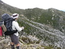
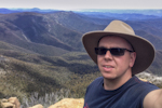
It's well worth it if you can get to tackle the Helicopter Spur, as it's a lot of fun. I was certainly intimidated by the rock bands from a distance, but once under them I found the way up quite easily. I detest the heat, so if I can make it up in summer I think anyone can :) I should have taken more water, but you've got Hellfire Creek for a top-up if you head across Mt Magdala.

Thanks for talking up the blog! Blogging feels like I'm talking to myself a lot of the time, so any kind words are very appreciated!
Out_Walking
Atherosperma moschatum
 
Posts: 77
Joined: Sun 18 Jul, 2010 9:59 pm
Region: Victoria
Gender: Male

Re: Mt HOWITT

Postby dplanet » Tue 23 Oct, 2012 3:35 pm

Kinsayder wrote:Excellent. It sounds pretty doable. Is November pretty hot and dry for it? To say that I'm weak when it's hot would be a massive understatement.

I have also just noticed the Parks Victoria website states "Bluff Link Road and the Upper Howqua Camping Area in the Alpine National Park will remain closed after seasonal closure openings on 1 November 2012 until flood recovery works are completed." That appears to me to be a no go then, am I reading it right? I hope not!

I'm just reading your blog now, Greg. Great stuff. Some fantastic photographs, great topic and a nice turn of phrase. Very readable! Thank you.


+1 and hope weather will be kind for the Cup Day long weekend.
User avatar
dplanet
Phyllocladus aspleniifolius
 
Posts: 569
Joined: Thu 04 Oct, 2007 8:21 pm
Location: Ormond-Caulfield, Melbourne
Region: Victoria
Gender: Female

Re: Mt HOWITT

Postby DB24 » Thu 25 Oct, 2012 7:23 am

Out_Walking wrote:
Bluff Link Road and the Upper Howqua Camping Area in the Alpine National Park will remain closed


Umm... I got to the Upper Howqua camping area via Telephone Box Junction near Mt Stirling. Then it was Circuit Road and finally Bindaree Road. Bindaree is potentially dodgy, so I'd probably check on that one, although I got my 2WD down there okay in February. Not sure about now after winter!

Upper Howqua camping area was closed when I was there as the road before the main camping area had been washed away. There was parking before that spot though and a few large open spaces which I camped in the night before.


Any other comments on this? I'm thinking of getting to the Upper Howqua Camping Area via the above route on cup weekend. Doable? Cheers
DB24
Nothofagus gunnii
Nothofagus gunnii
 
Posts: 41
Joined: Thu 23 Feb, 2012 3:07 pm
Region: Victoria
Gender: Male

Re: Mt HOWITT

Postby madmacca » Thu 25 Oct, 2012 1:34 pm

Kinsayder,

I stayed at Upper Howqua at cup weekend last year - the bridges into the camping area were washed out preventing vehicle access. But the campsite itself was fine, and as a walk-in, I had the entire campsite to myself.

Bindaree Rd was fine, but as it will have been just opened, you will need to take it carefully.

Crosscut Saw is 1400-1600 metres - no way is it going to be hot at this altitude over Cup weekend. Howqua is lower (starts at 850m, but a fairly deep shaded valley.
madmacca
Phyllocladus aspleniifolius
 
Posts: 514
Joined: Fri 14 Oct, 2011 11:18 pm
Region: Victoria
Gender: Male

Re: Mt HOWITT

Postby Kinsayder » Thu 25 Oct, 2012 2:50 pm

Thanks, MM! I really appreciate some currency of information, it's really handy (hopefully for DB24 too). I'm not going up on the Cup weekend, probably around the 14th. I like to avoid people (not to suggest I'm anti-social, I just like what solitude I can find) so a nice midweek hike is always my ideal. Now, from memory (I'm at work...and map is at home) there is a small road that leads off of Bindaree Road that crosses the river and bang! you're at Upper Howqua. Is that the bridge you're referring to? Is it a tough cross?
User avatar
Kinsayder
Athrotaxis cupressoides
 
Posts: 361
Joined: Tue 15 Nov, 2011 8:23 am
Region: Victoria

Re: Mt HOWITT

Postby madmacca » Thu 25 Oct, 2012 8:57 pm

Yes, a short distance from Bindaree. From memory, there was one girder left on the old bridge (the other girder and deck had washed away), and I was able to walk across on that. But the Howqua River itself is probably only 9 inches deep if you had to walk across anyway.
madmacca
Phyllocladus aspleniifolius
 
Posts: 514
Joined: Fri 14 Oct, 2011 11:18 pm
Region: Victoria
Gender: Male

Re: Mt HOWITT

Postby Kinsayder » Fri 26 Oct, 2012 12:56 pm

Thanks again, MM. My wife gets a bit concerned with me heading off for days at a time with no contact, so those details probably fulfill my obligations somewhat to know what I'm doing.
User avatar
Kinsayder
Athrotaxis cupressoides
 
Posts: 361
Joined: Tue 15 Nov, 2011 8:23 am
Region: Victoria

Re: Mt HOWITT

Postby madmacca » Wed 07 Nov, 2012 4:17 pm

Just went through there again last weekend. Bindaree Rd is actually in good condition (better than Circuit Rd). No changes to Upper Howqua - still easy foot access, with ample parking on the N side of the river. I took Howitt Spur track, so can't tell you about Helicopter Spur.
madmacca
Phyllocladus aspleniifolius
 
Posts: 514
Joined: Fri 14 Oct, 2011 11:18 pm
Region: Victoria
Gender: Male

Re: Mt HOWITT

Postby andrewbish » Wed 07 Nov, 2012 10:07 pm

I got up there with wife and youngest daughter over Cup weekend too. Lots of cars in the Upper Howqua car park, but we found a spot across the river.

We did a circuit of Thorn Range, Stanley Name Spur, Queen Spur, Mt Buggery, CC Saw, Mt Howitt and Nt Howitt Spur. Very sore today!

We had to do some crazy bush bashing on the approach to Queen Spur - has anyone found a decent route on this section?
Twitter: @andrewbishxplor Blog: Trails & tracks
User avatar
andrewbish
Phyllocladus aspleniifolius
 
Posts: 781
Joined: Mon 03 Jan, 2011 7:08 pm
Location: Melbourne
Region: Victoria
Gender: Male

Re: Mt HOWITT

Postby north-north-west » Thu 08 Nov, 2012 6:12 pm

andrewbish wrote:We had to do some crazy bush bashing on the approach to Queen Spur - has anyone found a decent route on this section?


It was pretty open when I was last up that way, although that was a couple of years ago. I just followed the logging road until it crested the ridge and went straight up from there. The only issue was finding the road on the far side of one tight (dry) creek gully, but otherwise it was easy going. Is the regrowth really that bad?
"Mit der Dummheit kämpfen Götter selbst vergebens."
User avatar
north-north-west
Lagarostrobos franklinii
 
Posts: 15412
Joined: Thu 14 May, 2009 7:36 pm
Location: The Asylum
ASSOCIATED ORGANISATIONS: Social Misfits Anonymous
Region: Tasmania

Re: Mt HOWITT

Postby andrewbish » Thu 08 Nov, 2012 7:00 pm

north-north-west wrote:
andrewbish wrote:We had to do some crazy bush bashing on the approach to Queen Spur - has anyone found a decent route on this section?


It was pretty open when I was last up that way, although that was a couple of years ago. I just followed the logging road until it crested the ridge and went straight up from there. The only issue was finding the road on the far side of one tight (dry) creek gully, but otherwise it was easy going. Is the regrowth really that bad?


Hi NNW

I lost the road at the point where it turns sharply NW and begins to sidle up Queen Spur.

ImageUploadedByTapatalk1352365034.390486.jpg
ImageUploadedByTapatalk1352365034.390486.jpg (127.52 KiB) Viewed 19646 times
Twitter: @andrewbishxplor Blog: Trails & tracks
User avatar
andrewbish
Phyllocladus aspleniifolius
 
Posts: 781
Joined: Mon 03 Jan, 2011 7:08 pm
Location: Melbourne
Region: Victoria
Gender: Male

Re: Mt HOWITT

Postby ryantmalone » Thu 08 Nov, 2012 7:12 pm

Out_Walking wrote:
Is the Helicopter Spur really that difficult to discern?


I was up there earlier this year and found the route up was easy to find. I took the old vehicle track (a bit overgrown, but not too bad) that began just behind the toilet block in the Upper Howqua Camping Area. Once on that old road it's a matter of just heading up and tackling the three rock bands. I hate advertising blog posts on here, but I did a post on the Helicopter Spur which might help if you're interested.

http://www.hikingfiasco.com/2012/02/hel ... indow.html


Been up and down Helicopter more than a few times now, and even bashed through the eastern gully (by accident) years ago. The bluffs require a little care, but if youre that nervous about it, do yourself a favour and bring a little rope and pack haul the worst of the bluffs. Can easily be done with a pack though.

As for finding the spur, by a rule of thumb, always head up, then when the fire trail starts to wind to the right hand side of the beginning of a broad spur, follow the track to the end, and the trail veers from the left of the end of the trail, and quickly gains the crest.

Its the most fun climb in the area by far, and very hard to get lost on going up.

Going down however, that's a different matter. ;)
User avatar
ryantmalone
Phyllocladus aspleniifolius
 
Posts: 511
Joined: Tue 10 Jan, 2012 6:53 pm
Location: Devonport, Tasmania
Region: Tasmania
Gender: Male

Re: Mt HOWITT

Postby Kinsayder » Sun 11 Nov, 2012 11:00 am

Done! Legs are really quite sore now. I think the Helicopter Spur did a fair job on my hammies and the descent from Howitt West Peak did the knees. Didn't encounter another soul in terms of hikers but did have a yarn to a nice 4wder on the Bluff Track. All in all it was a nice spell of solitude. The view from the West peak was stunning, really beautiful. There were tons of hunters on the Circuit/Bindaree roads, people who are, quite simply, anathema to me (I know that might seem snobbish but I don't care...). Great hike though, probably should have extended it and stayed overnight somewhere beside Upper Howqua.
User avatar
Kinsayder
Athrotaxis cupressoides
 
Posts: 361
Joined: Tue 15 Nov, 2011 8:23 am
Region: Victoria

Re: Mt HOWITT

Postby north-north-west » Mon 12 Nov, 2012 6:42 pm

andrewbish wrote:
north-north-west wrote:
andrewbish wrote:We had to do some crazy bush bashing on the approach to Queen Spur - has anyone found a decent route on this section?


It was pretty open when I was last up that way, although that was a couple of years ago. I just followed the logging road until it crested the ridge and went straight up from there. The only issue was finding the road on the far side of one tight (dry) creek gully, but otherwise it was easy going. Is the regrowth really that bad?


Hi NNW

I lost the road at the point where it turns sharply NW and begins to sidle up Queen Spur. [/attachment]


Yes, that's the spot where I had trouble. You have to stay on the same level, turn the corner and push through a stand of young wattles, but the road does continue. Took me almost ten minutes of scouting this way and that until I was sure I was following it again.
"Mit der Dummheit kämpfen Götter selbst vergebens."
User avatar
north-north-west
Lagarostrobos franklinii
 
Posts: 15412
Joined: Thu 14 May, 2009 7:36 pm
Location: The Asylum
ASSOCIATED ORGANISATIONS: Social Misfits Anonymous
Region: Tasmania

Re: Mt HOWITT

Postby stuart53 » Tue 13 Nov, 2012 10:40 pm

We did the Bluff to Howitt over the Cup long weekend, starting from Refrigerator Gap and returning back along the river and then up 16 Mile track. The Bluff Link Road is still closed at the 16 Mile track junction. Judging by the flood damage on some of the creeks running down from the Bluff, it might be closed for a while. You can get to Refrigerator Gap via 8 Mile Gap and then to the 16 Mile track junction in a 2WD although there are a couple of rough spots where there have been repairs to flood damage. 16 Mile track is definitely 4WD only. There are still lots of trees coming down after the fires so any trip into the hills comes with a possible long-term leave pass from work. A 3 metre thick monster came down on Brocks Road sometime late in the Cup weekend, fortunately lengthwise rather than across the road otherwise we'd probably have been going home via the Jamieson and Low Saddle. There's a new high-level (i.e, away from the river) track into Bindaree that is 2WD all the way to the river crossing just before Bindaree Hut. All the bridges upstream of the Bindaree Road went in the floods, but the campsites aren't "closed", just inaccessible to car campers. So those gorgeous campsites on the upper Howqua are for walkers only.
User avatar
stuart53
Nothofagus gunnii
Nothofagus gunnii
 
Posts: 18
Joined: Wed 11 Jan, 2012 2:54 pm
Region: Victoria
Gender: Male

Re: Mt HOWITT

Postby bethjoeg » Mon 17 Dec, 2012 12:05 pm

(This is our first attempt to post a message and we hope that we are doing it correctly 17/12/2012)
Four days ago we attepted to follow the Stanley name track from the Circuit Road to the Queen Spur track and found it very difficult. After reaching the summit of Mt Thorn the track deteriorated (overgrown and many fallen trees). After grid reference 652 873 we had no track at all. New undergrowth was so thick that we chose to bush-bash south-east to point where the Queen Spur track crosses a creek. From there it was very easy walking to the Howqua River. If anyone wants to follow our experience, allow plenty of time and carry extra water.
bethjoeg
Nothofagus cunninghamii
 
Posts: 1
Joined: Mon 17 Dec, 2012 11:48 am
Region: Victoria

Re: Mt HOWITT

Postby north-north-west » Mon 17 Dec, 2012 5:38 pm

I wouldn't be surprised to find that that section of Stanley's Name & Queens Spur will, like the northern access to MacDonald, be left uncleared. I was hoping Timbertop would flex their muscles and insist on some trackwork - this is their backyard, after all - but it doesn't look like it's going to happen. Scrubbash country from now on. At least once the regrowth settles down in a few years it won't be so bad.
"Mit der Dummheit kämpfen Götter selbst vergebens."
User avatar
north-north-west
Lagarostrobos franklinii
 
Posts: 15412
Joined: Thu 14 May, 2009 7:36 pm
Location: The Asylum
ASSOCIATED ORGANISATIONS: Social Misfits Anonymous
Region: Tasmania

Re: Mt HOWITT

Postby Kinsayder » Wed 19 Dec, 2012 9:10 am

That's incredibly disappointing to think that these tracks will be left uncleared. Hopefully it does come to pass that it is though!
User avatar
Kinsayder
Athrotaxis cupressoides
 
Posts: 361
Joined: Tue 15 Nov, 2011 8:23 am
Region: Victoria

Re: Mt HOWITT

Postby andrewbish » Wed 19 Dec, 2012 8:08 pm

Kinsayder wrote:That's incredibly disappointing to think that these tracks will be left uncleared. Hopefully it does come to pass that it is though!


On the plus side though - the bash onto Queens Spur is only about 60-90 mins of suffering for what is otherwise a pretty interesting walk...and it keeps the tourists away :twisted:
Twitter: @andrewbishxplor Blog: Trails & tracks
User avatar
andrewbish
Phyllocladus aspleniifolius
 
Posts: 781
Joined: Mon 03 Jan, 2011 7:08 pm
Location: Melbourne
Region: Victoria
Gender: Male

Re: Mt HOWITT

Postby paidal_chalne_vala » Sun 17 Mar, 2013 8:34 pm

a great read, and I am glad I have not attempted Helicopter spur.However It seems like hard work and endurance do pay off. I hate march flies and leeches!
paidal_chalne_vala
Lagarostrobos franklinii
 
Posts: 2733
Joined: Sun 22 Jan, 2012 10:30 pm
ASSOCIATED ORGANISATIONS: VNPA.BTAC.Friends of Baw Baw.Mt.Bogong Club.
Region: Victoria
Gender: Male

Re: Mt HOWITT

Postby ryantmalone » Mon 18 Mar, 2013 7:10 am

paidal_chalne_vala wrote:a great read, and I am glad I have not attempted Helicopter spur.However It seems like hard work and endurance do pay off. I hate march flies and leeches!


Hellicopter Spur is not that bad!

Of all the ways to get to the tops from that side of the range, I've always preferred Hellicopter over Howitt and Stanleys Name Spurs.

The scramble is not that bad, just a little awkward getting under the tree halfway up!
User avatar
ryantmalone
Phyllocladus aspleniifolius
 
Posts: 511
Joined: Tue 10 Jan, 2012 6:53 pm
Location: Devonport, Tasmania
Region: Tasmania
Gender: Male

Re: Mt HOWITT

Postby bwdate » Sun 18 Oct, 2015 9:13 am

I'm planing a walk just after the road opens from Howitt carpark to Mt Spec and Back, does anyone know where i can find the road conditions for MT Howitt Rd, or what sort of ground clearance I will need to get from Licola to the Mt Howitt car park?
bwdate
Nothofagus cunninghamii
 
Posts: 5
Joined: Sun 18 Oct, 2015 9:08 am
Region: Victoria
Gender: Female

Re: Mt HOWITT

Postby Travis22 » Sun 18 Oct, 2015 9:32 am

you could call the rangers at hayfield and ask them what the road is like but generally speaking it is a 2WD road from Licola to the Mac Springs carpark. (Tamboritha Rd and Howitt Rd) except for winter when snow can be found on Tamboritha Rd as low as Bennisons lookout making it proper 4WD's only beyond.

You always need to expect to find some pot holes big enough to do some serious vehicle damage so you need to pay attention and take it easy.

Travis.
User avatar
Travis22
Phyllocladus aspleniifolius
 
Posts: 685
Joined: Thu 15 Nov, 2012 7:11 pm
Region: Victoria
Gender: Male

Re: Mt HOWITT

Postby wildlight » Sun 18 Oct, 2015 10:37 am

Travis22's description is pretty spot-on. I drive a little bubble-car, and yeah, some of the holes- if I were to slide into them, something could almost drive right over me without touching my roof…

That's probably a bit dramatic- but be assured, there's never been a time when I haven't been able to get my little Barina to the carpark.

Just drive for the conditions- and you'll be fine.

The other caution I'd be putting on this, would be random loose big rocks on the road, particularly on the stretch after Bryce's Gorge and through the B*st*rd's Neck.

You can be on what looks like a beautiful stretch of road, and all of a sudden these random massive rocks appear- on edges or centre- there's no pattern.

Wherever / whenever possible, I have tried to drive this stretch of road at night, so that oncoming lights give me (and the other driver) warning of an imminent meeting. Way better than bumping into the other driver by accident…

cheers
WildLight
wildlight
Athrotaxis cupressoides
 
Posts: 212
Joined: Tue 24 Mar, 2009 2:03 pm

Re: Mt HOWITT

Postby neilmny » Sun 18 Oct, 2015 12:37 pm

If I may add a little rant slightly off topic.
Always drive on these bush roads like you may meet up with another vehicle at any time.
Too many drivers once they are off main roads and on some dirt drive like they are in the outback and no one else is around. Always keep as far left as you can, driving up the middle of the road is a deadly mistake.
Rant over.

This is no reflection on anyone present but I thought worth adding to Wildlights caution.
User avatar
neilmny
Lagarostrobos franklinii
 
Posts: 2576
Joined: Fri 03 Aug, 2012 11:19 am
Region: Victoria
Gender: Male

Re: Mt HOWITT

Postby paidal_chalne_vala » Sun 18 Oct, 2015 2:14 pm

I drove up to the Mac Springs car park in March on the dreaded Labour day weekend 2015 and the surface of the road was barely marginally acceptable for my Jap hatchback 2wd. I think I might have to bite the bullet and try Helicopter spur this green season. How well is the water flowing /seeping at Hellfire Creek ?.
paidal_chalne_vala
Lagarostrobos franklinii
 
Posts: 2733
Joined: Sun 22 Jan, 2012 10:30 pm
ASSOCIATED ORGANISATIONS: VNPA.BTAC.Friends of Baw Baw.Mt.Bogong Club.
Region: Victoria
Gender: Male

Re: Mt HOWITT

Postby bwdate » Sun 18 Oct, 2015 8:51 pm

Thanks so much, I feel much better about driving up there.
bwdate
Nothofagus cunninghamii
 
Posts: 5
Joined: Sun 18 Oct, 2015 9:08 am
Region: Victoria
Gender: Female

Re: Mt HOWITT

Postby bwdate » Tue 27 Oct, 2015 7:05 pm

Does anyone know the condition of the hut at Macca Springs? The Parks website says that it has been vandalised.
bwdate
Nothofagus cunninghamii
 
Posts: 5
Joined: Sun 18 Oct, 2015 9:08 am
Region: Victoria
Gender: Female

Re: Mt HOWITT

Postby Travis22 » Tue 27 Oct, 2015 11:31 pm

User avatar
Travis22
Phyllocladus aspleniifolius
 
Posts: 685
Joined: Thu 15 Nov, 2012 7:11 pm
Region: Victoria
Gender: Male

Previous

Return to Victoria

Who is online

Users browsing this forum: No registered users and 47 guests