This is the email I sent back home after the walk.
WHEN A DREAM BECOMES A NIGHTMARE
I was gobsmacked. I looked over the edge and saw this stunning apparition; an apparition called Lake Judd. Its setting was grand, almost entirely surrounded by cliffs and a narrow band of sheer dolerite, it beckoned me to tarry and I did.
That image haunted me for over a year. I found out there was a track leading into it and made plans to return. How I looked forward to it.
Then I managed the plane flight over it and that made it even more exciting; I could see the path to the promised land.
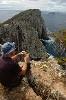
So it was that just a few days later I parked at the entry point, alongside 4 other vehicles of multi-day walkers. The weather was overcast but there were two or three minor gaps of blue starting to appear so I surmised that the weather would improve during the day and started out after signing the book indicating where you are planning to go.
The track was narrower than I’d envisaged and, after crossing the Red Tape Creek where there was a neat one-man-only swinging bridge, the trail headed uphill and, after half an hour my body was sweating though my hands were nearly numb. The nearly continual winds from the south and west don’t carry any warmth with them around here.
I looked across to Mount Anne, highest peak in the southwest. Its bare jagged ramparts were shrouded in mist that constantly cloaked the summit with fingers of gossamer drooping from the cloud belt.
I moved on to the boardwalks. Thank goodness for them I was thinking, this was a really boggy area. I pushed on for another 20 minutes and then the boardwalks ended. I came across a small bog, then another. In fact, they became quite repetitious, quite difficult for walking as I alternatively straddled, jumped sideways, took alternative routes and even looked to make new ones on occasions.
Then the bogs stopped. Indeed, it became one continuous bog. The track was in appalling state and the weather started closing in as if to bring the wrath of God upon me. What had I done to deserve this?
Intermittent drizzle drifted across the marsh land. Where there were rivulets thick, almost impenetrable scrub made trekking even more difficult. You had to keep your eyes peeled for the alternate routes, thin lines through the undergrowth where others had passed before, often only given away by a bent branch or two, other times trampled flat.
On more than one occasion my foot disappeared over my ankle in mud when I could see no other trail. By now I was saturated, reminiscent of my day at Cape Hauy only with mud thrown in. At least there the way was stable and the footing sure.
At some point heading well past the two hour mark I came to a point where the bog was horrific. I had to take a side alley, knocking down vegetation as I did until I finally found the track again. The precipitation was closing in. The cloud line had dropped 100 metres and looked ominous. I could feel the onset of hypothermia; my hands were getting worse, I could scarcely bend my fingers at all they were so cold. How glad was I that this was summer!
It was decision time and I knew I would be disappointed at not having made it but one’s health is always the first priority so I decided to turn back. I reconciled myself with the knowledge that any pictures I took would have been fairly useless due to the low cloud cover and, in addition, I could no longer use my camera because the lens were continually fogging up and my fingers couldn’t operate anything the way they were.
I hacked back around the horror section. It sounds good in theory but I couldn’t find the trail. No matter where I turned there seemed to be no sure track, just branches down here and there that led me up false leads. I continually turned back, getting no closer until I broke out into a clear section of vegetation covered bog and decided to work my way over to where a rivulet was, easily identified by the tree line.
For the first time in my bushwalking life, I was truly lost, I was truly concerned for my safety. At times I resorted to yelling out “coo-ee” but I knew that would be futile. There was so much noise with the wind in the scrub and the ever present rushing streams that my cries would be inaudible. It had been about 15 minutes since I last saw the track. I worked my way alongside the stream line until, bingo, I found the trail; or, had I?
I didn’t recognize this crossing but it was definitely the track. However, it was on the wrong side of where it should have been. I worked across and kept going, glad to have a made pathway in sight again. It wasn’t but a few minutes later when I came to a river. To ford this I would need a bridge; there wasn’t one and I didn’t fancy getting wet, potentially to my thighs, crossing this one on my own.
I made another decision, turn back and follow this trail until it reached the one I had been on.....hopefully!
The drizzle made things unpleasant in the open but I pushed on and came to a bog that I found my way around. There was something familiar about it and I continued until I reached a rivulet that I had crossed before. The coo-ee might have been inaudible, but my sigh of relief would have carried some way.
Apparently, I had done a 180 degree turn when trying to bypass the big bog and come out a couple of hundred metres past it when I picked up the trail again. I couldn’t check the map because it was raining and I didn’t have my glasses but I guessed, correctly, that it was the second crossing of Anne River that I’d reached. How frustrating when I later realised I had been within about 20 minutes of my goal.
Still, I was deliriously happy to be following what I knew again, as I saw a footprint and matched it up to my boot and then came across a spot where I’d taken a picture. My pace quickened to avoid full hypothermia and get some shelter yet it wasn’t long before the weather broke and, here and there, I spied patches of blue over Lake Pedder. However, when I looked back from whence I’d come, the drizzle continued.
It was hard to believe that the last part of the trail was dry. The vagaries of the weather in these parts never ceases to surprise. It is a truly wild area and I can understand what drags people here to experience one Australia’s true wonders. I just hope their experience is better than mine.
I undressed and hung my clothes out to dry then put fresh ones on to try and get warm.
It moved slowly, obviously sated and I pondered where it had come from, how far it had travelled. Where was it heading to next? I figured anywhere outside would be good, since on my ratings list for travelling companions, leeches rate very lowly.
 Viewed 5543 times")
- Where it became really difficult