NE Ridge of Anne

Bushwalking pictures.
Forum rules
Please keep the width of embedded images (using [img] [/img] tags) in this forum to no more than 800 pixels wide (this will avoid them being clipped without notice by most users' window sizes). Attached images can be any resolution so long as the file size is no more than 1 MB (attachments will be displayed by the forums as thumbnails no larger than 800 pixels linked to the full-size image).

Please include a description of the pictures' content so that readers know what they're all about.

For topics focussed on narrative rather than the photos, please consider posting in one of the 'Trip Report' forums instead.

NE Ridge of Anne

Postby Pedro » Thu 04 Sep, 2008 8:29 pm

Just spent a night on the NE Ridge. I'd almost forgotten how bad that track is - some of the more dreadful memories fade a bit over a few years, but I've well and truly had them reinforced. The plains were more like a lake and there are heaps of trees down over the track when you are in the forest. Its still fairly well marked, but it would be nice if any parties heading that way took a bit of tape with them - playing find the next marker still consumes a lot of time and getting geographically embarrassed on that hill is no joke.

Once I got to the top, there turned out to be a little more snow than I expected - up to a metre in places, very soft and me with no snow shoes - bugger. Took and hour to get to a place where I could camp and then probably only a quarter of the way along towards the Pandani shelf. That would have been a delight if I could have got there but I wasn't up to the snow slog. Here are a few pics:
NE Ridge_1.JPG

NE Ridge_2.JPG

NE Ridge_3.JPG


Didn't see anything of Anne until I was back down on the Plains.
User avatar
Pedro
Atherosperma moschatum
 
Posts: 84
Joined: Thu 01 May, 2008 9:02 pm
Region: Tasmania

Re: NE Ridge of Anne

Postby tasmaniac » Thu 11 Sep, 2008 1:07 pm

Hey Pedro, That sounds (and looks) like a bit of an adventure, well done! Just wondering which way you went up. Was it the normal route via Mt. Eliza or was it via the N.E. ridge? If it was the latter could you please post a bit of info about that route, e.g. where it starts from, walking time in good conditions, condition of the track/route, is it harder than the other track, any tricky bits to watch out for, etc, etc??? I am very interested in doing this walk sometime, so any info would be gratefully received.
tasmaniac
Athrotaxis cupressoides
 
Posts: 117
Joined: Thu 11 Sep, 2008 12:42 pm
Region: Tasmania

Re: NE Ridge of Anne

Postby Mickeymoo » Thu 11 Sep, 2008 10:02 pm

Nice series Pedro, such a beautiful area, I could imagine it would have been pretty hard going with all the snow that must have been up there, pity about not getting much of a view of Anne, its such a great angle from that side for photos, it would have looked pretty amazing with all the snow I would imagine..

Michael.
Mickeymoo
Athrotaxis cupressoides
 
Posts: 410
Joined: Fri 11 Jan, 2008 12:28 pm
Location: Sandford
Region: Tasmania
Gender: Male

Re: NE Ridge of Anne

Postby Pedro » Thu 11 Sep, 2008 10:43 pm

Hi Tasmaniac

PWS and others don't necessarily encourage visitors to this area - it is a fairly fragile alpine area - camping and walking are tough on it..

I used what I have always thought of as the standard track which leads around to Lake Timk. There is no comparison between this track and the Eliza track - the NE Ridge Track is rough, poorly marked and hard. Its a marked track (starting with a PWS log book), that utilises the remains of an old 4 wheel drive track to cross the plains and then, after about two hours walking, breaks off from the Timk track and heads up the ridge. There is no marker on the road and the track hasn't been maintained for years, although some kind souls seem to be renewing the track markers every now and again. The track across the plains is reasonably obvious most of the time - just a double pad with few markers. It is wet on the button grass, with some nasty patches of tea tree swamp. There is one creek that has to be waded - usually not deep, but it was running very hard last week and I ended up with boots full of water - no fun when I was in deep snow four hours later. About 15 minutes past the creek ( 2 hours from the road) there is a fairly obvious, but unmarked (except for a bit of tape) turn off into the forest. If you miss this, you will eventually end up at lake Timk, but it might take a day or two. Once in the forest and heading up the ridge, route finding becomes tedious and difficult. I did this trip once when there was no track (late 60's) and that really was hard, but even now the track can be very hard to find and the chances of making progress without it are low. I've found that you can be on the track, but not know where to go next and have a lot of trouble finding the next marker. About an hour from the turn off, the track passes through a delightful fern glade on the banks of a stream, but is particularly hard to follow through this area.

The last section onto the Ridge is a steep climb. It usually takes me about 6 hours from the road to the top of the Ridge and which time you still need a bit of time (up to an hour) to walk along the ridge towards Anne to find a suitable campsite. The track comes out on the Ridge very close to Anne - A - Kananda - a very spectacular sink hole. There is a track from there through the scoparia the eventually leads to the Pandani Shelf. There is also a route along the top of the cliffs above the Shelf which leads along to Anne.

In warm, dry weather the last 3 hours of the track can be quite dry, so be prepared to carry water for that section.

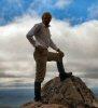
Last week I had great difficulty moving around on the Ridge because of deep snow - I ended up camped in the first suitable piece of bush that I could find, probably not much more than 100 metres from where I got out of the forest:
NE Ridge_4.JPG


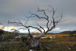
Overall, you need to be pretty confident in route finding and happy to work pretty hard for about 7 hours to use this track. I was dirty , wet and cold and by the time I got into the tent, but there were some rewards along the way:

NE Ridge icicles.JPG


I've left out the location of the track start - I don't see the need to publish that here. Send me a private message when you need it.

Pedro
User avatar
Pedro
Atherosperma moschatum
 
Posts: 84
Joined: Thu 01 May, 2008 9:02 pm
Region: Tasmania

Re: NE Ridge of Anne

Postby tasmaniac » Fri 12 Sep, 2008 8:55 am

Thanks Pedro, Wow! That certainly doesn't sound like an easier alternative to the normal way up. I don't think I'll be trying that one any time soon. Thanks again for your info.
tasmaniac
Athrotaxis cupressoides
 
Posts: 117
Joined: Thu 11 Sep, 2008 12:42 pm
Region: Tasmania

Re: NE Ridge of Anne

Postby Pedro » Fri 12 Sep, 2008 2:10 pm

Hey Mickeymoo

I think that you had the right idea going to Lake Judd. I thought of doing that, then started to get ambitious - always a mistake.

There were hints of a view:
Mt Lot.JPG
Mt Lot from the NE Ridge


and when I finally saw Anne from below, it was well covered:
Mt Anne.JPG


Still every experience in the Tasmania bush is a good one, even the rough trips.

Pedro
User avatar
Pedro
Atherosperma moschatum
 
Posts: 84
Joined: Thu 01 May, 2008 9:02 pm
Region: Tasmania

Re: NE Ridge of Anne

Postby Mickeymoo » Fri 12 Sep, 2008 5:22 pm

Yeah it certainly looked like there was a fair bit of snow on the higher areas, although I was originally heading to sara jane which looked a little better. Have to agree any walk rough or not in Tassie is great :) it was quite funny though I passed a couple of guys heading to Lake Judd on my way out, carrying nothing but cameras and maybe a jumper, what was even worse was that in the log book they had planned to go to Mt Lot and LOts Wife in a return daytrip :? as it was they must have got back in the dark as a couple of mates I was meeting said they showed up at Lake Judd late in the day like 3pm or something like that! I would definantly say ambition got the better of those two :D

Michael.
Mickeymoo
Athrotaxis cupressoides
 
Posts: 410
Joined: Fri 11 Jan, 2008 12:28 pm
Location: Sandford
Region: Tasmania
Gender: Male

Re: NE Ridge of Anne

Postby tasadam » Fri 05 Dec, 2008 11:51 am

I was just having a bit of a play with some images I took when I was in that area in Feb 2008.
Here's one I thought I'd share.
It's a HDR of 5 images - I made it from the original JPG's out of the camera so I haven't corrected the CA from the raw images in PS.
Other than that, I didn't think it was too bad.

D2C_5369_70_66_67_68ps (Medium).jpg
Pandani Shelf, northeast of Mt Anne
User avatar
tasadam
Magnus administratio
 
Posts: 5900
Joined: Tue 10 Apr, 2007 6:58 pm
Location: Near Devonport, Tasmania
ASSOCIATED ORGANISATIONS: TasmaniART, Smitten Merino, Macpac
Region: Tasmania
Gender: Male


Return to Gallery

Who is online

Users browsing this forum: Bing [Bot] and 15 guests