A Few Winter Walks

Bushwalking pictures.
Forum rules
Please keep the width of embedded images (using [img] [/img] tags) in this forum to no more than 800 pixels wide (this will avoid them being clipped without notice by most users' window sizes). Attached images can be any resolution so long as the file size is no more than 1 MB (attachments will be displayed by the forums as thumbnails no larger than 800 pixels linked to the full-size image).

Please include a description of the pictures' content so that readers know what they're all about.

For topics focussed on narrative rather than the photos, please consider posting in one of the 'Trip Report' forums instead.

A Few Winter Walks

Postby WarrenH » Mon 07 Jun, 2010 9:09 pm

Oh Arrh, it be winn-terr here in the mountains of the SE!

It's the worst winter that I've ever known ... because I like to wear jumpers in winter, not just T-shirts. I prefer two-dog winters, not hot sweaty ones. It could be climate chance?

I went for a walk up a Travelling Stock Route and across a paddock, today. I saw some Curly Mitchell Grass. Today was the first time that I have seen Curly Mitchell Grass, which was not being shown on TV. I was most impressed. I walked back into town and went to the library. I was sure that in the library I could confirm that what I saw was the famous Curly Mitchell Grass but the library was closed ... and had been closed for decades.

Image

Gundaroo Common.

Image

Gundaroo township.

Image

Image

Warren.
Last edited by WarrenH on Tue 08 Jun, 2010 11:27 am, edited 6 times in total.
WarrenH
Phyllocladus aspleniifolius
 
Posts: 990
Joined: Thu 07 Jan, 2010 6:54 pm
Region: Australian Capital Territory

Re: A Few Winter Walks

Postby kanangra » Tue 08 Jun, 2010 8:51 am

I like that first shot.

K.
kanangra
Athrotaxis selaginoides
 
Posts: 1340
Joined: Sun 25 May, 2008 3:52 pm

Re: A Few Winter Walks

Postby WarrenH » Tue 08 Jun, 2010 9:34 am

Thank you Kanangra. It is a very humble sign in Lute Street, Gundaroo. The paddock at the end of this sign is best described as;

Gundaroo Common

A 60 hectare site of national heritage significance.
This remnant contains White Box, Yellow Box, Blakely's Red Gum, open woodland.
Natural Temperate Grassland and populations of the threatened Golden Sun Moth and Supurb Parrot.
Part of the Southern Tablelands Grassy Ecosystems Conservation Management Network
Managed by the Gundaroo Commons Trust since 1870
For more information please contact the Gundaroo Common Trust on 62368129

Sponsors of the Gundaroo Common are;
The World Wildlife Fund
Conservation Management Network
Infrastructure, Planning and Natural Resources
Department of Lands
Gundaroo Common Trust
Natural Heritage Trust
Threatened Species Network
National Parks and Wildlife Service of New South Wales.

This is a most valuable 60 hectares of grassy woodland, indeed.

Warren.
WarrenH
Phyllocladus aspleniifolius
 
Posts: 990
Joined: Thu 07 Jan, 2010 6:54 pm
Region: Australian Capital Territory

Re: A Few Winter Walks

Postby WarrenH » Wed 30 Jun, 2010 3:47 am

'Lost For Choice' ... ahead to the Clear Range, return to the Booth Range, left is to home or right to the Mount Clear camp site. Warm places, cold places, ... spoilt for choice. Maybe I should stand still? Maybe I should sit down?

Image


Warren.
WarrenH
Phyllocladus aspleniifolius
 
Posts: 990
Joined: Thu 07 Jan, 2010 6:54 pm
Region: Australian Capital Territory

Re: A Few Winter Walks

Postby WarrenH » Thu 08 Jul, 2010 7:15 am

A Winter dawn at the edge of the grasslands. The Bicentennial National Trail, Southern Highlands, New South Wales.


Image


Warren.
WarrenH
Phyllocladus aspleniifolius
 
Posts: 990
Joined: Thu 07 Jan, 2010 6:54 pm
Region: Australian Capital Territory

Re: A Few Winter Walks

Postby kanangra » Thu 08 Jul, 2010 9:13 am

Atmospheric!
kanangra
Athrotaxis selaginoides
 
Posts: 1340
Joined: Sun 25 May, 2008 3:52 pm

Re: A Few Winter Walks

Postby WarrenH » Mon 19 Jul, 2010 3:33 am

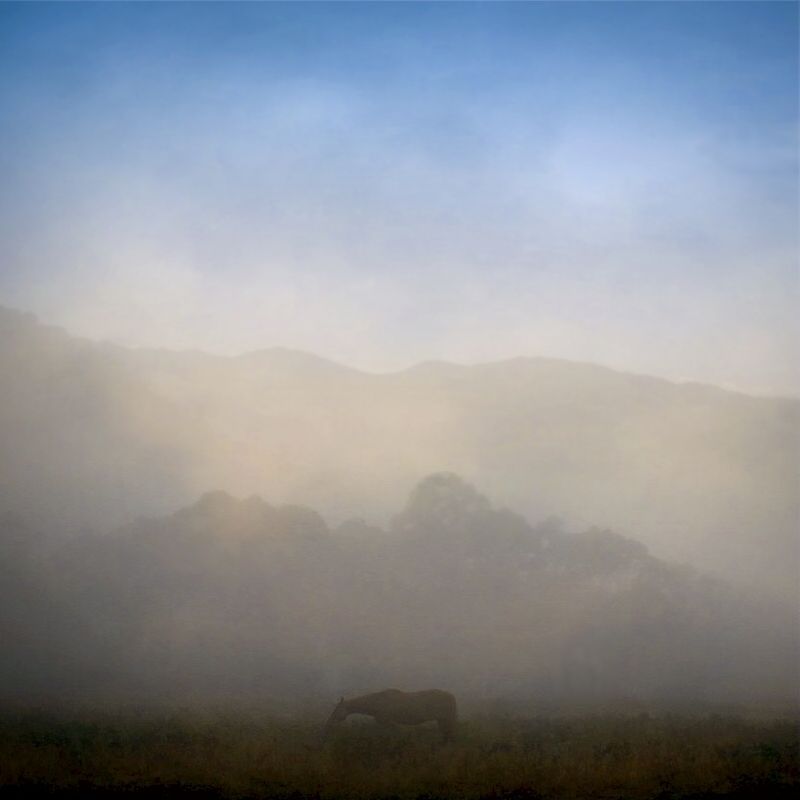
Kanangra, I find it not easy to be outside taking photographs before sunrise in Winter. The atmospheric rewards are very good but my fingers sting, so that is my only atmospheric image this winter.

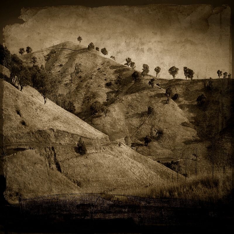
I went for a windy walk and hiked my bike heaps yesterday, on the Bicentennial National Trail. From Lerida Outstation up and along the Cullerin Range, across cattle grids, through unfenced farm paddocks and the open woodlands to Yorkdale Travelling Stock Reserve near Yankee Jack's Hill on a flat part of the Great Dividing Range, and finished at the lookout high above Murray's Swamp on the Lake George Range. It was very cold and windy.

I got within 10 metres of two Wedge Tail Eagles at Yankee Jack's Hill. I had forgotten how big Eagles are (or did I really not know). Their wingspan(s) left me in awe. At one time, there were six Eagles flying in a tight circling formation about 50 metres above the ground, looking straight up. Until yesterday I had only seen soaring eagles hundreds of metres away, mere specks ... apart from one Eagle that I once saw in a cage. Seeing the Eagles doing their stuff up close yesterday, was a thrill.

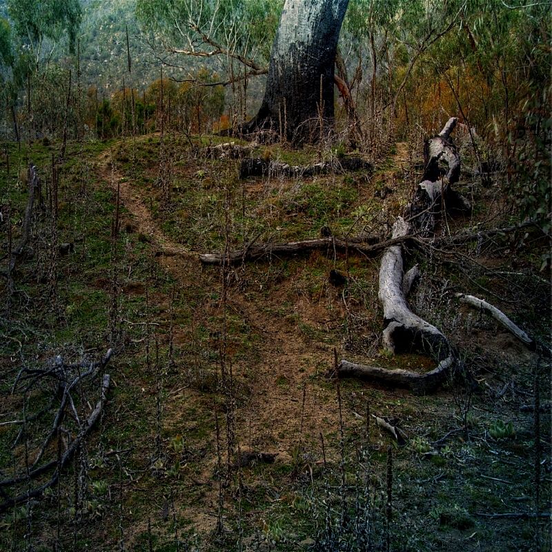
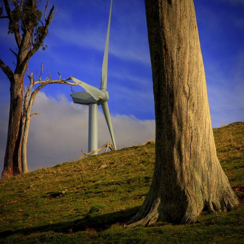
Skeletal objects on the Cullarin Range.

Image


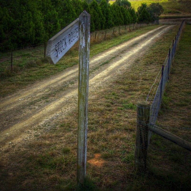
The unformed road and gate of Yorkdale TSR (called Lerida TSR in the new BNT guide book).

Image


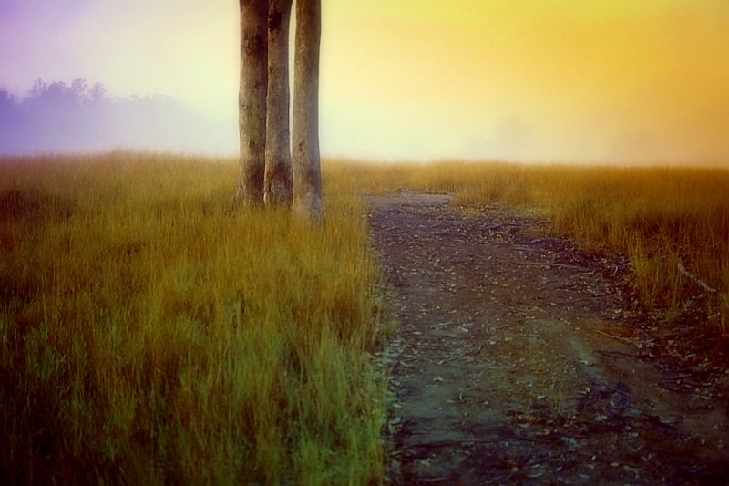
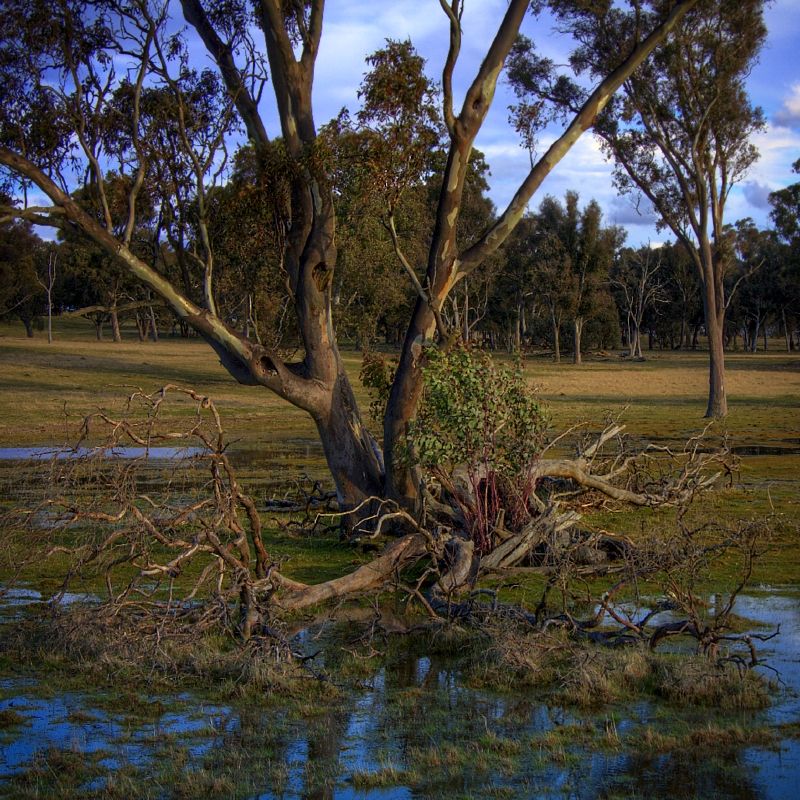
A Red Gum or a White Sallee? ... or a Black Sallee? ... almost standing in water, on the Great Dividing Range. I'm up on trees, but this tree has got me stumped. This is most unusual, I will return and identify it (in Spring). I walked up to the tree because I was surprised to see what I thought was a Black Sallee growing here on flooded ground (seen from a distance). After 16 years of drought and now there is standing water, if only several centimetres deep. It has been a good year for rain, at last. There is good water in the farm dams and some creeks are continuing to flow.

Image


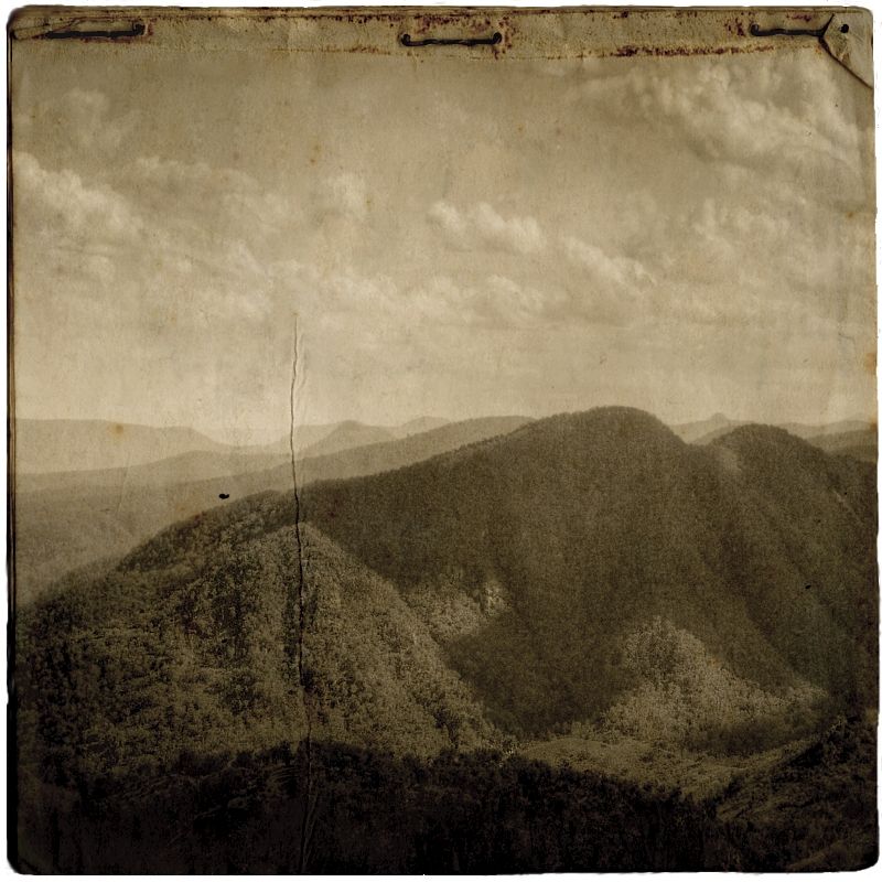
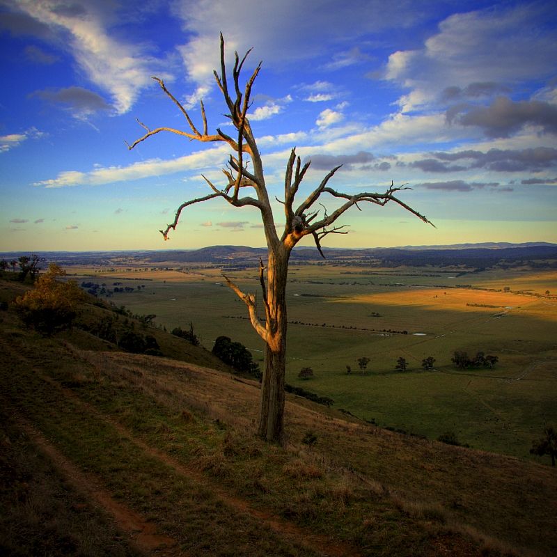
The track above Murray's Swamp.

Image


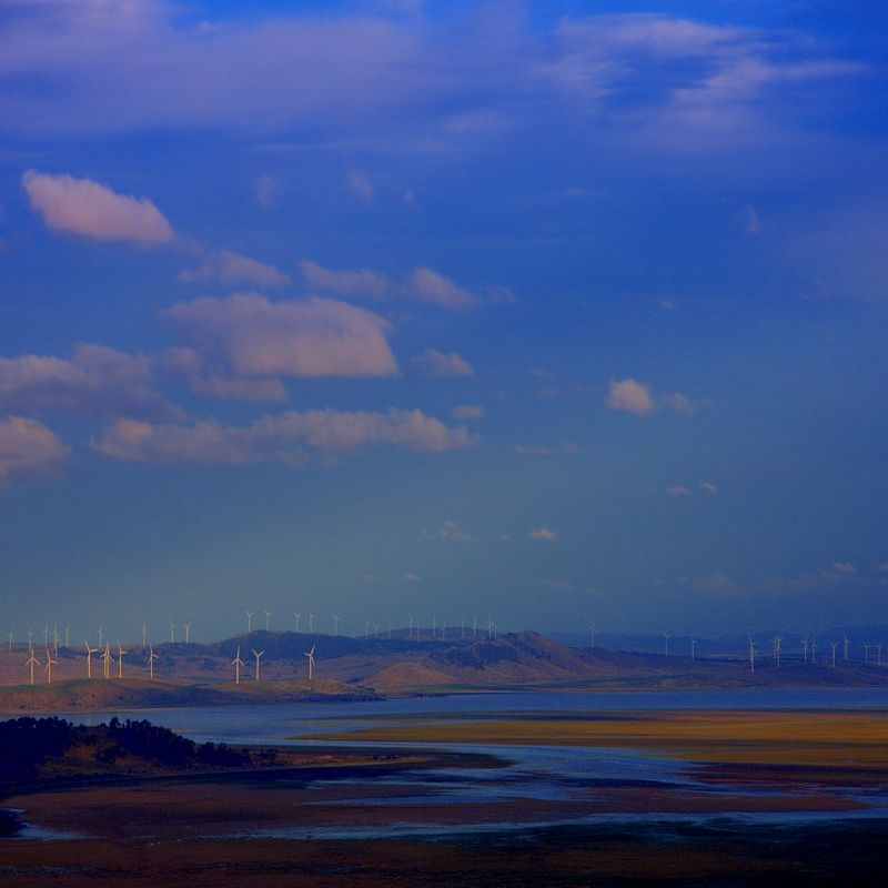
Lake George has water in it. Apart from only seeing the odd tennis court size puddles in Lake George, during the past decade or two, Lake George is now attempting to impersonate a real lake ... well, go Lake George. In the foreground is a somewhat soggy Collector Creek Travelling Stock Reserve. After yesterday, I now know which way Collector Creek flows. It flows into Lake George. I hope that you find that interesting? I always thought that building a million dollar bridge over the slight depression called Collector Creek was some kind of sick bridge contractor's joke, when a low level gravel crossing is all that was needed on the Federal Highway. I had no idea that some bridge builders could foresee the future.

Image


Warren.
WarrenH
Phyllocladus aspleniifolius
 
Posts: 990
Joined: Thu 07 Jan, 2010 6:54 pm
Region: Australian Capital Territory

Re: A Few Winter Walks

Postby kanangra » Tue 20 Jul, 2010 2:02 pm

Warren,

Fascinating stuff. I have a few books on the BNT and must look out the route you describe. When did all those wind turbines go in? Is it that long since I have been down to Lake George? I have never seen them before?

K.
kanangra
Athrotaxis selaginoides
 
Posts: 1340
Joined: Sun 25 May, 2008 3:52 pm

Re: A Few Winter Walks

Postby WarrenH » Thu 22 Jul, 2010 9:19 am

Kananga, about 3 years ago the wind turbines started appearing and it was late last year that I saw the first turbines in action. The photos do not show anywhere near the number of turbines that are here. They are at Tarago, Lake Bathhurst, Lake George and on the Cullerin Range, there is over 100 turbines that I've seen. The noise produced by the foils is huge. When I was at Yorkdale TSR about 8 kilometres from the closest turbine that I could see on the Cullarin Range, I was down wind from the turbines, I could still hear them.

Kanangra, this week the latest trail updates were posted on the BNT site. Although I have the newest editions, I still had a dozen updates to stick into the track notes. The new guide books are not the mudmaps of the previous editions. The maps in the new books are topos and are very well done.

The latest 2010 BNT updates are at ... http://www.nationaltrail.com.au/updates.html there are also the updates for 2008 and 2009, as well.

We were talking about the BNT from Mount Werong to Waiborough, not too long ago? In the latest updates, National Parks has locked the gates at Limeburners Fire Trail, and is monitoring the trail and now Limeburners Trail and the campsite on Murruin Creek are for walkers only.

Warren.
WarrenH
Phyllocladus aspleniifolius
 
Posts: 990
Joined: Thu 07 Jan, 2010 6:54 pm
Region: Australian Capital Territory

Re: A Few Winter Walks

Postby kanangra » Fri 23 Jul, 2010 5:58 pm

thanks for the tip. Glad to hear Limeburners is now off limits to cars. Murruin Ck is a very pretty creek. Particularly near its junction with the wollondilly. Gee it must have been a while since i was down Lake George way as i've not seen the turbunes.

K.
kanangra
Athrotaxis selaginoides
 
Posts: 1340
Joined: Sun 25 May, 2008 3:52 pm

Re: A Few Winter Walks

Postby WarrenH » Sun 01 Aug, 2010 6:02 pm

A few days ago I went and had a chat to an old Mate who is living in Albury and we took our treadlies on the Hume and Hovel Trail. We only did about 12 ks out and 12 back but we crossed the rail bridge ... it was a tad thrilling and as scary as all hell crossing the river, not knowing the railway time table.

'Three White Lights' ... from the Hume and Hovel Walking Track, n'nor' east of Albury Station. The Flour Mill in the twilight ... when I got home my wife Helen said, "That looks like a concentration camp." My dear wife Helen is most perceptive.

Image


I might ride my bike out to Manildra when I get back from riding the BNT from Killarney to Canberra. The flour mill out at Manildra, not far from NW of Orange, is the biggest flour mill in the Southern Hemisphere. Seeing that would be worth a bike ride and a walk through the mill.

Warren.
Last edited by WarrenH on Mon 02 Aug, 2010 10:28 am, edited 1 time in total.
WarrenH
Phyllocladus aspleniifolius
 
Posts: 990
Joined: Thu 07 Jan, 2010 6:54 pm
Region: Australian Capital Territory

Re: A Few Winter Walks

Postby eddie the eagle » Sun 01 Aug, 2010 7:15 pm

Hi Warren,

Looks great - I grew up not far from Manildra, and remember the Travelling Stock Route signs near Blayney.

Cheers,

eddie
eddie the eagle
Athrotaxis cupressoides
 
Posts: 114
Joined: Tue 13 Apr, 2010 10:20 am
Region: New South Wales

Re: A Few Winter Walks

Postby WarrenH » Mon 02 Aug, 2010 8:15 pm

Eddie, Cheers Mate.

The rusty cattle trough ... the hills of Tunnel Road approaching Albury, on Map #6, Hume and Hovell Walking Track.

Image


Warren.
WarrenH
Phyllocladus aspleniifolius
 
Posts: 990
Joined: Thu 07 Jan, 2010 6:54 pm
Region: Australian Capital Territory

Re: A Few Winter Walks

Postby iandsmith » Thu 12 Aug, 2010 9:19 am

Like some of the imagination used in the pics there; given me some ideas.
Never been to Gundaroo either, have put it on my itinerary for end of September.
Here's a couple of shots from a sojourn down that way en route to Wee Jasper.
Attachments
Wee Jasper 033sp.jpg
Here's lookin' at you
Wee Jasper - Taemas Bridge (1)sp.jpg
Shot from Taemas Bridge
Wee Jasper 028sp.jpg
Land degradation
Wee Jasper - Taemas Bridge sand patterns sp.jpg
Sand patterns in the river
User avatar
iandsmith
Athrotaxis cupressoides
 
Posts: 364
Joined: Thu 22 Jan, 2009 3:27 pm
Location: Newcastle

Re: A Few Winter Walks

Postby WarrenH » Thu 12 Aug, 2010 6:45 pm

Ian, if I've inspired you, that is what I hope we gain from each other? ... and thank you Mate, your comment makes my postings worth the effort.

Anyway, I was on Google Maps and and looking at the images of the Capertee Valley and tracing the BNT while I keep waiting for the LHPA permits so I can legally use and camp on the TSRs that are on Crown Land (permits which I applied for several weeks ago, for 14 LHPA Regions that run along the Great Divide) and I saw this awesome shot. Your shot of the Capertee Valley, is tres cool. I'm looking forward to seeing the view, 101. I've only been in the eastern Capertee Valley.

A re-work of the Tunnel Road shot, 'Parchment Overshadows'.

Image


'Tearing-off Landscapes''. A shot of Milinigan Ridge and the Wollondilly River Valley, from New Yards Hill, at the transition of the Kanangra-Boyd and the Nattai Wilderness. I could have worked the edges of this image to look more realistic but that will be in another progression.

Image


Warren.
WarrenH
Phyllocladus aspleniifolius
 
Posts: 990
Joined: Thu 07 Jan, 2010 6:54 pm
Region: Australian Capital Territory

Re: A Few Winter Walks

Postby kanangra » Sun 15 Aug, 2010 8:51 am

Warren,

Now that is a place I haven't heard for a while. New Yards Hill. I was out that way a few years back. I had camped on New Yards Ck above the falls and took the Milnigang FT out to Cockpit ck. The track crosses the creek just below New Yards Hill. the track ends in a saddle just past there and then it is a long arduous descent to the Wollondilly River. there are a couple of old inholdings marked on the maps that could be worth a look?

K.
kanangra
Athrotaxis selaginoides
 
Posts: 1340
Joined: Sun 25 May, 2008 3:52 pm

Re: A Few Winter Walks

Postby WarrenH » Mon 23 Aug, 2010 1:29 pm

Kanangra, I'm very pleased to have triggered old memories of Kanangara, Mate.

On another note, I still haven't been granted the permits for the Bicentennial National Trail. My request for the permits was from August through October, ... maybe the BNT Association who are the organisers think that I requested the permits for August in 2011? ... or whatever.

'Approaching the High Country', the Great Dividing Range. It feels like Spring today, although it is forecast that there will be snow at 1300m and out on the western slopes at Orange and Bathurst. If there was snow on the ridges here, this would be a better image.

Image


One gets silly in Spring, don't you find? In Spring, I think that all nags up here in the High Country are mares in season. CJ, Banjo and Henry called them brumbies, that is an interesting word. I'm guessing that being retro is tres' cool at this time of the year?

Warren.
WarrenH
Phyllocladus aspleniifolius
 
Posts: 990
Joined: Thu 07 Jan, 2010 6:54 pm
Region: Australian Capital Territory

Re: A Few Winter Walks

Postby WarrenH » Thu 09 Sep, 2010 6:51 pm

The final image from this winter's walks (and cycle).

'Hung-up Needles' ....River Oak, Flee Creek, Brindabella Ranges, in the traditional Bimberi Wilderness. A hand coloured B/W image.

Image


Here in the ACT, this winter was the coldest winter since 1998 and the wettest winter (for rainy days not for the total rainfall) in 38 years. Last year was one of the coldest winters that I have ever known ... this year has been the best.

Warren.
WarrenH
Phyllocladus aspleniifolius
 
Posts: 990
Joined: Thu 07 Jan, 2010 6:54 pm
Region: Australian Capital Territory

Re: A Few Winter Walks

Postby stepbystep » Thu 09 Sep, 2010 7:05 pm

More great images(and words), much appreciated Warren, goodness knows what you'd do if you came down to Tasmania.
Cheers, sbs
The idea of wilderness needs no defense, it only needs defenders ~ Edward Abbey
User avatar
stepbystep
Lagarostrobos franklinii
 
Posts: 7625
Joined: Tue 19 May, 2009 10:19 am
Location: Street urchin
Region: Tasmania
Gender: Male

Re: A Few Winter Walks

Postby WarrenH » Sun 12 Sep, 2010 5:27 am

Stepbystep, thank you Mate.

Me'ol Mate Bill Burford from Tassy, told me that if I only went into the bush one more time, that I should make my last trip to Freycinet Peninsular. My dear wife Helen, has said to me several times, that we should go to Tassy. Helen and Bill were great Mates, when Bill was alive.

I don't want to go to Tassy yet. I would not trust myself going to Tassy because I might not want to come home. Bill told me many storeys about the great regions of Tassy that he explored. I still haven't seen the Great Dividing Range yet, just within a day's drive from home and I've been exploring the Great Divide for nearly 40 years ... I've spent a lot of time exploring the Great Divide.

When I finish the Great Divide ... I'll visit Tassy.

As soon as the TSR permits for the Bicentennial National Trail turn up (they are now only 5 week late, from the starting date that I requested and applied for), I'll be 3 months closer to coming to Tassy when I finish the trail. If I get permission to do the BNT legally, going by the book. This has been a fascinating exercise, applying to do the BNT, going by all the rules.

Finding that being legally unable to do the BNT, if one actually doesn't follow all of the rules and regs, not known to the BNT Association ... has been a very interesting unexpected exercise. I have made the BNT Association aware of several holes in their system, that they should have known about. The BNT Association claimed that they didn't know that in the LHPA Northern Rivers Region, through travellers camping on the TSRs were being charged $25 a day. That I find that very hard to believe.

Warren.
WarrenH
Phyllocladus aspleniifolius
 
Posts: 990
Joined: Thu 07 Jan, 2010 6:54 pm
Region: Australian Capital Territory


Return to Gallery

Who is online

Users browsing this forum: No registered users and 23 guests