Page 1 of 1

For map lovers and a change of perception of our world

PostPosted: Mon 20 Mar, 2017 11:12 am
by GPSGuided
Boston schools are starting to correct students' view of the world by standardising world maps charted using Peter projection. Out goes Mercator and its illusion field of 5 centuries.

https://www.theguardian.com/education/2 ... projection

Re: For map lovers and a change of perception of our world

PostPosted: Mon 20 Mar, 2017 12:10 pm
by taswegian
An interesting way to look at things.
It will always be an area that can't satisfy all aspects.
Projecting from a ball to a flat surface or visa versa, and something has to give. Somewhere.

Re: For map lovers and a change of perception of our world

PostPosted: Mon 20 Mar, 2017 12:41 pm
by Mark F
There are many equal area projections, Lambert being the best known. The Peters projection seems to be called the Gall-Peters on Wikipedia https://en.wikipedia.org/wiki/Cylindrical_equal-area_projection where it is claimed that it was devised by James Gall in 1855 while Arno Peters is claiming it as his invention in 1967?! Copyright lapsed?

I am waiting for the new Trump projection which shows the USA as 95% of the map with the rest of the non-islamic world squeezed in around the edges. That should be welcomed by the US education system.

Re: For map lovers and a change of perception of our world

PostPosted: Mon 20 Mar, 2017 3:36 pm
by GPSGuided
Effectively it's a reverse of Mercator. One stretched towards the poles, the other squeezed towards the equator. Right?

Re: For map lovers and a change of perception of our world

PostPosted: Wed 22 Mar, 2017 2:06 pm
by keithy
I always liked the Gall-Peters projection and wondered if it would ever replace the Mercator in established printed maps.

I have to get a print of the Gall-Peters projection to put up in the study now.

Re: For map lovers and a change of perception of our world

PostPosted: Wed 22 Mar, 2017 3:01 pm
by tastrax

Re: For map lovers and a change of perception of our world

PostPosted: Thu 23 Mar, 2017 6:36 pm
by GPSGuided
I couldn't mentally work out how they can maintain the proportions in a full rectangular map when they use latitude 45 N and S as the reference.

Re: For map lovers and a change of perception of our world

PostPosted: Fri 24 Mar, 2017 8:27 am
by ribuck
GPSGuided wrote:I couldn't mentally work out how they can maintain the proportions in a full rectangular map when they use latitude 45 N and S as the reference.

The general idea is that as the west-east dimension is stretched (towards the poles), the north-south dimension is shrunk by a similar amount. So the projection preserves land area, but not shape.

The Peter projection is no more "correct" than the Mercator projection. When you project a sphere onto a flat surface, you cannot accurately model shape, area, distances and bearings. You have to choose what is important. If the Boston schools want to teach geography accurately, they need to use globes instead of flat projections.

For the purposes of bushwalking, the choice of projection doesn't matter that much. The difference between grid north and true north is likely to be small compared to the difference between grid north and magnetic north.

Here's the Peirce Quincuncial projection. I think it's the most beautiful presentation of the continents. You just have to not mind that Antarctica is split into four!

peirce-quincuncial.jpg
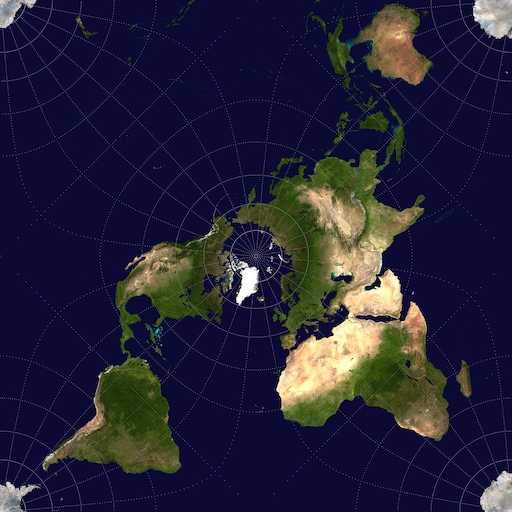
peirce-quincuncial.jpg (151.1 KiB) Viewed 10760 times


And here are some thoughts from XKCD:

Image

For map lovers and a change of perception of our world

PostPosted: Fri 24 Mar, 2017 9:51 am
by GPSGuided
That makes sense to if it only preserved the area while inducing distortion in the east-west axis. I don't know what to think of XKCD. Wow!


Sent from my iPad using Tapatalk