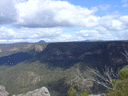
Another thing I liked about SIX is that the SIX image and contoured map were the same scale (there is also a slider so that you can overlay one on the other) whereas for Google you had to open Google Maps which was a different scale and isn’t contoured. I had, however, forgotten about the Google historical feature for finding overgrowing tracks. The 2009 image is certainly the best of the series.
The SIX property boundaries show, and also noted by Sloss, that the Chasm Track and Dome Track are on private property, albeit unfenced. It is strange that both Google Maps and SIX maps show these ‘private’ roads, but don’t show the National Park Chasm Trail, nor even the Nattai Valley Rd west of the Wattyl Ridge property.
The SIX image also best shows an interesting connecting trail from the Dome Track east to a trail from Wattyl ridge on the next ridge, as well as another trail from here returning across the creek and up to yet another point of the back fence of Wattyl Ridge.
PS: I've just now found I have a 1992 Ed. of Sloss’s “Mittagong Nattai Walking Tracks for the Southern Highlands” that I don’t ever remember reading. The only thing it shows is the Chasm Trail labelled as Rocky Water Holes Track.
A Day in the Nattai Valley.
Forum rules
Posting large/multiple images in this forum is OK. Please start topic titles with the name of the location or track.
For topics focussed on photos rather than the trip, please consider posting in the 'Gallery' forum instead.
This forum is for posting information about trips you have done, not for requesting information about a track or area.
137 posts
• Page 4 of 5 • 1, 2, 3, 4, 5
Re: A Day in the Nattai Valley.
![]() by Grabeach » Tue 30 May, 2017 11:15 pm
by Grabeach » Tue 30 May, 2017 11:15 pm
- Grabeach
- Athrotaxis cupressoides

- Posts: 309
- Joined: Wed 12 Oct, 2011 2:09 pm
- Region: New South Wales
- Gender: Male
Re: A Day in the Nattai Valley.
![]() by tom_brennan » Wed 31 May, 2017 8:32 am
by tom_brennan » Wed 31 May, 2017 8:32 am
Grabeach wrote:It is strange that both Google Maps and SIX maps show these ‘private’ roads, but don’t show the National Park Chasm Trail, nor even the Nattai Valley Rd west of the Wattyl Ridge property.
When Alex and I spoke to Spatial Services (formerly LPI) at Bathurst, it sounded like there had been a bit of unexplained tension with NPWS and NPWS hadn't been giving LPI track data for inclusion on the maps. That's apparently been resolved - but there's a long backlog of tracks to review/add. But it explains why so many NP tracks are missing, even when similar ones on private or other public land are there. There are plenty of other examples in other parts of the NP estate, for example, the Wollangambe tracks end exactly at the park boundary!!
Grabeach wrote:Another thing I liked about SIX is that the SIX image and contoured map were the same scale (there is also a slider so that you can overlay one on the other) whereas for Google you had to open Google Maps which was a different scale and isn’t contoured.
Yes, it's definitely useful having the contour layer. If you're looking for a simpler alternative to SIXMaps, my mapping tool also has the contour layer and slider - http://maps.ozultimate.com/
Bushwalking NSW - http://bushwalkingnsw.com
-

tom_brennan - Athrotaxis selaginoides

- Posts: 1415
- Joined: Wed 29 Sep, 2010 9:21 am
- Location: Sydney
- Region: New South Wales
- Gender: Male
Re: A Day in the Nattai Valley.
![]() by michael_p » Wed 31 May, 2017 11:11 am
by michael_p » Wed 31 May, 2017 11:11 am
tom_brennan wrote:See below for the map from Sloss' 3rd edition. The names seem pretty confusing to me. You have "The Chasm Trail" leading to "Chasm Lookout" and "The Chasm Lookdown". But then you have the "Chasm Track" joining up with "The Dome Track", leading into Rocky Waterholes Creek. And finally, the lookout that I would consider the Chasm Lookout, doesn't even get a name!
Wow...Yep, the names have been changed. I found my copy of the guidebook in the bottom of my map draw and it has no edition number but is copyright 1998. Good chance mine is a Edition 1. No wonder there has been confusion.
Hughmac wrote:Hi Michael. It is possible to get across Camelot Ck to the lookout track, but it is a scrub bash with a little scrambling. Camelot Ck itself is beautiful. I recall Aaron christened it 'Spoon Drain Ck' due to the shape of parts of it's bed.
Hi Hugh,
It wasn't hard to get up to the lookout track (the old Rocky Waterholes Creek Lookout Track) from Camelot Ck. It was at least 10 years ago so my memory is a bit rusty and I think it was my first trip into this area. We walked down to Camelot CK then followed the FT down for a bit, then turned around and walked back up before consulting the map and picking a side gully to go up, headed west and after a short bush bash we hit the old RWC track then onto the lookout.
Michael.
One foot in front of the other.
-
michael_p - Athrotaxis selaginoides
- Posts: 1388
- Joined: Sun 15 Nov, 2009 6:58 pm
- Location: Macarthur Region of Sydney.
- Region: New South Wales
- Gender: Male
Re: A Day in the Nattai Valley.
![]() by dwtrailruns » Thu 08 Jun, 2017 2:37 pm
by dwtrailruns » Thu 08 Jun, 2017 2:37 pm
Hey guys,
Thanks for the discussion about Nattai which has been going for a long time now - I really appreciated reading all of your cumulative experience before heading out over the weekend.
I'm a trail runner and orienteer (I'm on the board of Southern Highlands Orienteers) and I led a couple of trail running friends on a 3 hour adventure out there on Sunday.
I thought I was heading to Ahearns lookout from looking at some of NPWS pages, but in hindsight it looks like we headed out to Chasm lookout first via a major track/fire trail? We had clear views of Mount Jellore, it was great.
We then headed down Starlights via the Southern trail head (what looks like the start of the Ahearns track, but I didn't see a branch?) before heading north across the creek/gully and following the marked trail down the southern feet of cliffs before doing a quite steep section down to the Nattai. The route was very close to the Starlights marked on my topo map, but it doesn't sound entirely like what some of you have described as Starlights. Can someone confirm that we actually hit Starlights, or did we do something else? On the way out there was a STB with an arrown at the north trail head.
I have attached my Strava gps file if anyone wants to check it out. Some of the tracks (inlcuding Starlights at the bottom) were far less distinct than I expected. However, we had an awesome run/climb. So close to home and so wild!
Thanks for sharing all of your collective experience/wisdom!
Dean
- Attachments
-
- dwtrailruns
- Nothofagus cunninghamii

- Posts: 4
- Joined: Thu 08 Jun, 2017 2:19 pm
- Region: New South Wales
Re: A Day in the Nattai Valley.
![]() by tom_brennan » Fri 09 Jun, 2017 2:18 pm
by tom_brennan » Fri 09 Jun, 2017 2:18 pm
No, you went out Ahearns Track, and then down Slott Way to the Nattai.
Starlights turnoff is 130m further back north along the fire trail.
See http://maps.ozultimate.com/?id=1496981880067 - Starlights is the northernmost of the 3 tracks, Slott Way is the southernmost.
Starlights turnoff is 130m further back north along the fire trail.
See http://maps.ozultimate.com/?id=1496981880067 - Starlights is the northernmost of the 3 tracks, Slott Way is the southernmost.
Bushwalking NSW - http://bushwalkingnsw.com
-
tom_brennan - Athrotaxis selaginoides
- Posts: 1415
- Joined: Wed 29 Sep, 2010 9:21 am
- Location: Sydney
- Region: New South Wales
- Gender: Male
Re: A Day in the Nattai Valley.
![]() by dwtrailruns » Fri 09 Jun, 2017 7:47 pm
by dwtrailruns » Fri 09 Jun, 2017 7:47 pm
Hi Tom,
Thanks for letting me know. I thought we we heading too far south, but it was fairly hard to tell the gullies apart that high up. I also thought the two trail heads turned into one track (there is a track that heads north from the Ahearns track to join them only 100m or so from the start), so I didn't bother checking the north head out on the way back from Chasm lookout.
Thanks for the waypoints too, I'll use them to keep on the Ahearns track as well next time - I'll definitely be heading out for another run.
Appreciate your sharing!
Many thanks,
Dean
- dwtrailruns
- Nothofagus cunninghamii
- Posts: 4
- Joined: Thu 08 Jun, 2017 2:19 pm
- Region: New South Wales
Re: A Day in the Nattai Valley.
![]() by michael_p » Sat 10 Jun, 2017 11:36 am
by michael_p » Sat 10 Jun, 2017 11:36 am
dwtrailruns wrote:Thanks for the discussion about Nattai which has been going for a long time now - I really appreciated reading all of your cumulative experience before heading out over the weekend. Thanks for sharing all of your collective experience/wisdom!
Hi Dean and welcome. Happy to share my knowledge of this area and glad to read you had a good trail run.
As Tom said you ended up on the Slott Way. The Slott Way is getting a lot of use and has become well worn whereas the Ahearn Track has become overgrown at this point. When heading out to Ahearns it is very easy to head off on the Slott Way by accident. When you get to the tree with the red triangular marker go right to head out to Ahearns.
Below photo shows the red triangular marker in the tree at the start of the Slott Way. Keep your eye out for it and as I said above go right to head out to Ahearn Lookout.
Cheers,
Michael.
One foot in front of the other.
-
michael_p - Athrotaxis selaginoides
- Posts: 1388
- Joined: Sun 15 Nov, 2009 6:58 pm
- Location: Macarthur Region of Sydney.
- Region: New South Wales
- Gender: Male
Re: A Day in the Nattai Valley.
![]() by Grabeach » Sat 10 Jun, 2017 1:11 pm
by Grabeach » Sat 10 Jun, 2017 1:11 pm
Easy to do. A year or two back wife and I were in the area and went without a map for a ‘make it up as you go along’ stroll. Eventually headed for Ahearns L/O. Against my better judgement, I was ‘persuaded’ by the ribbons to head left. I realised soon after that something was wrong, but by then decided to follow this track to see where it went. Ended up at quite a good lookout above what I later learned was the Slott Way.
On the way back we followed the Ahearns Track up to the first rocky high point. Returning, I was clearing the track as we went, but only to the point of throwing stuff off the track and removing obvious obstructing branches. The most overgrown part is unfortunately at the junction, though I was kicking myself for not realising that the underlying track formation clearly dictated the way we should have gone.
On the way back we followed the Ahearns Track up to the first rocky high point. Returning, I was clearing the track as we went, but only to the point of throwing stuff off the track and removing obvious obstructing branches. The most overgrown part is unfortunately at the junction, though I was kicking myself for not realising that the underlying track formation clearly dictated the way we should have gone.
- Grabeach
- Athrotaxis cupressoides
- Posts: 309
- Joined: Wed 12 Oct, 2011 2:09 pm
- Region: New South Wales
- Gender: Male
Re: A Day in the Nattai Valley.
![]() by dwtrailruns » Thu 03 May, 2018 7:48 am
by dwtrailruns » Thu 03 May, 2018 7:48 am
Hi everyone,
Since my initial explorations (with all of your help), I've been out into Nattai a few more times, and I'm really enjoying it (although it broke my big toe on Christmas eve, lol). I've even guided a couple of groups out to Ahearns, who have been blown away.
There was also some fairly fresh (thinking Friday or Saturday) heavy walking boot tracks out to Ahearns, so figured that maybe one of you guys had been out there? I was also happy to find Murray's Way from the Ahearns Track down to Starlight's - that's a really helpful shortcut!
Next stop for me is Russell's Needle now that I've done all the close bits on the major trails.
I'm writing a short article on the area, and I'm just wondering, does anyone know the history of the tracks in the area? I've read a couple of brief histories, but there's no reference to Starlight's Track or any of the other tracks. Does anyone know when they were cut in and why? Was it to allow the Mittagong-Katoomba walk? Does anyone know why it's called Starlight's Track?
Thanks in advance!
Dean
- dwtrailruns
- Nothofagus cunninghamii
- Posts: 4
- Joined: Thu 08 Jun, 2017 2:19 pm
- Region: New South Wales
Re: A Day in the Nattai Valley.
![]() by michael_p » Thu 03 May, 2018 2:07 pm
by michael_p » Thu 03 May, 2018 2:07 pm
Starlights was used for moving livestock in and out of the valley. It's been there a long time. No idea how it got the Starlights name.
Before Warragamba Dam was built the Nattai was used for farming, forestry, and coal mining. Many of the tracks we use today are just old access roads that have become overgrown. There are some tracks that are recent additions like the Ahearn Track, which was a rough track that got cleared by some locals who also decided to make their own track (the Horse Track).
There are some photos on the second page of this thread that show Emmetts and Macarthurs Flat from the old days: viewtopic.php?f=47&t=17241
Cheers,
Michael.
One foot in front of the other.
-
michael_p - Athrotaxis selaginoides
- Posts: 1388
- Joined: Sun 15 Nov, 2009 6:58 pm
- Location: Macarthur Region of Sydney.
- Region: New South Wales
- Gender: Male
Re: A Day in the Nattai Valley.
![]() by tom_brennan » Fri 04 May, 2018 8:35 am
by tom_brennan » Fri 04 May, 2018 8:35 am
Captain Starlight was the (anti-)hero bushranger from the classic Australian novel Robbery Under Arms. I assume it was named after him for some reason - but don't know what.
Bushwalking NSW - http://bushwalkingnsw.com
-
tom_brennan - Athrotaxis selaginoides
- Posts: 1415
- Joined: Wed 29 Sep, 2010 9:21 am
- Location: Sydney
- Region: New South Wales
- Gender: Male
Re: A Day in the Nattai Valley.
![]() by DaveNoble » Fri 04 May, 2018 3:42 pm
by DaveNoble » Fri 04 May, 2018 3:42 pm
There was a bushranger that went by the name "Captain Starlight" - Frank Pearson. But the (later) book character seems to be based on Harry Redford, a bushranger who worked in the Mudgee area. I can remember the old farmer at Myrtle Ck in the Widden had actually met him when he was young and referred to him as "Captain Starlight". Some of the volcanic necks in the Bylong area would fit in well with the book characters hideout. The book character operated more in the Berrima area - so that is perhaps why the track is named after him? It does take you via rugged route to a secret refuge.
- DaveNoble
- Athrotaxis selaginoides
- Posts: 1032
- Joined: Sun 03 Feb, 2008 3:56 pm
Re: A Day in the Nattai Valley.
![]() by dwtrailruns » Fri 04 May, 2018 9:54 pm
by dwtrailruns » Fri 04 May, 2018 9:54 pm
Hi guys,
Thanks for volunteering the info. I wondered if it had anything to do with Captain Starlight, and had looked into the history of his driving of the stolen livestock from Queensland to SA. However, there isn't anything that suggests any link to the Nattai, so I scratched that as a possible reason.
Michael, thanks for the link to the second thread (which I hadn't seen), Gandolph's capture of that little piece of history there is amazing, and something that should definitely be preserved! I had wondered why Emmett's was so well-cleared, and now I know.
Maybe it was just Dunphy being romantic about a track to Dave's mentioned (not-to-be-too-mentioned) secret refuge? I mean, he had to call it something, right? Guess we'll never know without the chance to ask him where he got the name from.
Thanks for the help guys. It's not essential to the article, so I'll leave it there, and the speculation has been fun!
Dean
- dwtrailruns
- Nothofagus cunninghamii
- Posts: 4
- Joined: Thu 08 Jun, 2017 2:19 pm
- Region: New South Wales
Re: A Day in the Nattai Valley.
![]() by Allchin09 » Sat 05 May, 2018 5:15 pm
by Allchin09 » Sat 05 May, 2018 5:15 pm
The below extract from 'A Place to Remember' by Claude Lee 1964, may shed some light as to the connection with Captain Starlight. It's a book covering history and tails of the Burragorang Valley.
Bushranger Stories
Rolf Boldrewood's classic "Robbery Under Arms" places the hideout of his bushranger hero, Captain Starlight, as west of Bargo. It was called "The Hollow", to which Nulla Mountain was the guiding landmark.
Burragorang Valley and Black Coola Trig Station correspond with the descriptions and up Cox's River and Bushrangers' Rock and Marston's Lookout. Marsden's figured in the story.
To those in the know, The Valley was easily accessible from the Main Southern Road from Bargo down Blue Gum Creek and from Berrima and from the Western Road from Porter's Retreat (Porter was a bushranger), Oberon and Bathurst.
"Robbery Under Arms" is a novel only, but it might well be that Burragorang Valley was the setting.
Tackling the unknown and the awesome one adventure at a time!
Check out my latest trips at http://aoacblog.wordpress.com/posts
Check out my latest trips at http://aoacblog.wordpress.com/posts
- Allchin09
- Phyllocladus aspleniifolius

- Posts: 700
- Joined: Fri 27 Apr, 2012 3:24 pm
- Location: The Shire
- ASSOCIATED ORGANISATIONS: Sydney Bush Walkers
- Region: New South Wales
- Gender: Male
Re: A Day in the Nattai Valley.
![]() by Hughmac » Tue 08 May, 2018 8:42 pm
by Hughmac » Tue 08 May, 2018 8:42 pm
dwtrailruns wrote:
I'm writing a short article on the area, and I'm just wondering, does anyone know the history of the tracks in the area? I've read a couple of brief histories, but there's no reference to Starlight's Track or any of the other tracks. Does anyone know when they were cut in and why? Was it to allow the Mittagong-Katoomba walk? Does anyone know why it's called Starlight's Track?
Thanks in advance!
Dean
Have been meaning to address this here for a while. I lived in Hilltop during the 90's, and the old timers there claimed that the track got its name due to the fact the guy living at the bottom of it (Emmett of Emmett's Flat I suspect) used to walk into Hilltop to catch the train into Bowral for supplies, and by the time he got back it was inevitably dark, and he followed the track down by starlight.
There is also a bit of confusion regarding the occupation of the flats. Emmett's hut was behind the big tree most people camp near. You can still see a flagstone floor where it existed at the foot of the slope behind the tree. The site with the trailer stove on it was a later camp. The guy towed it in down Troy's Creek Firetrail and built himself a basic shed next to it. His occupation ended when he dropped a big stringybark in front of his hut. It struck him when it fell, breaking his shoulder, after which he had to drive himself up the firetrail to hospital. The stump is still obvious, but the tree was mostly destroyed in the '01 fires, as was his hut.
- Hughmac
- Athrotaxis cupressoides
- Posts: 156
- Joined: Sat 14 Apr, 2012 9:20 pm
- Region: New South Wales
Re: A Day in the Nattai Valley.
![]() by puredingo » Thu 17 May, 2018 10:48 am
by puredingo » Thu 17 May, 2018 10:48 am
Thanks Hugh. Excellent info...I actually did Starlights in the dark last weekend. Night fell quick!
- puredingo
- Athrotaxis selaginoides
- Posts: 1325
- Joined: Mon 13 Feb, 2012 6:54 am
- Region: New South Wales
Re: A Day in the Nattai Valley.
![]() by Hughmac » Fri 18 May, 2018 5:57 pm
by Hughmac » Fri 18 May, 2018 5:57 pm
Comes early, doesn't it? Going to Couridjah on Sunday to suss out a link to Nattai Rd with a view to doing the walk back to Wattle Ridge.
- Hughmac
- Athrotaxis cupressoides
- Posts: 156
- Joined: Sat 14 Apr, 2012 9:20 pm
- Region: New South Wales
Re: A Day in the Nattai Valley.
![]() by michael_p » Fri 18 May, 2018 6:14 pm
by michael_p » Fri 18 May, 2018 6:14 pm
Hughmac wrote:Going to Couridjah on Sunday to suss out a link to Nattai Rd with a view to doing the walk back to Wattle Ridge.
Now that sounds interesting. I would very much like to know how you go.
Michael.
One foot in front of the other.
-
michael_p - Athrotaxis selaginoides
- Posts: 1388
- Joined: Sun 15 Nov, 2009 6:58 pm
- Location: Macarthur Region of Sydney.
- Region: New South Wales
- Gender: Male
Re: A Day in the Nattai Valley.
![]() by LachlanB » Fri 18 May, 2018 8:49 pm
by LachlanB » Fri 18 May, 2018 8:49 pm
michael_p wrote:Hughmac wrote:Going to Couridjah on Sunday to suss out a link to Nattai Rd with a view to doing the walk back to Wattle Ridge.
Now that sounds interesting. I would very much like to know how you go.
I'd absolutely like to hear how you go too! Trip report please!
One other route I've been meaning to check out for a while now is heading in from Kelsalls Road and dropping down to Blue Gum Creek, maybe from Point 487 or Couridjah Mountain. I reckon there'd be good views from GR687134. It looks like the road follows an easement, so there should be access to Nattai NP.
- LachlanB
- Athrotaxis cupressoides
- Posts: 380
- Joined: Mon 21 Apr, 2014 5:07 pm
- Region: New South Wales
- Gender: Male
Re: A Day in the Nattai Valley.
![]() by michael_p » Sun 20 May, 2018 2:21 pm
by michael_p » Sun 20 May, 2018 2:21 pm
LachlanB wrote: Kelsalls Road
Interesting you should mention Kellsalls Rd.
But, firstly. The existence of an easement does not automatically imply a right of carriage. So just because it exists doesn't mean you can use it.
On the other hand. I have a friend who lives out that way and we have talked about this very road. He reckons that it is a public road and the gate across the road is just there to discourage people (read, idiots in 4wd's) from driving down it. I have seen this done elsewhere as a way to deter people. Don't know if he is correct, so to er on the side of caution I have always thought of that road as a no-go. Which is a pity as it would be an easy way to get to the Couridjah Trig. You could always drive out and ask.
Further south there is a fire trail off Bonds Road. But I have been told that this fire trail does cross private property so it is a no-go as well.
I did think of walking to Couridjah Trig from the north of Kellsalls Road as there is a unmarked fire trail in the area. But this has become a problem as the SCA have been putting up lots of extra signs around the area. Go to Google Streetview and have a look at the western end of Alice Lane, Lakesland. You can see the SCA sign behind the fire trail gate. So this way is also a no-go.
A bit further north is Hoddles Track off Rockbarton Road. I did read some years back of people using Hoddles Track to get out to the Blue Gum Mountain area. But at this stage I haven't followed up on using this as an access point (so many places to investigate and so little time to do it). Also, there is a gate across the start of the track at Rockbarton Road that makes Hoddles Track look like a driveway. Not sure if this is a real driveway or just another attempt to deter people from driving down there.
You could always off-track up from the Blue Gum Creek track at Thirlmere Lakes.
Cheers,
Michael.
One foot in front of the other.
-
michael_p - Athrotaxis selaginoides
- Posts: 1388
- Joined: Sun 15 Nov, 2009 6:58 pm
- Location: Macarthur Region of Sydney.
- Region: New South Wales
- Gender: Male
Re: A Day in the Nattai Valley.
![]() by Grabeach » Sun 20 May, 2018 3:55 pm
by Grabeach » Sun 20 May, 2018 3:55 pm
Michael; Not my area of expertise, but I did drive out Rockbarton Rd a couple of years ago. I had been advised to ignore the first gate you mention, as although it is a property boundary, the road is a legal right of way to the national park. You can, however, only proceed 400m by vehicle to the national park gate. A sign here indicates the edge of the outer catchment area, hence you can walk, but not cycle etc further.
From here SIX Maps shows that there are 12km of dirt roads along the ridge tops to Perrot Bluff (10.5km ret), Eastwood Bluff (12km ret) and Hoddles Head (13km ret). One would assume that the road to the latter at some point crosses into the inner catchment (3km) no entry zone. I find it absolutely ridiculous that all these roads are closed to cyclists. Having a knee that dislikes longish road walking and the bike in the back of the car at the time, I was sorely tempted.
PS: My source used to use the Hoddles Head road to get down to Little River, up to Golden Moon Bluff (which he reckoned were the best views in the area) and back in a day.
- Grabeach
- Athrotaxis cupressoides
- Posts: 309
- Joined: Wed 12 Oct, 2011 2:09 pm
- Region: New South Wales
- Gender: Male
Re: A Day in the Nattai Valley.
![]() by LachlanB » Sun 20 May, 2018 4:07 pm
by LachlanB » Sun 20 May, 2018 4:07 pm
michael_p wrote:LachlanB wrote: Kelsalls Road
I did think of walking to Couridjah Trig from the north of Kellsalls Road as there is a unmarked fire trail in the area. But this has become a problem as the SCA have been putting up lots of extra signs around the area. Go to Google Streetview and have a look at the western end of Alice Lane, Lakesland. You can see the SCA sign behind the fire trail gate. So this way is also a no-go.
I think Alice Lane would be fine? It's still way outside the prohibited zone. I think the sign's just for the restricted zone (so walking is ok), as it looks yellow rather than red in Google Maps. It'd probably get you to Couridjah Mtn pretty well, as while Fire Road W4M swings around north, it looks from the imagery that there's a firetrail along Sandy Flat Ck that crosses Couridjah Ck.
Hoddles Tk looks intersting, I wouldn't mind going out to Blue Gum Mtn. More to add to the list of places to go...
As for easements, oops, I had thought that all the road easements marked on the map had legal access? Although there might not be a road in the easement, or the road might be 100m outside the easement, so long as you stayed in the bound of the long skinny box, you were ok. My soggy logic also wonders if Kelsalls Rd might be fine regardless, as the map just shows one continuous easement from known public road to the park boundary, rather than a break?
- LachlanB
- Athrotaxis cupressoides
- Posts: 380
- Joined: Mon 21 Apr, 2014 5:07 pm
- Region: New South Wales
- Gender: Male
Re: A Day in the Nattai Valley.
![]() by Grabeach » Sun 20 May, 2018 4:30 pm
by Grabeach » Sun 20 May, 2018 4:30 pm
LachlanB; There was much discussion elsewhere on easements with regard to Buderwangs access from the west and north. My understanding is that road easements are corridors set aside for a specific person or authority to build a road for access. They do not imply a general right of way for the public, though the person or authority may allow this. Some disagreed with this interpretation!
- Grabeach
- Athrotaxis cupressoides
- Posts: 309
- Joined: Wed 12 Oct, 2011 2:09 pm
- Region: New South Wales
- Gender: Male
Re: A Day in the Nattai Valley.
![]() by LachlanB » Sun 20 May, 2018 4:35 pm
by LachlanB » Sun 20 May, 2018 4:35 pm
Thanks for reminding me about that Budawangs discussion. I'd forgotten all about it. Time to go back and have a read...
- LachlanB
- Athrotaxis cupressoides
- Posts: 380
- Joined: Mon 21 Apr, 2014 5:07 pm
- Region: New South Wales
- Gender: Male
Re: A Day in the Nattai Valley.
![]() by michael_p » Sun 20 May, 2018 7:04 pm
by michael_p » Sun 20 May, 2018 7:04 pm
Grabeach wrote:I had been advised to ignore the first gate you mention, as although it is a property boundary, the road is a legal right of way to the national park.
...
Hoddles Head (13km ret). One would assume that the road to the latter at some point crosses into the inner catchment (3km) no entry zone.
Thanks Grabeach. I did think the first gate was a ruse. Definitely think that going out to Hoddles Head would be a no-no, but the bluffs should be OK.
Don't get me started on the cycling prohibitions. I'm with you on that one.
LachlanB wrote:I think Alice Lane would be fine? It's still way outside the prohibited zone. I think the sign's just for the restricted zone (so walking is ok), as it looks yellow rather than red in Google Maps. It'd probably get you to Couridjah Mtn pretty well, as while Fire Road W4M swings around north, it looks from the imagery that there's a firetrail along Sandy Flat Ck that crosses Couridjah Ck.
I really do need to get out and do some proper investigating of the Alice Lane option. The fire trail along along Sandy Flat Ck (that crosses Couridjah Ck) would allow me to get around the NW side of the properties on Kelsalls Rd. I'll add this to my growing list of areas to explore.
Cheers,
Michael.
One foot in front of the other.
-
michael_p - Athrotaxis selaginoides
- Posts: 1388
- Joined: Sun 15 Nov, 2009 6:58 pm
- Location: Macarthur Region of Sydney.
- Region: New South Wales
- Gender: Male
Re: A Day in the Nattai Valley.
![]() by LachlanB » Sun 20 May, 2018 7:17 pm
by LachlanB » Sun 20 May, 2018 7:17 pm
michael_p wrote:I really do need to get out and do some proper investigating of the Alice Lane option. The fire trail along along Sandy Flat Ck (that crosses Couridjah Ck) would allow me to get around the NW side of the properties on Kelsalls Rd. I'll add this to my growing list of areas to explore.
Dunno if it's of any use, but there also seemed to be a ghost firetrail in the gully to the north west of the ridge Blue Gum Mountain is at the end of.
- Ghost Firetrail
It's nasty isn't it? You go for one walk in an area, and that spawns a list of half a dozen places to go. So then you do some research on those places, and in the process find even more spots to investigate... And so on for ever more...
- LachlanB
- Athrotaxis cupressoides
- Posts: 380
- Joined: Mon 21 Apr, 2014 5:07 pm
- Region: New South Wales
- Gender: Male
Re: A Day in the Nattai Valley.
![]() by Hughmac » Thu 31 May, 2018 8:34 pm
by Hughmac » Thu 31 May, 2018 8:34 pm
Took the wife down to Couridjah Sunday before last to check out the fire trail to Nattai Rd. Was hoping it had been abandoned to its fate the way the other end of Nattai Rd has, but no such luck. It is still being patrolled from both ends by vehicles (the ford at Little River is a washout). Have to say I was astonished by what a lovely walk it is - one of the nicest day walks I have done in the Sydney region. The blue gum stands are beautiful, with some big old-timers still standing among the younger (100yo) regrowth. Also has the largest and most numerous yellow bloodwoods I've seen, all framed by glimpses of the sandstone ridges either side of it. The old ford at Little River is also a great spot for lunch, and its a really easy walk apart from a few short, sharp hills toward the river. Really recommend it to anyone who hasn't done it.
Still sorely tempted to take my chances on doing the loop to Wattle Ridge. Looking at the topo and Google Earth the landscape just looks to get more and more spectacular, and I'll be dead one day and it will be too late.
Still sorely tempted to take my chances on doing the loop to Wattle Ridge. Looking at the topo and Google Earth the landscape just looks to get more and more spectacular, and I'll be dead one day and it will be too late.
- Hughmac
- Athrotaxis cupressoides
- Posts: 156
- Joined: Sat 14 Apr, 2012 9:20 pm
- Region: New South Wales
Re: A Day in the Nattai Valley.
![]() by GPSGuided » Thu 31 May, 2018 11:40 pm
by GPSGuided » Thu 31 May, 2018 11:40 pm
At Emmett's Flats, has anyone able to cross over to McArthur's Flats? When I was there, the water was deep and it'd take a bit of a dip to cross over. Anyone crossed over whilst staying dry?
Just move it!
-

GPSGuided - Lagarostrobos franklinii

- Posts: 6803
- Joined: Mon 13 May, 2013 2:37 pm
- Location: Sydney
- Region: New South Wales
Re: A Day in the Nattai Valley.
![]() by ribuck » Fri 01 Jun, 2018 1:35 am
by ribuck » Fri 01 Jun, 2018 1:35 am
GPSGuided wrote:At Emmett's Flats, has anyone able to cross over to McArthur's Flats ... whilst staying dry?
I went about 500m downstream where I found a suitable combination of fallen trees. Didn't get wet feet.
-

ribuck - Athrotaxis selaginoides
- Posts: 1893
- Joined: Wed 15 May, 2013 3:47 am
- Region: Other Country
- Gender: Male
Re: A Day in the Nattai Valley.
![]() by Hughmac » Fri 01 Jun, 2018 6:55 pm
by Hughmac » Fri 01 Jun, 2018 6:55 pm
Very little water in the river at present, no issue crossing directly from Emmett's to McArthur's a couple of weeks ago.
- Hughmac
- Athrotaxis cupressoides
- Posts: 156
- Joined: Sat 14 Apr, 2012 9:20 pm
- Region: New South Wales
137 posts
• Page 4 of 5 • 1, 2, 3, 4, 5
Return to NSW & ACT Trip Reports & Track Notes
Who is online
Users browsing this forum: Google [Bot] and 4 guests