On this last occasion I once more started from Dead Horse Gap about 5km south of Thredbo. Ignoring the offical tourist track to Thredbo Top Station which starts across the road from the Cascades trail head, I parked up the hill at Dead Horse Gap proper and (for the third time) followed an old unmarked track up into the Rams Head Range. Note: This trip is not for beginners - it requires that you can navigate competently without tracks, have appropriate gear including safety items, and be conscious of the weather conditions, as well as being mindful to avoid any sensitive vegetation that may be encountered.
I had only once seen another person on this track. This time met a couple about halfway up who were having a rest break; I was sweating a bit so stopped and exchanged notes. They were also going to South Rams Head - um, the 2052m one (that I had now climbed twice - theoretically in error). Further discussion revealed that one member was a local experienced cross country skier and S&R member who had overflown the area extensively. His view was that Mr 2052m is correctly labelled as per a number of maps. I am not going to argue one way or the other as I have at least some documentary evidence to support both opinions, and I've now climbed them both so it's an academic question - which is one is it?
The other walker asked if I'd seen any brumbies in the immediate area. There is plenty of evidence but I hadn't seen any there, only on the nearby Boggy Plain that the Thredbo River passes through. Ironically after leaving them I was no more than 5 minutes further progressed when I startled two brumbies at close range. They looked at me then trotted off at a brisk but unhurried pace. Last time I had a similar encounter with wild horses about eight of them immediately stampeded up Mt Terrible.
Continuing on my way the trig of my old 2052 m friend soon loomed above me. I headed towards it to try and scout the best route to my target (avoiding scrub etc). I was about 20 m from the trig but wasn't going to be bothered climbing up to it yet again. I ascended an adjoining rock formation and spied a reasonable approach that saw me partly retrace my ascent to access the optimal route. That tactic worked and I fairly quickly arrived at the saddle below my destination only to surprise a herd of ~seven feral deer about 20 m ahead which took off at an alarming pace when they saw me.
The summit was above me but I couldn't see the trig position, so took the first viable looking ascent I could find. A bit hairy - wasn't keen on returning the same way. Once on top I still had to hunt for the trig, which doesn't seem to be the highest point I visited. Finally I found it and drank some water from my drink bottle to celebrate (I'm easily pleased). It was a bit windy on top so I located an easier descent to small saddle below the summit for lunch. After that thunder and lightning started in earnest in the vicinity of Tom Groggin not too far away. I decided that discretion was the better part of valour so beat a hasty but controlled retreat off the mountain. I stayed more or less dry until arriving at the car, when the heavens immediately released their torrential contents. Mission accomplished
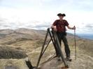
- Looking up to the trig on the "real?" South Rams Head
- The real one?
- Or is it really this one back up the ridge?