Heading to Darwin in a few months and I have gathered a little info on a walk I've been wanting to do for a while.
It's the Tabletop Circuit at Litchfield National Park. A 39km roundtrip via the major sights of Litchfield starting and finishing at either Florence or Wangi Falls.
It's closed during the wet season for obvious reasons and I guess the open date depends on the severity of the wet seasons rainfall.
http://www.nt.gov.au/nreta/parks/find/p ... ack_10.pdf
This PDF gives a idea of what the walk is about.
Has anyone done it, thinking of doing it or has any advise they could give me as a potential walk this dry season?
Any comments are appreciated.
Tabletop Walk - Litchfield NP
Forum rules
SA, WA & NT specific bushwalking discussion. Please avoid publishing details of access to sensitive areas with no tracks.
SA, WA & NT specific bushwalking discussion. Please avoid publishing details of access to sensitive areas with no tracks.
10 posts
• Page 1 of 1
Tabletop Walk - Litchfield NP
![]() by trickos » Wed 19 Jan, 2011 4:25 pm
by trickos » Wed 19 Jan, 2011 4:25 pm
-

trickos - Athrotaxis cupressoides

- Posts: 101
- Joined: Mon 08 Feb, 2010 2:55 pm
- Location: Geelong
- Region: Victoria
- Gender: Male
Re: Tabletop Walk - Litchfield NP
![]() by jez_au » Thu 20 Jan, 2011 8:34 am
by jez_au » Thu 20 Jan, 2011 8:34 am
Hi trickos, I did the Tabletop walk in July last year.
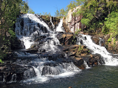
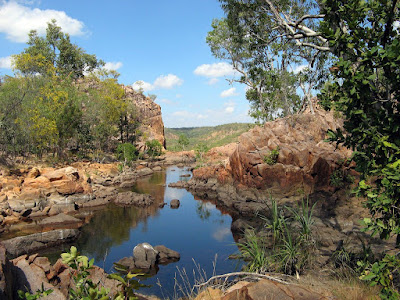
It's a great walk, savannah, woodland, waterfalls. Between Wangi and Walkers the track follows along the top edge of the escarpment, magnificent views, a few road-innaccessible waterfalls tumble 100m over the edge.
I did the walk in two days but would recommend taking a little more time (I was taken a little ill.) As always in the Top End walking in the morning and resting in the arvo is the best plan, it is very hot in the arvos out in the sun and away from water. About half of the track is through unshaded savannah.
You can access the track from any of the Link Walks - Florence Falls, Greenant Creek, Wangi Falls or Walker Creek. Many of the waterfalls on the link walks are crowded with people, but you'll appreciate the refreshing swim. Wangi is by far the biggest falls and tourist attraction, a fancy new visitor centre is under construction and they sell icecreams.
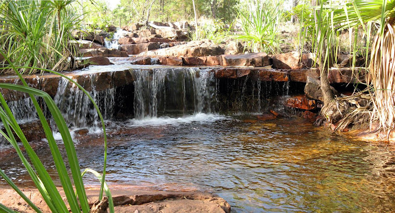
There are two very special campsites - one is marked on the map but apparently unnamed, 3km east of the Greenant Creek link walk. It is not accessible by vehicle, see photo below, shady camping, a single metal table. There is a toilet some distance back from the water, follow the placed-rock trail.
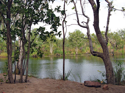
The second is Walker Creek. This one is popular, there are eight secluded campsites. It is at the carpark end of the link walk, but is a 750m to 1.5km walk from the carpark. The campsites are spread out over the 750m or so of creek. They each have their own rock pool, bit of creek and/or waterfall. Some are very private, some a bit closer and more visible to the main track. You cannot prebook, simply turn up early one morning (or on a quiet day) and write your name on the chalkboard just beyond the carpark (when someone has vacated their campsite and rubbed off their name). Walker Creek is the longest drive into the park from the Stuart Highway. If you walk in from the Tabletop Track the campsites start when you reach the toilet, to the left are sites 6 to 8, to the right the carpark and sites 1 to 5.
Here is a list of the sites, I didn't see a couple cos people were there:
Site 1. short driveway so little privacy, big pool, big falls
Site 2. no privacy
Site 3.
Site 4.
Site 5. no privacy, visible from track
Site 6. also day use area. big plunge pool. mulitple falls. toilet nearby.
Site 7. best campsite ever (of the ones I saw), huge plunge pool
Site 8. remote, small, creek access
I would recommend carrying the topo map stipulated by Parks & Wildlife. Like many Top End tracks the track can vary from being easy to follow to difficult, fire scarring will make the track difficult to follow. I got a little lost in a creek crossing between Wangi and the next campsite clockwise. I would usually have a GPS file to offer, but had lost my GPS unit just before this hike.
Another good rockhole for swimming is Buley Rockhole (or Buleys), it is not marked on the Tabletop map, it is just south of Florence Falls.
If you like, I have a blog entry here: http://jez-magneticnorth.blogspot.com/2010/07/litchfield.html
And some photos here: http://picasaweb.google.com/jez.blog/MagneticNorthLitchfield# (the first four photos are not on the track)
It's a great walk, savannah, woodland, waterfalls. Between Wangi and Walkers the track follows along the top edge of the escarpment, magnificent views, a few road-innaccessible waterfalls tumble 100m over the edge.
I did the walk in two days but would recommend taking a little more time (I was taken a little ill.) As always in the Top End walking in the morning and resting in the arvo is the best plan, it is very hot in the arvos out in the sun and away from water. About half of the track is through unshaded savannah.
You can access the track from any of the Link Walks - Florence Falls, Greenant Creek, Wangi Falls or Walker Creek. Many of the waterfalls on the link walks are crowded with people, but you'll appreciate the refreshing swim. Wangi is by far the biggest falls and tourist attraction, a fancy new visitor centre is under construction and they sell icecreams.
There are two very special campsites - one is marked on the map but apparently unnamed, 3km east of the Greenant Creek link walk. It is not accessible by vehicle, see photo below, shady camping, a single metal table. There is a toilet some distance back from the water, follow the placed-rock trail.
The second is Walker Creek. This one is popular, there are eight secluded campsites. It is at the carpark end of the link walk, but is a 750m to 1.5km walk from the carpark. The campsites are spread out over the 750m or so of creek. They each have their own rock pool, bit of creek and/or waterfall. Some are very private, some a bit closer and more visible to the main track. You cannot prebook, simply turn up early one morning (or on a quiet day) and write your name on the chalkboard just beyond the carpark (when someone has vacated their campsite and rubbed off their name). Walker Creek is the longest drive into the park from the Stuart Highway. If you walk in from the Tabletop Track the campsites start when you reach the toilet, to the left are sites 6 to 8, to the right the carpark and sites 1 to 5.
Here is a list of the sites, I didn't see a couple cos people were there:
Site 1. short driveway so little privacy, big pool, big falls
Site 2. no privacy
Site 3.
Site 4.
Site 5. no privacy, visible from track
Site 6. also day use area. big plunge pool. mulitple falls. toilet nearby.
Site 7. best campsite ever (of the ones I saw), huge plunge pool
Site 8. remote, small, creek access
I would recommend carrying the topo map stipulated by Parks & Wildlife. Like many Top End tracks the track can vary from being easy to follow to difficult, fire scarring will make the track difficult to follow. I got a little lost in a creek crossing between Wangi and the next campsite clockwise. I would usually have a GPS file to offer, but had lost my GPS unit just before this hike.
Another good rockhole for swimming is Buley Rockhole (or Buleys), it is not marked on the Tabletop map, it is just south of Florence Falls.
If you like, I have a blog entry here: http://jez-magneticnorth.blogspot.com/2010/07/litchfield.html
And some photos here: http://picasaweb.google.com/jez.blog/MagneticNorthLitchfield# (the first four photos are not on the track)
blogs - www.jeremyc.com
peak bagging - peakclimbs.com
peak bagging - peakclimbs.com
-

jez_au - Athrotaxis cupressoides
- Posts: 149
- Joined: Mon 24 May, 2010 1:45 am
- Region: South Australia
- Gender: Male
Re: Tabletop Walk - Litchfield NP
![]() by trickos » Thu 20 Jan, 2011 9:37 am
by trickos » Thu 20 Jan, 2011 9:37 am
Thanks heaps Jez,
I lived in Dawin for a couple of years 2003 - 2006 and loved Buley Rockhole....spent many a day there lazing about with a stubby in hand.
Its funny, now I've moved to Victoria, I have a geater interest in walking and regret not doing some great hiking such as this one and Jatbula etc.
I've camped at Walker Creek before - I know each camp has great access to rockholes but I could not remember the state of each campsite. All I remember is the little freshwater yabbies nibbling at my toes.
Sounds like theres plenty of options for creating a few short days and as you say resting in the arvo....preferrably in the water.
Thanks again, The photo whets my appetite even more.
-
trickos - Athrotaxis cupressoides
- Posts: 101
- Joined: Mon 08 Feb, 2010 2:55 pm
- Location: Geelong
- Region: Victoria
- Gender: Male
Re: Tabletop Walk - Litchfield NP
![]() by jez_au » Thu 20 Jan, 2011 9:48 am
by jez_au » Thu 20 Jan, 2011 9:48 am
No worries, you'll be sure to enjoy! I think the Jatbula Trail is a better track, more spectacular water, bit more diverse landscape, limited number of people - not an issue on the Tabletop Track itself (just the car-accessible waterfalls), but on the Jatbula you have the campsite's waterfalls/river to yourself or your own small party (no car access.) Almost all the campsites on the Jatbula are spectacular, walking in the morning, cooling off in and beside the water in the afternoons is sweet and easy.
For instance, these three campsites on the Jatbula, all yours:
Biddlecombe Cascades
Sandy Pool camp
17 Mile Falls
http://jez-magneticnorth.blogspot.com/2010/08/jatbula-trail.html
For instance, these three campsites on the Jatbula, all yours:
Biddlecombe Cascades
Sandy Pool camp
17 Mile Falls
http://jez-magneticnorth.blogspot.com/2010/08/jatbula-trail.html
blogs - www.jeremyc.com
peak bagging - peakclimbs.com
peak bagging - peakclimbs.com
-
jez_au - Athrotaxis cupressoides
- Posts: 149
- Joined: Mon 24 May, 2010 1:45 am
- Region: South Australia
- Gender: Male
Re: Tabletop Walk - Litchfield NP
![]() by north-north-west » Thu 20 Jan, 2011 6:13 pm
by north-north-west » Thu 20 Jan, 2011 6:13 pm
And don't forget Sweetwater Pool on the Jatbula - the last campsite and, although people can walk that far from Leliyn, hardly anyone does. It's one of my favourite places in the Territory.
I did Tabletop my first time through Litchfield, but don't remember much except the flies and the falls. And the goannas. There were a lot of goannas.
I did Tabletop my first time through Litchfield, but don't remember much except the flies and the falls. And the goannas. There were a lot of goannas.
"Mit der Dummheit kämpfen Götter selbst vergebens."
-

north-north-west - Lagarostrobos franklinii

- Posts: 15411
- Joined: Thu 14 May, 2009 7:36 pm
- Location: The Asylum
- ASSOCIATED ORGANISATIONS: Social Misfits Anonymous
- Region: Tasmania
Re: Tabletop Walk - Litchfield NP
![]() by trickos » Fri 21 Jan, 2011 7:11 am
by trickos » Fri 21 Jan, 2011 7:11 am
And the goannas. There were a lot of goannas.
The Cane Toads may have taken care of that.
-
trickos - Athrotaxis cupressoides
- Posts: 101
- Joined: Mon 08 Feb, 2010 2:55 pm
- Location: Geelong
- Region: Victoria
- Gender: Male
Re: Tabletop Walk - Litchfield NP
![]() by jez_au » Wed 25 May, 2011 11:18 am
by jez_au » Wed 25 May, 2011 11:18 am
There are GPS files available for this walk now. They come from http://en.travelnt.com/experience/walking-trekking/tabletop-track.aspx - I reconfigured the XML file as a GPX file and KML file. The path doesn't have a huge amount of points, but should be ample for navigating the trail should you wander off it (really only possible through burnt out areas or wide creek crossings.) I would place a caveat on the area around Walker Creek though, I'm not sure it looks correct, the trail goes from the main trail west to Walker Creek Campsite as a spur trail rather than the main trail passing through the carpark. If coming off the main trail you won't get lost, the spur meets to the carpark to campsites trail near the toilet, at about campsite 6 of 8. Turn left for sites 6-8, right for sites 1-5 and carpark.
http://www.jeremyc.com/2011/tabletop-track.gpx
http://www.jeremyc.com/2011/tabletop-track.kml
http://www.jeremyc.com/2011/tabletop-track.gpx
http://www.jeremyc.com/2011/tabletop-track.kml
blogs - www.jeremyc.com
peak bagging - peakclimbs.com
peak bagging - peakclimbs.com
-
jez_au - Athrotaxis cupressoides
- Posts: 149
- Joined: Mon 24 May, 2010 1:45 am
- Region: South Australia
- Gender: Male
Re: Tabletop Walk - Litchfield NP
![]() by tom_brennan » Wed 29 Jun, 2011 9:40 pm
by tom_brennan » Wed 29 Jun, 2011 9:40 pm
We were in Litchfield recently. I can't remember the all the details of the Walker Creek sites, but our ranking I think was
3, 7, 1, 2, 8, 5. It depends a bit on what you're after. 5 & 8 don't really have swimming holes at all - just creek access. Didn't see 4. 6 is fine except for sharing with the day use areas, but if you're only there overnight it's a good swimming hole. 7 & 8 are a bit close together, but you won't get other randoms walking past/through as they are right out the end of the track.
3, 7, 1, 2, 8, 5. It depends a bit on what you're after. 5 & 8 don't really have swimming holes at all - just creek access. Didn't see 4. 6 is fine except for sharing with the day use areas, but if you're only there overnight it's a good swimming hole. 7 & 8 are a bit close together, but you won't get other randoms walking past/through as they are right out the end of the track.
Bushwalking NSW - http://bushwalkingnsw.com
-

tom_brennan - Athrotaxis selaginoides

- Posts: 1417
- Joined: Wed 29 Sep, 2010 9:21 am
- Location: Sydney
- Region: New South Wales
- Gender: Male
Re: Tabletop Walk - Litchfield NP
![]() by Jason68 » Mon 29 Aug, 2011 8:28 pm
by Jason68 » Mon 29 Aug, 2011 8:28 pm
Just a qik update on trak. Just completed it, late wet so water is not an issue. Parked at Wangi, there is a 1300 registration number, however Nat Parks Batchelor weren't all that concerned wen I rang them 4 info? I only found out about 1300 from map? Trak easily followed, topo map advisable, available from Darwin Museum (only ppl had it). Did it in 2 days... Mistake... Slow down! Lol. Beautiful, diverse terrain, temps 35/7 ish during day & 20 o/nyt. Watch for snakes - active. Pickies available if required. Get out there! Did not see one other person?!
- Jason68
- Atherosperma moschatum

- Posts: 74
- Joined: Mon 29 Aug, 2011 7:39 pm
- Region: Northern Territory
- Gender: Male
Re: Tabletop Walk - Litchfield NP
![]() by trickos » Thu 01 Sep, 2011 7:58 am
by trickos » Thu 01 Sep, 2011 7:58 am
It's always great to see some pickies 
-
trickos - Athrotaxis cupressoides
- Posts: 101
- Joined: Mon 08 Feb, 2010 2:55 pm
- Location: Geelong
- Region: Victoria
- Gender: Male
10 posts
• Page 1 of 1
Return to South Australia, Western Australia & Northern Territory
Who is online
Users browsing this forum: No registered users and 2 guests