As the topic says- can anyone recommend an overnight or 2 night walk up near Broome?
I will be up there for ~5 days in January so thought it might be good 'training' with the heat and humidity for Kokoda (currently scheduled for 'one of these days'!)
I've never been to Broome before so not sure what to expect...
Cheers,
Will
Anyone done any hiking up in Broome?
Forum rules
SA, WA & NT specific bushwalking discussion. Please avoid publishing details of access to sensitive areas with no tracks.
SA, WA & NT specific bushwalking discussion. Please avoid publishing details of access to sensitive areas with no tracks.
4 posts
• Page 1 of 1
Anyone done any hiking up in Broome?
![]() by Empacitator » Fri 10 Dec, 2010 1:16 pm
by Empacitator » Fri 10 Dec, 2010 1:16 pm
-

Empacitator - Atherosperma moschatum

- Posts: 98
- Joined: Tue 13 Apr, 2010 5:10 pm
- Region: Western Australia
- Gender: Male
Re: Anyone done any hiking up in Broome?
![]() by stepbystep » Fri 10 Dec, 2010 2:14 pm
by stepbystep » Fri 10 Dec, 2010 2:14 pm
Hey Will,
Haven't been there but I understand some walks at Purnululu(bungle Bungle's) are stunning - a lot of time can be spent in the shade of the 'beehives' and there is nice camping, with water in places like this pic.
Otherwise Cape Leveque looks stunning, I have friends that have camped there for weeks at a time, and they go every year for 20+ years - must be nice! See pic
Bare in mind everywhere up there is a long way from anywhere so you would need a vehicle and LOTS of water.
Haven't been there but I understand some walks at Purnululu(bungle Bungle's) are stunning - a lot of time can be spent in the shade of the 'beehives' and there is nice camping, with water in places like this pic.
- Cathederal-Bungle%20Bungles%20NP.jpg (35.28 KiB) Viewed 7935 times
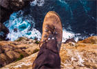
Otherwise Cape Leveque looks stunning, I have friends that have camped there for weeks at a time, and they go every year for 20+ years - must be nice! See pic
- Cape-Leveque.jpg (25.55 KiB) Viewed 7935 times
Bare in mind everywhere up there is a long way from anywhere so you would need a vehicle and LOTS of water.
The idea of wilderness needs no defense, it only needs defenders ~ Edward Abbey
-
stepbystep - Lagarostrobos franklinii

- Posts: 7707
- Joined: Tue 19 May, 2009 10:19 am
- Location: Street urchin
- Region: Tasmania
- Gender: Male
Re: Anyone done any hiking up in Broome?
![]() by jez_au » Fri 10 Dec, 2010 3:48 pm
by jez_au » Fri 10 Dec, 2010 3:48 pm
Hi Will, there are a couple of options.
In Broome there is the six-day 72km Lurujarri Heritage Trail or Lurujarri Dreaming Trail. It starts at the lighthouse at Gantheaume Point, a few kilometres south west of central Broome (south of Cable Beach.) It heads north to Minarriny (Coulomb Point), following the coast (Cape Leveque is further north.) It passes over James Price Point, the controversial site of the WA Govt's proposed Kimberley gas processing plant. I have not walked this, but the beaches are beautiful, as is James Price Point. The trail is available for use to independent walkers or guided tours - the guided tours are done by the local Aboriginal folk, it is a dreaming song trail. Saltie Crocs would present a minor risk, they are known to move along the coast here (they pose little threat when moving along the coast.) Tourist campsites/hotels along this strip claim to be croc free, but there are croc sighting tales. You would need to keep well clear of the sea though due to the box jellyfish (or something like that, I dont' remember, but something small in the January water is deadly).
The official leaflet for the trail is here: http://tourism.heritage.wa.gov.au/ht_pdf/Lurujarri.pdf
The offical website for the guided tour is here: http://www.environskimberley.org.au/lurujarri/lht_walking.htm
As stepbystep has mentioned, there is good walking in Purnululu. I did a 2-day walk into Piccaninny Gorge in the Bungle Bungle, a 3 or 4 day walk is possible by exploring the 'fingers' past 'The Elbow'. It is possible to do as a 1 day walk too (a long day.) However Purnululu National Park is over 700km east of Broome along National Highway 1, a high-clearance 4WD (think 4WD not All-Wheel-Drive) may be required to drive the 100km (2 hours) from the highway into the park. *May* should probably read *will* be required, January is the Wet Season, you would need to check if the park is even open (I think it closes in the Wet.)
I have a blog entry here if it interests you: http://jez-magneticnorth.blogspot.com/2010/07/bungle-bungle.html
Official national park brochure is here (refer to page 4): http://www.dec.wa.gov.au/index2.php?option=com_docman&task=doc_view&gid=4241&Itemid=847
I was here mid this year, I am not aware of any other hiking nearby. Mitchell Falls is north of the Gibb River Road, but again this is many, many hundreds of kilometres from Broome (Mitchell Falls itself is on a poor quality dirt road, some 5 hours drive north of the Gibb River Road, strictly 4WD territory, and not recommended during the Wet. Flying is possible. But the walking trail is only a days walk return, and again, not open during the Wet).
If there are any other walking opportunities I would be keen to know. There are short half-day/a few hours walks along the Gibb River Road (difficult access in the Wet.)
blogs - www.jeremyc.com
peak bagging - peakclimbs.com
peak bagging - peakclimbs.com
-

jez_au - Athrotaxis cupressoides

- Posts: 156
- Joined: Mon 24 May, 2010 1:45 am
- Region: South Australia
- Gender: Male
Re: Anyone done any hiking up in Broome?
![]() by Empacitator » Fri 10 Dec, 2010 6:14 pm
by Empacitator » Fri 10 Dec, 2010 6:14 pm
Thanks for the information guys I will do some reading on these places  They do sound fantastic
-
Empacitator - Atherosperma moschatum
- Posts: 98
- Joined: Tue 13 Apr, 2010 5:10 pm
- Region: Western Australia
- Gender: Male
4 posts
• Page 1 of 1
Return to South Australia, Western Australia & Northern Territory
Who is online
Users browsing this forum: No registered users and 8 guests