Hi
An update on the walk we did.
It took us 14 days of walking, plus one rest day at Ormiston.
Food drops were at Ellery and at Ormiston, these were done by Glen Helens, we dropped the parcels into a central point in ALice, then they took them from there, the cost was $25 per drop. Very reasonable we thought. This allowed us to walk the trail from East to West.
Water was mostly in the Parks tanks, but there were some natural sources that we used for camping away from the usual spots. Millers Flat, Fringed Lilly Ck. For the nights spent up on the ranges, such as Brinkely Bluff we carried water, well worth it.
Phone reception - Brinkely Bluff had excellent 3G reception for the Optus network and I managed to do a few emails and check the weather site. We did not have Telstra sim cards, but those with them said they got reception furthur west, I think Telstra have a tower in the Fink area to the south of Redbank (look at the service maps on their site).
Snakes - did not see any.
Flies - not enought to worry about, did not need nets or repellent.
Mozzies - a few in the evenings in various locations, most oddly on top of Brinkley Bluff ??
Frost - we did not have our first frost until the last two nights, when we had a minus 2 then a minus 3 degrees.
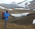
Geology - this was one of the most interesting things about the area. Do a bit of home work before you go or takes a book relevent to the region so you can interpret what you are seeing.
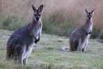
Wildlife - some Euros, rock wallabies, a couple of Lizzards (bit cold for them). We did not see any Dingos in the daylight though they did come around our tent on several nights.
UV Steripen - the best way to treat the water on route. We have been using them trekking in Nepal for 4 seasons.
At Redbank we walked out to the main road, about 5km (easy). Put the packs on the ground & heard a car coming, thumbs out and volia we had a life with some mining people returning to Alice. We would not have been there 2 mins ! Beats paying $300 for the transport. But perhaps we were lucky.
In reflection we believe the East to West direction is preferable if you can do it, the trail seems to climb the hills more gradually in that direction, plus you get to Mt Sonder at the end of the walk.
Thanks for the earlier tips.