Mt Barney All peaks
Forum rules
Queensland specific bushwalking discussion. Please avoid publishing details of access to sensitive areas with no tracks.
Queensland specific bushwalking discussion. Please avoid publishing details of access to sensitive areas with no tracks.
10 posts
• Page 1 of 1
Mt Barney All peaks
![]() by smannysmith » Sun 14 Apr, 2024 5:25 pm
by smannysmith » Sun 14 Apr, 2024 5:25 pm
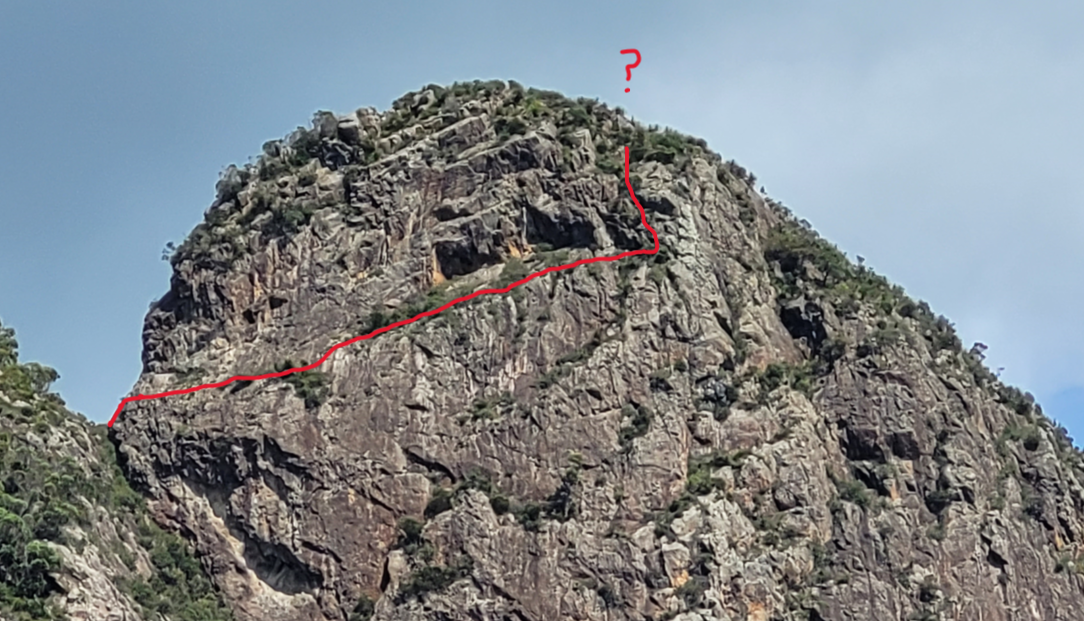
Yesterday a mate and I did the Eagle's Ridge/ Barney traverse, which got me thinking whether anyone has tried doing all of the Mt Barney peaks, including Leaning Peak via the Comino-Waring ledge? I figure it would be possible to do everything on the mountain this way without backtracking, or descending too much: Eagles ridge (bagging all of the Tom's Tums and Isolated peak), then up Comino-Waring ledge to get to Leaning peak, abseil down, North peak, East peak, across to West Peak, then down midget ridge to Bippoh peak, then back out to lower portals carpark. I imagine doing this entire hike with a bunch of climbing equipment would be a massive pain and ideally it would be great to know the minimum safe amount of gear necessary to climb the ledge. At Euwbanks 12, it doesn't sound particularly difficult, but from what I understand this part of Leaning Peak has very chossy rock, so the danger factor is real. In Secrets of the Scenic Rim, Robert Rankin does a slightly different route, approaching Isolated Peak up Moonlight slabs, then arduously traverses the saddle between Isolated and Leaning peak. I reckon never actually descending the mountain to gain Leaning Peak would be an awesome experience, but there aren't any modern accounts of this. Has anyone on here ever done this, and where exactly does the ledge go? I took a photo yesterday and figured this would be the path of least resistance:
- smannysmith
- Nothofagus cunninghamii

- Posts: 1
- Joined: Tue 14 Dec, 2021 1:44 pm
- Region: Queensland
- Gender: Male
Re: Mt Barney All peaks
![]() by Ain » Mon 22 Apr, 2024 11:40 am
by Ain » Mon 22 Apr, 2024 11:40 am
Stoked when I see a post like this! Been a project of mine for quite some time and I'm close to an attempt!
I have been out on the Comino-Waring Ledge a couple of times, first traversing to the far side. It's extremely exposed, and my heart was in my mouth the whole way there and back, although the traverse alone isn't difficult. Also, I believe the rock quality isn't as bad as others have reported, but still slightly worse than the rest of Mt Barney because of lack of traffic, lichen, sun exposure, etc. There is a safe platform between the rockface and a tree at the far end, from which the climb up begins. The second time I went out, I abseiled from the top and practised the climb on belay. A lot of shrubs got in the way and I found myself relying on vegetation for holds, so it's obviously not something I'd do unprotected as that stuff could give out. The Ledge is definitely achieveable, but presents a logistical challenge for protecting yourself.
An alternative is to take Chockstone Gully up to Short Leaning Ridge, then Leaning Peak. I'm yet to evaluate whether this is a more viable path than the Ledge and its timesink of ropework, assuming you have the endurance to not mind doing a bit more distance and elevation to take the Gully. I believe this is the route Robert Rankin took on his Barney all-peaks day.
There is mention of (probably) the first completion of the all-peaks circuit in Robert Rankin's Secrets of the Scenic Rim, pp. 168-169, in 1964 by Alan Frost, Tim Cassidy and Barry Smith. They did the 7 peaks you mentioned, which is rarely seen. I have seen plenty of people complete a 6-peak circuit on Barney and leave out Leaning Peak.
However, in my opinion, the true Barney all-peaks day involves 10 peaks with the inclusion of Barrabool, Burrajum and Gwyala peaks, as they are 1) part of the same geological granophyre massif as the rest, with Mount Barney Creek dividing the Ballow massif from the Barney massif 2) at a similar elevation to the other peaks, with Mount Barney Creek constituting a massive drop in elevation that separates them from the Ballow massif peaks. The far western peaks make doing a Barney all-peaks day into quite an endurance challenge, as they are quite a long detour and sheathed in thick vegetation. The 10 peaks are especially visible from Mt Maroon:
I haven't found any record of anyone doing the whole 10 within a day, although I wouldn't doubt that it's been done over a few days in the past. I'll have to ask some public groups whether it's actually not been done. As I said at the start, this has been a project of mine for some time and I think I'll get it completed in the next month of two, once I find enough free time to do so.
I have been out on the Comino-Waring Ledge a couple of times, first traversing to the far side. It's extremely exposed, and my heart was in my mouth the whole way there and back, although the traverse alone isn't difficult. Also, I believe the rock quality isn't as bad as others have reported, but still slightly worse than the rest of Mt Barney because of lack of traffic, lichen, sun exposure, etc. There is a safe platform between the rockface and a tree at the far end, from which the climb up begins. The second time I went out, I abseiled from the top and practised the climb on belay. A lot of shrubs got in the way and I found myself relying on vegetation for holds, so it's obviously not something I'd do unprotected as that stuff could give out. The Ledge is definitely achieveable, but presents a logistical challenge for protecting yourself.
- Comino-Waring Ledge, climbing up the far end
An alternative is to take Chockstone Gully up to Short Leaning Ridge, then Leaning Peak. I'm yet to evaluate whether this is a more viable path than the Ledge and its timesink of ropework, assuming you have the endurance to not mind doing a bit more distance and elevation to take the Gully. I believe this is the route Robert Rankin took on his Barney all-peaks day.
- Leaning Peak Chockstone Gully
There is mention of (probably) the first completion of the all-peaks circuit in Robert Rankin's Secrets of the Scenic Rim, pp. 168-169, in 1964 by Alan Frost, Tim Cassidy and Barry Smith. They did the 7 peaks you mentioned, which is rarely seen. I have seen plenty of people complete a 6-peak circuit on Barney and leave out Leaning Peak.
However, in my opinion, the true Barney all-peaks day involves 10 peaks with the inclusion of Barrabool, Burrajum and Gwyala peaks, as they are 1) part of the same geological granophyre massif as the rest, with Mount Barney Creek dividing the Ballow massif from the Barney massif 2) at a similar elevation to the other peaks, with Mount Barney Creek constituting a massive drop in elevation that separates them from the Ballow massif peaks. The far western peaks make doing a Barney all-peaks day into quite an endurance challenge, as they are quite a long detour and sheathed in thick vegetation. The 10 peaks are especially visible from Mt Maroon:
- Barney 10 peaks annotated from Maroon
I haven't found any record of anyone doing the whole 10 within a day, although I wouldn't doubt that it's been done over a few days in the past. I'll have to ask some public groups whether it's actually not been done. As I said at the start, this has been a project of mine for some time and I think I'll get it completed in the next month of two, once I find enough free time to do so.
- Ain
- Nothofagus cunninghamii
- Posts: 5
- Joined: Fri 28 Apr, 2023 4:44 pm
- Region: Queensland
- Gender: Male
Re: Mt Barney All peaks
![]() by keithj » Sat 27 Apr, 2024 10:36 am
by keithj » Sat 27 Apr, 2024 10:36 am
10 peaks would be interesting 
Not being a local, I have some questions....
I assume these are the 10 peaks ? Taken from Opentopo.
And there are 2 route options - starting at Yellow Pinch or at Lower Portals ?
Parks seems to suggest there is a track to the Remote Bush Camp at Burrajum - is it reasonable ?
Is there a route to Gwyalia ?
The route marked in red goes cross country to Isolated Peak/NE Rock - doable ? or stick to the ridges ?
- keithj
- Athrotaxis cupressoides

- Posts: 189
- Joined: Sun 01 Nov, 2015 7:27 pm
- Region: New South Wales
- Gender: Male
Re: Mt Barney All peaks
![]() by Aardvark » Sat 27 Apr, 2024 9:04 pm
by Aardvark » Sat 27 Apr, 2024 9:04 pm
You're all dreaming. Seven in a day would likely ever be the maximum.
It would still require consensus as to what completes the journey.
ie. Is a circuit necessary? What are the boundaries of a day? eg can you include night time? Starting before dawn and finishing after dusk.
The only practical route takes in Lower Portals and maybe Upper Portals ( if you include Gwyala Peak ).
That should take into account the 5k walk in from Lower Portals carpark or the exit out via Cleared Ridge, or the return between Upper and Lower Portals whether via Barney Ck or the track system just to the north.
Bippo Peak and Toms Tum are minor peaks which are simply collected by travelling Eagles Ridge and Midget Ridge.
Ever on the search for a one ended stick.
- Aardvark
- Athrotaxis cupressoides
- Posts: 444
- Joined: Sat 28 Jul, 2012 6:15 am
- Region: Queensland
- Gender: Male
Re: Mt Barney All peaks
![]() by Ain » Sat 27 Apr, 2024 10:43 pm
by Ain » Sat 27 Apr, 2024 10:43 pm
@keithj There is no track to Burrajum or Gwyala. It's very thick bush bashing out that way and few people go. Your marked route isn't doable — there's several cliff breaks to navigate that aren't visible on that map (try QTopo for higher res contour lines). Here's a very rough scribble of the route I'm taking:
@Aardvark Give me a few weeks and, if the closures in the national park have ended by then, I'll see if I can do the 10 within 24 hours.
- Mt Barney 10 peaks rough route
@Aardvark Give me a few weeks and, if the closures in the national park have ended by then, I'll see if I can do the 10 within 24 hours.
- Ain
- Nothofagus cunninghamii
- Posts: 5
- Joined: Fri 28 Apr, 2023 4:44 pm
- Region: Queensland
- Gender: Male
Re: Mt Barney All peaks
![]() by smannysmith » Sun 28 Apr, 2024 10:52 am
by smannysmith » Sun 28 Apr, 2024 10:52 am
@Ain thanks for the extra reference in secrets of the scenic rim, didn't realise there was another story about the Comino Waring Ledge in there. All the best on your trip, would love to see a report afterwards! I agree that the 10 peaks represents the true All-Peaks challenge, though personally, I don't think I'd have the mental fortitude to do it in a 24hr period (Bush Bashing your way between the western peaks in the dark doesn't sound particularly appealing). The first half of the trip looks wonderful, but after West Peak it looks heinus. In my mind a 2 day journey, with a bivy on West Peak would allow for more time to do Comino-Waring Ledge, plus taking in Eagles' Slabs which is a personal favourite...
- smannysmith
- Nothofagus cunninghamii
- Posts: 1
- Joined: Tue 14 Dec, 2021 1:44 pm
- Region: Queensland
- Gender: Male
Re: Mt Barney All peaks
![]() by Aardvark » Sun 28 Apr, 2024 1:34 pm
by Aardvark » Sun 28 Apr, 2024 1:34 pm
Alright. I'll concede that 24 hrs would make it possible.
Just a few points though.
Why aren't you including Savages Peak? Just because some maps don't mention it ? It terms of height it probably rates more of a mention than Toms Tum or even Bippo.
And are you really climbing Toms Tum?. Isn't the summit of it bypassed somewhat?
I agree the route between Burrajum and Gwyala is horrendous. Even Savages to Burrajum leaves something to be desired. I'm not sure if the last fire made that a bit simpler but i doubt it. Gwyala to Upper Portals isn't as bad.
If you forego Bippo, and add Savages, then return from Gwyala to Upper Portals. The route from the Upper Portals to link up with your track north of where you come out of Barney Gorge has a good footpad. It's quick travel. Still ten peaks.
The line you've drawn east from Gwyala Peak? Have you done that across there? Is it really quicker than back via the tops. (ie. ridgeline)?
I know Burrajum and Gwyala have some height but they really are separate from the main peaks.
If time is tight when you get to West Peak or your enthusiasm is waning, you could descend to Savages, pop around to Barrabool and go out via Bippo and still claim nine.
Ever on the search for a one ended stick.
- Aardvark
- Athrotaxis cupressoides
- Posts: 444
- Joined: Sat 28 Jul, 2012 6:15 am
- Region: Queensland
- Gender: Male
Re: Mt Barney All peaks
![]() by keithj » Mon 29 Apr, 2024 9:21 am
by keithj » Mon 29 Apr, 2024 9:21 am
Thanks for the info ain , aardvark, smanny.
This route going anti clockwise gets the bushbashing in the West over with early and leaves a couple of options to abort later. It also includes Mt Savage. I assume Mt Savage is 500m SW of West Peak and only 40m above the saddle?
It's probably less than 30km and minimises the vert.
Interpreting the posts above - the Leaning Peak out & back that I've marked is up is Chockstone Gully (copied from ains route) ? and therefore avoids carrying ropes ? The crag https://www.thecrag.com/en/climbing/aus ... e/12192433 route description looks doable.
And is there water anywhere up there ?
There is a record of a triple ascent using Barney Gorge Ck and the 3 SE routes - total of 55km & 4K of ascent taking 18 hours. It included E & W Peaks multiple times.
Last edited by keithj on Mon 29 Apr, 2024 12:30 pm, edited 1 time in total.
- keithj
- Athrotaxis cupressoides
- Posts: 189
- Joined: Sun 01 Nov, 2015 7:27 pm
- Region: New South Wales
- Gender: Male
Re: Mt Barney All peaks
![]() by Ain » Mon 29 Apr, 2024 11:18 am
by Ain » Mon 29 Apr, 2024 11:18 am
@Aardvark I'll include Savages Peak in my run, it should be only a 15 minute detour. But I'll only count it as an unofficial peak because it feels more like it should be referred to as a 'knoll'. To call it a peak lessens the significance of the other surrounding peaks. I initially didn't include it because it's not very prominent and there's no challenge in getting to it, and yes because it's not mentioned on most maps. And yes, I'm scrambling up to the highest point on Toms Tum, I don't do the bypass.
I have done the shortcut back east from Gwyala that was draw in my map above and it is drastically faster. Once you descend out of bushfire-affected eucalypt forest into permanent rainforest, travel is much faster and you also shave some distance off by taking a direct route back. The only reason to do the ridgeline is to hit Burrajum Peak.
@keithj Very interesting route! Whilst doing it anti-clockwise gets some bush bashing over with early, I'd personally do it clockwise on a 24-hours run to avoid scrambling the rockfaces of Leaning Peak, Eagles Slabs and Toms Tum in the dark. Bush bashing in the dark beats scrambling in the dark, in my opinion. Rock hopping Mount Barney Creek is also deceptively slow going, so I think walking up to Cleared Ridge fire trail then descending south to Upper Portals before starting Gwyala Ridge would be a faster route. I seriously considered this loop and, while I admit it looks a whole lot more aesthetic than what I've drawn above, I think it would be slightly slower to get all the way back to Lower Portals carpark which is my goal.
- Ain
- Nothofagus cunninghamii
- Posts: 5
- Joined: Fri 28 Apr, 2023 4:44 pm
- Region: Queensland
- Gender: Male
Re: Mt Barney All peaks
![]() by keithj » Mon 29 Apr, 2024 1:45 pm
by keithj » Mon 29 Apr, 2024 1:45 pm
ain. Thks for that - shooting down bad plans is very much appreciated . Next route plan looks v. similar to yours.
Variations being -
1) Leaning Peak is an out & back via Chockstone Gully(?) to avoid 50m abseil. I don't know where Comino-Waring Ledge is or if it would be a useful option.
2) Take your direct route between West/Savage & Gwyala but in opposite direction and while en-route assess if it's easier to return mostly that way & then ascend Burrajum from the N/NW. The alternative is follow the ridge from Gwyala to Burrajum with its' known dense bush.
- keithj
- Athrotaxis cupressoides
- Posts: 189
- Joined: Sun 01 Nov, 2015 7:27 pm
- Region: New South Wales
- Gender: Male
10 posts
• Page 1 of 1
Who is online
Users browsing this forum: No registered users and 11 guests