I am planning a 3 night trek and have a few questions. This is in April.
Planning to do a loop from Upper Howqua Camping Area, going up Helicopter Spur, past Magdala, out and back The Crosscut Saw, then back down Howitt Spur or Stanleys Name Spur and Queen Spur.
Concerned with a guaranteed water point to camp near King Billy or just past Magdala at this time of year, any suggestions?
Also wondering if it is too much to walk out and back the Crosscut to Speculation in one day? i want to enjoy it. Thinking of camping at Macalister Springs and instead of back tracking all the way we could camp next night on Stanleys Name Spur, 1km in with the water point.
Suggestions would be great, thanks.
Emma
Helicopter Spur and Crosscut Saw in April
Forum rules
Victoria specific bushwalking discussion. Please avoid publishing details of access to sensitive areas with no tracks.
Victoria specific bushwalking discussion. Please avoid publishing details of access to sensitive areas with no tracks.
35 posts
• Page 1 of 2 • 1, 2
Helicopter Spur and Crosscut Saw in April
![]() by HobieEm » Thu 18 Mar, 2021 7:33 am
by HobieEm » Thu 18 Mar, 2021 7:33 am
- HobieEm
- Nothofagus cunninghamii

- Posts: 5
- Joined: Wed 17 Mar, 2021 3:00 pm
- Region: Victoria
- Gender: Female
Re: Helicopter Spur and Crosscut Saw in April
![]() by Lophophaps » Thu 18 Mar, 2021 9:32 am
by Lophophaps » Thu 18 Mar, 2021 9:32 am
Emma, see
https://www.bushwalk.com/forum/viewtopi ... 37&t=32780
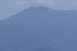
for details of the water on Stanleys Name Spur. The February edition of the magazine had a trip report of what you intend. It's possible to go from Mac Springs to Spec and back in a day, but it could be a bit long for some people. If the weather is fine there are small slightly exposed campsites on the Howitt treeline going to Mac Springs. One is shown below. The views are amazing at dawn and dusk. The track is just below the tent, with Howitt behind.
https://www.bushwalk.com/forum/viewtopi ... 37&t=32780
for details of the water on Stanleys Name Spur. The February edition of the magazine had a trip report of what you intend. It's possible to go from Mac Springs to Spec and back in a day, but it could be a bit long for some people. If the weather is fine there are small slightly exposed campsites on the Howitt treeline going to Mac Springs. One is shown below. The views are amazing at dawn and dusk. The track is just below the tent, with Howitt behind.
- Howitt treeline camp
-
Lophophaps - Auctorita modica

- Posts: 3467
- Joined: Wed 09 Nov, 2011 9:45 am
- Region: Victoria
- Gender: Male
Re: Helicopter Spur and Crosscut Saw in April
![]() by HobieEm » Thu 18 Mar, 2021 10:01 am
by HobieEm » Thu 18 Mar, 2021 10:01 am
Thanks for your insight,
any knowledge on water and camping near top of Helicopter Sp?
May have to detour to Lovicks hut!
any knowledge on water and camping near top of Helicopter Sp?
May have to detour to Lovicks hut!
- HobieEm
- Nothofagus cunninghamii
- Posts: 5
- Joined: Wed 17 Mar, 2021 3:00 pm
- Region: Victoria
- Gender: Female
Re: Helicopter Spur and Crosscut Saw in April
![]() by Lophophaps » Thu 18 Mar, 2021 11:26 am
by Lophophaps » Thu 18 Mar, 2021 11:26 am
Emma, I have no knowledge of water at the top of Helicopter Spur. The article I referred to is in the magazine, home screen on this website, right side, down a bit, cover of a lovely curved track. From the top of Helicopter Spur it's downhill 100 metres and a long kilometre to Lovicks Hut, without the certainty that the tank will have water. You have to come back up the hill! In my view it's better to push on to King Billy, up about 80 metres and 1.5 kilometres. If that water is absent then it's about 1.5-2 hours to the Magdala campsite.
It's possible that the water will be more reliable after precipitation.
It's possible that the water will be more reliable after precipitation.
-
Lophophaps - Auctorita modica
- Posts: 3467
- Joined: Wed 09 Nov, 2011 9:45 am
- Region: Victoria
- Gender: Male
Re: Helicopter Spur and Crosscut Saw in April
![]() by Heremeahappy1 » Thu 18 Mar, 2021 11:30 am
by Heremeahappy1 » Thu 18 Mar, 2021 11:30 am
FYI, no water tank at Lovicks hut.
- Heremeahappy1
- Athrotaxis cupressoides

- Posts: 218
- Joined: Tue 21 Nov, 2017 6:26 am
- Location: Gippsland
- Region: Victoria
- Gender: Male
Re: Helicopter Spur and Crosscut Saw in April
![]() by Baeng72 » Thu 18 Mar, 2021 12:19 pm
by Baeng72 » Thu 18 Mar, 2021 12:19 pm
I'm unable to find the post/thread, but apparently when you get to the top of the Helicopter Spur, there's a nearby dam, apparently beloved of Deer. There is also a creek near the King Billies, which may not be viable at the moment.
I'll keep searching to see if I can find it.
Found it, I think....
The first comment on this thread has a picture with these water sources...
viewtopic.php?f=46&t=32419&p=405509&hilit=helicopter+spur
BigKev recently was up Stanley Name Spur and the Crosscut Saw, so he'd have good info on water on SNS.
- Baeng72
- Athrotaxis selaginoides

- Posts: 1217
- Joined: Wed 07 Aug, 2019 2:29 pm
- Region: Victoria
- Gender: Male
Re: Helicopter Spur and Crosscut Saw in April
![]() by CraigVIC » Thu 18 Mar, 2021 12:42 pm
by CraigVIC » Thu 18 Mar, 2021 12:42 pm
If the weather is favourable I think it should be quite possible to carry water to get through to SNS. The Crosscut out and back would make that less viable.
- CraigVIC
- Phyllocladus aspleniifolius

- Posts: 629
- Joined: Tue 24 Oct, 2017 6:20 pm
- Region: Victoria
- wander
- Phyllocladus aspleniifolius
- Posts: 943
- Joined: Mon 26 Oct, 2009 11:19 am
- Region: South Australia
- Gender: Male
Re: Helicopter Spur and Crosscut Saw in April
![]() by wander » Thu 18 Mar, 2021 2:57 pm
by wander » Thu 18 Mar, 2021 2:57 pm
This map has the water point you seek marked.
- wander
- Phyllocladus aspleniifolius
- Posts: 943
- Joined: Mon 26 Oct, 2009 11:19 am
- Region: South Australia
- Gender: Male
Re: Helicopter Spur and Crosscut Saw in April
![]() by Avatar » Fri 19 Mar, 2021 12:39 am
by Avatar » Fri 19 Mar, 2021 12:39 am
if it is too much to walk out and back the Crosscut to Speculation in one day?
It's a big day with time pressure for light and that means you need lots of water. Allow 10 hours although others may be faster. Enjoyed lunch at Spec.
I did it carrying 4.5 litres and temps of about 16deg.
Ran out of water at the highest point on way back and suffered low electrolytes.
Need to watch for the signs (lethargy and hard to lift legs) and stop and treat early, for which you need plenty of water and some electrolyte sachets.
I had some cheese and food but it wasn't enough for the job.
Suggest you carry at least an extra 1.5l+ water and deposit on Mt Buggery for return.
Or just return at Mt. B.
-
Avatar - Athrotaxis cupressoides
- Posts: 322
- Joined: Sun 07 Jul, 2013 5:21 pm
- Location: NE Melbourne
- Region: Victoria
Re: Helicopter Spur and Crosscut Saw in April
![]() by bigkev » Fri 19 Mar, 2021 5:43 am
by bigkev » Fri 19 Mar, 2021 5:43 am
Avatar wrote:if it is too much to walk out and back the Crosscut to Speculation in one day?
It's a big day with time pressure for light and that means you need lots of water. Allow 10 hours although others may be faster. Enjoyed lunch at Spec.
I did it carrying 4.5 litres and temps of about 16deg.
Ran out of water at the highest point on way back and suffered low electrolytes.
Need to watch for the signs (lethargy and hard to lift legs) and stop and treat early, for which you need plenty of water and some electrolyte sachets.
I had some cheese and food but it wasn't enough for the job.
Suggest you carry at least an extra 1.5l+ water and deposit on Mt Buggery for return.
Or just return at Mt. B.
Yes, it's a solid days walking. Being an out and back job just set a time were you need to turn back (and stick to it
As far as water goes I was up on Stanley Name a couple of weeks ago and there is a good flow. If you descend Stanley Name be prepared for a bit of scrub.
There is camping at the top of Helicopter Spur - just make sure you find a spot before you hit the open 4wd track as it's a bit of a bogan magnet. As far as I know there isn't a reliable water source around the top of Helicopter Spur. There is sometimes water on or near the 4wd track that sidles the King Billies although I'd be pushing on to Macalister Springs... it would be worth checking out Hellfire Creek on the way past as it's a truly beautiful spot and it may?? have some water if there has been some recent rain (looking at the BOM forecast it's a possibility).
Cheers
-
bigkev - Athrotaxis cupressoides
- Posts: 445
- Joined: Sat 30 Jun, 2012 6:44 pm
- Region: Victoria
- Gender: Male
Re: Helicopter Spur and Crosscut Saw in April
![]() by Xplora » Fri 19 Mar, 2021 6:12 am
by Xplora » Fri 19 Mar, 2021 6:12 am
Avatar wrote:if it is too much to walk out and back the Crosscut to Speculation in one day?
It's a big day with time pressure for light and that means you need lots of water. Allow 10 hours although others may be faster. Enjoyed lunch at Spec.
I did it carrying 4.5 litres and temps of about 16deg.
Ran out of water at the highest point on way back and suffered low electrolytes.
Need to watch for the signs (lethargy and hard to lift legs) and stop and treat early, for which you need plenty of water and some electrolyte sachets.
I had some cheese and food but it wasn't enough for the job.
Suggest you carry at least an extra 1.5l+ water and deposit on Mt Buggery for return.
Or just return at Mt. B.
I am with you on this. April days are much shorter and weather is fickle. My suggestion (to add to yours) would be to drop a stash of water for the trip back before climbing up Buggery on the way in. With a light pack and a quick pace (quick enough to enjoy) it can be done in 8 hours or better. Last reports from Hellfire creek indicated a trickle from memory but that could be enough. Hope you are fit. This is a lot of walk in three days. Forget Queen Spur. Maybe take your gear to the top of SNS and drop most of it. Day pack it to Spec and camp at SNS on your return. You will have water and a good campsite plus a bit closer than Mac Springs. Should save you more than an hour.
- Xplora
- Athrotaxis selaginoides
- Posts: 1662
- Joined: Sat 01 Aug, 2015 7:24 am
- Region: Victoria
- Gender: Male
Re: Helicopter Spur and Crosscut Saw in April
![]() by paidal_chalne_vala » Fri 19 Mar, 2021 6:56 am
by paidal_chalne_vala » Fri 19 Mar, 2021 6:56 am
Xplora makes a good suggestion.
I generally don't walk in this area in Autumn because finding water becomes tricky . Late Spring is the best time of the year for the Buller/Howitt area. However
friends and I did walk up SNS and camp at Mac. Springs in March 2020 . We knew there would be water on Queens Spur track , SNS and at Mac Springs and carried enough to get us down the Howitt spur to the Upper Howqua river.
April on the Bogong High Plains would have better water options but the days are becoming shorter and snow and fog in April in the Vic. high country are not unusual .
My understanding is the water in Hellfire Creek dries up after Xmas. It is mostly a seasonal stream.
The only water I know near King Billy that might be flowing in April would be a spring/ trickle on the locked gate management track going towards Mt. Clear , about 500 M up from King Billy Saddle where Brocks road and the King Billy Track meet.
Easter at Mac Springs will be dreadfully busy and far from peaceful and relaxed. The 4 WD tracks out there won't be deserted either.
- paidal_chalne_vala
- Lagarostrobos franklinii

- Posts: 2733
- Joined: Sun 22 Jan, 2012 10:30 pm
- ASSOCIATED ORGANISATIONS: VNPA.BTAC.Friends of Baw Baw.Mt.Bogong Club.
- Region: Victoria
- Gender: Male
Re: Helicopter Spur and Crosscut Saw in April
![]() by HobieEm » Fri 19 Mar, 2021 5:50 pm
by HobieEm » Fri 19 Mar, 2021 5:50 pm
Xplora- you mention " forget Queens spur ", why as i wanted to get back to Upper Howqua camping area?
I like the idea of basing at SNS as its just a little closer and carry just day gear on crosscut, turning around at a specified time.
But then something tells me am i stupid going in April with no guaranteed water sources and don't think i can carry enough. Maybe i should stay lower and do this amazing trek another time?
- HobieEm
- Nothofagus cunninghamii
- Posts: 5
- Joined: Wed 17 Mar, 2021 3:00 pm
- Region: Victoria
- Gender: Female
Re: Helicopter Spur and Crosscut Saw in April
![]() by Baeng72 » Fri 19 Mar, 2021 6:23 pm
by Baeng72 » Fri 19 Mar, 2021 6:23 pm
There's a track down from West Peak (Mt. Howitt) that will take you back to Upper Howqua camping area.
From what I understand, just retrace your steps to Mt Howitt, then not long after head to West Peak instead of staying on the AAWT.
The track drops down steeply I believe to the Howqua.
From what I understand, just retrace your steps to Mt Howitt, then not long after head to West Peak instead of staying on the AAWT.
The track drops down steeply I believe to the Howqua.
- Baeng72
- Athrotaxis selaginoides
- Posts: 1217
- Joined: Wed 07 Aug, 2019 2:29 pm
- Region: Victoria
- Gender: Male
Re: Helicopter Spur and Crosscut Saw in April
![]() by Lophophaps » Fri 19 Mar, 2021 9:32 pm
by Lophophaps » Fri 19 Mar, 2021 9:32 pm
Howit Spur is steep and exposed at the top, but once in the forest it gets easier. The track is well defined all the way from the summit. The baby Howqua is just a long step to get across, with campsites nearby. Lower down the track may have fallen in the river, but I suspect that due to the number of walkers new tracks may have formed.
-
Lophophaps - Auctorita modica
- Posts: 3467
- Joined: Wed 09 Nov, 2011 9:45 am
- Region: Victoria
- Gender: Male
Re: Helicopter Spur and Crosscut Saw in April
![]() by Xplora » Sat 20 Mar, 2021 5:41 am
by Xplora » Sat 20 Mar, 2021 5:41 am
HobieEm wrote:Xplora- you mention " forget Queens spur ", why as i wanted to get back to Upper Howqua camping area?
I like the idea of basing at SNS as its just a little closer and carry just day gear on crosscut, turning around at a specified time.
But then something tells me am i stupid going in April with no guaranteed water sources and don't think i can carry enough. Maybe i should stay lower and do this amazing trek another time?
If you mean Queens spur from the top of Buggery then you will find it very overgrown and the track difficult to find. If you mean Queens Spur from SNS back to the Upper Howqua then that is fine but also a bit overgrown. See Big Kev's latest on that. Nothing that long pants or gaiters wouldn't sort out. I think Kev has hit the nail so to speak. If you run out of time of legs then you have some options but set a time to turn back or better, a time to be back at camp. You may make it to Spec but if not it is still an amazing walk and rates as the best views in the Mountains.
Howitt spur is easy and quick. The scramble at the top is nothing. SNS is not hard either. Six of one. You walk past SNS to Howitt and down or you walk down SNS and then onto the old fire trail. If you camp at the top of SNS then you can make your mind up in the morning. Don't set the bar too high. Just get out there and enjoy it. I assure you it will not be your last time to the area.
- Xplora
- Athrotaxis selaginoides
- Posts: 1662
- Joined: Sat 01 Aug, 2015 7:24 am
- Region: Victoria
- Gender: Male
Re: Helicopter Spur and Crosscut Saw in April
![]() by paidal_chalne_vala » Sat 20 Mar, 2021 8:16 am
by paidal_chalne_vala » Sat 20 Mar, 2021 8:16 am
Mapmakers ( SV and Rooftops) do not even show the the route down off Mt. Buggery into the head waters of the King River anymore. I have asked Timbertop students if they walk they route anymore and the answer I got was NO. These kids walk the whole Buller / Howitt Map including King Spur and keep these routes semi open by using them.
That is the Real Queen's spur, one of the few routes out there I've yet to walk. It is reportedly VERY overgrown and navigation and finding water along that 5 km route back to the four ways at the disused Queen Spur logging track could become an ordeal.
The Howitt spur track is easy to find and follow and gets you back to the Upper Howqua camp site in a straight forward manner. I have walked it most recently in March 2020.If the OP is still unsure about steep rocky scrambles up or down escarpments then descending SNS is best left for another time or at very least best avoided in wet and windy weather.
Last edited by paidal_chalne_vala on Sat 20 Mar, 2021 8:01 pm, edited 1 time in total.
- paidal_chalne_vala
- Lagarostrobos franklinii
- Posts: 2733
- Joined: Sun 22 Jan, 2012 10:30 pm
- ASSOCIATED ORGANISATIONS: VNPA.BTAC.Friends of Baw Baw.Mt.Bogong Club.
- Region: Victoria
- Gender: Male
Re: Helicopter Spur and Crosscut Saw in April
![]() by Xplora » Sat 20 Mar, 2021 12:17 pm
by Xplora » Sat 20 Mar, 2021 12:17 pm
paidal_chalne_vala wrote:If the OP is still unsure about steep rocky scrambles up or down escarpments then descending SNS is best left for another time or at very least best avoided in wet and windy weather.
It is not that bad. I have been up it with snow on it. It is quite straight forward.
- Xplora
- Athrotaxis selaginoides
- Posts: 1662
- Joined: Sat 01 Aug, 2015 7:24 am
- Region: Victoria
- Gender: Male
Re: Helicopter Spur and Crosscut Saw in April
![]() by Lophophaps » Sat 20 Mar, 2021 3:17 pm
by Lophophaps » Sat 20 Mar, 2021 3:17 pm
Like Helicopter Spur, SNS needs care going up. SNS is viable in both directions, but descending Helicopter Spur could be a bit tricky for route finding. I would not like to be on either in bad weather. I've been up and down Howitt Spur in winter, much easier than Helicopter Spur or SNS. The Crosscut in snow was scary and difficult. I can do telemark cartwheels with ease.
-
Lophophaps - Auctorita modica
- Posts: 3467
- Joined: Wed 09 Nov, 2011 9:45 am
- Region: Victoria
- Gender: Male
Re: Helicopter Spur and Crosscut Saw in April
![]() by Baeng72 » Sat 20 Mar, 2021 3:47 pm
by Baeng72 » Sat 20 Mar, 2021 3:47 pm
Better be careful up there. According to the Guardian, GPS is useless in the Wonnangatta area. Sigh.
https://www.theguardian.com/australia-n ... -came-back
GPS works quite well in the Howqua Valley, so I'm guessing it must be related to the Wonangatta Triangle or whatever.
At least they didn't mention the real danger there: Alpine Sharks (Carcharodon carcharias bogongiensis).
https://www.theguardian.com/australia-n ... -came-back
GPS works quite well in the Howqua Valley, so I'm guessing it must be related to the Wonangatta Triangle or whatever.
At least they didn't mention the real danger there: Alpine Sharks (Carcharodon carcharias bogongiensis).
- Shark-med.png (688.4 KiB) Viewed 29351 times
- Baeng72
- Athrotaxis selaginoides
- Posts: 1217
- Joined: Wed 07 Aug, 2019 2:29 pm
- Region: Victoria
- Gender: Male
Re: Helicopter Spur and Crosscut Saw in April
![]() by paidal_chalne_vala » Sat 20 Mar, 2021 4:37 pm
by paidal_chalne_vala » Sat 20 Mar, 2021 4:37 pm
" telemark cartwheels "
Are they different to Telemark ski turns?
Are they different to Telemark ski turns?
- paidal_chalne_vala
- Lagarostrobos franklinii
- Posts: 2733
- Joined: Sun 22 Jan, 2012 10:30 pm
- ASSOCIATED ORGANISATIONS: VNPA.BTAC.Friends of Baw Baw.Mt.Bogong Club.
- Region: Victoria
- Gender: Male
Re: Helicopter Spur and Crosscut Saw in April
![]() by Lophophaps » Sat 20 Mar, 2021 5:31 pm
by Lophophaps » Sat 20 Mar, 2021 5:31 pm
Baeng72 wrote:Better be careful up there. According to the Guardian, GPS is useless in the Wonnangatta area.
After investigation I discovered that a GPS will only work when it has charged batteries. This may be the angle of the Guardian. Another possibility is that the GPS was in a Faraday Cage. The shark is a worry. It may be on the endangered list - I've never seen one at that junction. Near Ropers Hut is another matter. Below the tree line there are Drop Bears.
https://australian.museum/learn/animals ... drop-bear/
Telemark cartwheels are not turns in the strict sense. They begin as a turn, one ski back, knee bent, edging, weight about equal, hands low, facing downhill. Push into the back ski and the turn starts. The turn finishes when one or both skis hit a solid nubbin of ice, starting the transition between a telemark turn and a telemark cartwheel. I'm told it's spectacular.
Emma, I hope that this information is proving to be of use.
-
Lophophaps - Auctorita modica
- Posts: 3467
- Joined: Wed 09 Nov, 2011 9:45 am
- Region: Victoria
- Gender: Male
Re: Helicopter Spur and Crosscut Saw in April
![]() by paidal_chalne_vala » Sat 20 Mar, 2021 8:00 pm
by paidal_chalne_vala » Sat 20 Mar, 2021 8:00 pm
I have done a Telemark cartwheel or two and I had no lessons. I did the splits, tore my hamstring muscle and face planted and wrenched my ankle in my NNN BC boots. It took me off the skis for 9 long days. That was at Mt. Stirling back in 2018?.
On another back country XC ski trip at The Baw Baws 2019?. I caught a ski tip going very fast off that run near Thompson's run and caught a ski tip doing a Stem Christie turn and face planted but not before doing a spectacular Telemark cartwheel a.k.a a huge wipeout.
:-0
On another back country XC ski trip at The Baw Baws 2019?. I caught a ski tip going very fast off that run near Thompson's run and caught a ski tip doing a Stem Christie turn and face planted but not before doing a spectacular Telemark cartwheel a.k.a a huge wipeout.
:-0
- paidal_chalne_vala
- Lagarostrobos franklinii
- Posts: 2733
- Joined: Sun 22 Jan, 2012 10:30 pm
- ASSOCIATED ORGANISATIONS: VNPA.BTAC.Friends of Baw Baw.Mt.Bogong Club.
- Region: Victoria
- Gender: Male
Re: Helicopter Spur and Crosscut Saw in April
![]() by Lophophaps » Sat 20 Mar, 2021 9:08 pm
by Lophophaps » Sat 20 Mar, 2021 9:08 pm
I too have had no telemark cartwheel lessons. When I was learning to ski I found that I was a natural when doing faceplants. I can also do a parallel stop then fall over sideways. A pack with gear for several days adds to the fun.
-
Lophophaps - Auctorita modica
- Posts: 3467
- Joined: Wed 09 Nov, 2011 9:45 am
- Region: Victoria
- Gender: Male
Re: Helicopter Spur and Crosscut Saw in April
![]() by HobieEm » Wed 24 Mar, 2021 11:23 am
by HobieEm » Wed 24 Mar, 2021 11:23 am
Having a great laugh, this information is oh so useful!
Drop bears, Telemark cartwheels, sharks, the list goes on.
This current rain for Vic i think will help the water sources up high.
Love all the options and comments. This is my first post and so impressed by the knowledge people are sharing.
Thank you
Drop bears, Telemark cartwheels, sharks, the list goes on.
This current rain for Vic i think will help the water sources up high.
Love all the options and comments. This is my first post and so impressed by the knowledge people are sharing.
Thank you
- HobieEm
- Nothofagus cunninghamii
- Posts: 5
- Joined: Wed 17 Mar, 2021 3:00 pm
- Region: Victoria
- Gender: Female
Re: Helicopter Spur and Crosscut Saw in April
![]() by Lophophaps » Wed 24 Mar, 2021 12:35 pm
by Lophophaps » Wed 24 Mar, 2021 12:35 pm
Emma, there's more. The Hoop Snake is a serious problem in some places,
https://marscampers.com.au/blog-hoop-sn ... est-snake/
It is good that you are learning about unfriendly creatures - this will allow you to avoid them. Hoop snakes cannot roll up trees, but Drop bears live in trees, so it's hard to say what do if both attack at the same time. Prevention is better than cure, and my way is to stay home and look at pictures of past trips. This is very safe. I also have NBN and a big screen.
https://marscampers.com.au/blog-hoop-sn ... est-snake/
- Hoop snake
- Hoop snake.jpg (13.83 KiB) Viewed 28831 times
It is good that you are learning about unfriendly creatures - this will allow you to avoid them. Hoop snakes cannot roll up trees, but Drop bears live in trees, so it's hard to say what do if both attack at the same time. Prevention is better than cure, and my way is to stay home and look at pictures of past trips. This is very safe. I also have NBN and a big screen.
-
Lophophaps - Auctorita modica
- Posts: 3467
- Joined: Wed 09 Nov, 2011 9:45 am
- Region: Victoria
- Gender: Male
Re: Helicopter Spur and Crosscut Saw in April
![]() by JamesMc » Fri 26 Mar, 2021 8:10 pm
by JamesMc » Fri 26 Mar, 2021 8:10 pm
With respect to water near King Billy, there was plenty of water in the creek 200 m south of Picture Point a fortnight ago. I can't imagine any water supply problems this side of winter.
JamesMc
JamesMc
- JamesMc
- Athrotaxis cupressoides
- Posts: 298
- Joined: Wed 09 Dec, 2009 5:24 pm
- Region: Victoria
- Gender: Male
Re: Helicopter Spur and Crosscut Saw in April
![]() by Mr Bean » Sun 28 Mar, 2021 10:10 pm
by Mr Bean » Sun 28 Mar, 2021 10:10 pm
JamesMc wrote:With respect to water near King Billy, there was plenty of water in the creek 200 m south of Picture Point a fortnight ago. I can't imagine any water supply problems this side of winter.
Interesting, thanks for the update. When we visited it in December 2020, it was flowing well and I wondered how well it would run in Autumn.
- Mr Bean
- Atherosperma moschatum

- Posts: 86
- Joined: Thu 24 Mar, 2016 1:34 pm
- Region: Victoria
- Gender: Male
Re: Helicopter Spur and Crosscut Saw in April
![]() by Baeng72 » Sat 17 Apr, 2021 8:55 pm
by Baeng72 » Sat 17 Apr, 2021 8:55 pm
The weather gods smiled, but the health gods not so much.
I was up at Telephone Box junction carpark Thurs. night, trying to sleep in back of car, not feeling great.
I'd tried at Howqua Gap Hut carpark, but no phone reception, and I promised the wife I'd keep in contact until I started the walk (no reception at Upper Howqua and unreliable Garmin messaging there too otherwise I'd have camped there).
She's not a huge fan of my (mis)adventures in the bush, so I try to keep in contact as much as possible and it's a bit selfish of me.
I nearly didn't go, as I was in two minds about it, but it was too good an opportunity to not go.
I must have been coming down with a cold, as next morning I started the walk at 7, heading for the Spur, no energy and pretty quickly a headache.
Anyway, I didn't make it as far as the last time, turned back.
The right decision.
Not well today.
The only thing that bothers me is I didn't care that much.
Last time, it mattered, felt like unfinished business.
I've promised my wife I won't overnight until Spring, so I knew it was the last chance until Nov. to do the walk.
How do serious bushwalkers maintain the desire?
Is that a question only a wanna be like myself would ask?
Apologies for the musing, still not sure I should post this self-indulgent guff...
- Baeng72
- Athrotaxis selaginoides
- Posts: 1217
- Joined: Wed 07 Aug, 2019 2:29 pm
- Region: Victoria
- Gender: Male
35 posts
• Page 1 of 2 • 1, 2
Who is online
Users browsing this forum: No registered users and 22 guests