Hi all
I have an upcoming hike planned to do the Starling Gap to High Lead Carpark section of the Walk into History. Hike number 24 of DayWalks Around Victoria by Glenn Tempest. If anyone has done this hike fairly recently, can you please advise the rough condition of the track? I have been notified that from High lead to Powelltown it is not maintained and there are lots of fallen trees etc, so naturally i am wondering as to the state of the rest of the trails. It seems there is a fair amount of promotion about it (I recently did Reid's Tramline and that had lots of info about the Walk into History at a couple of points) so i would have thought the track condition would be quite good...but then never make assumptions about hiking trail conditions...
Also, any other feedback on the track itself would be helpful. I have done a quick search here but could only find brief info.
Any help, info appreciated. Thanks in advance.
Walk into History track condition, Starling Gap to High Lead
Forum rules
Victoria specific bushwalking discussion. Please avoid publishing details of access to sensitive areas with no tracks.
Victoria specific bushwalking discussion. Please avoid publishing details of access to sensitive areas with no tracks.
27 posts
• Page 1 of 1
Walk into History track condition, Starling Gap to High Lead
![]() by dougal73 » Mon 14 Dec, 2015 2:38 pm
by dougal73 » Mon 14 Dec, 2015 2:38 pm
- dougal73
- Nothofagus gunnii

- Posts: 38
- Joined: Mon 14 Dec, 2015 10:27 am
- Region: Victoria
- Gender: Male
Re: Walk into History track condition, Starling Gap to High
![]() by sim1oz » Mon 14 Dec, 2015 10:37 pm
by sim1oz » Mon 14 Dec, 2015 10:37 pm
I did Big Pats Creek to Starling Gap about two years ago and there were lots of trees down across the track, sometimes several in a row so it made for interesting scrambling from one tree trunk the next. My impression at the time was that there wasn't much track maintenance being done, but it was a while ago. I've been meaning to do the entire Walk into History so I'd be interested to hear about the track conditions once you have done the walk.
Also, lots of leeches!
Also, lots of leeches!
Carpe diem!
-

sim1oz - Athrotaxis cupressoides

- Posts: 459
- Joined: Mon 17 Jan, 2011 10:15 pm
- Region: Victoria
- Gender: Female
Re: Walk into History track condition, Starling Gap to High
![]() by dougal73 » Tue 15 Dec, 2015 8:15 am
by dougal73 » Tue 15 Dec, 2015 8:15 am
Thanks for the info. Hopefully someone will have done it recently and verify how it may be nowadays.
I'll make sure we come prepared for leeches, the evil beasties that they are....
I'll make sure we come prepared for leeches, the evil beasties that they are....
- dougal73
- Nothofagus gunnii
- Posts: 38
- Joined: Mon 14 Dec, 2015 10:27 am
- Region: Victoria
- Gender: Male
Re: Walk into History track condition, Starling Gap to High
![]() by GregR » Tue 15 Dec, 2015 11:46 am
by GregR » Tue 15 Dec, 2015 11:46 am
I have walked the Starlings Gap to the top of the High lead quite recently. Track in good condition. The collapsed bridge is the only section where you have to rock hop across the stream or just wade thru.
The leeches are about and I wouldn't wear short pants here.
4 weeks ago I did a short walk starting and finishing at the Ada Tree carpark and counted 25 of them on me for the 4 hours- only 3 got thru my defences
The leeches are about and I wouldn't wear short pants here.
4 weeks ago I did a short walk starting and finishing at the Ada Tree carpark and counted 25 of them on me for the 4 hours- only 3 got thru my defences
- Attachments
-
- Powellton creek crossing.jpg (81.13 KiB) Viewed 26744 times
-
GregR - Phyllocladus aspleniifolius

- Posts: 889
- Joined: Mon 07 Jan, 2013 11:24 am
- Region: Victoria
- Gender: Male
Re: Walk into History track condition, Starling Gap to High
![]() by dougal73 » Tue 15 Dec, 2015 8:13 pm
by dougal73 » Tue 15 Dec, 2015 8:13 pm
Thank for the pointers so far. I am doing the hike very late this month so will report back then. Assuming the weather is ok to do it on the day i.e not too hot as could be the case.
- dougal73
- Nothofagus gunnii
- Posts: 38
- Joined: Mon 14 Dec, 2015 10:27 am
- Region: Victoria
- Gender: Male
Re: Walk into History track condition, Starling Gap to High
![]() by GregR » Wed 16 Dec, 2015 12:08 pm
by GregR » Wed 16 Dec, 2015 12:08 pm
Dougal,
Just realised that the collapsed bridge is past where you will turn off to head down towards the High Lead. You will have no issues that I know of.
Bear in mind I haven't walked up or down the actual High Lead at all. Just the rest of it I know is all good.
Just realised that the collapsed bridge is past where you will turn off to head down towards the High Lead. You will have no issues that I know of.
Bear in mind I haven't walked up or down the actual High Lead at all. Just the rest of it I know is all good.
-
GregR - Phyllocladus aspleniifolius
- Posts: 889
- Joined: Mon 07 Jan, 2013 11:24 am
- Region: Victoria
- Gender: Male
Re: Walk into History track condition, Starling Gap to High
![]() by dougal73 » Thu 17 Dec, 2015 9:08 am
by dougal73 » Thu 17 Dec, 2015 9:08 am
GregR wrote:Dougal,
Just realised that the collapsed bridge is past where you will turn off to head down towards the High Lead.
I plan to do the section to New Federal Mill to have lunch break there, then backtrack to Crossroads and head to High Lead from there. Is the broken bridge in the Crossroads to New Federal Mill section? Track notes indicate there is a partly collapsed bridge in this section, but just want to make sure it is the same one you are referring to.
- dougal73
- Nothofagus gunnii
- Posts: 38
- Joined: Mon 14 Dec, 2015 10:27 am
- Region: Victoria
- Gender: Male
Re: Walk into History track condition, Starling Gap to High
![]() by GBW » Thu 17 Dec, 2015 11:27 am
by GBW » Thu 17 Dec, 2015 11:27 am
We walked from Big Pats Creek to Ada Tree carpark and back in July and apart from a couple of trees down it's fairly easy. The old bridge is where the track crosses Little Ada River a couple of km past Federal Crossing on the way to New Federal Mill. There are camp areas at New Federal Mill and at Ada Mill No. 2 just down from the Crossroads towards High Lead. We copped a lot of rain and it snowed at Starlings Gap on the way home...some sections were very muddy and watch out for the leeches.
"If you wish to make an apple pie from scratch, you must first invent the universe"
-

GBW - Athrotaxis selaginoides

- Posts: 1175
- Joined: Fri 02 May, 2014 9:03 am
- Location: Melbourne
- Region: Victoria
- Gender: Male
Re: Walk into History track condition, Starling Gap to High
![]() by GregR » Fri 18 Dec, 2015 11:59 am
by GregR » Fri 18 Dec, 2015 11:59 am
Plus 1 for GBW 's comments
-
GregR - Phyllocladus aspleniifolius
- Posts: 889
- Joined: Mon 07 Jan, 2013 11:24 am
- Region: Victoria
- Gender: Male
Re: Walk into History track condition, Starling Gap to High
![]() by JohnStrider » Sun 20 Dec, 2015 9:19 pm
by JohnStrider » Sun 20 Dec, 2015 9:19 pm
+1 what everyone has said here.
Be careful on the High Leads section. It's steep as steep can get, and it's very easy to fall even in dry weather. I imagine it should be pretty dry up there at the moment. The walk from Starling Gap to the top of High Leads is really good, and i encourage you to have a look at the New Federal Mill and the other sites in the area.
Good luck with it all, and let us know how you get on.
- JohnStrider
- Athrotaxis cupressoides
- Posts: 380
- Joined: Fri 12 Dec, 2014 12:34 pm
- Location: Melbourne
- Region: Victoria
- Gender: Male
Re: Walk into History track condition, Starling Gap to High
![]() by dougal73 » Tue 29 Dec, 2015 7:00 pm
by dougal73 » Tue 29 Dec, 2015 7:00 pm
We did the hike today. It was a very enjoyable hike. We did the Starling Gap to Federal Mill, back to the crossroads and down to High Lead Carpark. There were 9 of us, took a shade under 5 hours, but with about 45 mins or so for lunch and short breaks.
The track was mostly not overgrown, but there were lots of places where there were fallen branches and trees across the track. But nothing that posed any real difficulty or major challenge to get over or under. There were parts were bushes etc were beginning to encroach back again though. It did look like parts had been cleared a few months ago maybe. But the real hazard was most of the track was covered in smaller and thinner branches and other detritus. There were a lot of stumbles and trips from these. Pretty well the whole trail was covered. I can't recall a trail with so many branches etc covering it. It was almost like they had been cleared from the sides and left there. But this meant you had to really watch where stepping. There were a few muddy and slushy parts. These seemed to be mainly in the section from Cross Roads to Federal Mill.
The creek near Federal Mill was quite low, so was an easy rock hop. But a few of the rocks were not stable plus a few were quite slippery. So need to be careful. Noboby took a tumble, but if not paying attention you could easily.
The track was very easy to follow. Signposting was good, albeit with a few broken signs, but these were not particularly useful or needed signs.
One member of the party saw a Black Snake on the trail.
For the most part the trail was quite flat, with no real hills to conquer, with the great exception of the High Lead descent. The descent on High Lead was quite tough and we really slowed down a lot and had to take great care. It was very dry and the grip was alright, but here were a few exposed patches with near slips from people on them. I would be very reluctant to do this when it is wet. I think it would be very dangerous in wet conditions.
Overall a very good and enjoyable hike. I do recommend it
- dougal73
- Nothofagus gunnii
- Posts: 38
- Joined: Mon 14 Dec, 2015 10:27 am
- Region: Victoria
- Gender: Male
Re: Walk into History track condition, Starling Gap to High
![]() by JohnStrider » Tue 19 Jan, 2016 9:17 pm
by JohnStrider » Tue 19 Jan, 2016 9:17 pm
dougal73 wrote: For the most part the trail was quite flat, with no real hills to conquer, with the great exception of the High Lead descent. The descent on High Lead was quite tough and we really slowed down a lot and had to take great care. It was very dry and the grip was alright, but here were a few exposed patches with near slips from people on them. I would be very reluctant to do this when it is wet. I think it would be very dangerous in wet conditions.
Overall a very good and enjoyable hike. I do recommend it
It's a doozey, isn't it?! Just when you feel like you're at the bottom, it keeps going and going.
Glad you had fun. I really enjoyed the walk when I did it and hope to do it again.
- JohnStrider
- Athrotaxis cupressoides
- Posts: 380
- Joined: Fri 12 Dec, 2014 12:34 pm
- Location: Melbourne
- Region: Victoria
- Gender: Male
Re: Walk into History track condition, Starling Gap to High
![]() by dougal73 » Wed 20 Jan, 2016 3:45 pm
by dougal73 » Wed 20 Jan, 2016 3:45 pm
JohnStrider wrote:It's a doozey, isn't it?! Just when you feel like you're at the bottom, it keeps going and going.
Glad you had fun. I really enjoyed the walk when I did it and hope to do it again.
Indeed, I think there are sections where it is steeper than the 1 in 4 gradient. Incidentally, I am doing the High Lead to Powelltown (via the Reid's Tramline) section this Saturday. Looking forward to it.
In the Autumn or Winter I plan to do Starling Gap to Ada Tree (with a sidetrip to the New Ada Mill) and the Ada Tree Carpark.
- dougal73
- Nothofagus gunnii
- Posts: 38
- Joined: Mon 14 Dec, 2015 10:27 am
- Region: Victoria
- Gender: Male
Re: Walk into History track condition, Starling Gap to High
![]() by dougal73 » Sun 24 Jan, 2016 7:54 am
by dougal73 » Sun 24 Jan, 2016 7:54 am
Yesterday I did the High Lead carpark to Powelltown via Reid's Tramline. It is another very pretty segment. It is quite an easy section with mostly flat walking. There are a few points with inclines or descents, but these are nothing too taxing. In terms of navigation there are a couple of points where there are junctions and no signage. The first is when you encounter the main road, you need to cross and wander up the gravel road for about 50-100 metres. The track is then signposted to resume. But you need to wander up the gravel road to see it. Then when you hit Mackley Road you need to take a left (there is no signage). Follow that as it weaves it's way to the main road.
In terms of condition it is also very good. There were a few points with fallen branches over the path, but nothing with any real difficulty to get around or over. Again, lots of debris on the track though. I also suspect the track had been cleared a while back with all the debris left there.
Plus leeches...lots and lots of them. But it was quite wet yesterday. Your usual favourite leech prevention/remedy is in order.
Certainly I am finding the Walk into History a really beautiful and enjoyable hike. I need to the beginning section sometime.
- dougal73
- Nothofagus gunnii
- Posts: 38
- Joined: Mon 14 Dec, 2015 10:27 am
- Region: Victoria
- Gender: Male
Re: Walk into History track condition, Starling Gap to High
![]() by GregR » Tue 16 Feb, 2016 2:25 pm
by GregR » Tue 16 Feb, 2016 2:25 pm
Dougal,
If you like the walks in this area can I suggest you try the walk from the Ada Tree carpark, back along to Dowey Spur Rd via what was once the Ada River Rd. Overgrown former road that follows Charlies Creek through magnificent forest downhill to the old road bridge near the confluence of the Ada River and Little Ada River, then uphill for a bit to the Dowey Spur Rd.
Can be combined with sections of the Walk into History walk by doing a car shuffle - leave cars at Dowey Spur Rd high lead car park and also at the hairpin bend of Dowey Spur rd some 5.5 kms further East where the "real" Ada River Rd meets Dwey Spur and the old Road (now barely a track) begins. Easily followed with only one wash away to navigate around . If you Google map it the track still comes up as a road- most definitely isn't anymore.
Fascinating spot and really worth getting off the beaten track for.
- Attachments
-
- Overgrown by followable Road
Forest in the Valley along the way. - Ada River Rd Track.JPG (141.56 KiB) Viewed 26079 times
-
-
GregR - Phyllocladus aspleniifolius
- Posts: 889
- Joined: Mon 07 Jan, 2013 11:24 am
- Region: Victoria
- Gender: Male
Re: Walk into History track condition, Starling Gap to High
![]() by GregR » Tue 16 Feb, 2016 2:29 pm
by GregR » Tue 16 Feb, 2016 2:29 pm
BTW: How do I know it was once a road.
- Attachments
-
- One of a few hints to its former glory!
- Ada River Rd old sign.JPG (160.96 KiB) Viewed 26079 times
-
- Remains of old bridge- clean drinking water too!
-
GregR - Phyllocladus aspleniifolius
- Posts: 889
- Joined: Mon 07 Jan, 2013 11:24 am
- Region: Victoria
- Gender: Male
Re: Walk into History track condition, Starling Gap to High
![]() by JohnStrider » Wed 17 Feb, 2016 1:09 pm
by JohnStrider » Wed 17 Feb, 2016 1:09 pm
Yes! This is the track I took to get back up to the Ada Tree Picnic ground on my second day of doing the WIH. I camped at Latrobe camp spot (about 4 km down the road heading east once you get to the HL car park). Instead of heading back up the HL track, I decided to continue on the road that I came in on and it lead to me to an unmarked track that eventually took me back up to the picnic ground car park. Significantly overgrown and I found myself walking over a lot of fallen down logs and branches. The track was an absolute mess and this is where I encountered a majority of the leeches.
I think I'm going to have to do this walk again soon.
I think I'm going to have to do this walk again soon.
- JohnStrider
- Athrotaxis cupressoides
- Posts: 380
- Joined: Fri 12 Dec, 2014 12:34 pm
- Location: Melbourne
- Region: Victoria
- Gender: Male
Re: Walk into History track condition, Starling Gap to High
![]() by GregR » Wed 17 Feb, 2016 5:06 pm
by GregR » Wed 17 Feb, 2016 5:06 pm
John,
Spot on! I had a look at the map for the Latrobe campsite and it is indeed another way to get directly to the old road.
I agree it's worth doing more than once. I especially like the fact as you would have stumbled up the track not knowing what lay ahead, suddenly a derelict sign saying "Ada Tree 250m!!!" Bizarre.
Its actually in Tyrone Thomas's book 150 walks in Vic, so it's not like we made this up.
-
GregR - Phyllocladus aspleniifolius
- Posts: 889
- Joined: Mon 07 Jan, 2013 11:24 am
- Region: Victoria
- Gender: Male
Re: Walk into History track condition, Starling Gap to High
![]() by JohnStrider » Fri 19 Feb, 2016 8:30 pm
by JohnStrider » Fri 19 Feb, 2016 8:30 pm
GregR wrote:John,
Spot on! I had a look at the map for the Latrobe campsite and it is indeed another way to get directly to the old road.
I agree it's worth doing more than once. I especially like the fact as you would have stumbled up the track not knowing what lay ahead, suddenly a derelict sign saying "Ada Tree 250m!!!" Bizarre.
Its actually in Tyrone Thomas's book 150 walks in Vic, so it's not like we made this up.
I thought that track would never end, so seeing that sign towards the end was a god send. I was fairly sore from the day before walking just over 30kms. If Parks Victoria lifted their game a little, the WIH could be done as a circuit/loop walk using that trail, rather than a one way track.
- JohnStrider
- Athrotaxis cupressoides
- Posts: 380
- Joined: Fri 12 Dec, 2014 12:34 pm
- Location: Melbourne
- Region: Victoria
- Gender: Male
Re: Walk into History track condition, Starling Gap to High
![]() by dougal73 » Sun 21 Feb, 2016 3:15 pm
by dougal73 » Sun 21 Feb, 2016 3:15 pm
Just dropped back into this thread to have a look. I did do the Ada Tree hike with my sons recently. But this alternate route looks interesting. Will have a look into it. Thanks heaps!
- dougal73
- Nothofagus gunnii
- Posts: 38
- Joined: Mon 14 Dec, 2015 10:27 am
- Region: Victoria
- Gender: Male
Re: Walk into History track condition, Starling Gap to High
![]() by dougal73 » Wed 06 Apr, 2016 9:56 am
by dougal73 » Wed 06 Apr, 2016 9:56 am
I recently did the Ada Picnic ground to Starlings Gap via New Ada Mill. A great 16 km hike. I am really loving exploring this area.
I plan to do the Bg Pats to Starlings Gap section soon. But I hear it is the least interesting section. Has anyone done that?
I plan to do the Bg Pats to Starlings Gap section soon. But I hear it is the least interesting section. Has anyone done that?
- dougal73
- Nothofagus gunnii
- Posts: 38
- Joined: Mon 14 Dec, 2015 10:27 am
- Region: Victoria
- Gender: Male
Re: Walk into History track condition, Starling Gap to High
![]() by GBW » Wed 06 Apr, 2016 12:34 pm
by GBW » Wed 06 Apr, 2016 12:34 pm
I have Dougal. It's a gentle up most of the way along the old tram line through some nice forest. We did it mid winter in wet, cold conditions but still had an enjoyable time. Took our little Jack Russell along too.
https://www.facebook.com/media/set/?set ... 36b4fa3a6b
https://www.facebook.com/media/set/?set ... 36b4fa3a6b
"If you wish to make an apple pie from scratch, you must first invent the universe"
-
GBW - Athrotaxis selaginoides
- Posts: 1175
- Joined: Fri 02 May, 2014 9:03 am
- Location: Melbourne
- Region: Victoria
- Gender: Male
Re: Walk into History track condition, Starling Gap to High
![]() by dougal73 » Thu 07 Apr, 2016 9:13 am
by dougal73 » Thu 07 Apr, 2016 9:13 am
GBW wrote:I have Dougal. It's a gentle up most of the way along the old tram line through some nice forest. We did it mid winter in wet, cold conditions but still had an enjoyable time. Took our little Jack Russell along too.
https://www.facebook.com/media/set/?set ... 36b4fa3a6b
Awesome! Thanks heaps. Likely I'll do that section in early May. Decided to do the Monda Circuit as my next hike in that (Very, very generally speaking) area.
- dougal73
- Nothofagus gunnii
- Posts: 38
- Joined: Mon 14 Dec, 2015 10:27 am
- Region: Victoria
- Gender: Male
Re: Walk into History track condition, Starling Gap to High
![]() by JohnStrider » Thu 07 Apr, 2016 10:11 am
by JohnStrider » Thu 07 Apr, 2016 10:11 am
dougal73 wrote:I recently did the Ada Picnic ground to Starlings Gap via New Ada Mill. A great 16 km hike. I am really loving exploring this area.
I plan to do the Bg Pats to Starlings Gap section soon. But I hear it is the least interesting section. Has anyone done that?
Yeah I did it when I did the entire walk. As mentioned, it's a gentle uphill and is a nice walk. Very similar trail terrain to the rest of the walk.
- JohnStrider
- Athrotaxis cupressoides
- Posts: 380
- Joined: Fri 12 Dec, 2014 12:34 pm
- Location: Melbourne
- Region: Victoria
- Gender: Male
Re: Walk into History track condition, Starling Gap to High
![]() by fairman » Mon 11 Apr, 2016 10:28 am
by fairman » Mon 11 Apr, 2016 10:28 am
This might be a bit passed the point - but I did a variation/portion of this walk about two years ago.
I started at the High Lead Carpark on the main road out of Powelltown, naively thinking that the incline up the High Lead wouldn't be too bad. Made it up fine but boy, what a steep, steep, straight walk. Made every little hill that came after that seem very, very easy, so perhaps not a bad conditioner.
We camped at the Federal Mill area for the night, then did short walks to the Ada Tree the following day before winding our way back to the High Lead Carpark. We passed through the Ada No. 2 Mill campsite, and that looked like a really nice campsite - set up rather well, lots of spots. On reflection probably would have camped there instead.
That area of the track was in pretty good condition at that time - we did do it at the beginning of winter, so everything was pretty wet. Which is probably one of the better ways to see a Wet eucalypt forest...
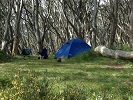
Went through my photos - only shot of the track i think i have is this one. You get the general idea...

I started at the High Lead Carpark on the main road out of Powelltown, naively thinking that the incline up the High Lead wouldn't be too bad. Made it up fine but boy, what a steep, steep, straight walk. Made every little hill that came after that seem very, very easy, so perhaps not a bad conditioner.
We camped at the Federal Mill area for the night, then did short walks to the Ada Tree the following day before winding our way back to the High Lead Carpark. We passed through the Ada No. 2 Mill campsite, and that looked like a really nice campsite - set up rather well, lots of spots. On reflection probably would have camped there instead.
That area of the track was in pretty good condition at that time - we did do it at the beginning of winter, so everything was pretty wet. Which is probably one of the better ways to see a Wet eucalypt forest...
Went through my photos - only shot of the track i think i have is this one. You get the general idea...
- fairman
- Nothofagus gunnii
- Posts: 24
- Joined: Fri 13 Feb, 2015 9:21 am
- Region: Victoria
Re: Walk into History track condition, Starling Gap to High
![]() by michael_w » Tue 19 Jul, 2016 10:56 am
by michael_w » Tue 19 Jul, 2016 10:56 am
As a group of 4 adults and 8 teenagers, we walked from Starlings Gap to Powelltown last weekend, with an overnight stop at the Ada No.2 camp site.
For the most part the track was great apart from:
- occasional boggy bits
- loads of leaf litter and twigs making the going a bit slippery in places
- plenty of fallen trees across the track that required going over or under (or possibly around)
Despite those comments, the walk was great. The High Lead descent is something else. That was the single biggest challenge for the group and we all made it, slow and steady.
It was our first time out there and the signage was good which meant the kids didn't need to navigate (which was part of our plan). Oh well.
The weather last weekend was perfect for this trip and we'll be taking other groups out there in the future for sure.
- michael_w
- Nothofagus cunninghamii

- Posts: 1
- Joined: Tue 19 Jul, 2016 10:49 am
- Region: Victoria
- Gender: Male
Re: Walk into History track condition, Starling Gap to High
![]() by JohnStrider » Mon 22 Aug, 2016 1:24 pm
by JohnStrider » Mon 22 Aug, 2016 1:24 pm
I have finally got around to putting together my report on my version of the Walk Into History.
http://www.thehikingsociety.com.au/2016 ... y-version/
As mentioned in an earlier comment on this thread, I decided to turn the trail into a circuit and was able to do this by heading north on the Ada River Road which led to a track that took me further north back to the Ada Tree Picnic area. From there I was easily able to find my way back to Big Pat's creek.
It took me two days to do it and it was about 53kms in length. There's more than enough camping spots in the area to stretch it out over 3 days maybe even 4 if you want to. Furthermore, as mentioned, just be mindful of the descent into Highlead carpark. I really don't think anything can prepare you for how steep it is. My advice is to take your time doing it and use hiking poles or a large stick to navigate your way down it. Your knees will thank you for it!
- JohnStrider
- Athrotaxis cupressoides
- Posts: 380
- Joined: Fri 12 Dec, 2014 12:34 pm
- Location: Melbourne
- Region: Victoria
- Gender: Male
27 posts
• Page 1 of 1
Who is online
Users browsing this forum: No registered users and 56 guests