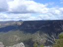
I'm thinking of a walk to Tahmoor Canyon in Potholes Reserve, starting at Rockford Bridge (on the Bargo River). It looks like a beautiful area.
Any advice from people who have been there? I have a good map.
It sounds like it's not advisable to go there soon after rain, and a recent comment (May 2020) said: "There’s quite a lot of debris after the fires so the track out of the canyon is quite hard to follow at times but there’s still some markings which get you there eventually."
Tahmoor Canyon
Forum rules
NSW & ACT specific bushwalking discussion. Please avoid publishing details of access to sensitive areas with no tracks.
NSW & ACT specific bushwalking discussion. Please avoid publishing details of access to sensitive areas with no tracks.
6 posts
• Page 1 of 1
Tahmoor Canyon
![]() by davidfisher71 » Fri 14 Aug, 2020 9:23 pm
by davidfisher71 » Fri 14 Aug, 2020 9:23 pm
- davidfisher71
- Nothofagus gunnii

- Posts: 13
- Joined: Mon 03 Jun, 2013 10:58 pm
- Region: New South Wales
- Gender: Male
Re: Tahmoor Canyon
![]() by michael_p » Sat 15 Aug, 2020 10:30 am
by michael_p » Sat 15 Aug, 2020 10:30 am
You should be alright. From memory most of the tracks are easy to follow and a fair bit of upgrade work has been done over the last few years to improve the walk. There are markers along the way to follow (see the link below for photos). Keep your eyes open and you shouldn't have too much trouble following the tracks.
The flood damage is always high along the rivers edge. I've seen debris 2-3m up trees as you walk along the Potholes Track and further down the gorge. Doing a bit of scrambling over debris has always been part of a walk around the canyon. If you are concerned about walking along the river there are alternatives. Scroll down through this report and there is a good photo of the track network: https://adventurehatblog.wordpress.com/ ... oop-track/. Doing a loop just using the higher tracks is also a nice walk.
Michael.
One foot in front of the other.
-
michael_p - Athrotaxis selaginoides

- Posts: 1377
- Joined: Sun 15 Nov, 2009 6:58 pm
- Location: Macarthur Region of Sydney.
- Region: New South Wales
- Gender: Male
Re: Tahmoor Canyon
![]() by davidfisher71 » Sat 15 Aug, 2020 11:58 am
by davidfisher71 » Sat 15 Aug, 2020 11:58 am
Awesome, thanks for that info Michael.
- davidfisher71
- Nothofagus gunnii
- Posts: 13
- Joined: Mon 03 Jun, 2013 10:58 pm
- Region: New South Wales
- Gender: Male
Re: Tahmoor Canyon
![]() by FionaShedden » Mon 17 Aug, 2020 10:03 am
by FionaShedden » Mon 17 Aug, 2020 10:03 am
Was there about a month or so back. The lock box just past mermaid pools had plenty of sketch maps. The track itself was very clear, marked beyond reasonable IMO. Was before the heavy rains last weekend, but they wouldn't have affected the painted rocks and would be surprised if they shifted the new bolted in steel foot crossing.s, they were pretty solid.
In terms of the pass back up I found it pretty easy to follow, although I did follow a fire trail along the cliffs at the top for a couple hundred meters before it dead ended. This point wasn't marked and must be the one spot that wasn't, but was just after you reached the top, and had to take a turn to your left away from the cliffs.
Was an amazing walk. Just had to ignore all the painted spots and overabundance of tape markers.
- FionaShedden
- Atherosperma moschatum

- Posts: 54
- Joined: Wed 20 Sep, 2017 9:55 pm
- Region: New South Wales
- Gender: Female
Re: Tahmoor Canyon
![]() by michael_p » Mon 17 Aug, 2020 10:19 am
by michael_p » Mon 17 Aug, 2020 10:19 am
Spoke to a friend on the weekend who lives down that way. Some of the bridges that had been installed to make the canyon part of the walk easier have been washed away in the last flood. The canyon is still passable but if you are expecting to see a bridge (as per map) and it is not there don't get too worried.
Michael.
Michael.
One foot in front of the other.
-
michael_p - Athrotaxis selaginoides
- Posts: 1377
- Joined: Sun 15 Nov, 2009 6:58 pm
- Location: Macarthur Region of Sydney.
- Region: New South Wales
- Gender: Male
Re: Tahmoor Canyon
![]() by davidfisher71 » Mon 17 Aug, 2020 8:12 pm
by davidfisher71 » Mon 17 Aug, 2020 8:12 pm
I ended up going today, but it was a bit too soon after the recent rain and the river down in the canyon was a bit too hard to cross. I had fun exploring the area though, and I ran into Robert on the way back (the guy who created the tracks and the maps) -- he was doing some chainsawing to clear the upper track. He said the water level should be down to normal in about a week.

The waterfall down into the pool was quite strong.

@FionaShedden I agree there are more than enough markers.
@michael_p Thanks again.
The waterfall down into the pool was quite strong.
@FionaShedden I agree there are more than enough markers.
@michael_p Thanks again.
- davidfisher71
- Nothofagus gunnii
- Posts: 13
- Joined: Mon 03 Jun, 2013 10:58 pm
- Region: New South Wales
- Gender: Male
6 posts
• Page 1 of 1
Return to New South Wales & ACT
Who is online
Users browsing this forum: No registered users and 1 guest