Thought I would update, I have settled on plans . I am going to go bike packing for close to three weeks. I am excited but nervous as so far have only done one single night away on my MTB.
I loved the idea of walking in KNP, so much so, that I would love to come down in Summer when the weather will mean more of the region is open to me rather than October.
Multiday walks in Kosciuszko NP
Forum rules
NSW & ACT specific bushwalking discussion. Please avoid publishing details of access to sensitive areas with no tracks.
NSW & ACT specific bushwalking discussion. Please avoid publishing details of access to sensitive areas with no tracks.
103 posts
• Page 3 of 4 • 1, 2, 3, 4
Re: Multiday walks in Kosciuszko NP
![]() by Ms_Mudd » Thu 21 May, 2020 4:33 pm
by Ms_Mudd » Thu 21 May, 2020 4:33 pm
Last edited by Ms_Mudd on Fri 22 May, 2020 9:20 pm, edited 1 time in total.
-

Ms_Mudd - Athrotaxis selaginoides

- Posts: 1032
- Joined: Fri 23 Mar, 2018 11:26 am
- Location: Tas
- Region: Tasmania
- Gender: Female
Re: Multiday walks in Kosciuszko NP
![]() by MeanderingFlyFisher » Thu 21 May, 2020 5:17 pm
by MeanderingFlyFisher » Thu 21 May, 2020 5:17 pm
Great place in Summer Ms Mudd.
Especially for what I do.
If I can be of assistance just let me know.
Especially for what I do.
If I can be of assistance just let me know.
- MeanderingFlyFisher
- Athrotaxis cupressoides

- Posts: 227
- Joined: Sun 02 Aug, 2015 7:21 pm
- Location: Warrnambool,Vic
- Region: Victoria
- Gender: Male
Re: Multiday walks in Kosciuszko NP
![]() by Ms_Mudd » Fri 22 May, 2020 7:52 pm
by Ms_Mudd » Fri 22 May, 2020 7:52 pm
Thanks MFF! I am so keen to sling my pack on and do some meandering of my own, such a special place you lot have down there.
My bikepacking adventure will actually finish up down your way too, so if weather permits, I might manage a day walk if my legs are still functioning from weeks of pedaling
My bikepacking adventure will actually finish up down your way too, so if weather permits, I might manage a day walk if my legs are still functioning from weeks of pedaling
-
Ms_Mudd - Athrotaxis selaginoides
- Posts: 1032
- Joined: Fri 23 Mar, 2018 11:26 am
- Location: Tas
- Region: Tasmania
- Gender: Female
Re: Multiday walks in Kosciuszko NP
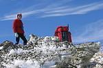
![]() by rcaffin » Sat 23 May, 2020 6:28 pm
by rcaffin » Sat 23 May, 2020 6:28 pm
October: I have seen good snow cover then in some places.
Oh well, really fat tires with chains?
Summit of Mt Jagungal, taken in late September.
You WILL need full winter gear for safety.
Cheers
Roger
Oh well, really fat tires with chains?
- 5856.jpg (95.63 KiB) Viewed 31019 times
Summit of Mt Jagungal, taken in late September.
You WILL need full winter gear for safety.
Cheers
Roger
-
rcaffin - Athrotaxis selaginoides
- Posts: 1296
- Joined: Thu 17 Jul, 2008 3:46 pm
Re: Multiday walks in Kosciuszko NP
![]() by Ms_Mudd » Sat 23 May, 2020 7:53 pm
by Ms_Mudd » Sat 23 May, 2020 7:53 pm
Gorgeous photo Roger, spectacular!
I am not riding down that way on the Oct trip, but will end up down there with my husband for a few days of relaxing 'Alpiney' holiday after he collects me from that ride Can't wait to do some walking in KNP and Namadgi in Summer though.
I am not riding down that way on the Oct trip, but will end up down there with my husband for a few days of relaxing 'Alpiney' holiday after he collects me from that ride
-
Ms_Mudd - Athrotaxis selaginoides
- Posts: 1032
- Joined: Fri 23 Mar, 2018 11:26 am
- Location: Tas
- Region: Tasmania
- Gender: Female
Re: Multiday walks in Kosciuszko NP
![]() by north-north-west » Sat 23 May, 2020 8:11 pm
by north-north-west » Sat 23 May, 2020 8:11 pm
*sigh*
I miss the Big Jagged Pill.
I miss the Big Jagged Pill.
"Mit der Dummheit kämpfen Götter selbst vergebens."
-

north-north-west - Lagarostrobos franklinii

- Posts: 15405
- Joined: Thu 14 May, 2009 7:36 pm
- Location: The Asylum
- ASSOCIATED ORGANISATIONS: Social Misfits Anonymous
- Region: Tasmania
Re: Multiday walks in Kosciuszko NP
![]() by NickH » Sun 07 Jun, 2020 9:53 pm
by NickH » Sun 07 Jun, 2020 9:53 pm
Righto!!!!!
I've had enough! I can read no further! With all this Iso stuff and too much time to do interwebs...... I'm going. GOING I tells ya!!!
Tonight is Sunday of the June LWE. By friday morn, I'll be as far up the SP fire trail as permits.. (I expect to be at the gate as I'm as stubborn as the diesel I'll be driving).
I wanted to go solo, but my liddl brudda from the 'Berra has asked if he can come too and I can't say no (sigh).
Plans are loose, but I want to track GH's track along the Great Divide as closely as I can. A night at the Tarn, and a reccy for a winter ascent of J from Cesjacks and an additional reccy of the way down to Kidmans from Mawsons. If the weather is crook, we'll base camp at Cesjacks
I'm new at this. Tips are welcome! Thanks for the inspo)
I've had enough! I can read no further! With all this Iso stuff and too much time to do interwebs...... I'm going. GOING I tells ya!!!
Tonight is Sunday of the June LWE. By friday morn, I'll be as far up the SP fire trail as permits.. (I expect to be at the gate as I'm as stubborn as the diesel I'll be driving).
I wanted to go solo, but my liddl brudda from the 'Berra has asked if he can come too and I can't say no (sigh).
Plans are loose, but I want to track GH's track along the Great Divide as closely as I can. A night at the Tarn, and a reccy for a winter ascent of J from Cesjacks and an additional reccy of the way down to Kidmans from Mawsons. If the weather is crook, we'll base camp at Cesjacks
I'm new at this. Tips are welcome! Thanks for the inspo
- NickH
- Nothofagus gunnii

- Posts: 30
- Joined: Thu 07 Feb, 2019 12:56 pm
- Location: Newcastle NSW
- Region: New South Wales
- Gender: Male
Re: Multiday walks in Kosciuszko NP
![]() by Zapruda » Sun 07 Jun, 2020 10:00 pm
by Zapruda » Sun 07 Jun, 2020 10:00 pm
Have fun Nick. I just got home from a 7 day trip up there. Lots of snow fell on Monday and there was quite a bit left yesterday.
View from Big Bogong on Tuesday Morning. Bliss!
View from Big Bogong on Tuesday Morning. Bliss!
- Attachments
-
-
-

Zapruda - Athrotaxis selaginoides
- Posts: 1682
- Joined: Thu 07 Apr, 2016 10:46 am
- Region: Australian Capital Territory
- Gender: Male
Re: Multiday walks in Kosciuszko NP
![]() by NickH » Sun 07 Jun, 2020 10:07 pm
by NickH » Sun 07 Jun, 2020 10:07 pm
Whoa!! I was not expecting that much snow!
The Scarpas may be tested!
Plans may be revised...
The Scarpas may be tested!
Plans may be revised...
- NickH
- Nothofagus gunnii
- Posts: 30
- Joined: Thu 07 Feb, 2019 12:56 pm
- Location: Newcastle NSW
- Region: New South Wales
- Gender: Male
Re: Multiday walks in Kosciuszko NP
![]() by Zapruda » Sun 07 Jun, 2020 10:18 pm
by Zapruda » Sun 07 Jun, 2020 10:18 pm
NickH wrote:Whoa!! I was not expecting that much snow!
The Scarpas may be tested!
Plans may be revised...
I used runners, boots be damned
Snow melts quickly. There will be plenty of snow left on Jagungal and on the other peaks, especially on the south eastern aspects . The valleys may be snow free by now. It’s always a guessing game early on in the season. It’s certainly not snowshoe or ski conditions yet but my tolerance for postholing may be different to others.
If you find it too snowy head over to Pretty Plain or spend some time around Far Bald and surrounds but I’m confident it will be alright. You can easily get to areas north of Jagungal from Cesjacks.
-
Zapruda - Athrotaxis selaginoides
- Posts: 1682
- Joined: Thu 07 Apr, 2016 10:46 am
- Region: Australian Capital Territory
- Gender: Male
Re: Multiday walks in Kosciuszko NP
![]() by NickH » Sun 07 Jun, 2020 10:28 pm
by NickH » Sun 07 Jun, 2020 10:28 pm
I was thinking something a little bit more Julie Andrews..... Where's the *&%$#! grass??
- NickH
- Nothofagus gunnii
- Posts: 30
- Joined: Thu 07 Feb, 2019 12:56 pm
- Location: Newcastle NSW
- Region: New South Wales
- Gender: Male
Re: Multiday walks in Kosciuszko NP
![]() by Ms_Mudd » Mon 08 Jun, 2020 4:08 pm
by Ms_Mudd » Mon 08 Jun, 2020 4:08 pm
Amazing images! Looks like a good time had.
-
Ms_Mudd - Athrotaxis selaginoides
- Posts: 1032
- Joined: Fri 23 Mar, 2018 11:26 am
- Location: Tas
- Region: Tasmania
- Gender: Female
Re: Multiday walks in Kosciuszko NP
![]() by NickH » Mon 08 Jun, 2020 5:41 pm
by NickH » Mon 08 Jun, 2020 5:41 pm
Was planning to camp at the tarn,as I've never seen it before. Then explore pathways to Kidmans. I think we may head straight to Mawsons instead.
Zapruda, did you use the snowy Plains FT? How was it?
Zapruda, did you use the snowy Plains FT? How was it?
- NickH
- Nothofagus gunnii
- Posts: 30
- Joined: Thu 07 Feb, 2019 12:56 pm
- Location: Newcastle NSW
- Region: New South Wales
- Gender: Male
Re: Multiday walks in Kosciuszko NP
![]() by Zapruda » Mon 08 Jun, 2020 6:04 pm
by Zapruda » Mon 08 Jun, 2020 6:04 pm
NickH wrote:Was planning to camp at the tarn,as I've never seen it before. Then explore pathways to Kidmans. I think we may head straight to Mawsons instead.
Zapruda, did you use the snowy Plains FT? How was it?
No, I parked at Euc cove and went in via HJ road. I have it on good authority that the snowy plains FT is well graded atm because of the fires.
Definitely camp at the Tarn. So nice.
-
Zapruda - Athrotaxis selaginoides
- Posts: 1682
- Joined: Thu 07 Apr, 2016 10:46 am
- Region: Australian Capital Territory
- Gender: Male
Re: Multiday walks in Kosciuszko NP
![]() by NickH » Mon 08 Jun, 2020 7:14 pm
by NickH » Mon 08 Jun, 2020 7:14 pm
There's a relatively new hut tucked away in a corner on private land, just near Spencers Peak. I'm rather jealous!
- NickH
- Nothofagus gunnii
- Posts: 30
- Joined: Thu 07 Feb, 2019 12:56 pm
- Location: Newcastle NSW
- Region: New South Wales
- Gender: Male
Re: Multiday walks in Kosciuszko NP
![]() by NickH » Tue 09 Jun, 2020 1:55 pm
by NickH » Tue 09 Jun, 2020 1:55 pm
Zapruda wrote:Ms_Mudd wrote:Thanks, I am not being lazy, just short on any knowledge for Namadgi and KNP and not entirely where to start with such a trip yet.
I read over some trip reports across the weekend that I found online, so the research has started. I really value local, experienced intel and am so grateful for this forum. I have found in the past, hints and tips from forum users have ended up being super valuable to me on my adventures.
I may or may not have my own car, whichever works out best/ I would possibly leave it for my husband to drive to meet me or alternatively take it myself if it makes logistics easier and the fam can catch the Countrylink train down to Canberra for me to pick them up.
Thats the beauty of this forum Ms Mudd, there are lots of knowledgable people here and they are more than happy to share that knowledge, especially in times of isolation
http://maps.ozultimate.com/?lat=-35.761 ... 8713466792
I thought this route up last night. It is a very rough idea and it shouldn't be taken as gospel. If you are keen we can develop it further.
It is about 230km long and It takes in all the AAWT in the ACT and most of it north of Kiandra in NSW. The route is mostly on management trails and there is only one bit of non AAWT off track walking but it is easy and pleasant. Id expect that this would take someone anywhere between 8 and 12 leisurely days. Carrying that much food can be a pain but I have some ideas for that.
Keep in mind that this all depends on Namadgi re-opening. It is still closed because of fire damage. There has been no word on when it will re-open again...
You start and finish at the Namadgi visitor centre near Tharwa. A car can be left here free of charge.
It takes in many beautiful huts and areas. Most notably Blue Waterholes and the gorges, Nungar Plain, Baroomba Rocks and Mt Bimberi. You will see lots of Feral horses and a good assortment of birdlife. Water is abundant for most of the walk.
Some of the dangers mostly revolve around poor weather, including snow, low temperatures ( I recorded -9c on Tantangara Plain one September morning...) and high river crossings. I have given rough alternates for the dangerous river crossings if they are high. I can provide more detail on the alternates if we get to that stage.
Have a gander and ask any questions that pop in to your head. If it doesn't appeal to you I completely understand, It might not be for everyone
I also had another thought last night. The Hume and Hovel walking track from Yass to Albury could be an option. I have never walked it but I have heard good things. September might be the perfect time to walk it as well.
https://www.humeandhovelltrack.com.au/
That loop looks like just the thing for me in Spring Zapruda! I'm going to have a closer look at that after this quick w/e sprint to Mawsons. I had it in mind to get to the Cascades but the Currango area is something very close to my heart. At the age of 12weeks I was 'abandoned' by my parents and left in a basket on the table in Currango, with a note reading; "Gone to QLD droving, please look after the baby"
Story goes, Molly Taylor just about lifted the roof off and had old Tom running across the paddock to see what the commotion was! My parents were giggling themselves silly in the spare room
- NickH
- Nothofagus gunnii
- Posts: 30
- Joined: Thu 07 Feb, 2019 12:56 pm
- Location: Newcastle NSW
- Region: New South Wales
- Gender: Male
Re: Multiday walks in Kosciuszko NP
![]() by Zapruda » Tue 09 Jun, 2020 2:08 pm
by Zapruda » Tue 09 Jun, 2020 2:08 pm
Haha, I love that story Nick. I am very glad Currango was spared in the fires. So much history there.
The Northern end of KNP often gets forgotten about by a lot of bushwalkers. I'm not sure why. Maybe the allure of higher peaks draws them further south. I personally love it. The terrain and weather are a bit more forgiving and there is an abundance of route options, huts and historical sites. The views toward the rugged peaks on the NSW/ACT border are also beautiful from there.
The Cascades are also a beautiful part of the park. The plateau south of Thredbo up around the Drift Hill area is just spectacular.
Report back with how the walk to Mawson's went.
-
Zapruda - Athrotaxis selaginoides
- Posts: 1682
- Joined: Thu 07 Apr, 2016 10:46 am
- Region: Australian Capital Territory
- Gender: Male
Re: Multiday walks in Kosciuszko NP
![]() by north-north-west » Wed 10 Jun, 2020 8:02 am
by north-north-west » Wed 10 Jun, 2020 8:02 am
Zapruda wrote:The Cascades are also a beautiful part of the park. The plateau south of Thredbo up around the Drift Hill area is just spectacular.
Brindle Bull, Paddy Rushs, Leo, Drift, Terrible, Chimneys. Just so beautiful under snow, especially camping on the saddle up above Teds, with all the pools iced over . . .
You guys are making me so nostalgic for the mainland.
"Mit der Dummheit kämpfen Götter selbst vergebens."
-
north-north-west - Lagarostrobos franklinii
- Posts: 15405
- Joined: Thu 14 May, 2009 7:36 pm
- Location: The Asylum
- ASSOCIATED ORGANISATIONS: Social Misfits Anonymous
- Region: Tasmania
Re: Multiday walks in Kosciuszko NP
![]() by rcaffin » Wed 10 Jun, 2020 3:34 pm
by rcaffin » Wed 10 Jun, 2020 3:34 pm
Dawn on the Upper Geehi, with flash.
Flash under-powered, but still.
Cheers
Roger
- DawnGeehiS.jpg (66.19 KiB) Viewed 30485 times
Flash under-powered, but still.
Cheers
Roger
-
rcaffin - Athrotaxis selaginoides
- Posts: 1296
- Joined: Thu 17 Jul, 2008 3:46 pm
Re: Multiday walks in Kosciuszko NP
![]() by NickH » Wed 10 Jun, 2020 7:25 pm
by NickH » Wed 10 Jun, 2020 7:25 pm
Thats my plan!! I missed out last winter. Thanks Roger, very motivating
- NickH
- Nothofagus gunnii
- Posts: 30
- Joined: Thu 07 Feb, 2019 12:56 pm
- Location: Newcastle NSW
- Region: New South Wales
- Gender: Male
Re: Multiday walks in Kosciuszko NP
![]() by rcaffin » Wed 10 Jun, 2020 7:44 pm
by rcaffin » Wed 10 Jun, 2020 7:44 pm
Somewhere near 4-ways:
Strawberries Hills, somewhere:
Above Bluff Tarn before the weather changed:
Motivate, motivate, motivate ...
Cheers
Roger
- 0821.jpg (80.18 KiB) Viewed 30475 times
Strawberries Hills, somewhere:
- 0788.jpg (93.88 KiB) Viewed 30475 times
Above Bluff Tarn before the weather changed:
- 5818S.jpg (95.75 KiB) Viewed 30475 times
Motivate, motivate, motivate ...
Cheers
Roger
-
rcaffin - Athrotaxis selaginoides
- Posts: 1296
- Joined: Thu 17 Jul, 2008 3:46 pm
Re: Multiday walks in Kosciuszko NP
![]() by NickH » Wed 10 Jun, 2020 9:07 pm
by NickH » Wed 10 Jun, 2020 9:07 pm
I'm torn between duck ills and ntn...
These old knees... Dunno if I could drag a knee these days. Or even if I want to re-learn
Putting turns in on AT gear, could do though.
But they don't seem to be efficient on the flats?
These old knees... Dunno if I could drag a knee these days. Or even if I want to re-learn
Putting turns in on AT gear, could do though.
But they don't seem to be efficient on the flats?
- NickH
- Nothofagus gunnii
- Posts: 30
- Joined: Thu 07 Feb, 2019 12:56 pm
- Location: Newcastle NSW
- Region: New South Wales
- Gender: Male
Re: Multiday walks in Kosciuszko NP
![]() by Zapruda » Wed 10 Jun, 2020 9:16 pm
by Zapruda » Wed 10 Jun, 2020 9:16 pm
NickH wrote:I'm torn between duck ills and ntn...
These old knees... Dunno if I could drag a knee these days. Or even if I want to re-learn
Putting turns in on AT gear, could do though.
But they don't seem to be efficient on the flats?
I went from years of 75mm and also NNNBC to really light tech bindings and kept the skinny skis and light boots. Best decision ever. Lighter, quicker and my sloppy Tele turns are a thing of the past
I ski for distance and touring not for turns but it’s really nice to setup the tent after a long day and have some fun down the hills.
-
Zapruda - Athrotaxis selaginoides
- Posts: 1682
- Joined: Thu 07 Apr, 2016 10:46 am
- Region: Australian Capital Territory
- Gender: Male
Re: Multiday walks in Kosciuszko NP
![]() by NickH » Wed 10 Jun, 2020 10:30 pm
by NickH » Wed 10 Jun, 2020 10:30 pm
OK! I'm interested! I'm pragmatic. Everyone likes to descend with some panache, but Aus is, well, flat. It's just flat! One season in the Northern Hemisphere is enough. Ok, there's steep bits. Like the lodge driveways at Thredbo. But you get the idea. Most of the time is spent going 'along'. Neither up, nor down, but along.
I want to move along efficiently and descend the steepest icy line there is, and re-live my GS days!
What do I get?
I want to move along efficiently and descend the steepest icy line there is, and re-live my GS days!
What do I get?
- NickH
- Nothofagus gunnii
- Posts: 30
- Joined: Thu 07 Feb, 2019 12:56 pm
- Location: Newcastle NSW
- Region: New South Wales
- Gender: Male
Re: Multiday walks in Kosciuszko NP
![]() by rcaffin » Thu 11 Jun, 2020 8:14 am
by rcaffin » Thu 11 Jun, 2020 8:14 am
The narrower the skis and the less the waist, the faster the skis.
The less the waist, the harder it is to turn though. (Can be done.)
What size boot do you need?
Cheers
Roger
The less the waist, the harder it is to turn though. (Can be done.)
What size boot do you need?
Cheers
Roger
-
rcaffin - Athrotaxis selaginoides
- Posts: 1296
- Joined: Thu 17 Jul, 2008 3:46 pm
Re: Multiday walks in Kosciuszko NP
![]() by Zapruda » Thu 11 Jun, 2020 8:23 am
by Zapruda » Thu 11 Jun, 2020 8:23 am
NickH wrote:OK! I'm interested! I'm pragmatic. Everyone likes to descend with some panache, but Aus is, well, flat. It's just flat! One season in the Northern Hemisphere is enough. Ok, there's steep bits. Like the lodge driveways at Thredbo. But you get the idea. Most of the time is spent going 'along'. Neither up, nor down, but along.
I want to move along efficiently and descend the steepest icy line there is, and re-live my GS days!
What do I get?
Last season I was very happy with my new Madshus Epochs. They are 68 underfoot with a small curve and pattern base. I had no trouble getting to Mt Jagungal from Munyang and back to Tin in a day last year. Very speedy and while not the best carvers out there I could still manage a few turns.
As Roger has said. Skinny for speedy, fatter for turns. Most diehards believe in a quiver of skis... but if the goal is to essentially bushwalk with skis then skinny would be my choice.
-
Zapruda - Athrotaxis selaginoides
- Posts: 1682
- Joined: Thu 07 Apr, 2016 10:46 am
- Region: Australian Capital Territory
- Gender: Male
Re: Multiday walks in Kosciuszko NP
![]() by crollsurf » Fri 18 Sep, 2020 10:47 am
by crollsurf » Fri 18 Sep, 2020 10:47 am
Just been talking to Parks about what will be open after the October long weekend and thought others may be interest. This map is a guide to what will be open after the October long weekend. Basically anything in Red will remain closed for the time being. https://www.nationalparks.nsw.gov.au/-/media/visitor/files/pdf/maps/kosciuszko-back-country-closures-map-sept-2020.pdf
Roads from Kiandra to Khancoban will remain closed. Tooma Road is not expected to open until May 2021 (in reality, I'm guessing not until after Winter in October 2021)
Long Plain Road to Broken Cart and Blue Waterhole are expected to open to cars. Port Phillip Tr is also expected to open to cars as well.
They have been waiting until after the snow and blizzards have knocked down any damaged trees before accessing tree safety along tracks in the Red zones. I believe work has already started in the Red zone south of Kiandra.
-

crollsurf - Lagarostrobos franklinii
- Posts: 2316
- Joined: Tue 07 Mar, 2017 10:07 am
- Location: Sydney
- Region: New South Wales
- Gender: Male
Re: Multiday walks in Kosciuszko NP
![]() by rcaffin » Fri 18 Sep, 2020 11:03 am
by rcaffin » Fri 18 Sep, 2020 11:03 am
They have been waiting until after the snow and blizzards have knocked down any damaged trees before accessing tree safety along tracks in the Red zones.
We are still struggling in many places with dead trees from 2003.
Sigh
Cheers
Roger
We are still struggling in many places with dead trees from 2003.
Sigh
Cheers
Roger
-
rcaffin - Athrotaxis selaginoides
- Posts: 1296
- Joined: Thu 17 Jul, 2008 3:46 pm
Re: Multiday walks in Kosciuszko NP
![]() by Lophophaps » Sat 19 Sep, 2020 7:21 am
by Lophophaps » Sat 19 Sep, 2020 7:21 am
Can anyone advise where the Cabramurra Road gate at the Khancoban end is located? If it's north of the Bradneys Gap picnic area then access west to Pretty Plan and Grey Mare Hut is possible. If enough people do this the 4WD track over the Strumbo Range may be easier. Guthega Power Station will probably be the main access to Jagungal for much of the next year.
-
Lophophaps - Auctorita modica

- Posts: 3467
- Joined: Wed 09 Nov, 2011 9:45 am
- Region: Victoria
- Gender: Male
Re: Multiday walks in Kosciuszko NP
![]() by rcaffin » Sat 19 Sep, 2020 8:38 am
by rcaffin » Sat 19 Sep, 2020 8:38 am
Can anyone advise where the Cabramurra Road gate at the Khancoban end is located? If it's north of the Bradneys Gap picnic area then access west to Pretty Plan and Grey Mare Hut is possible. If enough people do this the 4WD track over the Strumbo Range may be easier. Guthega Power Station will probably be the main access to Jagungal for much of the next year.
Have a look at the NPWS map posted above. Seems to me that the entire Cabramurra Rd is closed.
I think Guthega has always been the main entry point for Jagungal, at least for casual walkers. Hence the car parks there.
Cheers
Roger
-
rcaffin - Athrotaxis selaginoides
- Posts: 1296
- Joined: Thu 17 Jul, 2008 3:46 pm
103 posts
• Page 3 of 4 • 1, 2, 3, 4
Return to New South Wales & ACT
Who is online
Users browsing this forum: No registered users and 6 guests