Game: Where-is-it (Aussie)
Only administrators may post new topics to this forum. Registered users can post replies.
Re: Game: Where-is-it (Aussie)
![]() by Walk_fat boy_walk » Fri 04 Feb, 2022 10:20 am
by Walk_fat boy_walk » Fri 04 Feb, 2022 10:20 am
- Walk_fat boy_walk
- Lagarostrobos franklinii

- Posts: 2097
- Joined: Sat 21 Nov, 2009 6:59 am
- Gender: Male
Re: Game: Where-is-it (Aussie)
![]() by johnw » Fri 04 Feb, 2022 12:16 pm
by johnw » Fri 04 Feb, 2022 12:16 pm
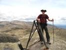
Walk_fat boy_walk wrote:Main range track above Blue Lake? Approaching the saddle between Carruthers and Twynam?
Yep, spot on. On my way up to Twynam via the standard route. That, often present, summer drift is an extra clue for those who know it.
In Nature's keeping they are safe, but through the agency of man destruction is making rapid progress - John Muir c1912
-
johnw - Lagarostrobos franklinii
- Posts: 9053
- Joined: Wed 23 Jan, 2008 11:59 am
- Location: Macarthur Region - SW Sydney
- Region: New South Wales
- Gender: Male
Re: Game: Where-is-it (Aussie)
![]() by Walk_fat boy_walk » Fri 04 Feb, 2022 2:36 pm
by Walk_fat boy_walk » Fri 04 Feb, 2022 2:36 pm
- Attachments
-
- Walk_fat boy_walk
- Lagarostrobos franklinii
- Posts: 2097
- Joined: Sat 21 Nov, 2009 6:59 am
- Gender: Male
Re: Game: Where-is-it (Aussie)
![]() by johnw » Fri 04 Feb, 2022 3:14 pm
by johnw » Fri 04 Feb, 2022 3:14 pm
Snowy River backed by the Twynams.
In Nature's keeping they are safe, but through the agency of man destruction is making rapid progress - John Muir c1912
-
johnw - Lagarostrobos franklinii
- Posts: 9053
- Joined: Wed 23 Jan, 2008 11:59 am
- Location: Macarthur Region - SW Sydney
- Region: New South Wales
- Gender: Male
Re: Game: Where-is-it (Aussie)
![]() by Walk_fat boy_walk » Fri 04 Feb, 2022 8:40 pm
by Walk_fat boy_walk » Fri 04 Feb, 2022 8:40 pm
Yes the pre-existing section, between Guthega and Illawongjohnw wrote:Are you on that new Guthega-CP track that I walked the other week, or at least the (pre-existing) Illawong section of it?
Snowy River backed by the Twynams.
Sent from my SM-G977B using Tapatalk
- Walk_fat boy_walk
- Lagarostrobos franklinii
- Posts: 2097
- Joined: Sat 21 Nov, 2009 6:59 am
- Gender: Male
Re: Game: Where-is-it (Aussie)
![]() by johnw » Fri 04 Feb, 2022 9:30 pm
by johnw » Fri 04 Feb, 2022 9:30 pm
ACT:
- Approaching the trig on Mt Boboyan/Yerrabi track, Namadgi NP via Tharwa ACT
In Nature's keeping they are safe, but through the agency of man destruction is making rapid progress - John Muir c1912
-
johnw - Lagarostrobos franklinii
- Posts: 9053
- Joined: Wed 23 Jan, 2008 11:59 am
- Location: Macarthur Region - SW Sydney
- Region: New South Wales
- Gender: Male
Re: Game: Where-is-it (Aussie)
![]() by sandym » Sat 05 Feb, 2022 1:32 pm
by sandym » Sat 05 Feb, 2022 1:32 pm
Mount Franklin?
- sandym
- Phyllocladus aspleniifolius

- Posts: 516
- Joined: Wed 19 Sep, 2012 7:34 pm
- Region: New South Wales
- Gender: Female
Re: Game: Where-is-it (Aussie)
![]() by Walk_fat boy_walk » Sat 05 Feb, 2022 3:08 pm
by Walk_fat boy_walk » Sat 05 Feb, 2022 3:08 pm
Sent from my SM-G977B using Tapatalk
- Walk_fat boy_walk
- Lagarostrobos franklinii
- Posts: 2097
- Joined: Sat 21 Nov, 2009 6:59 am
- Gender: Male
Re: Game: Where-is-it (Aussie)
![]() by johnw » Sat 05 Feb, 2022 4:07 pm
by johnw » Sat 05 Feb, 2022 4:07 pm
Walk_fat boy_walk wrote:Yerrabi?
Yes, approaching Mt Boboyan trig on the Yerrabi track in Namadgi NP. Lot of variety for such a short walk.
In Nature's keeping they are safe, but through the agency of man destruction is making rapid progress - John Muir c1912
-
johnw - Lagarostrobos franklinii
- Posts: 9053
- Joined: Wed 23 Jan, 2008 11:59 am
- Location: Macarthur Region - SW Sydney
- Region: New South Wales
- Gender: Male
Re: Game: Where-is-it (Aussie)
![]() by Walk_fat boy_walk » Sat 05 Feb, 2022 6:11 pm
by Walk_fat boy_walk » Sat 05 Feb, 2022 6:11 pm
Sent from my SM-G977B using Tapatalk
- Walk_fat boy_walk
- Lagarostrobos franklinii
- Posts: 2097
- Joined: Sat 21 Nov, 2009 6:59 am
- Gender: Male
Re: Game: Where-is-it (Aussie)
![]() by GregG » Sat 05 Feb, 2022 10:56 pm
by GregG » Sat 05 Feb, 2022 10:56 pm
- Attachments
-
- GregG
- Phyllocladus aspleniifolius
- Posts: 691
- Joined: Sat 09 Nov, 2019 6:44 pm
- ASSOCIATED ORGANISATIONS: Old bushie
- Region: New South Wales
- Gender: Male
Re: Game: Where-is-it (Aussie)
![]() by johnw » Sun 06 Feb, 2022 12:32 pm
by johnw » Sun 06 Feb, 2022 12:32 pm
It looks BMs and I'd assume near the railway line from the clue, suggesting maybe a railway dam from the steam era.
The only thing that comes to mind is the Clarence/Dargan Creek dam, although I admit I haven't been there and it doesn't match the photos I've seen.
In Nature's keeping they are safe, but through the agency of man destruction is making rapid progress - John Muir c1912
-
johnw - Lagarostrobos franklinii
- Posts: 9053
- Joined: Wed 23 Jan, 2008 11:59 am
- Location: Macarthur Region - SW Sydney
- Region: New South Wales
- Gender: Male
Re: Game: Where-is-it (Aussie)
![]() by GregG » Sun 06 Feb, 2022 1:06 pm
by GregG » Sun 06 Feb, 2022 1:06 pm
johnw wrote:It looks BMs and I'd assume near the railway line from the clue, suggesting maybe a railway dam from the steam era.
The only thing that comes to mind is the Clarence/Dargan Creek dam, although I admit I haven't been there and it doesn't match the photos I've seen.
Those are all good assumptions John except that if you were at Clarence you must have nodded off and missed your stop by about forty minutes or so ( easy to do I know from long experience
- Attachments
-
- GregG
- Phyllocladus aspleniifolius
- Posts: 691
- Joined: Sat 09 Nov, 2019 6:44 pm
- ASSOCIATED ORGANISATIONS: Old bushie
- Region: New South Wales
- Gender: Male
Re: Game: Where-is-it (Aussie)
![]() by johnw » Sun 06 Feb, 2022 2:11 pm
by johnw » Sun 06 Feb, 2022 2:11 pm
GregG wrote:Those are all good assumptions John except that if you were at Clarence you must have nodded off and missed your stop by about forty minutes or so ( easy to do I know from long experience) While I was on my way to the structure, floundering around fighting a closed matched battle with b#@$%&d scrub, I came across this sign:
Ahem, yes did happen occasionally when I was working
I've walked Sassafras, Wiggins, Victory tracks et al many times but can't recall this small dam. I did have a look through my Bruce Cameron book to no avail, but it's a big book.
If you were off track could be a side creek? In which case I should make time to find it myself.
In Nature's keeping they are safe, but through the agency of man destruction is making rapid progress - John Muir c1912
-
johnw - Lagarostrobos franklinii
- Posts: 9053
- Joined: Wed 23 Jan, 2008 11:59 am
- Location: Macarthur Region - SW Sydney
- Region: New South Wales
- Gender: Male
Re: Game: Where-is-it (Aussie)
![]() by jonnosan » Sun 06 Feb, 2022 3:06 pm
by jonnosan » Sun 06 Feb, 2022 3:06 pm
-

jonnosan - Phyllocladus aspleniifolius
- Posts: 896
- Joined: Fri 27 Jan, 2012 4:06 pm
- Region: New South Wales
- Gender: Male
Re: Game: Where-is-it (Aussie)
![]() by jonnosan » Sun 06 Feb, 2022 3:14 pm
by jonnosan » Sun 06 Feb, 2022 3:14 pm
Seems to be a weir that was (probably) used for supplying water to steam trains? Am intrigued now - will have to check it out (I guess I better do it on a Monday or Tuesday!)
-
jonnosan - Phyllocladus aspleniifolius
- Posts: 896
- Joined: Fri 27 Jan, 2012 4:06 pm
- Region: New South Wales
- Gender: Male
Re: Game: Where-is-it (Aussie)
![]() by johnw » Sun 06 Feb, 2022 4:47 pm
by johnw » Sun 06 Feb, 2022 4:47 pm
jonnosan wrote:Seems to be a weir that was (probably) used for supplying water to steam trains? Am intrigued now
Me too. Maybe not for steam trains after all, could be this one?
https://trove.nla.gov.au/newspaper/article/16470948
In Nature's keeping they are safe, but through the agency of man destruction is making rapid progress - John Muir c1912
-
johnw - Lagarostrobos franklinii
- Posts: 9053
- Joined: Wed 23 Jan, 2008 11:59 am
- Location: Macarthur Region - SW Sydney
- Region: New South Wales
- Gender: Male
Re: Game: Where-is-it (Aussie)
![]() by GregG » Sun 06 Feb, 2022 9:02 pm
by GregG » Sun 06 Feb, 2022 9:02 pm
Over to you Jonnosan
- Attachments
-
- GregG
- Phyllocladus aspleniifolius
- Posts: 691
- Joined: Sat 09 Nov, 2019 6:44 pm
- ASSOCIATED ORGANISATIONS: Old bushie
- Region: New South Wales
- Gender: Male
Re: Game: Where-is-it (Aussie)
![]() by puredingo » Mon 07 Feb, 2022 7:24 am
by puredingo » Mon 07 Feb, 2022 7:24 am
- puredingo
- Athrotaxis selaginoides

- Posts: 1270
- Joined: Mon 13 Feb, 2012 6:54 am
- Region: New South Wales
Re: Game: Where-is-it (Aussie)
![]() by jonnosan » Mon 07 Feb, 2022 8:06 am
by jonnosan » Mon 07 Feb, 2022 8:06 am
- Attachments
-
-
jonnosan - Phyllocladus aspleniifolius
- Posts: 896
- Joined: Fri 27 Jan, 2012 4:06 pm
- Region: New South Wales
- Gender: Male
Re: Game: Where-is-it (Aussie)
![]() by GregG » Mon 07 Feb, 2022 9:13 am
by GregG » Mon 07 Feb, 2022 9:13 am
puredingo wrote:That corrugated iron is in remarkably good condition for its age!?
That is true puredingo. Although the hardwood frame is starting to rot out the iron sheeting is in remarkably good condition considering that it has a lot of rotting vegetation and soil piled up against it in many places. It must have also somehow survived the various fires that have gone through there over the years which is surprising considering the amount of very dense scrub that surrounds it now. I dont know how long ago it fell into disuse, a fair while by the look of things.
- GregG
- Phyllocladus aspleniifolius
- Posts: 691
- Joined: Sat 09 Nov, 2019 6:44 pm
- ASSOCIATED ORGANISATIONS: Old bushie
- Region: New South Wales
- Gender: Male
Re: Game: Where-is-it (Aussie)
![]() by GregG » Mon 07 Feb, 2022 9:17 am
by GregG » Mon 07 Feb, 2022 9:17 am
- GregG
- Phyllocladus aspleniifolius
- Posts: 691
- Joined: Sat 09 Nov, 2019 6:44 pm
- ASSOCIATED ORGANISATIONS: Old bushie
- Region: New South Wales
- Gender: Male
Re: Game: Where-is-it (Aussie)
![]() by jonnosan » Mon 07 Feb, 2022 10:00 am
by jonnosan » Mon 07 Feb, 2022 10:00 am
-
jonnosan - Phyllocladus aspleniifolius
- Posts: 896
- Joined: Fri 27 Jan, 2012 4:06 pm
- Region: New South Wales
- Gender: Male
Re: Game: Where-is-it (Aussie)
![]() by jonnosan » Mon 07 Feb, 2022 5:00 pm
by jonnosan » Mon 07 Feb, 2022 5:00 pm
-
jonnosan - Phyllocladus aspleniifolius
- Posts: 896
- Joined: Fri 27 Jan, 2012 4:06 pm
- Region: New South Wales
- Gender: Male
Re: Game: Where-is-it (Aussie)
![]() by johnw » Mon 07 Feb, 2022 10:38 pm
by johnw » Mon 07 Feb, 2022 10:38 pm
jonnosan wrote:Not Kings Cave - this is on the opposite side of the GWH.
jonnosan wrote:Probably about a half hour drive from Kings Cave also.
Puts you around Blackheath, southern side. Many years since I was there, maybe Mermaids Cave?
In Nature's keeping they are safe, but through the agency of man destruction is making rapid progress - John Muir c1912
-
johnw - Lagarostrobos franklinii
- Posts: 9053
- Joined: Wed 23 Jan, 2008 11:59 am
- Location: Macarthur Region - SW Sydney
- Region: New South Wales
- Gender: Male
Re: Game: Where-is-it (Aussie)
![]() by jonnosan » Tue 08 Feb, 2022 6:22 am
by jonnosan » Tue 08 Feb, 2022 6:22 am
johnw wrote:Puts you around Blackheath, southern side. Many years since I was there, maybe Mermaids Cave?
You must drive a little faster than I do. Not Mermaids cave.
This cave has a pretty unimaginative name, and is at the same level as the bottom member of a more creatively named pair of caves that are nearby.
-
jonnosan - Phyllocladus aspleniifolius
- Posts: 896
- Joined: Fri 27 Jan, 2012 4:06 pm
- Region: New South Wales
- Gender: Male
Re: Game: Where-is-it (Aussie)
![]() by ribuck » Tue 08 Feb, 2022 7:11 am
by ribuck » Tue 08 Feb, 2022 7:11 am
-

ribuck - Athrotaxis selaginoides
- Posts: 1887
- Joined: Wed 15 May, 2013 3:47 am
- Region: Other Country
- Gender: Male
Re: Game: Where-is-it (Aussie)
![]() by jonnosan » Tue 08 Feb, 2022 8:18 am
by jonnosan » Tue 08 Feb, 2022 8:18 am
-
jonnosan - Phyllocladus aspleniifolius
- Posts: 896
- Joined: Fri 27 Jan, 2012 4:06 pm
- Region: New South Wales
- Gender: Male
Re: Game: Where-is-it (Aussie)
![]() by johnw » Tue 08 Feb, 2022 9:53 am
by johnw » Tue 08 Feb, 2022 9:53 am
jonnosan wrote:You must drive a little faster than I do. Not Mermaids cave.
Nope, I'd be one of the slowest drivers on the planet, never exceed the speed limit. 29 minutes per google maps (Kings Cave to Blackheath township).
Seems about right but might depend on time of day.
jonnosan wrote:That is correct ribuck, and I realised I have inadvertently posted a photo that excludes the feature that gives this location it's name.
Are you able to post one?
In Nature's keeping they are safe, but through the agency of man destruction is making rapid progress - John Muir c1912
-
johnw - Lagarostrobos franklinii
- Posts: 9053
- Joined: Wed 23 Jan, 2008 11:59 am
- Location: Macarthur Region - SW Sydney
- Region: New South Wales
- Gender: Male
Re: Game: Where-is-it (Aussie)
![]() by jonnosan » Tue 08 Feb, 2022 10:10 am
by jonnosan » Tue 08 Feb, 2022 10:10 am
-
jonnosan - Phyllocladus aspleniifolius
- Posts: 896
- Joined: Fri 27 Jan, 2012 4:06 pm
- Region: New South Wales
- Gender: Male
Return to Games and Competitions
Who is online
Users browsing this forum: No registered users and 4 guests