Sorry - DAY, not SUN.... OK I get it now.
Many thanks for a great photo
And Devon Annies looks like a nice testy one too.
I find that different monitors display the pictures differently - there seem to be 2 major peaks somewhat hazy on the skyline and I think this monitor displays pictures a bit darker than it should - might be lost on a different monitor?
GAME: Where am I?
Forum rules
Only administrators may post new topics to this forum. Registered users can post replies.
Only administrators may post new topics to this forum. Registered users can post replies.
Re: Game - "Where am I ?"
![]() by eggs » Thu 18 Jun, 2009 1:27 pm
by eggs » Thu 18 Jun, 2009 1:27 pm
-
eggs - Lagarostrobos franklinii

- Posts: 10495
- Joined: Fri 23 May, 2008 2:58 pm
- Location: Para Vista, South Australia
- Region: South Australia
Re: Game - "Where am I ?"
![]() by Son of a Beach » Thu 18 Jun, 2009 1:40 pm
by Son of a Beach » Thu 18 Jun, 2009 1:40 pm
Those peaks in the distance (which are very feint on the horizon)) look very much like Cradle Mtn and Barn Bluff, as seen from North-West of them, and there's not a lot of other distinctive land marks. So possibly from one of the peaks on the Penguin-Cradle track... hmmm...
- Son of a Beach
- Lagarostrobos franklinii
- Posts: 7031
- Joined: Thu 01 Mar, 2007 7:55 am
- ASSOCIATED ORGANISATIONS: Bit Map (NIXANZ)
- Region: Tasmania
- Gender: Male
Re: Game - "Where am I ?"
![]() by Son of a Beach » Thu 18 Jun, 2009 1:45 pm
by Son of a Beach » Thu 18 Jun, 2009 1:45 pm
I've never been there, so this is just a stab in the dark...
Mt Beecroft? or Black Bluff?
Am I allowed two guesses in the one post?
Mt Beecroft? or Black Bluff?
Am I allowed two guesses in the one post?
- Son of a Beach
- Lagarostrobos franklinii
- Posts: 7031
- Joined: Thu 01 Mar, 2007 7:55 am
- ASSOCIATED ORGANISATIONS: Bit Map (NIXANZ)
- Region: Tasmania
- Gender: Male
Re: Game - "Where am I ?"
![]() by tasadam » Thu 18 Jun, 2009 2:01 pm
by tasadam » Thu 18 Jun, 2009 2:01 pm
Well I shouldn't be here, but I am, so
It's not Black Bluff - I checked my photos.
So I look at Google Maps and Guildford doesn't look that far away, so how about from Valentines Peak?
It's not Black Bluff - I checked my photos.
So I look at Google Maps and Guildford doesn't look that far away, so how about from Valentines Peak?
-
tasadam - Magnus administratio

- Posts: 5941
- Joined: Tue 10 Apr, 2007 6:58 pm
- Location: Near Devonport, Tasmania
- ASSOCIATED ORGANISATIONS: TasmaniART, Smitten Merino, Macpac
- Region: Tasmania
- Gender: Male
-
Nick S - Phyllocladus aspleniifolius

- Posts: 624
- Joined: Thu 20 Mar, 2008 4:55 pm
- Location: Launceston
- Region: Tasmania
- Gender: Male
Re: Game - "Where am I ?"
![]() by sthughes » Thu 18 Jun, 2009 2:26 pm
by sthughes » Thu 18 Jun, 2009 2:26 pm
Mt. Claude or Van Dyke as a stab?
Last edited by sthughes on Thu 18 Jun, 2009 2:37 pm, edited 1 time in total.
"Don't do today what you can put off 'till tomorrow." (Work that is!)
-
sthughes - Lagarostrobos franklinii
- Posts: 2427
- Joined: Wed 05 Mar, 2008 12:53 pm
- Location: Ulverstone
- Region: Tasmania
- Gender: Male
Re: Game - "Where am I ?"
![]() by sthughes » Thu 18 Jun, 2009 2:29 pm
by sthughes » Thu 18 Jun, 2009 2:29 pm
Nah forget that! It's Mt. Tor!
"Don't do today what you can put off 'till tomorrow." (Work that is!)
-
sthughes - Lagarostrobos franklinii
- Posts: 2427
- Joined: Wed 05 Mar, 2008 12:53 pm
- Location: Ulverstone
- Region: Tasmania
- Gender: Male
Re: Game - "Where am I ?"
![]() by eggs » Thu 18 Jun, 2009 3:09 pm
by eggs » Thu 18 Jun, 2009 3:09 pm
I think sthughes may have it.
I can see Cradle and Barn Bluff on the horizon and their position indicates I am North to North West of them.
They look not too disimilar to the view I have had from the road over the Black Bluff ridge that goes to the West Coast, but this is further away.
So where is Black Bluff ? - not in the photo, probably to the left.
Is it St Valentines? - no, that stands out by itself and would not have the high ranges immediately adjacent.
So is there anything high up with a very broken rock top that is adjacent to the Black Bluff range ?
Looks on the List and sees Mount Tor at 1106m
Google Maps in satellite view confirms a rocky top.
That would make the ridge running across the photo from the left to about centre right the tail of Black Bluff as it heads down to the road.
That is also where the Cradle to Penguin track goes, so this is not on that track.
Makes sense - so I think sthughes will get the nod.
-
eggs - Lagarostrobos franklinii
- Posts: 10495
- Joined: Fri 23 May, 2008 2:58 pm
- Location: Para Vista, South Australia
- Region: South Australia
Re: Game - "Where am I ?"
![]() by stu » Thu 18 Jun, 2009 3:17 pm
by stu » Thu 18 Jun, 2009 3:17 pm
Kinda looked to me like it was from somewhere on Mother Cummings Peak / range?
Haven't done as much walking up north being a dang southerner.
Looked like the edge of the Tiers in the distance.
Just a (probably uneducated) guess.
Haven't done as much walking up north being a dang southerner.
Looked like the edge of the Tiers in the distance.
Just a (probably uneducated) guess.
-

stu - Lagarostrobos franklinii
- Posts: 2174
- Joined: Fri 02 May, 2008 8:31 am
- Region: Tasmania
Re: Game - "Where am I ?"
![]() by sthughes » Thu 18 Jun, 2009 3:20 pm
by sthughes » Thu 18 Jun, 2009 3:20 pm
Also if you use Google earth and sit the "camera" on top of Mt. Tor looking in the right direction, those distictive patches of scree on the northern slopes of the adjacent range show up very clearly. And if you fly from Mt. Tor between them you eventually run into Cradle Mountain! Thanks Google Earth 
"Don't do today what you can put off 'till tomorrow." (Work that is!)
-
sthughes - Lagarostrobos franklinii
- Posts: 2427
- Joined: Wed 05 Mar, 2008 12:53 pm
- Location: Ulverstone
- Region: Tasmania
- Gender: Male
Re: Game - "Where am I ?"
![]() by Phil » Thu 18 Jun, 2009 3:22 pm
by Phil » Thu 18 Jun, 2009 3:22 pm
Do we assume it's correct, sounds pretty good to me, that would mean that you're up 'sthughes', I say go for it!
-

Phil - Phyllocladus aspleniifolius
- Posts: 695
- Joined: Mon 25 Aug, 2008 2:06 pm
- Location: Launceston
- Region: Tasmania
- Gender: Male
Re: Game - "Where am I ?"
![]() by sthughes » Thu 18 Jun, 2009 3:30 pm
by sthughes » Thu 18 Jun, 2009 3:30 pm
I'll assume I'm right just to keep thing going! 
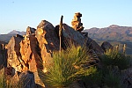
Okay this is a lousy pic on a very windy day but I don't have many at work. This should be easy for those in the know. Only a very short walk to get to it.
Okay this is a lousy pic on a very windy day but I don't have many at work. This should be easy for those in the know. Only a very short walk to get to it.
- Attachments
-
"Don't do today what you can put off 'till tomorrow." (Work that is!)
-
sthughes - Lagarostrobos franklinii
- Posts: 2427
- Joined: Wed 05 Mar, 2008 12:53 pm
- Location: Ulverstone
- Region: Tasmania
- Gender: Male
Re: Game - "Where am I ?"
![]() by Taurë-rana » Thu 18 Jun, 2009 3:43 pm
by Taurë-rana » Thu 18 Jun, 2009 3:43 pm
Well done sthughes, that's right. I thought it might be a bit harder than that, which is why I made sure the two hazy mountains were in there. Google Earth obviously makes things too easy!
Peak bagging points: 170ish
Recent walks - Picton, Wylds Crag, Rogoona
Recent walks - Picton, Wylds Crag, Rogoona
-

Taurë-rana - Athrotaxis selaginoides

- Posts: 1031
- Joined: Mon 14 Jan, 2008 8:28 pm
- Location: Devonport
- Region: Tasmania
Re: Game - "Where am I ?"
![]() by sthughes » Thu 18 Jun, 2009 3:44 pm
by sthughes » Thu 18 Jun, 2009 3:44 pm
Lol - like stealing candy from a baby
"Don't do today what you can put off 'till tomorrow." (Work that is!)
-
sthughes - Lagarostrobos franklinii
- Posts: 2427
- Joined: Wed 05 Mar, 2008 12:53 pm
- Location: Ulverstone
- Region: Tasmania
- Gender: Male
Re: Game - "Where am I ?"
![]() by eggs » Thu 18 Jun, 2009 3:47 pm
by eggs » Thu 18 Jun, 2009 3:47 pm
Devon Annie
it would have been diabolical without Cradle and Barn Bluff to get a fix on.
sthughes, surely you jest - "only a very short walk to get to it"
hmm - is it 5 days from Scott's Peak or 7 from Cockle Creek
Oh - I get it you flew in, and then hopped on a boat!
Or perhaps you mean a very short walk off the main track?
-
eggs - Lagarostrobos franklinii
- Posts: 10495
- Joined: Fri 23 May, 2008 2:58 pm
- Location: Para Vista, South Australia
- Region: South Australia
Re: Game - "Where am I ?"
![]() by sthughes » Thu 18 Jun, 2009 3:56 pm
by sthughes » Thu 18 Jun, 2009 3:56 pm
Sailed from Hobart to the foot of it in a yacht actually - then an easy stroll
Last edited by sthughes on Thu 18 Jun, 2009 3:56 pm, edited 1 time in total.
"Don't do today what you can put off 'till tomorrow." (Work that is!)
-
sthughes - Lagarostrobos franklinii
- Posts: 2427
- Joined: Wed 05 Mar, 2008 12:53 pm
- Location: Ulverstone
- Region: Tasmania
- Gender: Male
Re: Game - "Where am I ?"
![]() by stu » Thu 18 Jun, 2009 3:56 pm
by stu » Thu 18 Jun, 2009 3:56 pm
Mount Rugby from near Farrell Point (Bathurst Narrows)?
Having not been there, it's a guess!
Having not been there, it's a guess!
-
stu - Lagarostrobos franklinii
- Posts: 2174
- Joined: Fri 02 May, 2008 8:31 am
- Region: Tasmania
Re: Game - "Where am I ?"
![]() by sthughes » Thu 18 Jun, 2009 3:57 pm
by sthughes » Thu 18 Jun, 2009 3:57 pm
Come on whats the name of the place I'm standing? 

"Don't do today what you can put off 'till tomorrow." (Work that is!)
-
sthughes - Lagarostrobos franklinii
- Posts: 2427
- Joined: Wed 05 Mar, 2008 12:53 pm
- Location: Ulverstone
- Region: Tasmania
- Gender: Male
Re: Game - "Where am I ?"
![]() by sthughes » Thu 18 Jun, 2009 4:04 pm
by sthughes » Thu 18 Jun, 2009 4:04 pm
Got it! Well done - over to you.
"Don't do today what you can put off 'till tomorrow." (Work that is!)
-
sthughes - Lagarostrobos franklinii
- Posts: 2427
- Joined: Wed 05 Mar, 2008 12:53 pm
- Location: Ulverstone
- Region: Tasmania
- Gender: Male
Re: Game - "Where am I ?"
![]() by stu » Thu 18 Jun, 2009 4:07 pm
by stu » Thu 18 Jun, 2009 4:07 pm
Fluke! But I'll take it anyway.
This one I will make deliberately hard
You have until 5pm then I won't be back on until tomorrow morning I'm afraid.
Here we go:
This one I will make deliberately hard
You have until 5pm then I won't be back on until tomorrow morning I'm afraid.
Here we go:
-
stu - Lagarostrobos franklinii
- Posts: 2174
- Joined: Fri 02 May, 2008 8:31 am
- Region: Tasmania
Re: Game - "Where am I ?"
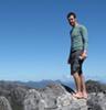
![]() by Mickeymoo » Thu 18 Jun, 2009 4:15 pm
by Mickeymoo » Thu 18 Jun, 2009 4:15 pm
I'm thinking its taken from very near the top of the Needles, with the thumbs in the top right corner, looks very familiar.
- Mickeymoo
- Athrotaxis cupressoides

- Posts: 412
- Joined: Fri 11 Jan, 2008 12:28 pm
- Location: Sandford
- Region: Tasmania
- Gender: Male
Re: Game - "Where am I ?"
![]() by stu » Thu 18 Jun, 2009 4:17 pm
by stu » Thu 18 Jun, 2009 4:17 pm
Nice work Michael, looking west over the Florentine Valley from the summit of The Needles.
Thought that one might be harder, looking like we all know our backyard pretty well.
Batter up...
Thought that one might be harder, looking like we all know our backyard pretty well.
Batter up...
-
stu - Lagarostrobos franklinii
- Posts: 2174
- Joined: Fri 02 May, 2008 8:31 am
- Region: Tasmania
Re: Game - "Where am I ?"
![]() by Mickeymoo » Thu 18 Jun, 2009 4:28 pm
by Mickeymoo » Thu 18 Jun, 2009 4:28 pm
Yes I'v been up there a number of times now, one of my favourite little walks! I'm just leaving work now so I will post one up within the next hour when I get home. Patience Adam
- Mickeymoo
- Athrotaxis cupressoides
- Posts: 412
- Joined: Fri 11 Jan, 2008 12:28 pm
- Location: Sandford
- Region: Tasmania
- Gender: Male
Re: Game - "Where am I ?"
![]() by Mickeymoo » Thu 18 Jun, 2009 5:25 pm
by Mickeymoo » Thu 18 Jun, 2009 5:25 pm
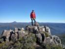
OK here is the next one then.
- Attachments
-
- _MG_0004A_filtered.jpg (226.44 KiB) Viewed 62186 times
- Mickeymoo
- Athrotaxis cupressoides
- Posts: 412
- Joined: Fri 11 Jan, 2008 12:28 pm
- Location: Sandford
- Region: Tasmania
- Gender: Male
Re: Game - "Where am I ?"
![]() by eggs » Thu 18 Jun, 2009 5:42 pm
by eggs » Thu 18 Jun, 2009 5:42 pm
Michael
you do know that is the second time you have put that photo on the forum, don't you?
Oh well - you didn't label the first one either, so that may not be much of a clue.
you do know that is the second time you have put that photo on the forum, don't you?
Oh well - you didn't label the first one either, so that may not be much of a clue.
-
eggs - Lagarostrobos franklinii
- Posts: 10495
- Joined: Fri 23 May, 2008 2:58 pm
- Location: Para Vista, South Australia
- Region: South Australia
Re: Game - "Where am I ?"
![]() by kramster » Thu 18 Jun, 2009 5:56 pm
by kramster » Thu 18 Jun, 2009 5:56 pm
I knew I recognised that peak...
Ok, lets take a wild guess... View from Mt Hesperus (Moraine A) on the Western Arthurs.
Ok, lets take a wild guess... View from Mt Hesperus (Moraine A) on the Western Arthurs.
-

kramster - Athrotaxis cupressoides
- Posts: 235
- Joined: Wed 05 Dec, 2007 10:18 am
- Location: Hobart, Tasmania
- Region: Tasmania
- Gender: Male
Re: Game - "Where am I ?"
![]() by Nick S » Thu 18 Jun, 2009 6:02 pm
by Nick S » Thu 18 Jun, 2009 6:02 pm
mt anne silhouette is quite distinctive, and sarah jane just confirms it.. ah somehow this photo makes it only seem a short way out to lake pedder.. bit of zoom i guess
-
Nick S - Phyllocladus aspleniifolius
- Posts: 624
- Joined: Thu 20 Mar, 2008 4:55 pm
- Location: Launceston
- Region: Tasmania
- Gender: Male
Re: Game - "Where am I ?"
![]() by eggs » Thu 18 Jun, 2009 6:06 pm
by eggs » Thu 18 Jun, 2009 6:06 pm
kramster
Moraine A and Hesperus are not quite the same place.
You may like to look back at the panorama on the first page of this topic - which was taken from Hesperus and then make a choice.
Moraine A and Hesperus are not quite the same place.
You may like to look back at the panorama on the first page of this topic - which was taken from Hesperus and then make a choice.
-
eggs - Lagarostrobos franklinii
- Posts: 10495
- Joined: Fri 23 May, 2008 2:58 pm
- Location: Para Vista, South Australia
- Region: South Australia
Re: Game - "Where am I ?"
![]() by tasadam » Thu 18 Jun, 2009 6:22 pm
by tasadam » Thu 18 Jun, 2009 6:22 pm
Sentinals rings a bell.
EDIT. But I just checked your older sentinal photos and wrong angle so I'll guess Needles.
EDIT. But I just checked your older sentinal photos and wrong angle so I'll guess Needles.
-
tasadam - Magnus administratio
- Posts: 5941
- Joined: Tue 10 Apr, 2007 6:58 pm
- Location: Near Devonport, Tasmania
- ASSOCIATED ORGANISATIONS: TasmaniART, Smitten Merino, Macpac
- Region: Tasmania
- Gender: Male
Return to Games and Competitions
Who is online
Users browsing this forum: No registered users and 29 guests