Game: Where-is-it (Aussie)
Only administrators may post new topics to this forum. Registered users can post replies.
Re: Game: Where-is-it (Aussie)
![]() by peregrinator » Fri 30 Dec, 2022 9:23 am
by peregrinator » Fri 30 Dec, 2022 9:23 am
- peregrinator
- Athrotaxis selaginoides

- Posts: 1784
- Joined: Fri 15 Apr, 2011 2:50 pm
- Region: Victoria
Re: Game: Where-is-it (Aussie)
![]() by peregrinator » Sat 31 Dec, 2022 7:07 am
by peregrinator » Sat 31 Dec, 2022 7:07 am
- peregrinator
- Athrotaxis selaginoides
- Posts: 1784
- Joined: Fri 15 Apr, 2011 2:50 pm
- Region: Victoria
Re: Game: Where-is-it (Aussie)
![]() by johnw » Sat 31 Dec, 2022 8:45 am
by johnw » Sat 31 Dec, 2022 8:45 am
peregrinator wrote:Classification as Lake or River essentially being determined by flood level, I suppose. I emphasised the fact that the photograph was taken in Victoria. Rivers can be state borders.
This is making me think the Murray. It looks well forested and perhaps a milder climate than the western parts. I don't know it but I'll try Barmah Lake.
In Nature's keeping they are safe, but through the agency of man destruction is making rapid progress - John Muir c1912
-
johnw - Lagarostrobos franklinii

- Posts: 9163
- Joined: Wed 23 Jan, 2008 11:59 am
- Location: Macarthur Region - SW Sydney
- Region: New South Wales
- Gender: Male
Re: Game: Where-is-it (Aussie)
![]() by Last » Sat 31 Dec, 2022 10:14 am
by Last » Sat 31 Dec, 2022 10:14 am
- Last
- Lagarostrobos franklinii
- Posts: 2206
- Joined: Thu 23 Jun, 2016 3:43 pm
- Region: Tasmania
Re: Game: Where-is-it (Aussie)
![]() by peregrinator » Sat 31 Dec, 2022 3:39 pm
by peregrinator » Sat 31 Dec, 2022 3:39 pm
Last wrote:it reminds me of the country around Hume weir. Parks on the victorian side include mt Granya?
And also include . . .
- peregrinator
- Athrotaxis selaginoides
- Posts: 1784
- Joined: Fri 15 Apr, 2011 2:50 pm
- Region: Victoria
Re: Game: Where-is-it (Aussie)
![]() by Last » Sat 31 Dec, 2022 7:30 pm
by Last » Sat 31 Dec, 2022 7:30 pm
- Last
- Lagarostrobos franklinii
- Posts: 2206
- Joined: Thu 23 Jun, 2016 3:43 pm
- Region: Tasmania
Re: Game: Where-is-it (Aussie)
![]() by peregrinator » Sun 01 Jan, 2023 5:42 am
by peregrinator » Sun 01 Jan, 2023 5:42 am
Last wrote:Mt Lawson?
Yes, Mount Lawson State Park. At the northern end, looking at Lake Hume/Hume Dam. Both names are in use. Not far east from here, the name reverts to Murray River.
- peregrinator
- Athrotaxis selaginoides
- Posts: 1784
- Joined: Fri 15 Apr, 2011 2:50 pm
- Region: Victoria
Re: Game: Where-is-it (Aussie)
![]() by Last » Sun 01 Jan, 2023 10:20 am
by Last » Sun 01 Jan, 2023 10:20 am
- Attachments
-
- the Nattai from the lookout at the end of the Boxvale track, above the skip incline
- Last
- Lagarostrobos franklinii
- Posts: 2206
- Joined: Thu 23 Jun, 2016 3:43 pm
- Region: Tasmania
Re: Game: Where-is-it (Aussie)
![]() by johnw » Mon 02 Jan, 2023 2:25 pm
by johnw » Mon 02 Jan, 2023 2:25 pm
EDIT: Now I can. I'm pretty sure it's the Nattai from the lookout at the end of the Boxvale track, above the skip incline.
In Nature's keeping they are safe, but through the agency of man destruction is making rapid progress - John Muir c1912
-
johnw - Lagarostrobos franklinii
- Posts: 9163
- Joined: Wed 23 Jan, 2008 11:59 am
- Location: Macarthur Region - SW Sydney
- Region: New South Wales
- Gender: Male
Re: Game: Where-is-it (Aussie)
![]() by Last » Mon 02 Jan, 2023 6:53 pm
by Last » Mon 02 Jan, 2023 6:53 pm
- Last
- Lagarostrobos franklinii
- Posts: 2206
- Joined: Thu 23 Jun, 2016 3:43 pm
- Region: Tasmania
Re: Game: Where-is-it (Aussie)
![]() by johnw » Mon 02 Jan, 2023 9:35 pm
by johnw » Mon 02 Jan, 2023 9:35 pm
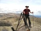
What did I visit on Saturday in the ACT:
- Approaching Mt Painter, Mt Painter Nature Reserve/Canberra Nature Park via Cook ACT
In Nature's keeping they are safe, but through the agency of man destruction is making rapid progress - John Muir c1912
-
johnw - Lagarostrobos franklinii
- Posts: 9163
- Joined: Wed 23 Jan, 2008 11:59 am
- Location: Macarthur Region - SW Sydney
- Region: New South Wales
- Gender: Male
Re: Game: Where-is-it (Aussie)
![]() by johnw » Tue 03 Jan, 2023 4:03 pm
by johnw » Tue 03 Jan, 2023 4:03 pm
In Nature's keeping they are safe, but through the agency of man destruction is making rapid progress - John Muir c1912
-
johnw - Lagarostrobos franklinii
- Posts: 9163
- Joined: Wed 23 Jan, 2008 11:59 am
- Location: Macarthur Region - SW Sydney
- Region: New South Wales
- Gender: Male
Re: Game: Where-is-it (Aussie)
![]() by jonnosan » Wed 04 Jan, 2023 5:54 am
by jonnosan » Wed 04 Jan, 2023 5:54 am
-

jonnosan - Phyllocladus aspleniifolius

- Posts: 896
- Joined: Fri 27 Jan, 2012 4:06 pm
- Region: New South Wales
- Gender: Male
Re: Game: Where-is-it (Aussie)
![]() by johnw » Wed 04 Jan, 2023 10:38 am
by johnw » Wed 04 Jan, 2023 10:38 am
jonnosan wrote:combing the clue with a list of ACT trig markers - is it Mt Painter?
Correct jonnosan. We were in Canberra last week so I managed a few ACT day walks.
Visited Mt Painter after doing Big Monks on Saturday morning.
In Nature's keeping they are safe, but through the agency of man destruction is making rapid progress - John Muir c1912
-
johnw - Lagarostrobos franklinii
- Posts: 9163
- Joined: Wed 23 Jan, 2008 11:59 am
- Location: Macarthur Region - SW Sydney
- Region: New South Wales
- Gender: Male
Re: Game: Where-is-it (Aussie)
![]() by jonnosan » Wed 04 Jan, 2023 2:24 pm
by jonnosan » Wed 04 Jan, 2023 2:24 pm
Keeping on the trig theme, whats the name of the trig I am looking at here (NSW)?
Flat Top viewed from Fortress Ridge track
-
jonnosan - Phyllocladus aspleniifolius
- Posts: 896
- Joined: Fri 27 Jan, 2012 4:06 pm
- Region: New South Wales
- Gender: Male
Re: Game: Where-is-it (Aussie)
![]() by johnw » Wed 04 Jan, 2023 7:03 pm
by johnw » Wed 04 Jan, 2023 7:03 pm
In Nature's keeping they are safe, but through the agency of man destruction is making rapid progress - John Muir c1912
-
johnw - Lagarostrobos franklinii
- Posts: 9163
- Joined: Wed 23 Jan, 2008 11:59 am
- Location: Macarthur Region - SW Sydney
- Region: New South Wales
- Gender: Male
Re: Game: Where-is-it (Aussie)
![]() by jonnosan » Wed 04 Jan, 2023 7:43 pm
by jonnosan » Wed 04 Jan, 2023 7:43 pm
johnw wrote:Is it Flat Top from the Lockley track?
You are correct on it being Flat Top, but its from the fortress ridge track, not Lockley
-
jonnosan - Phyllocladus aspleniifolius
- Posts: 896
- Joined: Fri 27 Jan, 2012 4:06 pm
- Region: New South Wales
- Gender: Male
Re: Game: Where-is-it (Aussie)
![]() by johnw » Wed 04 Jan, 2023 10:18 pm
by johnw » Wed 04 Jan, 2023 10:18 pm
jonnosan wrote:johnw wrote:Is it Flat Top from the Lockley track?
You are correct on it being Flat Top, but its from the fortress ridge track, not Lockley
Ah yes, that makes sense now.
Another trig then, NSW:
- Near Castle Cliff trig on Castle Head, Blue Mountains NP via Katoomba NSW
In Nature's keeping they are safe, but through the agency of man destruction is making rapid progress - John Muir c1912
-
johnw - Lagarostrobos franklinii
- Posts: 9163
- Joined: Wed 23 Jan, 2008 11:59 am
- Location: Macarthur Region - SW Sydney
- Region: New South Wales
- Gender: Male
Re: Game: Where-is-it (Aussie)
![]() by Walk_fat boy_walk » Thu 05 Jan, 2023 5:38 pm
by Walk_fat boy_walk » Thu 05 Jan, 2023 5:38 pm
Sent from my SM-S906E using Tapatalk
- Walk_fat boy_walk
- Lagarostrobos franklinii
- Posts: 2105
- Joined: Sat 21 Nov, 2009 6:59 am
- Gender: Male
Re: Game: Where-is-it (Aussie)
![]() by johnw » Thu 05 Jan, 2023 7:02 pm
by johnw » Thu 05 Jan, 2023 7:02 pm
Walk_fat boy_walk wrote:Jellore?
Not in the Nattai area, closer to the previous photo.
In Nature's keeping they are safe, but through the agency of man destruction is making rapid progress - John Muir c1912
-
johnw - Lagarostrobos franklinii
- Posts: 9163
- Joined: Wed 23 Jan, 2008 11:59 am
- Location: Macarthur Region - SW Sydney
- Region: New South Wales
- Gender: Male
Re: Game: Where-is-it (Aussie)
![]() by Tyreless » Thu 05 Jan, 2023 7:18 pm
by Tyreless » Thu 05 Jan, 2023 7:18 pm
-

Tyreless - Phyllocladus aspleniifolius
- Posts: 973
- Joined: Thu 19 Feb, 2015 12:31 pm
- Location: Sydney Northern Beaches
- ASSOCIATED ORGANISATIONS: Sydney Bush Walkers
- Region: New South Wales
- Gender: Male
Re: Game: Where-is-it (Aussie)
![]() by johnw » Thu 05 Jan, 2023 9:30 pm
by johnw » Thu 05 Jan, 2023 9:30 pm
Tyreless wrote:Is it Hat Hill (prior to August 2020 - the vanes are no longer in place)?
Not Hat Hill Tyreless. You're in the general area but on the wrong side of the GWH.
In Nature's keeping they are safe, but through the agency of man destruction is making rapid progress - John Muir c1912
-
johnw - Lagarostrobos franklinii
- Posts: 9163
- Joined: Wed 23 Jan, 2008 11:59 am
- Location: Macarthur Region - SW Sydney
- Region: New South Wales
- Gender: Male
-
Tyreless - Phyllocladus aspleniifolius
- Posts: 973
- Joined: Thu 19 Feb, 2015 12:31 pm
- Location: Sydney Northern Beaches
- ASSOCIATED ORGANISATIONS: Sydney Bush Walkers
- Region: New South Wales
- Gender: Male
Re: Game: Where-is-it (Aussie)
![]() by johnw » Fri 06 Jan, 2023 10:21 am
by johnw » Fri 06 Jan, 2023 10:21 am
Tyreless wrote:Castle Cliff?
Correct Tyreless, Castle Cliff trig on Castle Head.
In Nature's keeping they are safe, but through the agency of man destruction is making rapid progress - John Muir c1912
-
johnw - Lagarostrobos franklinii
- Posts: 9163
- Joined: Wed 23 Jan, 2008 11:59 am
- Location: Macarthur Region - SW Sydney
- Region: New South Wales
- Gender: Male
Re: Game: Where-is-it (Aussie)
![]() by Tyreless » Fri 06 Jan, 2023 1:38 pm
by Tyreless » Fri 06 Jan, 2023 1:38 pm
- Attachments
-
-
Tyreless - Phyllocladus aspleniifolius
- Posts: 973
- Joined: Thu 19 Feb, 2015 12:31 pm
- Location: Sydney Northern Beaches
- ASSOCIATED ORGANISATIONS: Sydney Bush Walkers
- Region: New South Wales
- Gender: Male
Re: Game: Where-is-it (Aussie)
![]() by Walk_fat boy_walk » Fri 06 Jan, 2023 3:03 pm
by Walk_fat boy_walk » Fri 06 Jan, 2023 3:03 pm
- Walk_fat boy_walk
- Lagarostrobos franklinii
- Posts: 2105
- Joined: Sat 21 Nov, 2009 6:59 am
- Gender: Male
Re: Game: Where-is-it (Aussie)
![]() by Tyreless » Fri 06 Jan, 2023 3:14 pm
by Tyreless » Fri 06 Jan, 2023 3:14 pm
Walk_fat boy_walk wrote:Looking south from Mt Mouin?
That's it. There used to be a trig structure at Mt Mouin but it was de-piled some time prior to August 1977 by NPWS due to damage from walkers on some of the loose slopes (if I recall correctly). Jonnosan found information in the August 1977 edition of The Bushwalker magazine, but the link to the pdf no longer works and it’s not available at the Bushwalking NSW web site (a bit of a mystery).
-
Tyreless - Phyllocladus aspleniifolius
- Posts: 973
- Joined: Thu 19 Feb, 2015 12:31 pm
- Location: Sydney Northern Beaches
- ASSOCIATED ORGANISATIONS: Sydney Bush Walkers
- Region: New South Wales
- Gender: Male
Re: Game: Where-is-it (Aussie)
![]() by Walk_fat boy_walk » Fri 06 Jan, 2023 3:32 pm
by Walk_fat boy_walk » Fri 06 Jan, 2023 3:32 pm
This is in Vic:
- Attachments
-
- Walk_fat boy_walk
- Lagarostrobos franklinii
- Posts: 2105
- Joined: Sat 21 Nov, 2009 6:59 am
- Gender: Male
Re: Game: Where-is-it (Aussie)
![]() by jonnosan » Fri 06 Jan, 2023 5:48 pm
by jonnosan » Fri 06 Jan, 2023 5:48 pm
Tyreless wrote:Walk_fat boy_walk wrote:Looking south from Mt Mouin?
That's it. There used to be a trig structure at Mt Mouin but it was de-piled some time prior to August 1977 by NPWS due to damage from walkers on some of the loose slopes (if I recall correctly). Jonnosan found information in the August 1977 edition of The Bushwalker magazine, but the link to the pdf no longer works and it’s not available at the Bushwalking NSW web site (a bit of a mystery).
Hi Tyreless - there is a copy of that PDF on archive.org - https://web.archive.org/web/20210127110 ... t-1977.pdf
This is the article I was referring to on the GCA log (which I assume is what you were referencing)
- Capture.PNG (138.87 KiB) Viewed 2257 times
-
jonnosan - Phyllocladus aspleniifolius
- Posts: 896
- Joined: Fri 27 Jan, 2012 4:06 pm
- Region: New South Wales
- Gender: Male
Re: Game: Where-is-it (Aussie)
![]() by Tyreless » Fri 06 Jan, 2023 5:55 pm
by Tyreless » Fri 06 Jan, 2023 5:55 pm
-
Tyreless - Phyllocladus aspleniifolius
- Posts: 973
- Joined: Thu 19 Feb, 2015 12:31 pm
- Location: Sydney Northern Beaches
- ASSOCIATED ORGANISATIONS: Sydney Bush Walkers
- Region: New South Wales
- Gender: Male
Return to Games and Competitions
Who is online
Users browsing this forum: No registered users and 11 guests