Hi all, just wanting some info on the Sentinel Ranges please as there doesn’t seem to be a huge amount online.
I have read there is a track from Wedge River Picnic Grounds, but it isn’t give a heap of information on time to the top & track condition.
TIA
Sentinel Ranges
Forum rules
Tasmania specific bushwalking discussion. Please avoid publishing details of access to sensitive areas with no tracks.
Tasmania specific bushwalking discussion. Please avoid publishing details of access to sensitive areas with no tracks.
4 posts
• Page 1 of 1
Sentinel Ranges
![]() by footsteps87 » Mon 24 Aug, 2020 6:48 am
by footsteps87 » Mon 24 Aug, 2020 6:48 am
- footsteps87
- Nothofagus gunnii

- Posts: 18
- Joined: Tue 10 Apr, 2018 6:25 am
- Region: Tasmania
- Gender: Female
Re: Sentinel Ranges
![]() by johnw » Mon 24 Aug, 2020 9:26 am
by johnw » Mon 24 Aug, 2020 9:26 am
I did the walk some years ago, Tassie locals would have more up to date info. Especially regarding any track closures etc following the SW fires.
But yes, there is a well defined track from the Wedge River Picnic Ground. Quite steep once you start the ascent proper, but not overly difficult.
I found it a tight fit in places as the scrub encroaches a bit, making it somewhat narrow. I can't recall the exact time we took, and we did it in the rain which slowed us down.
I'd guess maybe 1.5 hours each way as a ball park estimate (YMMV). Due to the sketchy weather once we reached the tops we didn't go up to the true summit, so allow extra time for that.
Thought I had track notes somewhere, either written or online. If I manage to unearth them I'll update this.
John W
In Nature's keeping they are safe, but through the agency of man destruction is making rapid progress - John Muir c1912
In Nature's keeping they are safe, but through the agency of man destruction is making rapid progress - John Muir c1912
-
johnw - Lagarostrobos franklinii

- Posts: 9031
- Joined: Wed 23 Jan, 2008 11:59 am
- Location: Macarthur Region - SW Sydney
- Region: New South Wales
- Gender: Male
Re: Sentinel Ranges
![]() by L_Cham_67 » Mon 24 Aug, 2020 10:04 am
by L_Cham_67 » Mon 24 Aug, 2020 10:04 am
1.5-2 hours one way sounds about right.
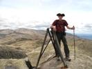
You have to cross the Wedge River on a log right at the beginning of the walk, which might not be possible after heavy rain. It's steep to begin with, as you head up buttongrass and then underneath the cliff faces and outcrops. Much of the walk has been burnt sometime recently, so you only really have to push through scrub once you reach the ridge over the last few hundred metres to the summit (but there is a track to follow). This final ridge is narrow with significant drop offs on the Lake Pedder side especially.
Great views from the top however.
-
L_Cham_67 - Athrotaxis selaginoides

- Posts: 1045
- Joined: Thu 17 Dec, 2015 6:43 pm
- Region: Tasmania
- Gender: Male
Re: Sentinel Ranges
![]() by RicktheHuman » Mon 24 Aug, 2020 10:10 am
by RicktheHuman » Mon 24 Aug, 2020 10:10 am
Take care around the ridgeline in cloudy or wet/snowy conditions. There are some big drops and there was a very sad and unfortunate incident there recently.
I lika do da cha-cha
-
RicktheHuman - Athrotaxis cupressoides

- Posts: 499
- Joined: Thu 11 Dec, 2014 2:43 pm
- Region: Tasmania
- Gender: Male
4 posts
• Page 1 of 1
Who is online
Users browsing this forum: No registered users and 36 guests