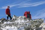
Here are some notes I created for the trip two of us did last Sunday, 13 Jan 2019. We started at Kedumba Pass at 7:35am, down to the valley via Goat Track (both sections). Up Korrowall Ridge in attempt to get up to Mt Solitary via Point Repulse. It took longer than expected and we felt the shale ledge section was too exposed to go pass and it was 6:30pm. So we decided to descend directly back to the fire trail down and got back to our car at about 10:30pm.
- GPX Tracking
Korrowall Ridge Trip Note
1. Goat Track Top Section: Alt 655m → 535m; Distance 0.26km
There is a cairn at the top entrance. The first half is a steep scramble down (30% grad) a clear gully. The second half is less steep (15% grad) and more improvisible, possibly leading to 100m north of the lock gate, where there is a 4WD track branches off the opposite side of Kedumba Pass.
2. Goat Track Bottom Section: Alt 485m → 275m; Distance 0.76km
There is a cairn at the top entrance, located about 100m south of the lock gate, where the road bends to the left. The first 2/3 is rather open and gentle, until Alt 350m where there is a cliff. At our particular spot of descend, it is a 3m climb with medium difficulty, followed by another few meters of less vertical climb. Not sure if the cliff is by-passable. The bottom 1/3 has more dense vegetation and we generally follow a gully until we hit the 4WD track branches off Kedumba Pass.
3. Kedumba Valley: Alt 150m
Point of Interests: Maxwell Historical Site, Maxwell Memorial, Kedumba Valley Campground, Kedumba River Crossing (water at lower-shin level). Lots of flies!
4. Steep and Rugged Climb: Alt 415m → 575m; Distance 0.50km
Turn right (west) towards Korrowall Ridge after walking 3.08km from the Mt Solitary Track turnoff, just before the Restricted Zone sign. There is a cliff at Alt 450m after some rather steep yet manageable scramble. We have checked the left (south) of the cliff and cannot find an easier way, but we haven’t checked the right (north). This cliff is about 8m with some hand holds that strong upper body would be beneficial. There are spots for short rests through the climb. The next section is a longer scramble and is a little easier than the earlier one below the cliff. We reached Korrowall Ridge at the point where there is a distinctive ant hill.
5. Korrowall Ridge: Alt 575m → 675m; Distance 0.90km
It is a rather easy section. There is a campsite along the way in the first flatter section. Later on it gets steeper as it approaches the bluffy section. The boulders get bigger and bigger and eventually it is impossible to keep following the ridge.
6. Rock Outcrop Section: Alt 675m → 730m; Distance 0.90km
Here a decision has to be made on each outcrop, whether to climb directly up (while there is a chance to have no way down the other side and not connected to the next outcrop), or stay left or right of the bottom of the outcrop and whether to climb up along the way or just to get around it. We have not tested all possible ways and we just go by our instinct. It looks like the left side is more promising than the right in many cases. And the straight up solution often leads to a back track as the tops do not connect.
One of the outcrops (or more; that we didn’t explore) provides excellent 360 degree views. We stayed on the left of the bigger and bigger outcrops (now become a cliff on our right) to a point where we must go back up to a higher position. A 10m climb is facing us. It is quite reasonable with holds. After this climb and a bit more scramble we get to the top of the outcrop which does not connect to the next. We found a way down, again on the left, going around and through a rather narrow col it connects to the next outcrop (the final one before Point Repulse).
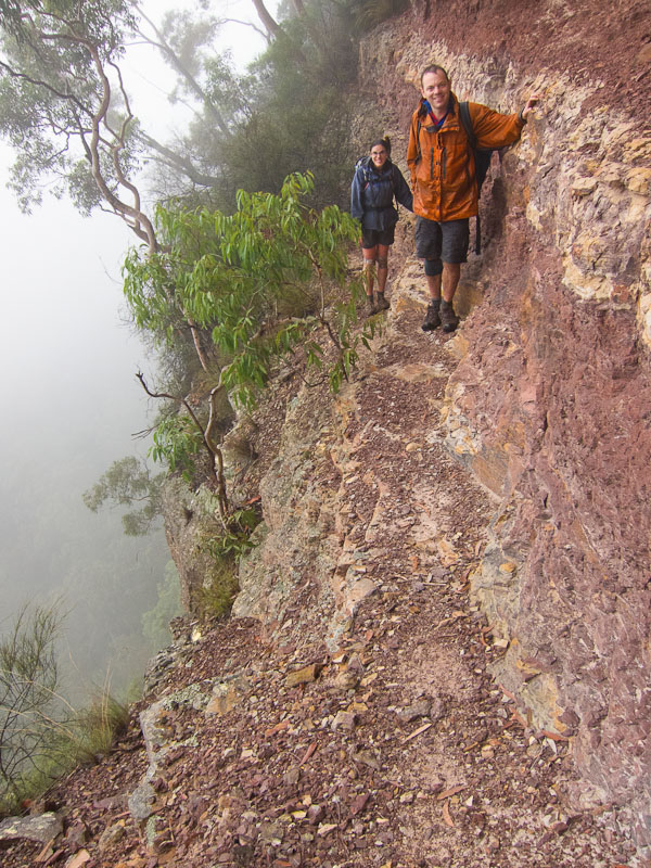
From other’s track report we know that the Shale Ledge is on the right (East) of the cliff, so this time we get to the right (cliff is now on our left). It then leads to a point where it becomes impassable going forward. So our only choice is to scramble down to our right (East). This scramble is initially a 45 degree slope with limited holds followed by a 2’ish meter drop, with some footings only when we can see them i.e. after we get down! We don’t have a tape or rope. But I have a K-mart resistance band (the ones for stretching / strength training) which becomes handy when we try to get down bit by bit with the upper person being the anchor holding one side of the band. At one stage I need to dig holes on the loose earth to create handholds. I know it is dodgy, but it works! After we both get down, we follow the bottom of the cliff and keep ourselves close to the cliff and it gradually leads up to the final scramble section. All these efforts of up and down outcrops may actually be avoidable if we just stay on the right of the bluffs all the way through, which should lead us to the same final scramble.
7. Final Scramble to Shale Ledge: Alt 730m → 760m; Distance 0.20km
The final scramble is steep but not difficult. We can see traces of footprint on the ground. The scramble leads us to a flat area directly in front of Point Repulse. There is a cairn in this area. The following section becomes very apparent: a red shale ledge on the right of the cliff. After walking on the ledge for about 20m, there is a crack that could be climbable to the top. But the intended way is to continue going forward to the narrowest part of the shale ledge, with a 15-degree slant section just before that. This is a very exposed section with shale cliff on the left and sheer 100m drop on the right.
8. Yuslan Descend: Alt 730m → 410m; Distance 1.20km
(Name after a party of two, Yus and Alan): from the base of the final scramble (while still next to the cliff), find a convenient place to descend (due East) this steep section, after 0.6km, or Alt at 525m, the terrain becomes flat and it would be easier to get to the closest point of the fire trail by going SSE for 0.3km, until it steepens again. There seems to be a few gigantic fallen trees lying in this area. Now descend due East again for another 0.3km and you would uneventfully reach the fire trail where it bends 180 degrees.