I recently hiked from Sassafras NSW through to Mount Owen in the Buddawangs and return with a side trip up Mount Hoddle. We used old fashioned maps and I tried Pocket Earth for a gps and topo on my iPhone+
I didn’t do full tracking as gps chews through battery. It was handy but the map quality is poor so makes serious orienteering difficult. Also you can’t update your route when your off line.
I Looked at the map on Memory Maps but the quality didn’t look any better. It’s pricy but apparently you can do a lot more on a pc and then print as well as the smartphone app.
What apps are others using? Any feedback on them would be great.
Topographic map apps
52 posts
• Page 1 of 2 • 1, 2
Topographic map apps
![]() by Parley4 » Fri 15 Jun, 2018 11:45 am
by Parley4 » Fri 15 Jun, 2018 11:45 am
- Parley4
- Nothofagus cunninghamii

- Posts: 2
- Joined: Thu 14 Jun, 2018 6:13 am
- Region: New South Wales
- Gender: Male
Re: Topographic map apps
![]() by wildwanderer » Fri 15 Jun, 2018 12:51 pm
by wildwanderer » Fri 15 Jun, 2018 12:51 pm
Oruxmaps is great as you can upload government topos in high res pdf (available from govt site free). The app is free and you can import routes created on pc. (also create routes on the app)
I use it for all my navigation on and off track. However it is only for Android.
I use it for all my navigation on and off track. However it is only for Android.
-

wildwanderer - Athrotaxis selaginoides

- Posts: 1640
- Joined: Tue 02 May, 2017 8:42 am
- Location: Out of lockdown \o/
- Region: New South Wales
- Gender: Male
Re: Topographic map apps
![]() by ChrisJHC » Fri 15 Jun, 2018 9:50 pm
by ChrisJHC » Fri 15 Jun, 2018 9:50 pm
Interesting. I use Pocket Earth all the time on my iPhone and find it perfect for my purposes.
The map quality is certainly good enough for me.
The map quality is certainly good enough for me.
- ChrisJHC
- Phyllocladus aspleniifolius

- Posts: 786
- Joined: Sat 25 Feb, 2017 8:22 pm
- Region: Victoria
- Gender: Male
Re: Topographic map apps
![]() by crollsurf » Fri 15 Jun, 2018 10:46 pm
by crollsurf » Fri 15 Jun, 2018 10:46 pm
I'm quite happy with Gaia which uses OpenStreetMaps, OSM in Australia. I think Pocket Earth uses OSM as well. One thing you have to do is download the map before you go but just as important, download to the highest resolution. Gaia calls it "Max Zoom" but it defaults to a level of resolution which is OK but not ideal. At Max "Max Zoom" its good.
-

crollsurf - Lagarostrobos franklinii

- Posts: 2252
- Joined: Tue 07 Mar, 2017 10:07 am
- Location: Sydney
- Region: New South Wales
- Gender: Male
Re: Topographic map apps
![]() by Orion » Sat 16 Jun, 2018 9:31 am
by Orion » Sat 16 Jun, 2018 9:31 am
I like Gaia too but don't like the yearly subscription model. So when that runs out I'm going to toss it and just use MapOut. It's not as fancy and doesn't have all of the features that Gaia has. But the open source maps are actually rendered better than on Gaia, in my opinion. For just finding yourself on a map it works pretty well for a one-time fee of $5 versus a yearly subscription charge of $20 (or $40 for premium maps) for Gaia.
MapOut has a feature I find quite useful and it's something that Gaia lacks. MapOut displays the GPS precision as a circle around your location. When you're locked into a bunch of satellites the circle is tiny. But when the GPS lock is poor the circle increases in size to denote the uncertainty. And when there is no lock at all the location button blinks. Gaia shows you it's best guess without any extra information. When there's no lock at all it simply tells you that you are where you were last time it had a lock -- that can be a long, long ways away from your actual location. So even when I'm using Gaia's features I find myself bringing up MapOut just to see if the GPS is getting a lock, and if so, how good it is.
In Tasmania I've used Avenza's free app because they carry the Tasmap maps (which are not free). It's not a very good interface but the map resolution is the best available for Tasmania. I don't know what maps they offer elsewhere. The maps can add up in cost. They are a one-time purchase though... at least for as long as the app is supported.
- Orion
- Athrotaxis selaginoides
- Posts: 1963
- Joined: Mon 02 Feb, 2009 12:33 pm
- Region: Other Country
Re: Topographic map apps
![]() by Parley4 » Sun 17 Jun, 2018 9:09 am
by Parley4 » Sun 17 Jun, 2018 9:09 am
Thanks for all the replies. It sounds like I need an Android. OSM lacks a lot of detail that the central mapping authority has such as cliff lines and relative heights. Vital information for planning an off track excursion and very handy for finding your location. Gps is a great tool but struggles in claudy weather let alone with mountains and cliffs.
@Wildwanderer. Can u use Uruxmaps on a pc? Or is it possible to download the CMA maps to a pc for planning purposes. Then they could also be printed
Good old CMA topos and a compass are still a must in my book.
I love having topographics handy on my phone though. I’ll check out some of the other apps suggested.
Thanks again.
- Parley4
- Nothofagus cunninghamii
- Posts: 2
- Joined: Thu 14 Jun, 2018 6:13 am
- Region: New South Wales
- Gender: Male
Re: Topographic map apps
![]() by Orion » Sun 17 Jun, 2018 10:45 am
by Orion » Sun 17 Jun, 2018 10:45 am
One approach is to use the GPS mapping app to find yourself on the map. Then you can refer to the paper map for finer details. You don't want to be out there with just a phone anyway.
That's what I would have done in Tasmania but the high resolution paper maps are no longer available for many locations. So, weirdly, the electronic maps were much better than the paper maps I had with me.
That's what I would have done in Tasmania but the high resolution paper maps are no longer available for many locations. So, weirdly, the electronic maps were much better than the paper maps I had with me.
- Orion
- Athrotaxis selaginoides
- Posts: 1963
- Joined: Mon 02 Feb, 2009 12:33 pm
- Region: Other Country
Re: Topographic map apps
![]() by Warin » Sun 17 Jun, 2018 12:30 pm
by Warin » Sun 17 Jun, 2018 12:30 pm
Parley4 wrote:OSM lacks a lot of detail that the central mapping authority has such as cliff lines and relative heights. Vital information for planning an off track excursion and very handy for finding your location.
You may be able to add that detail to OSM.
If you have personal knowldege of it then add it, do not copy it from a copyright source.
There are various things that can help put features into OSM - satellite views for instance.
It can take sometime for the additions to get through to some apps. OSMand can be 2 months.
Parley4 wrote: Gps is a great tool but struggles in claudy weather let alone with mountains and cliffs.
But they work better than maps in fog
Parley4 wrote:Or is it possible to download the CMA maps to a pc for planning purposes.
If you can get the map in some format onto the PC then there will be some program that can use it.
-

Warin - Athrotaxis selaginoides
- Posts: 1429
- Joined: Sat 11 Nov, 2017 8:02 am
- Region: New South Wales
Re: Topographic map apps
![]() by tom_brennan » Sun 17 Jun, 2018 2:36 pm
by tom_brennan » Sun 17 Jun, 2018 2:36 pm
You can also download the topo tiles for OruxMaps, similar to what I do for my maps site: http://maps.ozultimate.com
There is a mobile topo only version at https://maps.ozultimate.com/topo/
The PDFs can be downloaded, but I find the seamless tiles handier.
However, for actual map and compass navigation, a phone screen is just too small - you can see where you are, but you can't see where you're going. Paper printouts (I use A4 or A3 printouts) are much more useful in the bush.
Bushwalking NSW - http://bushwalkingnsw.com
-

tom_brennan - Athrotaxis selaginoides
- Posts: 1366
- Joined: Wed 29 Sep, 2010 9:21 am
- Location: Sydney
- Region: New South Wales
- Gender: Male
Re: Topographic map apps
![]() by wildwanderer » Sun 17 Jun, 2018 4:35 pm
by wildwanderer » Sun 17 Jun, 2018 4:35 pm
Parley4 wrote: @Wildwanderer. Can u use Uruxmaps on a pc? Or is it possible to download the CMA maps to a pc for planning purposes.
What you do is create a route on your PC using one of the several online tools and then save that as a GPX file. Then import that gpx file into oruxmaps on your phone. (route shows up in orux maps and displays on which ever map you have imported into the phone/oruxmaps. (personally I have both openstreetmaps and govt topos so I can view the route on both at the press of a button)
For creating routes personally I use suuntos movescount because it intergrates with my watch however I can recommend Toms site. http://maps.ozultimate.com/ as you can use the nsw govt topos on pc to plan and draw your route and then save as gpx.
Most other solutions you can plan and create the route on pc only using openstreetmaps or google maps which are ok but dont have the contour precision that the govt topos do.
tom_brennan wrote:However, for actual map and compass navigation, a phone screen is just too small - you can see where you are, but you can't see where you're going. Paper printouts (I use A4 or A3 printouts) are much more useful in the bush.
hehe beg to differ Im quite comfortable navigating offtrack using the phone (map only, no gps) but each to their own. The latest phones high resolution/size is making things easier. I do agree that for route planning where your attempting to see greater than 6-8km (without scrolling) then the paper maps are superior.
-
wildwanderer - Athrotaxis selaginoides
- Posts: 1640
- Joined: Tue 02 May, 2017 8:42 am
- Location: Out of lockdown \o/
- Region: New South Wales
- Gender: Male
Re: Topographic map apps
![]() by Warin » Sun 17 Jun, 2018 6:15 pm
by Warin » Sun 17 Jun, 2018 6:15 pm
wildwanderer wrote:Parley4 wrote: hehe beg to differ Im quite comfortable navigating offtrack using the phone (map only, no gps) but each to their own. The latest phones high resolution/size is making things easier. I do agree that for route planning where your attempting to see greater than 6-8km (without scrolling) then the paper maps are superior.
If you have the route on your phone and navigating to that route .. yes.
If you have changed your plan then the paper map wins.
It also wins if you want others to comment on possible routes or to show them where you are.
One of the home PC programs I use is Oziexplorer ... works well with raster maps .. These can be had for any paper map - scan them in or photo them and then geo reference them. I have NSW + Vic covered at 25k, all of OZ at 250k. + some commercial maps + some NASA views + some Landsat views .. And then India at 25k, UK at 1" to the mile, bits of Africa .. etc etc. I can use it to create a gpx track .. not auto routing with raster info though.
-
Warin - Athrotaxis selaginoides
- Posts: 1429
- Joined: Sat 11 Nov, 2017 8:02 am
- Region: New South Wales
Re: Topographic map apps
![]() by warnesy » Sun 17 Jun, 2018 8:34 pm
by warnesy » Sun 17 Jun, 2018 8:34 pm
I still use memory maps, have for some time. The 25k are very good quality (even if you have to keep an eye on tracks not being in exactly the right place). Using the phone in airplane mode and occassional checking in, as well as taking photos i've gotten through 5 day hikes without needing a charge.
- warnesy
- Athrotaxis cupressoides

- Posts: 122
- Joined: Sat 04 Apr, 2015 12:57 pm
- Region: Australian Capital Territory
Re: Topographic map apps
![]() by keithy » Sun 17 Jun, 2018 10:47 pm
by keithy » Sun 17 Jun, 2018 10:47 pm
I haven't had much iPhone experience in the past 4 or so years, since I mainly use Android devices now. I know there have been some good topo map apps for iPhone like the previously mentioned Gaia, topo-maps and mudmaps though. The issue is going to be available map sources - I find it better if the apps can display custom scanned maps as well as using vector maps.
For Android, I have been using Oruxmaps since 2015 viewtopic.php?f=21&t=22380, and it's been great for my uses. Oruxmaps is Free (the free version is only available from http://www.oruxmaps.com) as Google Play removed it as it asked for donations through the app rather than a fixed price. I have paid for the "Donate" version through Google Play as the developer has been great in adding features over the years, but the free version and the "Donate" version are exactly the same.
I have used various other free and paid Android apps, like Locus maps, OSMAnd+, Avenza PDF, Terrago Edge, etc, but for me, I chose Oruxmaps initially as it could view my Garmin img formatted maps, and I could view the same maps on my Garmin handheld GPS units as well as the Android devices. What I would do was use the tablet to plan routes, and then transfer the created GPX file to my handheld Garmin GPS units.
Maps
For the maps, I have made my own as well - scanned printed maps (called raster maps), georeferenced and used them on the Garmin and tablets. But having been spoiled by a plethora of quality maps online from various sources like this one viewtopic.php?f=21&t=27634 or viewtopic.php?f=21&t=26065, I admit I have not made many custom maps in the past 3 years or so. Vector maps like OSM tend to be smaller and quicker to load vs raster maps.
It is true that OSM does not usually include details like cliffs, but if the data has been added, it can actually display this. As mentioned by ribuck in this post here viewtopic.php?f=63&t=22557&p=293380
I have been using andrew's compilation of OSM maps with contours for VIC/Tas viewtopic.php?f=21&t=14234&p=313210#p313210 for a while now, and they've been great. I also use online maps from various state land authorities.
Size/Readability issues
For overviewing maps, I've found that the bigger screens on phones and tablets these days to be better than paper maps for me. My eyes aren't as good as they used to be, and I like being able to zoom in rather than carrying a magnifying glass or fresnel lens to see details. I have no problem screen navigating large areas, as long as I have a wide view index map also loaded (like a 1:1mil or 1:500k).
Tablet/phone/GPS screens used to be poor in direct sunlight, but things have improved with newer devices.
And for me with multiday walks where I might be carrying multiple printed maps, I find it nicer to have all maps on one device that I can seamlessly navigate/zoom in & out. I usually still carry printed A4/A3 maps as well, but I notice I haven't referred to these as much of late.
Here are some pics to better illustrate:
Screensize comparison with my tablet/phone/Garmin GPS units
Tablet screen comparison with printed maps
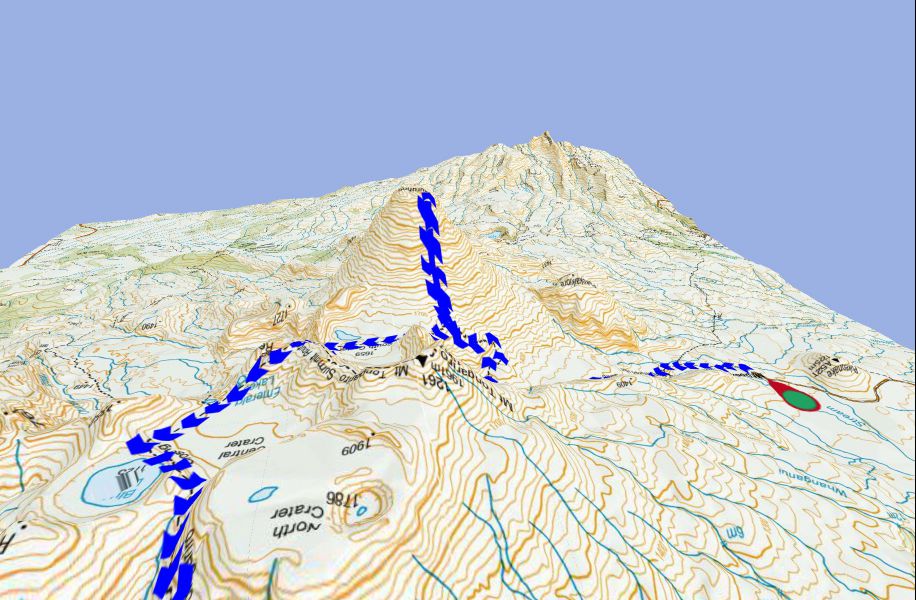
Below are some screenshots from my tablet which illustrates the detail that can be found on digital maps - this is the wonderful NZ Topo (a raster version) mbt format on Oruxmaps on my tablet. The NZ topo source is from LINZ (the NZ land authority) so are exactly as the printed maps, and includes 1:1 million, 1:250k, and 1:50k all seamlessly viewable in one offline file. As you zoom in on the map screen it seamlessly switches to the more detailed maps.
This is the 1:1m scale.
At this scale it is just an overview so it is easier to navigate the screen to the location you are interested in.
This is the 1:250k scale & zoomed in for detail
This is the 1:50k scale - you can see cliff markings for example are on this map
On top of that, Orux has the ability to use digital elevation model (DEM) files to display the map and your route in 3D. My Garmins can display these on some maps as well, but is significantly slower than on my phone/tablet.
Tom - that's a great mapping site. Nice work!
For Android, I have been using Oruxmaps since 2015 viewtopic.php?f=21&t=22380, and it's been great for my uses. Oruxmaps is Free (the free version is only available from http://www.oruxmaps.com) as Google Play removed it as it asked for donations through the app rather than a fixed price. I have paid for the "Donate" version through Google Play as the developer has been great in adding features over the years, but the free version and the "Donate" version are exactly the same.
I have used various other free and paid Android apps, like Locus maps, OSMAnd+, Avenza PDF, Terrago Edge, etc, but for me, I chose Oruxmaps initially as it could view my Garmin img formatted maps, and I could view the same maps on my Garmin handheld GPS units as well as the Android devices. What I would do was use the tablet to plan routes, and then transfer the created GPX file to my handheld Garmin GPS units.
Maps
For the maps, I have made my own as well - scanned printed maps (called raster maps), georeferenced and used them on the Garmin and tablets. But having been spoiled by a plethora of quality maps online from various sources like this one viewtopic.php?f=21&t=27634 or viewtopic.php?f=21&t=26065, I admit I have not made many custom maps in the past 3 years or so. Vector maps like OSM tend to be smaller and quicker to load vs raster maps.
It is true that OSM does not usually include details like cliffs, but if the data has been added, it can actually display this. As mentioned by ribuck in this post here viewtopic.php?f=63&t=22557&p=293380
I have been using andrew's compilation of OSM maps with contours for VIC/Tas viewtopic.php?f=21&t=14234&p=313210#p313210 for a while now, and they've been great. I also use online maps from various state land authorities.
Size/Readability issues
For overviewing maps, I've found that the bigger screens on phones and tablets these days to be better than paper maps for me. My eyes aren't as good as they used to be, and I like being able to zoom in rather than carrying a magnifying glass or fresnel lens to see details. I have no problem screen navigating large areas, as long as I have a wide view index map also loaded (like a 1:1mil or 1:500k).
Tablet/phone/GPS screens used to be poor in direct sunlight, but things have improved with newer devices.
And for me with multiday walks where I might be carrying multiple printed maps, I find it nicer to have all maps on one device that I can seamlessly navigate/zoom in & out. I usually still carry printed A4/A3 maps as well, but I notice I haven't referred to these as much of late.
Here are some pics to better illustrate:
Screensize comparison with my tablet/phone/Garmin GPS units
- Screensize comparison (phone not showing same map region... my bad)
Tablet screen comparison with printed maps
- Tablet Screen comparison (tablet is smidge smaller than A5)
Below are some screenshots from my tablet which illustrates the detail that can be found on digital maps - this is the wonderful NZ Topo (a raster version) mbt format on Oruxmaps on my tablet. The NZ topo source is from LINZ (the NZ land authority) so are exactly as the printed maps, and includes 1:1 million, 1:250k, and 1:50k all seamlessly viewable in one offline file. As you zoom in on the map screen it seamlessly switches to the more detailed maps.
This is the 1:1m scale.
At this scale it is just an overview so it is easier to navigate the screen to the location you are interested in.
- IMG_20180617_210550 (Small).png (693.62 KiB) Viewed 39969 times
This is the 1:250k scale & zoomed in for detail
- nztopo 1-250k_wm (Medium).jpg (297.85 KiB) Viewed 39969 times
This is the 1:50k scale - you can see cliff markings for example are on this map
- nztopo 1-50k_wm (Medium).jpg (267.51 KiB) Viewed 39969 times
On top of that, Orux has the ability to use digital elevation model (DEM) files to display the map and your route in 3D. My Garmins can display these on some maps as well, but is significantly slower than on my phone/tablet.
tom_brennan wrote:There is a mobile topo only version at https://maps.ozultimate.com/topo/
Tom - that's a great mapping site. Nice work!
-

keithy - Phyllocladus aspleniifolius
- Posts: 737
- Joined: Tue 28 Oct, 2014 5:31 pm
- Region: Other Country
- Gender: Male
Re: Topographic map apps
![]() by wildwanderer » Tue 19 Jun, 2018 8:21 am
by wildwanderer » Tue 19 Jun, 2018 8:21 am
Nice summary Keithy!
Do you know where I can download the OSM maps with contour/clifflines you referenced? http://bushwalk.com/forum/download/file.php?id=37000
I’m currently using https://www.openandromaps.org/en/legend ... hike-theme which displays clifflines/contours but I don’t like how the map author has put in colour coded track difficulty ratings. Its very distracting to have multiple coloured tracks everywhere and I found the suggested difficulty quite arbitrary and in quite a few cases wrong.
-
wildwanderer - Athrotaxis selaginoides
- Posts: 1640
- Joined: Tue 02 May, 2017 8:42 am
- Location: Out of lockdown \o/
- Region: New South Wales
- Gender: Male
Re: Topographic map apps
![]() by tom_brennan » Tue 19 Jun, 2018 2:57 pm
by tom_brennan » Tue 19 Jun, 2018 2:57 pm
wildwanderer wrote:... I found the suggested difficulty quite arbitrary and in quite a few cases wrong.
Sounds like you should jump on to OSM and fix up the difficulty ratings!!
Bushwalking NSW - http://bushwalkingnsw.com
-
tom_brennan - Athrotaxis selaginoides
- Posts: 1366
- Joined: Wed 29 Sep, 2010 9:21 am
- Location: Sydney
- Region: New South Wales
- Gender: Male
Re: Topographic map apps
![]() by ribuck » Tue 19 Jun, 2018 6:56 pm
by ribuck » Tue 19 Jun, 2018 6:56 pm
wildwanderer wrote:I don’t like how the map author has put in colour coded track difficulty ratings.
It's the theme author who defines the colours.
The theme file is a text file which you can edit. You can add an extra style to a theme, and define the display of tracks however you like.
Personally I love being able to see on the map the difference between a constructed track and a negotiable route.
When I find a map error, I often fix it after I get back from the trip. Mapmaking gets quite addictive once you overcome the learning curve.
-

ribuck - Athrotaxis selaginoides
- Posts: 1887
- Joined: Wed 15 May, 2013 3:47 am
- Region: Other Country
- Gender: Male
Re: Topographic map apps
![]() by Warin » Tue 19 Jun, 2018 8:14 pm
by Warin » Tue 19 Jun, 2018 8:14 pm
tom_brennan wrote:wildwanderer wrote:... I found the suggested difficulty quite arbitrary and in quite a few cases wrong.
Sounds like you should jump on to OSM and fix up the difficulty ratings!!
One of the problems with 'difficulty ratings' (or ratings of any sort) is the experience of the individual doing the rating.
What one could call 'hard' another could call 'easy'.
I have not bothered with most ratings ... there is lots that can be improved in most maps.
In OSM I have just extend 'Fairly Dell' Park (park IRRC, could be a reserve) from a single point to an area... much more meaning then.
-
Warin - Athrotaxis selaginoides
- Posts: 1429
- Joined: Sat 11 Nov, 2017 8:02 am
- Region: New South Wales
Re: Topographic map apps
![]() by keithy » Tue 19 Jun, 2018 9:04 pm
by keithy » Tue 19 Jun, 2018 9:04 pm
wildwanderer wrote:Nice summary Keithy!
Do you know where I can download the OSM maps with contour/clifflines you referenced? download/file.php?id=37000
That pic was from ribuck who was using OsmAnd with the contours plugin, on a Samsung Galaxy Note 3. I'm not sure which mapset he is using though.
In VIC, I have not seen cliff renderings pop up on the OSM maps I've used yet.
I’m currently using https://www.openandromaps.org/en/legend ... hike-theme which displays clifflines/contours but I don’t like how the map author has put in colour coded track difficulty ratings. Its very distracting to have multiple coloured tracks everywhere and I found the suggested difficulty quite arbitrary and in quite a few cases wrong.
I also have the tobias' Elevate mapsforge theme, and the Elements theme (more info for non-city areas), but I know what you mean about the colour coded tracks. As ribuck mentioned, the colours are from the theme author - in this case he has made them to correspond with German/Austrian printed maps styles. So the yellow, blue and red routes in Elevate described in the map key as below. The grading is in accordance with Swiss Alpine Club (SAC) Grading:
- Hiking (yellow) - flat or slightly sloped, no fall hazard, SAC T1
- Mountain Hiking (blue) - partially steep, fall hazard posssible, SAC T2
- Demanding Mountain Hiking (red) - not always visible, may be secured, hands may be needed paritally exposed with fall hazard, SAC T3
- Difficult/demanding Alpine hiking/Via Ferrata (Black) - no trail, very exposed, climbing, glaciers etc SAC T4-T6
Or you could also try other render themes - I also have one called Tiramisu, which was based on the Elevate theme, but I think it is designed to correspond more with Swiss maps. The difficult routes (T3-T6) marked are not hiking routes but alpine routes which require gear.
I mainly use Andrew's OSM Garmin formatted img compilation which does not use the mapsforge themes on that map.
-
keithy - Phyllocladus aspleniifolius
- Posts: 737
- Joined: Tue 28 Oct, 2014 5:31 pm
- Region: Other Country
- Gender: Male
Re: Topographic map apps
![]() by ribuck » Wed 20 Jun, 2018 2:12 am
by ribuck » Wed 20 Jun, 2018 2:12 am
If you're using OsmAnd, you buy the Contours plugin, then download the contours directly through OsmAnd. In other words, you need to download your base map first then download the contours as a separate download.wildwanderer wrote:Do you know where I can download the OSM maps with contour/clifflines
If you're using OruxMaps, you get the contours included with the offline map that you download from OpenAndroMaps.
Clifflines are displayed on OsmAnd if you are using a map derived from OpenStreetMap data, and on OruxMaps with any OpenAndroMaps download.
Online, you can visit https://openstreetmap.org and you will see the clifflines. To see the contours, click the layers button (looks like a stack of pieces of paper) and select "Cycle Map". Unfortunately, as the contours appear the clifflines disappear
-
ribuck - Athrotaxis selaginoides
- Posts: 1887
- Joined: Wed 15 May, 2013 3:47 am
- Region: Other Country
- Gender: Male
Re: Topographic map apps
![]() by crollsurf » Sun 12 Aug, 2018 8:13 pm
by crollsurf » Sun 12 Aug, 2018 8:13 pm
FYI Gaia have recently added 2 new Australian mapping sources. NSW which looks like six maps with a different legend and QLD topos from the Dept of Natural Resources, Mining and Energy
-
crollsurf - Lagarostrobos franklinii
- Posts: 2252
- Joined: Tue 07 Mar, 2017 10:07 am
- Location: Sydney
- Region: New South Wales
- Gender: Male
-

GPSGuided - Lagarostrobos franklinii
- Posts: 6968
- Joined: Mon 13 May, 2013 2:37 pm
- Location: Sydney
- Region: New South Wales
Re: Topographic map apps
![]() by wildwanderer » Mon 13 Aug, 2018 10:23 am
by wildwanderer » Mon 13 Aug, 2018 10:23 am
ribuck wrote:wildwanderer wrote:I don’t like how the map author has put in colour coded track difficulty ratings.
It's the theme author who defines the colours.
The theme file is a text file which you can edit. You can add an extra style to a theme, and define the display of tracks however you like.
Personally I love being able to see on the map the difference between a constructed track and a negotiable route.
When I find a map error, I often fix it after I get back from the trip. Mapmaking gets quite addictive once you overcome the learning curve.
If you have time, Id love a bit more info on how to do this.
Currently I just download the andromaps auto install option direct to my phone.
Where would I find this text file and what would I change to so all the tracks go back to their orginal brown colour? Im happy to keep track visibility markings (different length dashes) I just find all the difficulty colours jarring and sometimes its hard to pick out the actual route if there are many tracks nearby. Roads etc can stay their curent colours.
-
wildwanderer - Athrotaxis selaginoides
- Posts: 1640
- Joined: Tue 02 May, 2017 8:42 am
- Location: Out of lockdown \o/
- Region: New South Wales
- Gender: Male
Re: Topographic map apps
![]() by ribuck » Mon 13 Aug, 2018 7:32 pm
by ribuck » Mon 13 Aug, 2018 7:32 pm
wildwanderer wrote:ribuck wrote:wildwanderer wrote:The theme file is a text file which you can edit.
If you have time, Id love a bit more info on how to do this.
Hi wildwanderer,
I don't know how comfortable you are with locating files on your phone and editing them, but here's the general plan. Feel free to ask for specifics if you need more.
Locate your theme files. On my phone they're in oruxmaps/mapstyles. If you can't find them, run OruxMaps and click "Global settings -> Maps -> MapsForge Settings" to find out where they are stored.
Within that folder, locate "Elevate.xml". Copy it to your computer and rename it to Wildwanderer.xml
Use a text editor to open Wildwanderer.xml. Search for the section that starts with the comment "highway cores". Here you will find the definitions for the appearance of roads and paths. For example:
- Code: Select all
                  <rule e="way" k="sac_scale" v="T2">
                     <line stroke="#3052FF" stroke-width="0.65" stroke-dasharray="17,1" stroke-linecap="butt" />
                  </rule>
The six hexadecimal digits (3052FF in this example) are a hexadecimal colour code, two hex digits each for the red, green and blue components of the colour. For example, if you changed them to 000000 you would get a black line for a path tagged T2 on the sac_scale (mountain difficulty scale). Search Google for "hexadecimal colour picker" to get a handy online tool to find the code for any colour. While you're at it, you could also change the "stroke-dasharray" value to make the line dashed or dotted how you like it. You will find lots of examples nearby within the file.
The legend to the standard Elevate style is here:
https://www.openandromaps.org/en/legend ... hike-theme
and you may find it useful to see how the sac_scales T1 to T5 are presented. This should make it easier to understand what's going on in the theme file.
When editing the file, be super careful not to change angle brackets or other punctuation, as these define the structure of the file and you may make it unreadable by OruxMaps.
To see the results of your work, copy the modified file back to the same folder on your phone. Restart OruxMaps, click the maps menu, then click "Map tweaks -> Mapsforge theme" and choose Wildwanderer as your theme.
Good luck! It's fiddly work. I hope I didn't miss anything in my instructions.
-
ribuck - Athrotaxis selaginoides
- Posts: 1887
- Joined: Wed 15 May, 2013 3:47 am
- Region: Other Country
- Gender: Male
Re: Topographic map apps
![]() by wildwanderer » Wed 15 Aug, 2018 7:08 pm
by wildwanderer » Wed 15 Aug, 2018 7:08 pm
Many thanks ribuck!
Excellent instructions.
Excellent instructions.
-
wildwanderer - Athrotaxis selaginoides
- Posts: 1640
- Joined: Tue 02 May, 2017 8:42 am
- Location: Out of lockdown \o/
- Region: New South Wales
- Gender: Male
Re: Topographic map apps
![]() by Warin » Wed 15 Aug, 2018 7:34 pm
by Warin » Wed 15 Aug, 2018 7:34 pm
keithy wrote:That pic was from ribuck who was using OsmAnd with the contours plugin, on a Samsung Galaxy Note 3. I'm not sure which mapset he is using though.
In VIC, I have not seen cliff renderings pop up on the OSM maps I've used yet.
Cliff lines can be manually entered into the OSM data base.
Possibly noone has bothered to enter them in Vic?
Some are simply based on satellite imagery and pick up the rock edges.
This does depend on people entering the data into OSM .. and most people are only interested in doing that for 'their' area of interest.
If you would like them in your area of interest .. then it may well be up to you to enter them. A fairly simple task.
Might take a month or two for the data to get through to your mapping app.
Contour lines don't come from OSM.. but from other sources. . Showing contour lines and cliff lines might over crowd the information on the screen.
-
Warin - Athrotaxis selaginoides
- Posts: 1429
- Joined: Sat 11 Nov, 2017 8:02 am
- Region: New South Wales
Re: Topographic map apps
![]() by warnesy » Sun 21 Oct, 2018 8:32 pm
by warnesy » Sun 21 Oct, 2018 8:32 pm
Slight update. Looks like memory map has run into licencing issues.
So now i'm more interested in this thread. Downloaded pocket earth, but I can't even get topos on it. This post memory map world is weird and scary. Happy to take any advice on other apps worth looking at.
So now i'm more interested in this thread. Downloaded pocket earth, but I can't even get topos on it. This post memory map world is weird and scary. Happy to take any advice on other apps worth looking at.
- warnesy
- Athrotaxis cupressoides
- Posts: 122
- Joined: Sat 04 Apr, 2015 12:57 pm
- Region: Australian Capital Territory
Topographic map apps
![]() by GPSGuided » Mon 22 Oct, 2018 7:41 am
by GPSGuided » Mon 22 Oct, 2018 7:41 am
warnesy wrote:Downloaded pocket earth, but I can't even get topos on it.
Why? It’s an option under Manage Maps -> Area. There’s a Standard Maps and a separate Topographic Maps download, available for Australia as well as many regions around the world.
Also note, topo capability is an add-on. Access it via Settings -> Manage Add-ons.
Just move it!
-
GPSGuided - Lagarostrobos franklinii
- Posts: 6968
- Joined: Mon 13 May, 2013 2:37 pm
- Location: Sydney
- Region: New South Wales
Re: Topographic map apps
![]() by warnesy » Mon 22 Oct, 2018 11:06 am
by warnesy » Mon 22 Oct, 2018 11:06 am
Yep couldn’t find that option, but found it last night.
$15 for world topos seems pretty reasonable.
Sent from my iPhone using Tapatalk
$15 for world topos seems pretty reasonable.
Sent from my iPhone using Tapatalk
- warnesy
- Athrotaxis cupressoides
- Posts: 122
- Joined: Sat 04 Apr, 2015 12:57 pm
- Region: Australian Capital Territory
Re: Topographic map apps
![]() by LachlanB » Mon 22 Oct, 2018 11:22 am
by LachlanB » Mon 22 Oct, 2018 11:22 am
warnesy wrote:Slight update. Looks like memory map has run into licencing issues.
So now i'm more interested in this thread. Downloaded pocket earth, but I can't even get topos on it. This post memory map world is weird and scary. Happy to take any advice on other apps worth looking at.
I'm pretty fond of Motion X. You have to pay a once-off fee (think it was $5-10?) to get access to the option to download custom maps, but once you've got it, there's a large range of free-to-access map tile servers out there (like SIX Maps). Less flexibility than some other options, but pretty good overall.
- LachlanB
- Athrotaxis cupressoides
- Posts: 381
- Joined: Mon 21 Apr, 2014 5:07 pm
- Region: New South Wales
- Gender: Male
Re: Topographic map apps
![]() by Orion » Mon 22 Oct, 2018 11:51 am
by Orion » Mon 22 Oct, 2018 11:51 am
LachlanB wrote:I'm pretty fond of Motion X. You have to pay a once-off fee (think it was $5-10?) to get access to the option to download custom maps, but once you've got it, there's a large range of free-to-access map tile servers out there (like SIX Maps). Less flexibility than some other options, but pretty good overall.
I deleted that app from my phone. It didn't seem to be worth the space on my phone's screen.
Did I miss something?
- Orion
- Athrotaxis selaginoides
- Posts: 1963
- Joined: Mon 02 Feb, 2009 12:33 pm
- Region: Other Country
52 posts
• Page 1 of 2 • 1, 2
Who is online
Users browsing this forum: No registered users and 6 guests