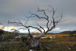
This walk has been on my to do list for a while now. It wasn't until a couple of weeks ago when I was scoping the area out that I discovered the walking track there. It is marked by a small cairn on the side of the road. Going by the registration book not many people know about it either. What a gem of a little walk it is though!! I would highly recommend this walk to anyone who doesn't mind a steep climb.
The walk starts near the gravel car park below Tim Shea (the highest point on the Gordon River Rd) elevation 651 metres and climbs to the summit at 1021 metres. It's about 95kms from Hobart. Walk about 15 metres towards the west to the obvious cairn on the left side of the road. It is pretty much a constant climb from the beginning with the start and the final ascent to the summit being the steepest bits. The track is in good condition, a little overgrown in spots, and goes all the way to the summit. It might be a bit boggy after rain though. I am guessing the track is about 2 kms one way. Took about an hour to the summit stopping for lots of photos.
There are some very interesting rock formations along the way which take your mind off the constant climbing. The view from the top is nothing short of breathtaking. Uninterupted in every direction the whole SW is open before your eyes. Mt Mueller makes an imposing site as does the Mt Field range. Ranges stretch in every direction. The only down point to the view was the burning off by Forestry that was smoking everything up and leaving a thick blue haze on the lower areas.
I didn't spot much wildlife, lot's of grasshoppers and bees with birds chirping through the lower forest section. Saw one Whip Snake about 20 cms in length slither off down the track (in my direction no less!!!).
Photos are here
The Needles - SW National Park
Forum rules
Tasmania specific bushwalking discussion. Please avoid publishing details of access to sensitive areas with no tracks.
Tasmania specific bushwalking discussion. Please avoid publishing details of access to sensitive areas with no tracks.
4 posts
• Page 1 of 1
The Needles - SW National Park
![]() by tasdaz » Wed 12 Mar, 2008 4:14 pm
by tasdaz » Wed 12 Mar, 2008 4:14 pm
Ain't no mountain high enough
Ain't no river deep enough
Too keep from walking in Tassie
Ain't no river deep enough
Too keep from walking in Tassie
-

tasdaz - Nothofagus gunnii

- Posts: 46
- Joined: Tue 01 Jan, 2008 4:10 pm
- Location: Hobart
- Region: Tasmania
Re: The Needles - SW National Park
![]() by tasadam » Fri 14 Mar, 2008 11:55 am
by tasadam » Fri 14 Mar, 2008 11:55 am
Cool!
I got a good look at the Needles on the way out from my Mt Anne walk. looked inspiring.
On the Scotts Peak road - all the way down, there are heaps and heaps of bee hive boxes on the side of the road - Never seen so many. Thaty would explain the bees...
Them white lippoed snakes are dumb beggars aren't they...
-
tasadam - Magnus administratio

- Posts: 5940
- Joined: Tue 10 Apr, 2007 6:58 pm
- Location: Near Devonport, Tasmania
- ASSOCIATED ORGANISATIONS: TasmaniART, Smitten Merino, Macpac
- Region: Tasmania
- Gender: Male
Re: The Needles - SW National Park
![]() by bluewombat » Sun 23 Mar, 2008 3:57 pm
by bluewombat » Sun 23 Mar, 2008 3:57 pm
This is a great little walk, certainly steadily uphill but the grade is not ridiculous and the track is in good condition. The parking area is, as mentioned in tasdaz's post, labelled as the highest point on the Gordon River road and also makes mention of the fact they get 190 cms of rain there each year, it is not too far past the 60kms to Lake Peddar sign. You need to keep your eyes open near the start to make sure you get onto the track proper where it peels off from the initial firetrail/old road part. There is a Parks registration book and box at this junction and there is plenty of pink track tape to make you look towards it (RHS). We took it very easy and still made the top in 70 minutes. The views are spectacular on a clear day, The Thumbs, Mueller, Tim Shea, Field West and Mt Lord are all visible in the foreground and I think I could see as far as the Ironbounds in SW today. Recommended, thanks for bringing it up tasdaz.
bw
bw
Even a long life is short
HPB
HPB
-

bluewombat - Athrotaxis cupressoides

- Posts: 327
- Joined: Sun 10 Feb, 2008 3:55 pm
- Region: Tasmania
Re: The Needles - SW National Park
![]() by tasdaz » Sun 23 Mar, 2008 5:08 pm
by tasdaz » Sun 23 Mar, 2008 5:08 pm
bluewombat wrote:Recommended, thanks for bringing it up tasdaz.
bw
I am glad you liked the walk as much as I did! I had driven past so many times and never knew about the track. They don't make it obvious at all.
Ain't no mountain high enough
Ain't no river deep enough
Too keep from walking in Tassie
Ain't no river deep enough
Too keep from walking in Tassie
-
tasdaz - Nothofagus gunnii
- Posts: 46
- Joined: Tue 01 Jan, 2008 4:10 pm
- Location: Hobart
- Region: Tasmania
4 posts
• Page 1 of 1
Who is online
Users browsing this forum: No registered users and 26 guests