Hi
Does anyone have any info on the best access into Mt Tor?
Hingrock
Mt Tor
Forum rules
Tasmania specific bushwalking discussion. Please avoid publishing details of access to sensitive areas with no tracks.
Tasmania specific bushwalking discussion. Please avoid publishing details of access to sensitive areas with no tracks.
44 posts
• Page 1 of 2 • 1, 2
Re: Mt Tor
![]() by tastrekker » Thu 20 Mar, 2008 11:08 pm
by tastrekker » Thu 20 Mar, 2008 11:08 pm
G'day Hingrock,
The walk up Mt Tor is described on page 11 in "The Abels Volume One".
The best approach is via private property owned by Gunns. Vehicular access may be possible by approaching their Ridgley office. The walk starts at a bridge over the Leven River on Leven Road, 30kms from the Hampshire Gate. I was last there 15 years ago and the bridge was impassable. I avoided the Hampshire gate by riding a pushbike from Upper Natone. I was able to continue cycling over the bridge and up the logging roads on the side of Mt Tor to within 1.5km distance and 350m altitude of the summit. The top road was very overgrown and due to snow, poor visibility and being dressed for cycling rather than scrub bashing, I didn't actually make it up to the summit.
I went back again a few months later and this time cycled in from Loongana via a new road link through to Dempster Creek Road and then on to Leven Road. There is a locked boom gate halfway up the new road. On that trip, I did not continue beyond the Leven River bridge so Mt Tor still remains on my to-do-list.
Given that this walk is featured in "The Abels," I'm sure people must do it from time to time. However, perhaps the access issues put people off.
There is no reserve status protecting the forest on the western slopes of Mt Tor so the day is likely to come when Forestry Tas or Gunns will rebuild the bridge to harvest the timber. Perhaps it has happened already.
-

tastrekker - Athrotaxis cupressoides

- Posts: 498
- Joined: Thu 20 Sep, 2007 9:04 pm
- Location: Lenah Valley
- Region: Tasmania
- Gender: Male
Re: Mt Tor
![]() by corvus » Fri 21 Mar, 2008 5:04 pm
by corvus » Fri 21 Mar, 2008 5:04 pm
Cannot help you on uptodate info but reading tasrekers post reminds me of a 4wheel drive trip 20 years ago towards Mt Tor on the marked tracks to Mt Tor through Loonganna tracks and we (pre GPS )took a wrong turn and spent several hours recovering the lead vehicle "Mine" but the bridge was iffie even then.
Please keep me posted if and when you do this I will mark it to do again on foot if possible
Please keep me posted if and when you do this I will mark it to do again on foot if possible
collige virgo rosas
-

corvus - Vercundus gearus-freakius

- Posts: 5538
- Joined: Mon 23 Apr, 2007 7:24 pm
- Location: Devonport
- Region: Tasmania
- Gender: Male
Re: Mt Tor
![]() by Son of a Beach » Fri 21 Mar, 2008 8:38 pm
by Son of a Beach » Fri 21 Mar, 2008 8:38 pm
Interesting... When I was a young teenager, my father went part shares in a property at Loongana (an informal arrangement) to avoid the property being bought up for forestry uses (although it had already been logged many decades ago, it has since regrown to a great forest again). I used to go camping there occasionally with Dad, and later with mates.
The property is a great bit of land, with mixed eucalyptus and rainforest (and a lot of blackberries in the clear areas). The access to the part of the property that lies on the south side of the road used to be across a creek via a bridge that has been deliberately destroyed to make access more difficult, and so now it is only via fording the creek just downstream from the bridge. Driving along the old track to the Leven river gets you to an old bridge across the Leven (which was the south boundary of the property).
Even then (25 years ago?), I don't think I would have attempted driving a car across this bridge. It was just two HUGE tree trunks with large planks across them. But last time I visited (a couple of years ago) there was very little of the bridge left at all. It was difficult to even walk across.
I've never heard of Mt Tor before now, but looking it up just now, it appears as though if I continued across this old bridge, it would bring me to Mt Tor. I'll have to ask my Dad who it was in his consortium who became the official owner of the property, and if they still own it (I think they threw in $500 each at the time).
Looking at it on Google Earth is really sad. Everything up and down the road from this block as been cleared for forestry. I think I'm going to get a shock next time I visit.
In this picture the "Loongana" placemark (pin) is the turnoff for the private property where I used to camp. You can clearly see the track going south over the Leven toward Mt Tor.
The property is a great bit of land, with mixed eucalyptus and rainforest (and a lot of blackberries in the clear areas). The access to the part of the property that lies on the south side of the road used to be across a creek via a bridge that has been deliberately destroyed to make access more difficult, and so now it is only via fording the creek just downstream from the bridge. Driving along the old track to the Leven river gets you to an old bridge across the Leven (which was the south boundary of the property).
Even then (25 years ago?), I don't think I would have attempted driving a car across this bridge. It was just two HUGE tree trunks with large planks across them. But last time I visited (a couple of years ago) there was very little of the bridge left at all. It was difficult to even walk across.
I've never heard of Mt Tor before now, but looking it up just now, it appears as though if I continued across this old bridge, it would bring me to Mt Tor. I'll have to ask my Dad who it was in his consortium who became the official owner of the property, and if they still own it (I think they threw in $500 each at the time).
Looking at it on Google Earth is really sad. Everything up and down the road from this block as been cleared for forestry. I think I'm going to get a shock next time I visit.
- Loongana.png (130.45 KiB) Viewed 26798 times
In this picture the "Loongana" placemark (pin) is the turnoff for the private property where I used to camp. You can clearly see the track going south over the Leven toward Mt Tor.
- Son of a Beach
- Lagarostrobos franklinii

- Posts: 7024
- Joined: Thu 01 Mar, 2007 7:55 am
- ASSOCIATED ORGANISATIONS: Bit Map (NIXANZ)
- Region: Tasmania
- Gender: Male
Re: Mt Tor
![]() by Speculator » Sun 23 Mar, 2008 10:16 am
by Speculator » Sun 23 Mar, 2008 10:16 am
Hingrock wrote:Hi
Does anyone have any info on the best access into Mt Tor?
Hingrock
Heya Hingrock! Nice to see another former Geocacher over here on these forums. I've often looked at the maps of that area and wondered about Mt. Tor myself. I assumed it was all Forestry/Gunns land and inaccessible as a result, but never really looked into it properly. If it looks possible, I'll add it to my to-do list!
L8r.
---
Peak bagging points: 10. Peak bagging bagging points: 10000.
Peak bagging points: 10. Peak bagging bagging points: 10000.
-

Speculator - Optimus Imago
- Posts: 521
- Joined: Fri 15 Jun, 2007 10:35 pm
- Location: Ulverstone
- Region: Tasmania
Re: Mt Tor
![]() by Son of a Beach » Sun 23 Mar, 2008 7:09 pm
by Son of a Beach » Sun 23 Mar, 2008 7:09 pm
Looking at the maps, it appears there are two ways in to Mt Tor, are you guys (and/or the Abels book) talking about the Ring Road (access from the West of Mt Tor) or the Alps Road (access from the North East, and East of Mt Tor)?
The Alps Road is the one that starts off in the private property I used to camp on. I think I might see if I can get down there on Saturday to have a look. Seems like the main road there is no longer a dead end too. That will be interesting. I wonder if all the alternative lifestyle people still live in that area after all the forestry activity, and the road now going right through.
The Alps Road is the one that starts off in the private property I used to camp on. I think I might see if I can get down there on Saturday to have a look. Seems like the main road there is no longer a dead end too. That will be interesting. I wonder if all the alternative lifestyle people still live in that area after all the forestry activity, and the road now going right through.
- Son of a Beach
- Lagarostrobos franklinii
- Posts: 7024
- Joined: Thu 01 Mar, 2007 7:55 am
- ASSOCIATED ORGANISATIONS: Bit Map (NIXANZ)
- Region: Tasmania
- Gender: Male
Re: Mt Tor
![]() by tastrekker » Mon 24 Mar, 2008 8:10 pm
by tastrekker » Mon 24 Mar, 2008 8:10 pm
Son of a Beach wrote:Looking at the maps, it appears there are two ways in to Mt Tor, are you guys (and/or the Abels book) talking about the Ring Road (access from the West of Mt Tor) or the Alps Road (access from the North East, and East of Mt Tor)?
The Abels describes the route via Ring Road to the west of Mt Tor. The description in the book takes you in from the Gunns gate at Hampshire and then along Guilford, Blythe, Leven and Ring Roads.
Here’s a photo taken from the bridge over the Leven at the foot of Ring Road. The bridge was closed to vehicular traffic at the time which was in 1993. I had ridden in along Blythe Road from the Upper Natone Forest Reserve. There is a locked gate on the Blythe River bridge when you go in this way. I’ve since found you can drive to this gate by taking a road south from near the Upper Natone Road crossing of Wollastonite Creek. The second photo shows Mt Tor from Ring Road.


These next 2 photos are taken from Alps Road at a similar time (circa 1993). I now know that I was (tres)passing through Mr SoB’s little chunk of paradise. The first one shows the bridge that had been removed from Dempster Creek and the large bridge in the other photo is the Alps Road over the Leven.


On the other side of the river, Alps Road was almost completely impassable. I couldn’t drag my bike through the regrowth for more than a few metres before I gave up. It looks like a convenient way to tackle Mt Tor as maps show it climbing all the way up to the saddle between Tor and Black Bluff. However, I expect the road is much too overgrown for this to be any use.
Son of a Beach wrote:The Alps Road is the one that starts off in the private property I used to camp on. I think I might see if I can get down there on Saturday to have a look. Seems like the main road there is no longer a dead end too. That will be interesting. I wonder if all the alternative lifestyle people still live in that area after all the forestry activity, and the road now going right through.
Soon after the link Road from Loongana through to Guilford was put in, I used it to ride from Loongana to Ring Road and back. The new road parallels Maxfields road where there are some interesting and one or two rather stunning houses. In places, the two roads are only a few metres apart. It looked rather tragic though. The ‘post harvest burnoffs’ had just been completed and these houses with their magnificent views of Black Bluff looked terribly forlorn on small islands of green in the middle of a blackened wasteland.
Oops, I think I've strayed off topic a bit. The bottom line is that I still haven't climbed Mt Tor via any route. I look forward to hearing of someone's successful conquest.
-
tastrekker - Athrotaxis cupressoides
- Posts: 498
- Joined: Thu 20 Sep, 2007 9:04 pm
- Location: Lenah Valley
- Region: Tasmania
- Gender: Male
Re: Mt Tor
![]() by Son of a Beach » Tue 25 Mar, 2008 1:03 pm
by Son of a Beach » Tue 25 Mar, 2008 1:03 pm
Nice pics tastrekker. The second two sure do look familiar.
I was thinking of going in this Saturday, but the weather doesn't look too good. I might try again in another two weeks after that, weather and wife permitting. I've bought the map in any case. There's another road that branches off the alps road immediately south of the bridge and scoots all the way west and south to join the ring road. It in turn has another branch which actually gets part way up the northern slopes of Mt Tor, which may be worth a shot. However, the alps road route (in my mind) looks good as it goes right past a small waterfall and a couple of pools, according to the map.
However, as you say, these roads are all long disused, and overgrown, and may not be reliable routes to follow, even on foot, anymore.
Even if I do get as far along the old roads as I wish to, I may find it very difficult to get much further. The map shows everything around Mt Tor as either "low dense vegetation", "scrub" or "medium forest with low dense vegetation".
- Son of a Beach
- Lagarostrobos franklinii
- Posts: 7024
- Joined: Thu 01 Mar, 2007 7:55 am
- ASSOCIATED ORGANISATIONS: Bit Map (NIXANZ)
- Region: Tasmania
- Gender: Male
Re: Mt Tor
![]() by tastrekker » Tue 08 Apr, 2008 8:32 pm
by tastrekker » Tue 08 Apr, 2008 8:32 pm
Yesterday I finally ticked Mt Tor off my peak bagger's list.
I drove in to Loongana and continued along the road to where it ends at a locked gate. It is important to realise that roads in this area have changed dramatically in recent years. Most maps show Loongana Road becoming Alstergren Road and heading north to Loyetea which is south of South Rianna. This road is now closed (according to the sign - someone with a chainsaw and 4WD may prove this wrong). The other development is that Gunns have bought all the blocks of land surrounding this idyllic valley between Black Bluff and the Loongana Range. Rather than take the logs out via the narrow winding tourist road in the vicinity of Leven Canyon, Gunns have built a new road called Loongana Link which hooks up with their private network of roads and gives easier road access to their woodchip mill at Hampshire.
From the locked gate, I rode up Loongana Link, right into North Dempsters Road, left into Dempsters Creek Road and left into Leven Road (un-named at this intersection). After a short ride along Leven Road, it becomes unused as there has been no logging in this part of the Leven Valley itself for many years. The road is still in good condition making for a fun rapid descent to a picnic shelter beside the Leven River, 45 minutes ride from the car.
The bridge decking has been removed so I carefully shouldered my bike and walked over the logs that now span the Leven. As per the instructions in "The Abels," I took the left fork of Ring Road, then a right fork and a final left fork to arrive at the 750m level high on the western flank of Mount Tor. Most of the road is completely overgrown with large bushes but I naively dragged my bike through the saturated shrubbery in the vain hope that there may be some clear riding further up. This took an hour of hard slog which is the same as the time "The Abels" said it would take to walk up these old roads.
After leaving the bike in the bushes on the highest point of the spur road, I followed snig tracks for a while before leaving these and heading on an easterly bearing through relatively open rainforest. One above the tree-line, I arrived at the cliffs and had the choice of some basic rock climbing or sidline around to the south where a broad gully beckoned. I sidled most of the way round but decided to engage the rock as the scrub started getting nasty. After the first band of rock, I was above the thick scrub and shrubs were generally only ankle to knee high.
Very easy walking led around to the eastern side of the summit block and along to the highest point where a small cairn had been assembled. This took just over an hour from when I had left the bike. The view from the top was dominated by Black Bluff to the east and the massive tree farms of the Surrey Hills to the west. The Leven River cuts a deep swathe around Mount Tor as it flows north and then east toward the gaping jaws of Leven Canyon.
On the way down, I opted for the 'open' gully rather than the rocks and found myself bashing through tea tree and baurea for a short way as I skirted around towards the north to regain the rainforested slopes above the spur road. By following a westerly compass bearing, I was relieved to arrive back at my bike with pin-point accuracy.
Having the bike was virtually no advantage in terms of time because it almost took me an hour to bash it back down through the scrub back to the Leven. What I saved in leg effort was lost in arm effort as I braked constantly to avoid my hands, face and shins being shredded by the constant barrage of twigs and branches.
The clear road from the picnic shelter was a relief but the climb out of the Leven valley was quite relentless. Finally I attained the more level ground through the tree farms and an hour after leaving the picnic shelter, I was back at the car.
The moral of this story is that the pushbike was a good way to access the start of the walk at the Leven River but it is definitely not worth taking it any further. By far the easiest way to do this walk would be to ask Gunns for permission to drive to the Leven River picnic shelter.
If you want to see pictures from my walk, check this entry at my blog.
-
tastrekker - Athrotaxis cupressoides
- Posts: 498
- Joined: Thu 20 Sep, 2007 9:04 pm
- Location: Lenah Valley
- Region: Tasmania
- Gender: Male
Re: Mt Tor
![]() by Speculator » Tue 08 Apr, 2008 8:43 pm
by Speculator » Tue 08 Apr, 2008 8:43 pm
Top effort tastrekker!
There's no better answer to a question that someone actually going out and trying it for themselves! Sounds like there was a decent potential to get properly lost on the way up and down the mountain though!
L8r.
There's no better answer to a question that someone actually going out and trying it for themselves!
L8r.
---
Peak bagging points: 10. Peak bagging bagging points: 10000.
Peak bagging points: 10. Peak bagging bagging points: 10000.
-
Speculator - Optimus Imago
- Posts: 521
- Joined: Fri 15 Jun, 2007 10:35 pm
- Location: Ulverstone
- Region: Tasmania
Re: Mt Tor
![]() by tastrekker » Tue 08 Apr, 2008 8:51 pm
by tastrekker » Tue 08 Apr, 2008 8:51 pm
Speculator wrote:Sounds like there was a decent potential to get properly lost
True. Mrs TasTrekker is very glad she was not on this one.
-
tastrekker - Athrotaxis cupressoides
- Posts: 498
- Joined: Thu 20 Sep, 2007 9:04 pm
- Location: Lenah Valley
- Region: Tasmania
- Gender: Male
Re: Mt Tor
![]() by Son of a Beach » Sun 13 Apr, 2008 9:54 am
by Son of a Beach » Sun 13 Apr, 2008 9:54 am
After reading this topic when it first started, I decided that I would have a go at Mt Tor as soon as possible, but from Alps Road, starting at the block of land where I used to camp as a kid. I originally scheduled it for a couple of weeks ago, but the weather was pretty awful. I finally had a go yesterday.
Unfortunately, the weather wasn't too good yesterday either, and it rained on and off all day down there. So I had a late start in the hope that the weather would be better, but I was out of luck. I forded Dempster Creek in the borrowed ute near where the old bridge used to be. Virtually all traces of that bridge are now gone, and the remaining logs that were in TasTrekker's photo...
are now all washed further down the creek.
I parked the ute near the Leven river ford (which was too deep and swift to ford in any normal sized 4wd ute), and waded across. This was a bit scarey, as the water was mid thigh deep, and running very swiftly over large round slippery rocks. If I lost my footing (which I nearly did a couple of times, I would have been swept about 20 metres downstream to where it got slow and deep. The old Leven River bridge just near the ford, as shown is TasTrekker's other photo...
has also disappeared since I was last here, presumably rotted/washed away (hence the wading through the river).
I then proceeded to follow what used to be Alps Road south heading towards the east side of Mt Tor. This road turned out to be now so overgrown that it was exceedingly difficult to follow. Not only because of the tangle of new growth and old fallen trees that I had to scramble through, but also because in many places I couldn't even see where the old track was at all. I frequently had to back track and hunt around for the slightest hints of dual wheel ruts. After about 3/4 of an hour, I could find no further trace of the road, and hadn't really walked very far in terms of distance.
At this point, I gave up on the idea of climbing the mountain, as I realised that I'd either under estimated the scrub, or (more likely) overestimated my ability to do the whole walk solo. I think that with company, I would have had a lot more confidence to push harder and get further. Additionally, in hindsight, I should have just ignored the road and followed the nearby Tor Creek.
In any case, I thought I may as well make something out of the day, having come this far, and got out the map. I could see nothing in any direction except trees, and have no GPS, so I was only going by map and compass. I decided to head down to Tor Creek, and follow it up to find a nice place for lunch, and then follow it all the way back to the Leven River, to make a nice circuit.
So this is what I did. It's a beautiful creek, and I saw a platypus swimming in a large pool created by an enormous log-jam, as well as parrots (rosellas?) in the trees. However, following the creek proved rather difficult, as the trees were very thick (and of course were often thicker nearer the creek). I was surprised to come across many large expanses of Horizontal scrub, which of course is completely impenetrable, and you just have to go around or over the top. I clambered across the top in most cases, including one stand which I used to clamber all the way over the creek at one point.
On the way back, I followed the creek all the way, criss-crossing it frequently to use the side with the less thick scrub, and sometimes just wading along through the middle of it when it was not too deep.
In the end I walked for nearly 4 hours, without getting very far, but I did enjoy my day out. I waited at the car for about an hour until my mate whom I'd left fishing in Dempster Creek returned (he'd caught one).
Mt Tor will have to wait for another day.
Pictures from this walk are now posted in the gallery HERE.
Unfortunately, the weather wasn't too good yesterday either, and it rained on and off all day down there. So I had a late start in the hope that the weather would be better, but I was out of luck. I forded Dempster Creek in the borrowed ute near where the old bridge used to be. Virtually all traces of that bridge are now gone, and the remaining logs that were in TasTrekker's photo...
are now all washed further down the creek.I parked the ute near the Leven river ford (which was too deep and swift to ford in any normal sized 4wd ute), and waded across. This was a bit scarey, as the water was mid thigh deep, and running very swiftly over large round slippery rocks. If I lost my footing (which I nearly did a couple of times, I would have been swept about 20 metres downstream to where it got slow and deep. The old Leven River bridge just near the ford, as shown is TasTrekker's other photo...
has also disappeared since I was last here, presumably rotted/washed away (hence the wading through the river).I then proceeded to follow what used to be Alps Road south heading towards the east side of Mt Tor. This road turned out to be now so overgrown that it was exceedingly difficult to follow. Not only because of the tangle of new growth and old fallen trees that I had to scramble through, but also because in many places I couldn't even see where the old track was at all. I frequently had to back track and hunt around for the slightest hints of dual wheel ruts. After about 3/4 of an hour, I could find no further trace of the road, and hadn't really walked very far in terms of distance.
At this point, I gave up on the idea of climbing the mountain, as I realised that I'd either under estimated the scrub, or (more likely) overestimated my ability to do the whole walk solo. I think that with company, I would have had a lot more confidence to push harder and get further. Additionally, in hindsight, I should have just ignored the road and followed the nearby Tor Creek.
In any case, I thought I may as well make something out of the day, having come this far, and got out the map. I could see nothing in any direction except trees, and have no GPS, so I was only going by map and compass. I decided to head down to Tor Creek, and follow it up to find a nice place for lunch, and then follow it all the way back to the Leven River, to make a nice circuit.
So this is what I did. It's a beautiful creek, and I saw a platypus swimming in a large pool created by an enormous log-jam, as well as parrots (rosellas?) in the trees. However, following the creek proved rather difficult, as the trees were very thick (and of course were often thicker nearer the creek). I was surprised to come across many large expanses of Horizontal scrub, which of course is completely impenetrable, and you just have to go around or over the top. I clambered across the top in most cases, including one stand which I used to clamber all the way over the creek at one point.
On the way back, I followed the creek all the way, criss-crossing it frequently to use the side with the less thick scrub, and sometimes just wading along through the middle of it when it was not too deep.
In the end I walked for nearly 4 hours, without getting very far, but I did enjoy my day out. I waited at the car for about an hour until my mate whom I'd left fishing in Dempster Creek returned (he'd caught one).
Mt Tor will have to wait for another day.
Pictures from this walk are now posted in the gallery HERE.
- Son of a Beach
- Lagarostrobos franklinii
- Posts: 7024
- Joined: Thu 01 Mar, 2007 7:55 am
- ASSOCIATED ORGANISATIONS: Bit Map (NIXANZ)
- Region: Tasmania
- Gender: Male
Re: Mt Tor
![]() by rohjoe » Mon 13 Jun, 2011 10:58 pm
by rohjoe » Mon 13 Jun, 2011 10:58 pm
Yesterday I joined Iluvswtas and MJD on a successful trip to Mt Tor. We approached from the western side, essentially following Tastrekker's route (minus the bike ride!  ). The Blythe Rd gate seems to have been left open for some weeks (I went through at Easter to climb Mt Everett).
We parked about 1 km from the old Leven Rd bridge as a few trees have fallen across the road at that point. After the road walk we found a very straightforward route up to a gully leading to the summit, with negligible scrub. Total walk time was about 4.5 hours. It's definitely the sort of peak worth going back to, so it's unfortunate that access is a bit iffy.
Regards,
Rohan
Cradle & Barn
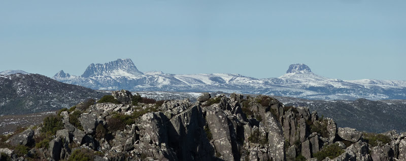
Black Bluff
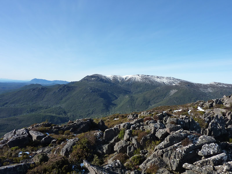
Looking towards St Valentines Peak

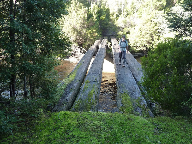
Leven River Bridge
Old Picnic Shelter

We parked about 1 km from the old Leven Rd bridge as a few trees have fallen across the road at that point. After the road walk we found a very straightforward route up to a gully leading to the summit, with negligible scrub. Total walk time was about 4.5 hours. It's definitely the sort of peak worth going back to, so it's unfortunate that access is a bit iffy.
Regards,
Rohan
Cradle & Barn
Black Bluff
Looking towards St Valentines Peak
Leven River Bridge
Old Picnic Shelter
-

rohjoe - Athrotaxis cupressoides
- Posts: 107
- Joined: Fri 04 Jan, 2008 8:40 pm
- Region: Tasmania
Re: Mt Tor
![]() by ILUVSWTAS » Tue 14 Jun, 2011 6:33 am
by ILUVSWTAS » Tue 14 Jun, 2011 6:33 am
Nice work Rohjoe!! I must say climbing this peak was much much easier than expected. The scrub just didnt seem to hit us, we must have picked an excellent route.
I love the photo of me crossing the bridge, I look alot more comfortable than I actually was, the logs were quite icy and a tad slippery, and the river below looked deep and cold.
Awesome photo of Cradle and Barn btw.
I love the photo of me crossing the bridge, I look alot more comfortable than I actually was, the logs were quite icy and a tad slippery, and the river below looked deep and cold.
Awesome photo of Cradle and Barn btw.
- Attachments
-
- Tor.JPG (73.04 KiB) Viewed 26098 times
Nothing to see here.
-
ILUVSWTAS - Lagarostrobos franklinii
- Posts: 11046
- Joined: Sun 28 Dec, 2008 9:53 am
- Region: Tasmania
- Gender: Male
Re: Mt Tor
![]() by tastrekker » Tue 14 Jun, 2011 10:47 am
by tastrekker » Tue 14 Jun, 2011 10:47 am
Well done team. Sounds/looks like you had a ripper walk. It was gorgeous weekend so I expect there were plenty of people out there making the most of it. I worked in our Melbourne office Sun/Mon so didn't get into the bush.
I gather you picked a route that took you straight to the base of the cliffs and then found a climbable gully. I aimed slightly to the south to avoid the cliffs. Sounds like I should have gone more direct!
I gather you picked a route that took you straight to the base of the cliffs and then found a climbable gully. I aimed slightly to the south to avoid the cliffs. Sounds like I should have gone more direct!
-
tastrekker - Athrotaxis cupressoides
- Posts: 498
- Joined: Thu 20 Sep, 2007 9:04 pm
- Location: Lenah Valley
- Region: Tasmania
- Gender: Male
Re: Mt Tor
![]() by ILUVSWTAS » Tue 14 Jun, 2011 10:53 am
by ILUVSWTAS » Tue 14 Jun, 2011 10:53 am
Yes we went directly at it, there was a very easy gully inbetween the cliffs, it was pleasantly surprising. We had your notes thanks very much!!
The roads have now been upgraded up until about 1k before the picnic shelter where it's quite rough and lots of fallen trees. It must have been a huge ride on your bike from where you came in from!!
It was a gorgeous weekend, we saw 3 other groups on Black Bluff, everyone was making the most of the snow in beautiful conditions!!
Nothing to see here.
-
ILUVSWTAS - Lagarostrobos franklinii
- Posts: 11046
- Joined: Sun 28 Dec, 2008 9:53 am
- Region: Tasmania
- Gender: Male
Re: Mt Tor
![]() by MJD » Tue 14 Jun, 2011 8:00 pm
by MJD » Tue 14 Jun, 2011 8:00 pm
I aimed slightly to the south to avoid the cliffs.
Too much planning for us
Certainly a walk worth doing, and hopefully the gate will stay open.
Carpe diem
-

MJD - Athrotaxis selaginoides

- Posts: 1023
- Joined: Mon 26 May, 2008 11:24 pm
- Region: Tasmania
Re: Mt Tor
![]() by taswegian » Tue 14 Jun, 2011 8:50 pm
by taswegian » Tue 14 Jun, 2011 8:50 pm
beaut part of the world and equally great views - thanks.
My wife laughed when she saw that picnic shelter.
Last time she was there she was very rotund and the road very rough and she wondered if we would get home with one extra in the ute
Did you blokes make it up and home in a day?
Hell of a long one if you did. Assuming down south is your home.
My wife laughed when she saw that picnic shelter.
Last time she was there she was very rotund and the road very rough and she wondered if we would get home with one extra in the ute
Did you blokes make it up and home in a day?
Hell of a long one if you did. Assuming down south is your home.
-
taswegian - Phyllocladus aspleniifolius

- Posts: 888
- Joined: Tue 27 Jul, 2010 8:34 pm
- Region: Tasmania
- Gender: Male
Re: Mt Tor
![]() by rohjoe » Tue 14 Jun, 2011 9:32 pm
by rohjoe » Tue 14 Jun, 2011 9:32 pm
Did you blokes make it up and home in a day?
No, thankfully such an epic journey was not required - this was part of a multi-day peak bagging jaunt. I was based at an Ulverstone caravan park enjoying the luxury of a hot shower each night while ILUVSWTAS and MJD did it the hard way, camping nearby in the forestry plantations. The frosts were pretty hard apparently!
Glad to hear that bub waited until you got home!
-
rohjoe - Athrotaxis cupressoides
- Posts: 107
- Joined: Fri 04 Jan, 2008 8:40 pm
- Region: Tasmania
Re: Mt Tor
![]() by MJD » Tue 14 Jun, 2011 11:50 pm
by MJD » Tue 14 Jun, 2011 11:50 pm
Three nice days but two cold nights. It was -5C on Monday morning, and we were only at 600m.
Carpe diem
-
MJD - Athrotaxis selaginoides
- Posts: 1023
- Joined: Mon 26 May, 2008 11:24 pm
- Region: Tasmania
Re: Mt Tor
![]() by ILUVSWTAS » Wed 15 Jun, 2011 7:45 am
by ILUVSWTAS » Wed 15 Jun, 2011 7:45 am
MJD wrote:Three nice days but two cold nights. It was -5C on Monday morning, and we were only at 600m.
and there were still patches of snow sitting in the shady parts of the forsestry roads at this height!!
Nothing to see here.
-
ILUVSWTAS - Lagarostrobos franklinii
- Posts: 11046
- Joined: Sun 28 Dec, 2008 9:53 am
- Region: Tasmania
- Gender: Male
Re: Mt Tor
![]() by north-north-west » Sun 19 Jun, 2011 2:59 pm
by north-north-west » Sun 19 Jun, 2011 2:59 pm
Wow! *Adds another one to the 'must do' list for the next visit . . .
. . . *sigh* . . . so many mountains, so little time left . . .
. . . *sigh* . . . so many mountains, so little time left . . .
"Mit der Dummheit kämpfen Götter selbst vergebens."
-

north-north-west - Lagarostrobos franklinii
- Posts: 15134
- Joined: Thu 14 May, 2009 7:36 pm
- Location: The Asylum
- ASSOCIATED ORGANISATIONS: Social Misfits Anonymous
- Region: Tasmania
Re: Mt Tor
![]() by stu » Tue 02 Dec, 2014 3:02 pm
by stu » Tue 02 Dec, 2014 3:02 pm
Anyone have any recent info on accessing Mount Tor?
Many thanks in advance
Many thanks in advance
-

stu - Lagarostrobos franklinii
- Posts: 2174
- Joined: Fri 02 May, 2008 8:31 am
- Region: Tasmania
Re: Mt Tor
![]() by north-north-west » Wed 03 Dec, 2014 7:40 am
by north-north-west » Wed 03 Dec, 2014 7:40 am
Far as I know the Blythe Rd is now permanently gated so the old route is no longer an option. The route described in the second Abels book still holds good, far as I know, though I did it last summer. There's no bridge and the river crossing can be difficult if there's been rain - but it drops pretty quickly.
What he says about keeping to the left at the start of the climb once you leave the forestry tracks is very important - start curling up to the right too soon and you'll hit some awkward stuff. On the other hand, going too far around before you turn up will also land you in the gunge. The westerly line in this is the way I went up - pads and pretty easy going. The descent line was not a good idea.
What he says about keeping to the left at the start of the climb once you leave the forestry tracks is very important - start curling up to the right too soon and you'll hit some awkward stuff. On the other hand, going too far around before you turn up will also land you in the gunge. The westerly line in this is the way I went up - pads and pretty easy going. The descent line was not a good idea.
"Mit der Dummheit kämpfen Götter selbst vergebens."
-
north-north-west - Lagarostrobos franklinii
- Posts: 15134
- Joined: Thu 14 May, 2009 7:36 pm
- Location: The Asylum
- ASSOCIATED ORGANISATIONS: Social Misfits Anonymous
- Region: Tasmania
Re: Mt Tor
![]() by ILUVSWTAS » Wed 03 Dec, 2014 7:46 am
by ILUVSWTAS » Wed 03 Dec, 2014 7:46 am
That's a real shame about the Blythe road. Access to a few peaks in that area will now be very difficult.
The old approach to Tor was such a nice walk, is the bridge the issue regarding the Blythe road? Or are they logging the area?
The old approach to Tor was such a nice walk, is the bridge the issue regarding the Blythe road? Or are they logging the area?
Nothing to see here.
-
ILUVSWTAS - Lagarostrobos franklinii
- Posts: 11046
- Joined: Sun 28 Dec, 2008 9:53 am
- Region: Tasmania
- Gender: Male
Re: Mt Tor
![]() by north-north-west » Wed 03 Dec, 2014 7:52 am
by north-north-west » Wed 03 Dec, 2014 7:52 am
Logging and mining I think. As far as I know the log trucks still use the road.
It's the same reason the access to St Valentines has been changed.
It's the same reason the access to St Valentines has been changed.
"Mit der Dummheit kämpfen Götter selbst vergebens."
-
north-north-west - Lagarostrobos franklinii
- Posts: 15134
- Joined: Thu 14 May, 2009 7:36 pm
- Location: The Asylum
- ASSOCIATED ORGANISATIONS: Social Misfits Anonymous
- Region: Tasmania
Re: Mt Tor
![]() by saley » Sun 22 Mar, 2015 2:40 pm
by saley » Sun 22 Mar, 2015 2:40 pm
Son of a Beach wrote:Nice pics tastrekker. The second two sure do look familiar.
I was thinking of going in this Saturday, but the weather doesn't look too good. I might try again in another two weeks after that, weather and wife permitting. I've bought the map in any case. There's another road that branches off the alps road immediately south of the bridge and scoots all the way west and south to join the ring road. It in turn has another branch which actually gets part way up the northern slopes of Mt Tor, which may be worth a shot. However, the alps road route (in my mind) looks good as it goes right past a small waterfall and a couple of pools, according to the map.
However, as you say, these roads are all long disused, and overgrown, and may not be reliable routes to follow, even on foot, anymore.
Even if I do get as far along the old roads as I wish to, I may find it very difficult to get much further. The map shows everything around Mt Tor as either "low dense vegetation", "scrub" or "medium forest with low dense vegetation".
Came across this rather dated post recently after looking for info re the Alps Road. I am one of the co-owners referred to in the post. The old bridge is long gone sadly, but a track has been cut on the west side of Alps Rd and goes to a ford. There is a ramp visible on the other side. Fairly clear, suggesting 4WDs have been though here - perhaps when the water was a little lower.
- saley
- Nothofagus cunninghamii

- Posts: 1
- Joined: Sun 22 Mar, 2015 2:17 pm
- Region: Tasmania
- Gender: Male
Re: Mt Tor
![]() by Taurë-rana » Mon 13 Apr, 2015 11:16 pm
by Taurë-rana » Mon 13 Apr, 2015 11:16 pm
Blythe Rd was open some time last year, maybe last summer? I went in from the Upper Natone Forest Reserve and drove to the old picnic shelter. I was also told that the road from the west end through to Loongana was open as well. Must go for a drive and check it all out.
I went up Mt Tor the same route as rohjoe, ILUV and MJD a few years ago. There were traces of tape and cairns where I went up, and it was reasonably easy. I have walked right round the Ring Road too.
I went up Mt Tor the same route as rohjoe, ILUV and MJD a few years ago. There were traces of tape and cairns where I went up, and it was reasonably easy. I have walked right round the Ring Road too.
Peak bagging points: 170ish
Recent walks - Picton, Wylds Crag, Rogoona
Recent walks - Picton, Wylds Crag, Rogoona
-

Taurë-rana - Athrotaxis selaginoides
- Posts: 1031
- Joined: Mon 14 Jan, 2008 8:28 pm
- Location: Devonport
- Region: Tasmania
Re: Mt Tor
![]() by Crawfinator » Wed 29 Aug, 2018 9:43 am
by Crawfinator » Wed 29 Aug, 2018 9:43 am
Just wondering if anyone had any more recent information on access to Mt Tor?
Suggestions at how close i can drive before hitting a locked gate.
Am happy to take a bike to road bash if necessary rather than spend time collecting keys etc.
Suggestions at how close i can drive before hitting a locked gate.
Am happy to take a bike to road bash if necessary rather than spend time collecting keys etc.
- Crawfinator
- Nothofagus gunnii

- Posts: 26
- Joined: Wed 24 Aug, 2016 9:22 pm
- Region: Tasmania
- Gender: Male
Re: Mt Tor
![]() by north-north-west » Wed 29 Aug, 2018 12:00 pm
by north-north-west » Wed 29 Aug, 2018 12:00 pm
As far as I know, the shortest access is from Loongana Rd, as per the Abels books (Vol I). River crossing, vehicle tracks for a bit, then up an old lead (turn off was cairned when I did it) and into the buttongrass.
"Mit der Dummheit kämpfen Götter selbst vergebens."
-
north-north-west - Lagarostrobos franklinii
- Posts: 15134
- Joined: Thu 14 May, 2009 7:36 pm
- Location: The Asylum
- ASSOCIATED ORGANISATIONS: Social Misfits Anonymous
- Region: Tasmania
44 posts
• Page 1 of 2 • 1, 2