I have been aware of the Moonlight Ridge Trackfor some time and have decided its time to 'knock it off'. I dont know much about it and have been unable to track down any detailed information about, track conditions, water availability, terrain etc etc. I am not 100% sure of the start point and how many days it takes to do it. Can anyone out there who knows about the track or who may have recently traveresed the track provide me with any information that might be useful.
I am experienced with Tasmanian walks (South Coast Track, Overland Track, Frenchmans track etc).
Appreciate any information
MOONLIGHT RIDGE TRACK
Forum rules
Posting large/multiple images in this forum is OK. Please start topic titles with the name of the location or track.
For topics focussed on photos rather than the trip, please consider posting in the 'Gallery' forum instead.
This forum is for posting information about trips you have done, not for requesting information about a track or area.
39 posts
• Page 1 of 2 • 1, 2
MOONLIGHT RIDGE TRACK
![]() by Roger » Sat 13 Dec, 2014 7:10 pm
by Roger » Sat 13 Dec, 2014 7:10 pm
- Roger
- Nothofagus gunnii

- Posts: 31
- Joined: Thu 30 Jul, 2009 3:44 pm
- Region: Tasmania
Re: MOONLIGHT RIDGE TRACK
![]() by norts » Sat 13 Dec, 2014 7:31 pm
by norts » Sat 13 Dec, 2014 7:31 pm
I suggest you get Chapmans South West book. Moonlight Ridge is part of the track to Pindars Peak. It starts near Ida Bay and goes through to Pindars Peak and then onto PB. Chapman call it the Southern Ranges. Great walk all the way through to Prion Beach and then return on the SCT.
Roger/Norts
Roger/Norts
-
norts - Lagarostrobos franklinii

- Posts: 2013
- Joined: Wed 01 Aug, 2007 10:45 am
- Location: Germantown Tas.
- Region: Tasmania
Re: MOONLIGHT RIDGE TRACK
![]() by Ally-pop » Sun 14 Dec, 2014 1:48 pm
by Ally-pop » Sun 14 Dec, 2014 1:48 pm
I walked to Moonlight Ridge in October. Norts is correct, if you get Chapmans SW book it has the all the info in it.
The start of the track is simple to find, turn right into South Lune Road just past the Ida Bay Railway. About 5 kms down turn left towards an old quarry. You cannot miss the start of the track as there is a walkers registration booth visible from the road.
The beginning of the track is shared with the walk to Mystery Creek cave but once your reach the old quarry the track is signed to the caves or the southern range.
It is relatively steep in a few sections and apart from the creek that you cross at the very beginning of the walk there is no water until Bullfrog tarns.
The track is quite well taped through the forest only a couple of places where you may need to stop and have a look around.
Moonlight ridge itself is very open after the fires went through but it is still easy to find the track. If you continue further the only place it is a little confusing is around the crossing of Moonlight Creek as it is really boggy. If you head in the general direction you have been travelling you should come across so wooden posts with arrows on the other side of the creek.
It could easily be done as a day walk but if you have the time (and the weather) it is a great overnighter.
Happy walking!
Last edited by Ally-pop on Sun 14 Dec, 2014 3:42 pm, edited 1 time in total.
- Ally-pop
- Nothofagus gunnii
- Posts: 20
- Joined: Tue 22 Apr, 2014 7:16 pm
- Location: Far South Tas
- Region: Tasmania
- Gender: Female
Re: MOONLIGHT RIDGE TRACK
![]() by sherpa » Sun 14 Dec, 2014 3:36 pm
by sherpa » Sun 14 Dec, 2014 3:36 pm
Hi Roger,
Yes its a great walk, definitely worth spending some time up there. If not doing the circuit round the SCT then at least spend a night
up there. Take your time and take it all in. Make sure both you and your tent can stand up to the wind.
If you put Southern Ranges into the search function I think there should be a few trip reports and pics etc.
S
- sherpa
- Atherosperma moschatum

- Posts: 91
- Joined: Sun 15 Apr, 2012 4:05 pm
- Region: Tasmania
- Gender: Male
- Ally-pop
- Nothofagus gunnii
- Posts: 20
- Joined: Tue 22 Apr, 2014 7:16 pm
- Location: Far South Tas
- Region: Tasmania
- Gender: Female
Re: MOONLIGHT RIDGE TRACK
![]() by MickyB » Sun 14 Dec, 2014 4:27 pm
by MickyB » Sun 14 Dec, 2014 4:27 pm
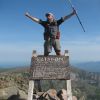
For comparison here is a photo from before the fires (Jan 2012)
- Attachments
-
Sometimes, I use big words I don't always fully understand in an effort to make myself sound more photosynthesis.
-

MickyB - Auctorita modica

- Posts: 1426
- Joined: Thu 28 Jun, 2012 7:50 pm
- Region: Victoria
- Gender: Male
Re: MOONLIGHT RIDGE TRACK
![]() by GraemeSpedding » Mon 22 Dec, 2014 3:01 pm
by GraemeSpedding » Mon 22 Dec, 2014 3:01 pm
Roger wrote:I have been aware of the Moonlight Ridge Trackfor some time and have decided its time to 'knock it off'. I dont know much about it and have been unable to track down any detailed information about, track conditions, water availability, terrain etc etc. I am not 100% sure of the start point and how many days it takes to do it. Can anyone out there who knows about the track or who may have recently traveresed the track provide me with any information that might be useful.
I am experienced with Tasmanian walks (South Coast Track, Overland Track, Frenchmans track etc).
Appreciate any information
Hi Roger, i have walked the whole PB Circuit a few times in the last 5 years. Moonlight Ridge is pretty straightforward, except where it crosses the creek below Hill One. Good camping next to the lake at pig sty ponds. Allow a few days for bad Wx. Not much water beyond the above mentioned creek until Pig sty ponds. well worth doing the trips up to Pindars etc. If you can get used to the Scoparia the entire circuit is a great challenge and lots of fun in good wx.
Good luck.
"Dare your genius to walk the Wild Uncharted Way" B. Courtney
-
GraemeSpedding - Atherosperma moschatum
- Posts: 66
- Joined: Thu 19 Mar, 2009 2:00 pm
- Location: Perth WA
- Region: Western Australia
- Gender: Male
Re: MOONLIGHT RIDGE TRACK
![]() by TheGhostWhoWalks » Thu 12 Mar, 2015 4:50 pm
by TheGhostWhoWalks » Thu 12 Mar, 2015 4:50 pm
Just down from a shortened trip due to crap weather. The fires have destroyed any camping potential near the top of moonlight creek, the ground is very boggy and there is no shelter from wind. The burnt sticks created lots of trip hazards. Pigsty ponds would be ambitious as a day walk.
- TheGhostWhoWalks
- Nothofagus gunnii
- Posts: 20
- Joined: Sat 15 Nov, 2014 3:53 pm
- Location: Fingal valley or Hobart region.
- Region: Tasmania
- Gender: Male
Re: MOONLIGHT RIDGE TRACK
![]() by pazzar » Mon 30 Mar, 2015 6:36 pm
by pazzar » Mon 30 Mar, 2015 6:36 pm
With the burnt section, the trick is to follow the bog. It is much easier walking through it now as the bog is avoidable, and the pads are obvious. It gets a little vague around Moonlight Creek, but the markers are there to follow if you keep your eyes open. Not good camping at the creek as the water course has changes with the fire. I would expect most groups to take around 8 hours to get to Pigsty Ponds, which is lovely camping.
"It's not what you look at that matters, it's what you see."
-
pazzar - Lagarostrobos franklinii
- Posts: 2743
- Joined: Thu 09 Jul, 2009 5:22 pm
- Location: Hobart
- Region: Tasmania
- Gender: Male
Re: MOONLIGHT RIDGE TRACK
![]() by Thornbill » Tue 12 Jan, 2016 2:05 pm
by Thornbill » Tue 12 Jan, 2016 2:05 pm
TheGhostWhoWalks wrote:The fires have destroyed any camping potential near the top of moonlight creek, the ground is very boggy and there is no shelter from wind.
G'day folks. Thinking of heading up to poke around the Southern Ranges for a couple of days (3 days, 2 nights probably) next month. Has anyone been up that way and can update on the state of camping at Moonlight Creek? I understand it used to be ok, but no so after a fire >12 months ago? Thinking it might be better to get an early start and push on to Pigsty Ponds instead. TIA
How would a cubist paint a flounder?
-

Thornbill - Athrotaxis cupressoides

- Posts: 230
- Joined: Tue 25 Mar, 2014 2:25 pm
- Location: Hobart
- Region: Tasmania
- Gender: Male
Re: MOONLIGHT RIDGE TRACK
![]() by eggs » Tue 12 Jan, 2016 3:14 pm
by eggs » Tue 12 Jan, 2016 3:14 pm
Since the Moonlight Creek campsite is burnt out, there were a few campsites cut into the scrub a fair way up on the initial ascent.
It is on a slight benched area before the last climb up onto the ridge proper at about the 560m mark.
If you need to break up the trip, you could camp there, but you would have to carry sufficient water on the first day.
This is the only shot I had of the spot.
It is on a slight benched area before the last climb up onto the ridge proper at about the 560m mark.
If you need to break up the trip, you could camp there, but you would have to carry sufficient water on the first day.
This is the only shot I had of the spot.
- Spot on the track with some campsites cut into the scrub.
-
eggs - Lagarostrobos franklinii
- Posts: 10469
- Joined: Fri 23 May, 2008 2:58 pm
- Location: Para Vista, South Australia
- Region: South Australia
Re: MOONLIGHT RIDGE TRACK
![]() by stepbystep » Tue 12 Jan, 2016 3:30 pm
by stepbystep » Tue 12 Jan, 2016 3:30 pm
Thornbill wrote:TheGhostWhoWalks wrote:The fires have destroyed any camping potential near the top of moonlight creek, the ground is very boggy and there is no shelter from wind.
G'day folks. Thinking of heading up to poke around the Southern Ranges for a couple of days (3 days, 2 nights probably) next month. Has anyone been up that way and can update on the state of camping at Moonlight Creek? I understand it used to be ok, but no so after a fire >12 months ago? Thinking it might be better to get an early start and push on to Pigsty Ponds instead. TIA
I was up there end of November, did the full circuit. The campsite Eggs mentions is great if you make a late start. If you get away early you should push on to Pigsty. If you aren't able to, there is crappy camping at Moonlight Creek. I went through in extremely windy conditions and by the creek was the best spot between the forest and Pigsty. Pigsty was also uninviting when we were there, in that case you can descend to the Reservoir Lakes which has excellent, sheltered camping. Moores Bridge is another option, but pretty exposed.
The idea of wilderness needs no defense, it only needs defenders ~ Edward Abbey
-

stepbystep - Lagarostrobos franklinii
- Posts: 7707
- Joined: Tue 19 May, 2009 10:19 am
- Location: Street urchin
- Region: Tasmania
- Gender: Male
Re: MOONLIGHT RIDGE TRACK
![]() by Thornbill » Tue 12 Jan, 2016 5:15 pm
by Thornbill » Tue 12 Jan, 2016 5:15 pm
Cheers for the info folks. I reckon an early start to make Pigsty Ponds is the go. Just need a nice friendly high to prop over the state for a few days 
How would a cubist paint a flounder?
-
Thornbill - Athrotaxis cupressoides
- Posts: 230
- Joined: Tue 25 Mar, 2014 2:25 pm
- Location: Hobart
- Region: Tasmania
- Gender: Male
Re: MOONLIGHT RIDGE TRACK
![]() by north-north-west » Tue 12 Jan, 2016 7:07 pm
by north-north-west » Tue 12 Jan, 2016 7:07 pm
When I went through I got water from the pools on Hill One, and camped on the saddle between 1 and 2. It was damper overall than currently though, so that might not work. There'd be water at Moore's, wouldn't there?
"Mit der Dummheit kämpfen Götter selbst vergebens."
-

north-north-west - Lagarostrobos franklinii
- Posts: 15145
- Joined: Thu 14 May, 2009 7:36 pm
- Location: The Asylum
- ASSOCIATED ORGANISATIONS: Social Misfits Anonymous
- Region: Tasmania
Re: MOONLIGHT RIDGE TRACK
![]() by stepbystep » Wed 13 Jan, 2016 8:32 am
by stepbystep » Wed 13 Jan, 2016 8:32 am
north-north-west wrote:When I went through I got water from the pools on Hill One, and camped on the saddle between 1 and 2. It was damper overall than currently though, so that might not work. There'd be water at Moore's, wouldn't there?
Moores bridge would probably be dry but over the hill at the garden there will be water. That's a specific sidetrip, a very sensitive area and it's just as quick to go through to Pigsty. The tarn on Hill one had plenty of water when we went through
The idea of wilderness needs no defense, it only needs defenders ~ Edward Abbey
-
stepbystep - Lagarostrobos franklinii
- Posts: 7707
- Joined: Tue 19 May, 2009 10:19 am
- Location: Street urchin
- Region: Tasmania
- Gender: Male
Re: MOONLIGHT RIDGE TRACK
![]() by Tortoise » Mon 12 Sep, 2016 1:43 pm
by Tortoise » Mon 12 Sep, 2016 1:43 pm
Reviving this thread as I hope to have my first foray into the area soon. Have I missed any road or track closures that would affect access? (I'll keep an eye on the snow.) Ta for any info.
-

Tortoise - Lagarostrobos franklinii
- Posts: 5166
- Joined: Sat 28 Jan, 2012 9:31 pm
- Location: NW Tasmania
- Region: Tasmania
- Gender: Female
Re: MOONLIGHT RIDGE TRACK
![]() by devoswitch » Tue 13 Sep, 2016 5:48 am
by devoswitch » Tue 13 Sep, 2016 5:48 am
Hi Tortoise, I'm very jealous! I've never been up on the southern ranges. It's definitely high on my list to do!
I'd be very surprised if there were any road closures as its only a couple of km of the main drag to the track head by memory when I went to the mystery creek cave. It's a must see as its only another 20 or so minutes into your trip!
I'd be very surprised if there were any road closures as its only a couple of km of the main drag to the track head by memory when I went to the mystery creek cave. It's a must see as its only another 20 or so minutes into your trip!
-
devoswitch - Athrotaxis cupressoides
- Posts: 424
- Joined: Mon 30 Dec, 2013 5:36 pm
- Region: Tasmania
- Gender: Male
Re: MOONLIGHT RIDGE TRACK
![]() by Tortoise » Tue 13 Sep, 2016 8:37 am
by Tortoise » Tue 13 Sep, 2016 8:37 am
devoswitch wrote:Hi Tortoise, I'm very jealous! I've never been up on the southern ranges. It's definitely high on my list to do!
I'd be very surprised if there were any road closures as its only a couple of km of the main drag to the track head by memory when I went to the mystery creek cave. It's a must see as its only another 20 or so minutes into your trip!
Thanks, Devoswitch. It's been rising on my list for a long time!
I'm probably a bit paranoid because of the huge amount of damage done by the floods up north, that is preventing access to huge areas. And the websites that list closures are not always reliable.
I'll look into Mystery Creek Cave too. I have great memories of a cave near Lune River, on my second trip to Tassie umm a few decades ago. Stayed at the youth hostel, where the kind folks equipped us with helmets and head torches (before they'd been invented for bushwalkers) and 'turn left at the big tree' type of instructions to a cave with zillions of glow worms.
-
Tortoise - Lagarostrobos franklinii
- Posts: 5166
- Joined: Sat 28 Jan, 2012 9:31 pm
- Location: NW Tasmania
- Region: Tasmania
- Gender: Female
Re: MOONLIGHT RIDGE TRACK
![]() by devoswitch » Tue 13 Sep, 2016 12:29 pm
by devoswitch » Tue 13 Sep, 2016 12:29 pm
Yeah the cave is wonderful! Albeit very creepy! Not a place you would want to be when there's a bit of water around!
Are you doing the full circuit or just poppin up there o explore for a while?
Are you doing the full circuit or just poppin up there o explore for a while?
-
devoswitch - Athrotaxis cupressoides
- Posts: 424
- Joined: Mon 30 Dec, 2013 5:36 pm
- Region: Tasmania
- Gender: Male
Re: MOONLIGHT RIDGE TRACK
![]() by pazzar » Thu 27 Oct, 2016 9:55 am
by pazzar » Thu 27 Oct, 2016 9:55 am
stepbystep wrote:north-north-west wrote:When I went through I got water from the pools on Hill One, and camped on the saddle between 1 and 2. It was damper overall than currently though, so that might not work. There'd be water at Moore's, wouldn't there?
Moores bridge would probably be dry but over the hill at the garden there will be water. That's a specific sidetrip, a very sensitive area and it's just as quick to go through to Pigsty. The tarn on Hill one had plenty of water when we went through
For anyone that needs an emergency camp, there are several tarns on Moores Bridge, so water is very reliable here. Some shelter amongst the king billy's just below the climb up to Moores Garden. I camped here after battling through winds that I could barely stand in, the respite was very welcome. It is only another hour or so to Pigsty, so I would recommend pushing on to there if possible.
"It's not what you look at that matters, it's what you see."
-
pazzar - Lagarostrobos franklinii
- Posts: 2743
- Joined: Thu 09 Jul, 2009 5:22 pm
- Location: Hobart
- Region: Tasmania
- Gender: Male
Re: MOONLIGHT RIDGE TRACK
![]() by TheOmen » Fri 01 Nov, 2019 10:28 am
by TheOmen » Fri 01 Nov, 2019 10:28 am
Hi All,
A brief summary of a recent trip, adding this to the old topic to ensure that all information is contained in one spot.
Day 1
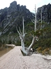
The walk overview image generally what we encountered over the course of the walk. The very start of the track is all flat until you get to the Mystery Cave sign. This was where we spotted the first snake, warming up on the loose gravel remanent of the mine. It’s not long after the sign that you start the steep climbing through the forest, the track briefly levels out which is a nice spot for a breather as you meander through a few different ecotones and step over some decent sized fallen trees, footholds included. This is probably the last remaining spot to camp, if you wanted a sheltered spot but doesn’t get you far if you’re going to Pigsty Ponds.
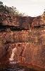
Another similar climb gets you up to the plateau and into the remnants of the early 2012 bushfire damaged scrub (from reading other posts). The track here starts to give way, due in part to the fire's destruction of scrub and also the flat topography of this section, leading to various meandering tracks throughout with no clear single track. You come across a few Tarns here which in the later October, after a dry winter, still held enough water to refill if needed. The path generally gets worse and worse until you get to what we affectionately called Maximum Bog around where the Moonlight Creek would flow, no doubt due to the creek, which was running at the time. This section generally is slow going given the bog but makes for easy walking given the previous uphill. Most of the path here is indistinguishable with multiple boggy paths all heading in the generally similar direction, if you are lucky enough you might spot a few wooden posts with arrows pointing in the right direction, many of them are charred or missing arrows.
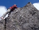
By this stage, it’s probably only another hour of trekking before you hit what is the last uphill section on your way to camp. This is also where the bush bashing begins or more rhythmically the bush push, by which I mean you while you have a definitive track it’s overgrown and you’ve got to push through. Small sections of steps and boardwalks litter through this section before you find yourself on at the top, which glorious views to the East and the extent of the bushfire damage.
From the summit of Hill 1, it’s relatively easy hiking as you’ve done the bulk of the vertical gradient along with the track being rocky and simple. There are a couple more Tarns here, some were empty others held a little, and in the peak of summer, I’d think they would be dry.
The track undulates around the remaining Hills before you get a glimpse of Pigsty Pond. A few interesting spots along the way reintroduce you to bog and bush bashing but nothing by now you aren’t well versed in.
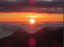
Getting on top of Hill 3 you start to get views of the Mt Perouse and Pindars Peak in the distance, weather dependent, along with the first glimpse of Pigsty Ponds, giving you your final destination in sight.
The gentle decline takes you into Pigsty Ponds where the choice of the campsite is largely dependent on the wind condition and the following day’s activities. There were a few spots to camp near the end of the track with clearly visible white rocks, providing relatively flat and dry camping. We met a few fellow hikers and they showed us where they were camping near Reservoir Lakes, another 15min walk away. We decided to pitch down there as it was arguably the best spot and the wind was forecast to pick up to nearly 100km/h where Maxwell Ridge, we thought, would provide the greatest shelter from the Westerly.
Day 2
The following day we’d planned to hit up Pindars Peak and Mt Perouse. We began the journey from Pigsty Ponds up to the junction towards Pindars, only to find the delayed wind had picked up and while we weren’t on a ridgeline yet we decided against going any further, given how windy and wild it had become.
Thus the remainder of the day was spent at camp reading and relaxing. The spot near Reservoir Lakes amongst the trees was excellent, the wind howled yet we barely felt the tent move.
We had heard that the other hikers that they’d done Pindars and Perouse the previous day, saying it took them 10 hours to do scale both and the closer you got to Pindars the thicker the bush bashing became.
Day 3
The third day gave us better luck. The wind had died down significantly and we tried out luck with Mount Perouse before returning to the car. The journey up is relatively straight forward the only hairy part is the junction to Mt Perouse. There aren’t any clearly marked signs saying Pindars or Perouse the only thing to guide you, which we missed the first time, is a mound of rocks depicting a junction stacked on the ground, keep your eyes peeled. Once heading in the right direction it’s easy-going, follow the rock mounds and a gentle constant incline.
The return and subsequent trek back to the car was just a retrace. This time easier and quicker given the lack of gradient change came at the end rather than the start.
General
Echoing others 2 days seems like the bare minimum for Pigsty Ponds, 1 day in, 1 day out. While we managed to get up to Perouse and back out in “2” walking days, we had taken a break day in between given the weather and needed a day to recover after the trek up and back on the last day.
Giving yourself 3 days allows for some adventuring beyond and further afield, along with enjoying the place.
While I’m sure the fittest of us could go to Pindars and back in 1 day, you’d probably take another day to recover.
A brief summary of a recent trip, adding this to the old topic to ensure that all information is contained in one spot.
- Moonlight Ridge Track - Walk Overview
Day 1
The walk overview image generally what we encountered over the course of the walk. The very start of the track is all flat until you get to the Mystery Cave sign. This was where we spotted the first snake, warming up on the loose gravel remanent of the mine. It’s not long after the sign that you start the steep climbing through the forest, the track briefly levels out which is a nice spot for a breather as you meander through a few different ecotones and step over some decent sized fallen trees, footholds included. This is probably the last remaining spot to camp, if you wanted a sheltered spot but doesn’t get you far if you’re going to Pigsty Ponds.
Another similar climb gets you up to the plateau and into the remnants of the early 2012 bushfire damaged scrub (from reading other posts). The track here starts to give way, due in part to the fire's destruction of scrub and also the flat topography of this section, leading to various meandering tracks throughout with no clear single track. You come across a few Tarns here which in the later October, after a dry winter, still held enough water to refill if needed. The path generally gets worse and worse until you get to what we affectionately called Maximum Bog around where the Moonlight Creek would flow, no doubt due to the creek, which was running at the time. This section generally is slow going given the bog but makes for easy walking given the previous uphill. Most of the path here is indistinguishable with multiple boggy paths all heading in the generally similar direction, if you are lucky enough you might spot a few wooden posts with arrows pointing in the right direction, many of them are charred or missing arrows.
- Moonlight Ridge Track - lesser bog
By this stage, it’s probably only another hour of trekking before you hit what is the last uphill section on your way to camp. This is also where the bush bashing begins or more rhythmically the bush push, by which I mean you while you have a definitive track it’s overgrown and you’ve got to push through. Small sections of steps and boardwalks litter through this section before you find yourself on at the top, which glorious views to the East and the extent of the bushfire damage.
- Moonlight Ridge Track - halfway up Hill 1 clearly showing extent of fire damage
From the summit of Hill 1, it’s relatively easy hiking as you’ve done the bulk of the vertical gradient along with the track being rocky and simple. There are a couple more Tarns here, some were empty others held a little, and in the peak of summer, I’d think they would be dry.
- Moonlight Ridge Track - looking towards Hill 2
- Moonlight Ridge Track - Fan out
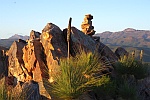
The track undulates around the remaining Hills before you get a glimpse of Pigsty Pond. A few interesting spots along the way reintroduce you to bog and bush bashing but nothing by now you aren’t well versed in.
Getting on top of Hill 3 you start to get views of the Mt Perouse and Pindars Peak in the distance, weather dependent, along with the first glimpse of Pigsty Ponds, giving you your final destination in sight.
- Moonlight Ridge Track - Mount Perouse
The gentle decline takes you into Pigsty Ponds where the choice of the campsite is largely dependent on the wind condition and the following day’s activities. There were a few spots to camp near the end of the track with clearly visible white rocks, providing relatively flat and dry camping. We met a few fellow hikers and they showed us where they were camping near Reservoir Lakes, another 15min walk away. We decided to pitch down there as it was arguably the best spot and the wind was forecast to pick up to nearly 100km/h where Maxwell Ridge, we thought, would provide the greatest shelter from the Westerly.
Day 2
The following day we’d planned to hit up Pindars Peak and Mt Perouse. We began the journey from Pigsty Ponds up to the junction towards Pindars, only to find the delayed wind had picked up and while we weren’t on a ridgeline yet we decided against going any further, given how windy and wild it had become.
Thus the remainder of the day was spent at camp reading and relaxing. The spot near Reservoir Lakes amongst the trees was excellent, the wind howled yet we barely felt the tent move.
We had heard that the other hikers that they’d done Pindars and Perouse the previous day, saying it took them 10 hours to do scale both and the closer you got to Pindars the thicker the bush bashing became.
Day 3
The third day gave us better luck. The wind had died down significantly and we tried out luck with Mount Perouse before returning to the car. The journey up is relatively straight forward the only hairy part is the junction to Mt Perouse. There aren’t any clearly marked signs saying Pindars or Perouse the only thing to guide you, which we missed the first time, is a mound of rocks depicting a junction stacked on the ground, keep your eyes peeled. Once heading in the right direction it’s easy-going, follow the rock mounds and a gentle constant incline.
The return and subsequent trek back to the car was just a retrace. This time easier and quicker given the lack of gradient change came at the end rather than the start.
- Moonlight Ridge Track - Mount Perouse Views, looking south
General
Echoing others 2 days seems like the bare minimum for Pigsty Ponds, 1 day in, 1 day out. While we managed to get up to Perouse and back out in “2” walking days, we had taken a break day in between given the weather and needed a day to recover after the trek up and back on the last day.
Giving yourself 3 days allows for some adventuring beyond and further afield, along with enjoying the place.
While I’m sure the fittest of us could go to Pindars and back in 1 day, you’d probably take another day to recover.
- TheOmen
- Nothofagus gunnii
- Posts: 30
- Joined: Mon 09 Jun, 2008 8:41 pm
- Region: Tasmania
Re: MOONLIGHT RIDGE TRACK
![]() by north-north-west » Fri 01 Nov, 2019 12:16 pm
by north-north-west » Fri 01 Nov, 2019 12:16 pm
La Perouse. It's on your map, just not particularly clear.
The junction used to be marked with a large multi-pronged arrow constructed from rocks. Is that no longer there?
The junction used to be marked with a large multi-pronged arrow constructed from rocks. Is that no longer there?
"Mit der Dummheit kämpfen Götter selbst vergebens."
-
north-north-west - Lagarostrobos franklinii
- Posts: 15145
- Joined: Thu 14 May, 2009 7:36 pm
- Location: The Asylum
- ASSOCIATED ORGANISATIONS: Social Misfits Anonymous
- Region: Tasmania
Re: MOONLIGHT RIDGE TRACK
![]() by L_Cham_67 » Fri 01 Nov, 2019 12:27 pm
by L_Cham_67 » Fri 01 Nov, 2019 12:27 pm
north-north-west wrote:
The junction used to be marked with a large multi-pronged arrow constructed from rocks. Is that no longer there?
It was there in March...
& It's interesting those other hikers said the scrub gets thicker closer to Pindars Peak. I remember it being quite open between Ooze Lake and Pindars. Descending Maxwell Ridge was a bit tricky though with scrub and a rutted track (plus the terrible weather haha). Perhaps that's what they were referring to.
-
L_Cham_67 - Athrotaxis selaginoides

- Posts: 1045
- Joined: Thu 17 Dec, 2015 6:43 pm
- Region: Tasmania
- Gender: Male
Re: MOONLIGHT RIDGE TRACK
![]() by north-north-west » Fri 01 Nov, 2019 1:15 pm
by north-north-west » Fri 01 Nov, 2019 1:15 pm
L_Cham_67 wrote:& It's interesting those other hikers said the scrub gets thicker closer to Pindars Peak. I remember it being quite open between Ooze Lake and Pindars. Descending Maxwell Ridge was a bit tricky though with scrub and a rutted track (plus the terrible weather haha). Perhaps that's what they were referring to.
It is very open once you leave Ooze, as I well remember after twice walking it in foul weather.
"Mit der Dummheit kämpfen Götter selbst vergebens."
-
north-north-west - Lagarostrobos franklinii
- Posts: 15145
- Joined: Thu 14 May, 2009 7:36 pm
- Location: The Asylum
- ASSOCIATED ORGANISATIONS: Social Misfits Anonymous
- Region: Tasmania
Re: MOONLIGHT RIDGE TRACK
![]() by TheOmen » Fri 01 Nov, 2019 1:35 pm
by TheOmen » Fri 01 Nov, 2019 1:35 pm
L_Cham_67 wrote:north-north-west wrote:
The junction used to be marked with a large multi-pronged arrow constructed from rocks. Is that no longer there?
It was there in March...
& It's interesting those other hikers said the scrub gets thicker closer to Pindars Peak. I remember it being quite open between Ooze Lake and Pindars. Descending Maxwell Ridge was a bit tricky though with scrub and a rutted track (plus the terrible weather haha). Perhaps that's what they were referring to.
Yup that's the one, still there as of end of Oct. I was too bush following the cans to take too much notice of it. Hence had to backtrack.
- TheOmen
- Nothofagus gunnii
- Posts: 30
- Joined: Mon 09 Jun, 2008 8:41 pm
- Region: Tasmania
Re: MOONLIGHT RIDGE TRACK
![]() by Alex fraser » Mon 02 Dec, 2019 11:59 pm
by Alex fraser » Mon 02 Dec, 2019 11:59 pm
north-north-west wrote:La Perouse. It's on your map, just not particularly clear.
The junction used to be marked with a large multi-pronged arrow constructed from rocks. Is that no longer there?
It’s still there, atop the small ridge from pigsty, I was there 05 nov, anything plus of the arrow towards pinders was too overgrown/completely gone and without a detailed map and gps we had no hope. Decided to summit la Perouse and hang out at res lakes for the night before the (unpredicted snow) set in and we high tailed it back to the car park... 10hr hike out hill one was knee deep snow. Cairns goooooone! But arrow is definitely still there
- Alex fraser
- Nothofagus cunninghamii

- Posts: 2
- Joined: Mon 02 Dec, 2019 11:41 pm
- Region: Tasmania
- Gender: Male
Re: MOONLIGHT RIDGE TRACK
![]() by DonQx » Fri 06 Dec, 2019 3:50 pm
by DonQx » Fri 06 Dec, 2019 3:50 pm
eggs wrote:Since the Moonlight Creek campsite is burnt out, there were a few campsites cut into the scrub a fair way up on the initial ascent.
It is on a slight benched area before the last climb up onto the ridge proper at about the 560m mark.
If you need to break up the trip, you could camp there, but you would have to carry sufficient water on the first day.
This is the only shot I had of the spot.
Hello everyone,
Seeking advice ...
How many tents could you fit in here for a nite, at a pinch?
Can't get enough of cruisy-paced overnite outdoor trips
Trip philosophy at www.ahack.org
Loc close to Hobart
Trip philosophy at www.ahack.org
Loc close to Hobart
-

DonQx - Athrotaxis cupressoides
- Posts: 362
- Joined: Sun 29 Apr, 2007 5:32 am
- Location: Land of Oz / Taz / Hobart
- Region: Tasmania
- Gender: Male
Re: MOONLIGHT RIDGE TRACK
![]() by ILUVSWTAS » Sat 07 Dec, 2019 6:40 am
by ILUVSWTAS » Sat 07 Dec, 2019 6:40 am
DonQx wrote:eggs wrote:Since the Moonlight Creek campsite is burnt out, there were a few campsites cut into the scrub a fair way up on the initial ascent.
It is on a slight benched area before the last climb up onto the ridge proper at about the 560m mark.
If you need to break up the trip, you could camp there, but you would have to carry sufficient water on the first day.
This is the only shot I had of the spot.
Hello everyone,
Seeking advice ...
How many tents could you fit in here for a nite, at a pinch?
2 larger ones, or if you were desperate you might squeeze 3 or 4 small ones in on top of each other.
Nothing to see here.
-

ILUVSWTAS - Lagarostrobos franklinii
- Posts: 11046
- Joined: Sun 28 Dec, 2008 9:53 am
- Region: Tasmania
- Gender: Male
Re: MOONLIGHT RIDGE TRACK
![]() by DonQx » Sat 07 Dec, 2019 6:45 am
by DonQx » Sat 07 Dec, 2019 6:45 am
Thx for that, appreciated
dq.
dq.
Can't get enough of cruisy-paced overnite outdoor trips
Trip philosophy at www.ahack.org
Loc close to Hobart
Trip philosophy at www.ahack.org
Loc close to Hobart
-
DonQx - Athrotaxis cupressoides
- Posts: 362
- Joined: Sun 29 Apr, 2007 5:32 am
- Location: Land of Oz / Taz / Hobart
- Region: Tasmania
- Gender: Male
Re: MOONLIGHT RIDGE TRACK
![]() by Alex fraser » Wed 11 Dec, 2019 10:56 pm
by Alex fraser » Wed 11 Dec, 2019 10:56 pm
DQ, depends on how wet the area is, I passed that first campsite cut into the scrub (early November 19) and there would be no way I’d camp there... there’s so many different tracks leading to hill 1 we didn’t even see bullfrog tarns until our return trip (obviously not the route we took in) from the car park/sign in hut we hiked straight to pigsty ponds, zero cover and extremely open to the elements after the fires took the bushes and trees. Took about 8 or so hrs to pigsty (felt a lot longer) from the car park. Take the extra 25-30min hike to res lakes for a much more sheltered and comfortable sleep, have fun with the little creek crossing! Good base for la perouse or the falls. Take care and prep for snow!
- Alex fraser
- Nothofagus cunninghamii
- Posts: 2
- Joined: Mon 02 Dec, 2019 11:41 pm
- Region: Tasmania
- Gender: Male
39 posts
• Page 1 of 2 • 1, 2
Return to TAS Trip Reports & Track Notes
Who is online
Users browsing this forum: No registered users and 11 guests