Ironstone Hut & Forty Lakes Peak
Forum rules
Tasmania specific bushwalking discussion. Please avoid publishing details of access to sensitive areas with no tracks.
Tasmania specific bushwalking discussion. Please avoid publishing details of access to sensitive areas with no tracks.
14 posts
• Page 1 of 1
Ironstone Hut & Forty Lakes Peak
![]() by absolom » Mon 04 Feb, 2008 6:10 pm
by absolom » Mon 04 Feb, 2008 6:10 pm
I am looking to walk into Ironstone Hut & also Forty Lakes Peak, & am looking for any info on Higgs track & Syds track, including approx times & also road access into these tracks.
- absolom
- Nothofagus cunninghamii

- Posts: 1
- Joined: Sun 03 Feb, 2008 9:46 pm
Re: Ironstone Hut & Forty Lakes Peak
![]() by Joe » Mon 04 Feb, 2008 7:10 pm
by Joe » Mon 04 Feb, 2008 7:10 pm
viewtopic.php?f=9&t=45&p=160&hilit=higgs+track#p160
photos here.
There is a fair bit of info here already on the area...dont be afraid to use the search feature.
The road into the start of higgs track is (or was less than 3 months ago) perfectly fine in a 2wd (done it in civic, lazer and a falcon over years) and there is a good amount of space to leave your car.
Depending on fitness allow between 3/4 to 1 1/2 to reach Lady Lake. Its uphill whole way from carpark with the last bit being steepest. On top its about 2 hours solid walk into Nameless. Ive only ever made it as far as lucy long and weston, its all flat and dead easy to follow.
-

Joe - in vino veritas

- Posts: 675
- Joined: Mon 26 Mar, 2007 10:35 pm
- Location: Devonport Tas
- ASSOCIATED ORGANISATIONS: Stoney Creek Outdoor Equipment.
- Region: Tasmania
Re: Ironstone Hut & Forty Lakes Peak
![]() by Pompom » Mon 04 Feb, 2008 7:38 pm
by Pompom » Mon 04 Feb, 2008 7:38 pm
Hey Absolom, I reckon the Syds Track to be by far the best to get to the top of the tiers but, for a fisherman such as myself it goes nowhere. It is ideal for Mother Cummings and Bastion Bluff and Ironstone or so I believe. I went up there about 10years ago there was a 2 wheel drive access road that climbed up a fair height, the actual track took about 30 minutes to climb. the last time up the access road had been blocked out by Forestry[I presume] and the walk up the old road was a right nuisance[much like the modified!!! track up Staggs Creek in the Meander Forest.
If you are familiar with the Westrope Road,then you simply travel along it until you hit the turn off for the Westons Track, then carry on past for a short while about 1 1/2 Ks according to Google Earth.The entrance is[was] hard to see I parked my bus at the bottom and walked the rest.Go up the road until you hit a right turn, take this up a short pinch to the end.I hope that the signpost is still there,if not face the tiers and the track start is on your left hand side.
If you have Google Earth plot in the following 41 40 39 s 146 29 42 e and the track start is dead centre, if you zoom in a bit the road names appear and the Higgs and Westons Tracks are well marked.I have a shot of the Google Earth map but I don't know how to stick it in this post. Hope this helps, feel free to critique the above as my memory has been known to wander sometimes.
- Pompom
Re: Ironstone Hut & Forty Lakes Peak
![]() by Son of a Beach » Mon 04 Feb, 2008 8:18 pm
by Son of a Beach » Mon 04 Feb, 2008 8:18 pm
As taswaterfalls said, there's a lot of info on this area already in the forums. Eg, the following forums search turns up a wealth of results: (higgs|lady|nameless|ironstone)
My only experience here is with Higgs Track, Lady Lake, to Lake Nameless and Forty Lakes Peak. The other information others have provided here is pretty much right, except that I would say that Higgs Track has a couple of areas where it becomes a little indistinct, but not hard to follow, so long as the weather is good. It doesn't take much snow for it to become invisible (and it can snow at any time of year, of course), and then it's a game of find the cairn, or use your navigation skills (in an area where the iron content of the rock makes compasses less useful than in other areas).
My only experience here is with Higgs Track, Lady Lake, to Lake Nameless and Forty Lakes Peak. The other information others have provided here is pretty much right, except that I would say that Higgs Track has a couple of areas where it becomes a little indistinct, but not hard to follow, so long as the weather is good. It doesn't take much snow for it to become invisible (and it can snow at any time of year, of course), and then it's a game of find the cairn, or use your navigation skills (in an area where the iron content of the rock makes compasses less useful than in other areas).
- Son of a Beach
- Lagarostrobos franklinii

- Posts: 7024
- Joined: Thu 01 Mar, 2007 7:55 am
- ASSOCIATED ORGANISATIONS: Bit Map (NIXANZ)
- Region: Tasmania
- Gender: Male
Re: Ironstone Hut & Forty Lakes Peak
![]() by Penguin » Mon 04 Feb, 2008 9:18 pm
by Penguin » Mon 04 Feb, 2008 9:18 pm
A mate of mine recently went up Syds track and his comment was that Higgs is a better walk, particularly is you are not familiar with the area. One of the advatages of the Higgs track is that when you get up to the top you have lots of options of where to go next with plenty of easy camping, and a great hut at Lady Lake if not full. You would get to Ironstone in four to five hours without pushing hard from the base of Higgs track.
With PomPoms advice, we avoided the area past Lady Lake in late winter last year - the weather can be foul and very cold.
With PomPoms advice, we avoided the area past Lady Lake in late winter last year - the weather can be foul and very cold.
-

Penguin - Phyllocladus aspleniifolius

- Posts: 775
- Joined: Sun 15 Jul, 2007 9:47 pm
Re: Ironstone Hut & Forty Lakes Peak
![]() by Pompom » Mon 04 Feb, 2008 9:44 pm
by Pompom » Mon 04 Feb, 2008 9:44 pm
If I might add another option and that is the easiest walk by far is from Lake McKenzie via Lake Explorer. The track is easy to follow and just as easy to return on in inclement weather. The crossing of the fish river is only a problem when the lake is pretty full and that's a rarity in summer,even then with a good walking staff it only means wet feet. The track follows the left hand side of Explorer Creek up to when the creek seems bigger and flatter with largish pools, one then walks down to the creek and crosses where possible. A track is then found that follows the right hand side of the creek then up along the lake with an obvious route to the hut via Snake Lake to Lake Nameless where the hut can be sighted with initial difficulty amongst the rocks under the 40 Lakes Peak. I strongly advise against staying on the left hand side of Explorer as the track winds around and through horrible rocks roots and all sorts of stumbly rubbish.
Cheers
Pompom
Cheers
Pompom
- Pompom
Re: Ironstone Hut & Forty Lakes Peak
![]() by Dick » Wed 06 Feb, 2008 5:01 pm
by Dick » Wed 06 Feb, 2008 5:01 pm
absolom wrote:I am looking to walk into Ironstone Hut & also Forty Lakes Peak, & am looking for any info on Higgs track & Syds track, including approx times & also road access into these tracks.
I am confused, I have read the forum and conducted a search but still do not know where Lady lake and Higgs track exactly is, or how to get there, can some one please help me out on this, I am new to Tasmania, which road do you take and where is the nearest town .
- Dick
- Nothofagus cunninghamii
- Posts: 3
- Joined: Sun 03 Feb, 2008 4:11 pm
Re: Ironstone Hut & Forty Lakes Peak
![]() by Joe » Wed 06 Feb, 2008 5:52 pm
by Joe » Wed 06 Feb, 2008 5:52 pm
Park car at s41* 40.048 e146*28.188 which is the start of higgs track. The track is well marked.
access to higgs is via westrope rd near western creek. It depends which way you are coming but i find quickest way from launceston is to turn off into deloirain and head out that way. From Devonport end turn off just after the antiques place at Christmas Hills onto c163 road (Bengeo road i believe) and follow this (staying on bengeo not taking the dunorlan turn off) all the way to red hills. Turn left at red hills t junction then your next left onto what i believe is called the western creek road...or maybe dairy plains road...cant remember. according to my map its c168. Follow this till you hit another T intersection. Turn right and then take your first left onto westropes.
Hope that helps
-
Joe - in vino veritas
- Posts: 675
- Joined: Mon 26 Mar, 2007 10:35 pm
- Location: Devonport Tas
- ASSOCIATED ORGANISATIONS: Stoney Creek Outdoor Equipment.
- Region: Tasmania
Re: Ironstone Hut & Forty Lakes Peak
![]() by Son of a Beach » Wed 06 Feb, 2008 8:28 pm
by Son of a Beach » Wed 06 Feb, 2008 8:28 pm
Dick wrote:I am confused, I have read the forum and conducted a search but still do not know where Lady lake and Higgs track exactly is, or how to get there, can some one please help me out on this, I am new to Tasmania, which road do you take and where is the nearest town .
Good question. TW description is pretty good. I don't have the maps nearby at the moment, but... here's my very vague description...
Coming from Launceston, turn off towards Mole Creek, just after Deloraine (ie, through the western end of Deloraine). Then turn off towards Western Creek & Dairy Plains a somewhat before Chudleigh, then follow this until you come across a dirt road heading off towards the tiers with brown wooden national parks looking signs (can't remember if there's any other turn offs before this?), then follow the signs to Westrope Road, then to Higgs Track. TW directions are then similar to Westrope road, and Higgs track.
Lady Lake Hut is right near the edge of the Western Tiers, where Higgs track reaches the top of the steep bit (which is the entire first hour, or thereabouts). The attached Google Earth placemark shows Lady Lake hut, and if you turn on the Roads option, it will even show Higgs track (it's the only line that passes right past Lady Lake hut.
- Attachments
-
 Lady Lake Hut.kmz
- Google Earth placemark file for Lady Lake hut
- (662 Bytes) Downloaded 529 times
- Son of a Beach
- Lagarostrobos franklinii
- Posts: 7024
- Joined: Thu 01 Mar, 2007 7:55 am
- ASSOCIATED ORGANISATIONS: Bit Map (NIXANZ)
- Region: Tasmania
- Gender: Male
Re: Ironstone Hut & Forty Lakes Peak
![]() by tastrekker » Fri 08 Feb, 2008 6:56 am
by tastrekker » Fri 08 Feb, 2008 6:56 am
Dick wrote:I am confused, I have read the forum and conducted a search but still do not know where Lady lake and Higgs track exactly is, or how to get there, can some one please help me out on this, I am new to Tasmania, which road do you take and where is the nearest town .
If you want to know the whereabouts of any location in Tassie, TheLIST is a good source. (Land Information System Tasmania). Check out LISTMap at http://www.thelist.tas.gov.au/listmap/listmapstart.jsp Click on the Tourism Button, enter the Place Name and click Search. Select the location from the list (if there's more than one) and a map will appear. Depending upon the size of the feature you select, the map may be zoomed in to a point where it's impossible to see where in Tassie you are. If that's the case, use the zoom out tool (magnifying glass with minus sign).
Another great resource is whereis.com. "Suburb or town" is compulsory which is tricky for bush locations but you can get around this. I just put "Westrope Road, Hobart" into whereis and it came up with "westrope road, Western Creek" - bingo! I even tried an obscure road like "Little Fisher Road, Hobart" and it came up with "Little Fisher Road, Mersey Forest." You can then get directions from wherever.
Back to the tracks off Westrope Road, there are 5! In order as you head up the gravel road, they are:
* Higgs Track - The lowest road, starting at 750m above seal level. This is the best marked and most well used of the tracks.
* Western Creek Track - This starts from a carpark at the 850 metre level and essentially follows the valley of Western Creek to the plateau. At one point, it crosses a ledge halfway up a waterfall. (Have you been there taswaterfalls.com?) This track ends at Whiteleys Hut which is beside a clearing NW of Mt Ironstone. Not near any lakes or streams though.
* Lees Track - This starts from the Western Creek Track carpark. Instead of heading towards the creek, this track is a slightly shorter route as it heads directly uphill, joining the Western Creek Track beside a scree slope before you reach the waterfall. Not very well used and may be tricky to find.
* Syds Track - Definitely the shortest route onto the platea as the carpark is around 950m. Last time I walked this one (10 years ago), we had to walk the last 500 metres due to a large log over the track. Small cars were able to proceed as they could fit under the log! This is the track described in "The Abels" book as the way to Mount Ironstone although Western Creek/Lees Track would be a shorter route.
* Mother Cummings Peak (North) Track - This is the furthest track along Westrope Road and it climbs straight up the pointy northern peak of Mother Cummings. However, if you want to climb the highest part of Mother Cummings, this is on the long flat bluff further south and is accessed either from Scotts Road or Smoko Road via Meander.
-

tastrekker - Athrotaxis cupressoides

- Posts: 498
- Joined: Thu 20 Sep, 2007 9:04 pm
- Location: Lenah Valley
- Region: Tasmania
- Gender: Male
Re: Ironstone Hut & Forty Lakes Peak
![]() by Son of a Beach » Fri 08 Feb, 2008 7:32 am
by Son of a Beach » Fri 08 Feb, 2008 7:32 am
tastrekker wrote:Back to the tracks off Westrope Road, there are 5! In order as you head up the gravel road, they are:
* Higgs Track - The lowest road, starting at 750m above seal level. This is the best marked and most well used of the tracks.
* Western Creek Track - This starts from a carpark at the 850 metre level and essentially follows the valley of Western Creek to the plateau. At one point, it crosses a ledge halfway up a waterfall. (Have you been there taswaterfalls.com?) This track ends at Whiteleys Hut which is beside a clearing NW of Mt Ironstone. Not near any lakes or streams though.
* Lees Track - This starts from the Western Creek Track carpark. Instead of heading towards the creek, this track is a slightly shorter route as it heads directly uphill, joining the Western Creek Track beside a scree slope before you reach the waterfall. Not very well used and may be tricky to find.
* Syds Track - Definitely the shortest route onto the platea as the carpark is around 950m. Last time I walked this one (10 years ago), we had to walk the last 500 metres due to a large log over the track. Small cars were able to proceed as they could fit under the log! This is the track described in "The Abels" book as the way to Mount Ironstone although Western Creek/Lees Track would be a shorter route.
* Mother Cummings Peak (North) Track - This is the furthest track along Westrope Road and it climbs straight up the pointy northern peak of Mother Cummings. However, if you want to climb the highest part of Mother Cummings, this is on the long flat bluff further south and is accessed either from Scotts Road or Smoko Road via Meander.
Hey, thanks heaps for this clarification, tastrekker. I've used two of these tracks, but have always been confused about which is which, and had not yet got around to seriously looking into it. You've now saved me the trouble, and it will now be much easier for me to decide on how I use various routes up into that area.
- Son of a Beach
- Lagarostrobos franklinii
- Posts: 7024
- Joined: Thu 01 Mar, 2007 7:55 am
- ASSOCIATED ORGANISATIONS: Bit Map (NIXANZ)
- Region: Tasmania
- Gender: Male
Re: Ironstone Hut & Forty Lakes Peak
![]() by Pompom » Sun 10 Feb, 2008 10:23 am
by Pompom » Sun 10 Feb, 2008 10:23 am
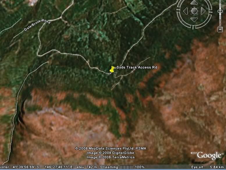
Hi All, Here's a shot from Google Earth showing the Syds Track location.The squiggly road leading to the Syds marker is the Westrope Rd coming from "The Dale Brook Rd"?, the other squiggly one to the left is the WestonsTrack and the one to the far left just above the Dalebrook writing is the Higgs Track. I would point out that I am not sure that what is called the Dalebrook Road as shown is in fact that road or the Westrope Road. I suspect it is the latter and the Dalebrook road is the sealed road that the Westrope comes off.The white squiggly line above the marker is the forestry road that used to be passable by 2 wheeled drive vehicles, the right hand turn leads to the track start as mentioned in my previous post.Hope this helps.
- Pompom
Re: Ironstone Hut & Forty Lakes Peak
![]() by tastrekker » Sun 10 Feb, 2008 8:44 pm
by tastrekker » Sun 10 Feb, 2008 8:44 pm
Dale Brook Road is marked correctly on the Google Earth image. The sealed road at the bottom of Westrope Road is Western Creek Road (C166). Dale Brook Road is the short access track to the Higgs Track.
There's some potential confusion here with the so-called 'Westons Track.' The one on this Google Earth image is actually the Western Creek Track. There is a Westons Rivulet (not creek) but this is much further along the Tiers near Poatina. There is a Westons Road. This is a gated road/track that runs along the top of the Tiers east of Drys Bluff to access weirs on Brumbys Creek and Westons Rivulet. These weirs divert water along a canal south to the Great Lake. It's an alternate 'flat' bushwalking route to Drys Bluff if you can score a key from the Hydro.
There's some potential confusion here with the so-called 'Westons Track.' The one on this Google Earth image is actually the Western Creek Track. There is a Westons Rivulet (not creek) but this is much further along the Tiers near Poatina. There is a Westons Road. This is a gated road/track that runs along the top of the Tiers east of Drys Bluff to access weirs on Brumbys Creek and Westons Rivulet. These weirs divert water along a canal south to the Great Lake. It's an alternate 'flat' bushwalking route to Drys Bluff if you can score a key from the Hydro.
-
tastrekker - Athrotaxis cupressoides
- Posts: 498
- Joined: Thu 20 Sep, 2007 9:04 pm
- Location: Lenah Valley
- Region: Tasmania
- Gender: Male
Re: Ironstone Hut & Forty Lakes Peak
![]() by Dick » Sun 17 Feb, 2008 7:19 pm
by Dick » Sun 17 Feb, 2008 7:19 pm
taswaterfalls.com wrote:Park car at s41* 40.048 e146*28.188 which is the start of higgs track. The track is well marked.
access to higgs is via westrope rd near western creek. It depends which way you are coming but i find quickest way from launceston is to turn off into deloirain and head out that way. From Devonport end turn off just after the antiques place at Christmas Hills onto c163 road (Bengeo road i believe) and follow this (staying on bengeo not taking the dunorlan turn off) all the way to red hills. Turn left at red hills t junction then your next left onto what i believe is called the western creek road...or maybe dairy plains road...cant remember. according to my map its c168. Follow this till you hit another T intersection. Turn right and then take your first left onto westropes.
Hope that helps
Thank you to all, the description on how to get to Higgs track is quite clear, I look forward to heading up north soon, to do some walks.
Dick
- Dick
- Nothofagus cunninghamii
- Posts: 3
- Joined: Sun 03 Feb, 2008 4:11 pm
14 posts
• Page 1 of 1
Who is online
Users browsing this forum: No registered users and 88 guests