Access:
We drove in via West Picton Road - this has a single gate on it but it is unlikely to be locked as there is an emergency meeting point further down the road. Turned right onto West Picton Road Spur 1, and then right again onto Spur 1-2. This spur road was a bit washed out. Clearance was okay but a car with a low range gears would have made crawling up a bit easier - my clutch was quite smelly!

Carpark:
We parked the car here and walked the remainder of the hill.

The Track: (A post here says it starts at 469730E, 5217620N)
The track leaves on the right from where the road takes a left turn and starts to level out. It follows an old snig track through plenty of cutting grass. There are pink tape markers but it is easy enough to follow.
The cutting grass and snig track end and the track gets steeper as it leaves the coup. The track is well marked for the rest of this forest section with pink tap and yellow tags. There are numerous fallen trees/branches/etc which you have to clamber over/under. Towards the top of this section the vegetation gets a bit slimy until you leave the dense forest and the track levels out a bit. It took us approximately 2:30 to reach here.
The track then enters into a scrubby section. Again it is easy enough to follow, however it was also quite a deep creek and the waist high scrub makes it difficult to avoid. Once the track gains a bit more elevation it dries out a little and the scrub thins out. From the top of the ridge in front you get good views to the South Picton Range.


From here to Square Tarn the going is easier. The track heads for the next ridge-line but the pad thins out and the pink tape markers can be harder to find. We started the walk at about 9:30 and arrived at Square Tarn at around 3:30. This was a fair bit longer than we expected. My girlfriend who is less experienced in over-night walks found it quite tough.
Campsite:
As indicated by Wello here there are limited 'good' spots at Square Tarn. It was difficult to find anywhere that wasn't lumpy or very wet! We ended up setting up on the western side of the Tarn.

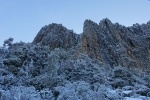
The night was quite chilly - fortunately we both had sleeping bags able to cope with sub-zero temps. We awoke to find our wet boots, gaiters, etc. and our water bottles had frozen solid!

We had a late start and headed off back down the track at about 10:30. Found the going quicker on the way back. Stopped for lunch on the ridge-line before the scrub band at about 12:00. We made it back to the car for about 2:30 and cautiously tackled the washed out road again.
Summary:
Great views, however we spent more time trying to avoid the creeks/bog than enjoying the scenery. I would do this walk again (and head out to Burgess Bluff or Mt Chapman) but only at the end of summer once everything had a chance to dry out!