Forum rules
Please keep the width of embedded images (using [img] [/img] tags) in this forum to no more than 800 pixels wide (this will avoid them being clipped without notice by most users' window sizes). Attached images can be any resolution so long as the file size is no more than 1 MB (attachments will be displayed by the forums as thumbnails no larger than 800 pixels linked to the full-size image).Please include a description of the pictures' content so that readers know what they're all about.
For topics focussed on narrative rather than the photos, please consider posting in one of the 'Trip Report' forums instead.
MacKenzie - WoJ
Mon 21 Nov, 2011 7:44 pm
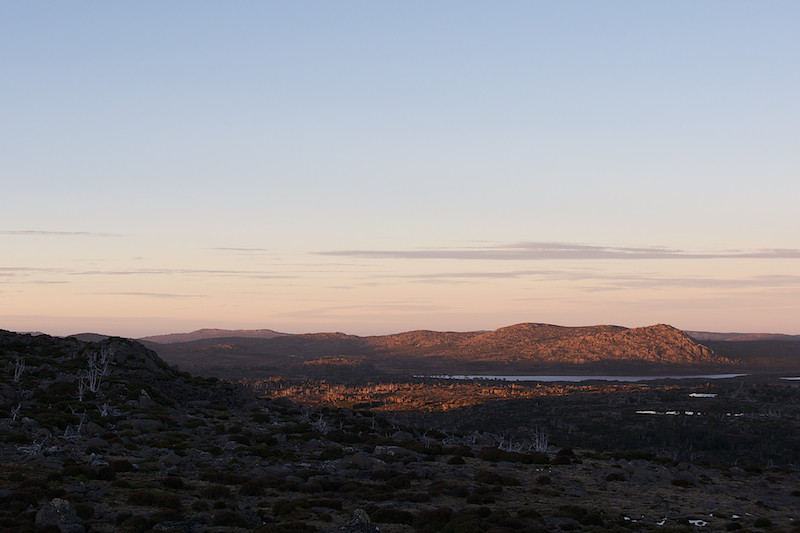
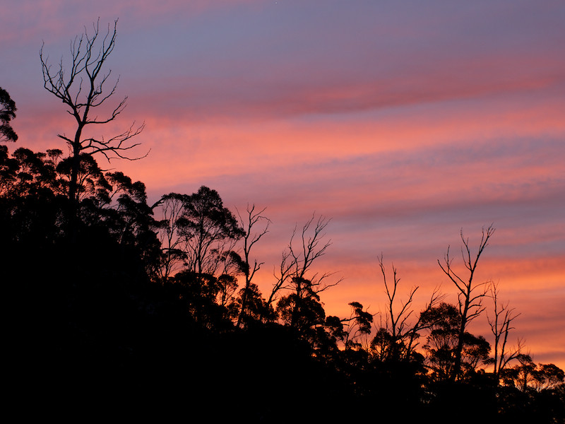
Some shots from a recent four-day, off-track solo walk from Lake MacKenzie to Walls of J. The rough route was: Blue Peaks - Turrana Bluff (night 1) - Long Tarns - Daisy Lakes/Lake Nutting - Zion Gate - Dixons Kingdom (night 2) - Soloman's Throne/King Davids Peak - WDC (night 3, with sunset from the little summit to the north of Herods Gate) - out 
Fantastic trip generally. Found a great campsite amongst the pines by a little tarn near the top of Turrana Bluff (about 1380m) and it was also my first time in the Long Tarns - Zion Gate area, which looked pretty amazing in the mist!
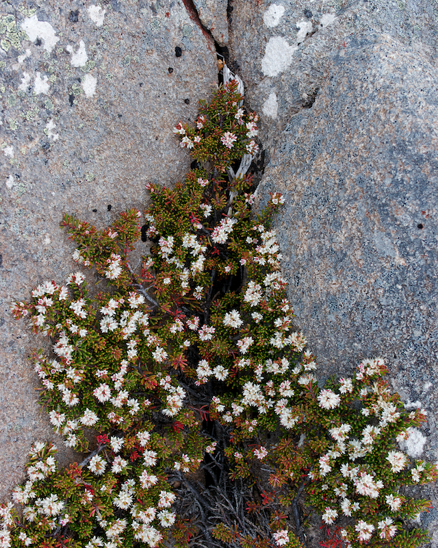
Shot with a GH2, Lumix G 7-14, Nokton 25/f0.95 and SMC M50/f1.4.

Cathedral, Ossa and Pelion West in the distance.


West from Herods Gate.

Clumber Bluff

Turrana Bluff
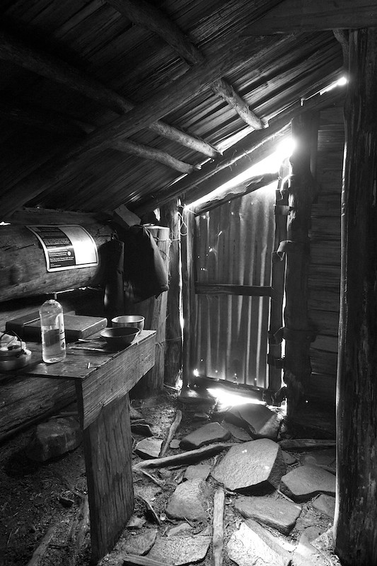
Dixons Kingdom Hut
Mt Jerusalem
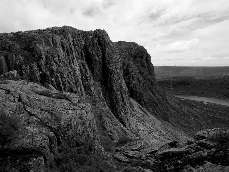
West Wall and King Davids Peak
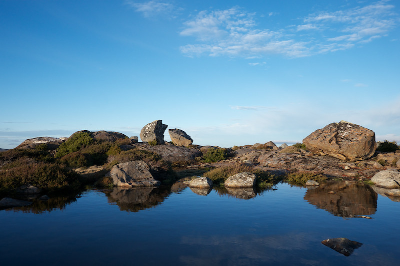
Blue Peaks from night 1 campsite.
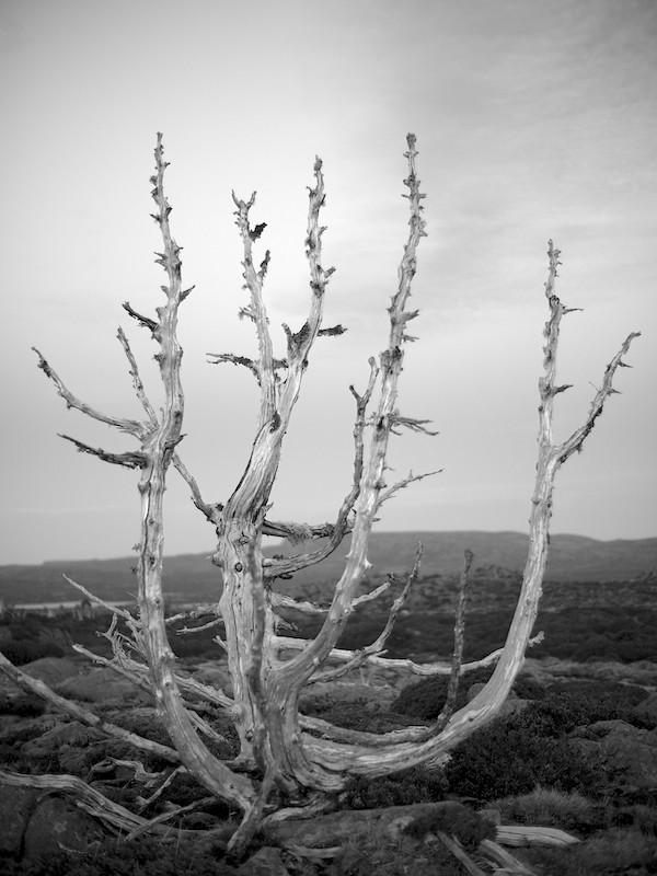
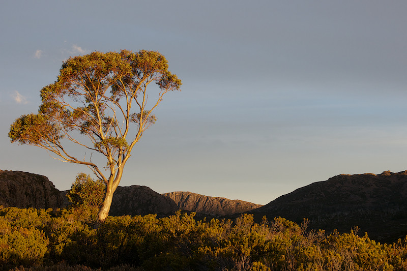
Dead pine on the Plateau
Fantastic trip generally. Found a great campsite amongst the pines by a little tarn near the top of Turrana Bluff (about 1380m) and it was also my first time in the Long Tarns - Zion Gate area, which looked pretty amazing in the mist!
Shot with a GH2, Lumix G 7-14, Nokton 25/f0.95 and SMC M50/f1.4.
Cathedral, Ossa and Pelion West in the distance.
West from Herods Gate.
Clumber Bluff
Turrana Bluff
Dixons Kingdom Hut
Mt Jerusalem
West Wall and King Davids Peak
Blue Peaks from night 1 campsite.
Dead pine on the Plateau
Re: MacKenzie - WoJ
Tue 22 Nov, 2011 6:47 am
Beautiful photos Nick from a most beautiful area!
Re: MacKenzie - WoJ
Tue 22 Nov, 2011 7:44 am
Great shot inside Dixons Kingdom Hut, it works really well in mono with the contrasting outside light streaming through.
Re: MacKenzie - WoJ
Tue 22 Nov, 2011 5:01 pm
Nice images!
Dave
Dave
Re: MacKenzie - WoJ
Wed 23 Nov, 2011 6:06 am
Fantastic photos. A ramble across the plateau gives plenty of opportunities and energy for photography. Thanks for sharing.
Re: MacKenzie - WoJ
Wed 23 Nov, 2011 10:43 am
Nice collection of pics, thanks  , imagined it would be easy walking (a Stroll)
Re: MacKenzie - WoJ
Wed 23 Nov, 2011 3:36 pm
Nuts wrote:Nice collection of pics, thanks
Yeah, from Lake MacKenzie to Long Tarns it's very open and easy walking (very much a stroll
Re: MacKenzie - WoJ
Fri 25 Nov, 2011 6:19 pm
I have an old map but even on that the track peters out at the tarns, apparently no fish to the south of there? I was trying to get an 'easy' walk organised through to WofJ so that's not the best news. Nice pics just the same.
Re: MacKenzie - WoJ
Fri 25 Nov, 2011 7:05 pm
I've walked that way a fair bit over the years and never had a problem with scrub - even navigating in wet misty weather. All the scrubby areas can be walked around if you take the time to find an easy path. I have gone right and left to get around the Daisy Lakes (from Long Tarns to WoJ direction) - and both ways are good. I've only gone left around Lake Tyre - and that is open to the lake - then pick up clear leads around the lake a short bit then down to the open lower flats that lead up to the WoJ.
I have sometimes seen cairns on the left side - and followed them for a bit - but it is not worth it. They offer no advantage - too much time is spent looking out for the next cairn, and its just as easy to find your own route (and i think more scenic - as you can follow a skyline with great views of the Daisy Lakes. Great country and lots of nice campsites on the way.
Dave
Re: MacKenzie - WoJ
Fri 25 Nov, 2011 7:20 pm
Walked through there a few years back and there was a definite pad to the SE of Long Tarns, a little towards Lake Butters.
Interesting is Nutting's cross which is right alongside this pad. Fantastic country out there.
FF
Interesting is Nutting's cross which is right alongside this pad. Fantastic country out there.
FF
Re: MacKenzie - WoJ
Fri 25 Nov, 2011 7:34 pm
..
Last edited by Nuts on Sat 26 Nov, 2011 6:03 pm, edited 1 time in total.
Re: MacKenzie - WoJ
Fri 25 Nov, 2011 7:44 pm
Lovely photos of a great area.
Long Tarns is a big target for describing a walking track.
We crossed it right near its north end and then headed over the ridge and down to North Daisy Lake.
I think the SE track starts way down the other end of the Long Tarns.
It was all pretty good open walking until we headed from North Daisy Lake directly towards Lake Tyre via the valley to the south west.
This valley is lined with multiple moraines running across the valley - making it a lot of steep and rocky up and down and generally scrubby.
By the sounds of it - Dave followed the higher ridge to the east and avoided this.
Then, having gained the heights north of Lake Tyre we encountered a very thick section as we sidled down and across to the east side of Lake Tyre.
I noted in our report that we may have had an easier path if we had proceeded to skirt around South Daisy Lake and then Lake Nutting, but it sounds from Dave's comments like the high ground of the ridge is a good way to go.
Re: MacKenzie - WoJ
Sat 26 Nov, 2011 1:41 pm
eggs wrote:Long Tarns is a big target for describing a walking track.
We crossed it right near its north end and then headed over the ridge and down to North Daisy Lake.
I think the SE track starts way down the other end of the Long Tarns.
It was all pretty good open walking until we headed from North Daisy Lake directly towards Lake Tyre via the valley to the south west.
This valley is lined with multiple moraines running across the valley - making it a lot of steep and rocky up and down and generally scrubby.
By the sounds of it - Dave followed the higher ridge to the east and avoided this.
Then, having gained the heights north of Lake Tyre we encountered a very thick section as we sidled down and across to the east side of Lake Tyre.
I noted in our report that we may have had an easier path if we had proceeded to skirt around South Daisy Lake and then Lake Nutting, but it sounds from Dave's comments like the high ground of the ridge is a good way to go.
I went around the northern end of Long Tarns and then followed the track about half way along, before crossing Scoparia Ridge (or is it Richea Ridge?) to the west - then made my way between South Daisy and Nutting, following Nutting towards the south and then heading SW to Zion Gate.
There were solid pads around Long Tarns, Lake Nutting and from Zion Gate up around the East Wall towards Dixons Kingdom, but I wasn't overly bothered about following them so I'm not sure where they start or finish
Re: MacKenzie - WoJ
Sat 26 Nov, 2011 2:54 pm
OK
- so we crossed to the top of North Daisy from the top of Long Tarns and found a pretty clean line, while you were further down.
I can see from my photos that further down could have been a lot thicker with Scoparia.
scrubmaster had warned me that for this walk gaiters were a must because of the smaller but thick scoparia.
It is interesting though that the scrub that I did find troublesome wasn't scoparia - but more tangles of various bushes with lots of twigs to stick into you.
On reflection though - it wasn't all that bad, just a bit annoying and hot at the time.
Re: MacKenzie - WoJ
Sat 26 Nov, 2011 3:01 pm
Nutting's cross, near Long tarns, alongside what I think is Ritters track.
- Attachments
-
- 09-29-2007 07;59;27pm (2).jpg (144.23 KiB) Viewed 27409 times
Re: MacKenzie - WoJ
Sat 26 Nov, 2011 3:31 pm
flyfisher wrote:Nutting's cross, near Long tarns, alongside what I think is Ritters track.
Interesting, I never saw that... Who was the bloke?
Re: MacKenzie - WoJ
Sat 26 Nov, 2011 5:52 pm
Hi ntt, the bloke who died there was William Nutting after who Lake Nutting is named. He was a hunter and apparently died from cold and exposure.The cross isn't at Lake nutting but is a k or 2 further to the south east. I was out there with my brother in law a few years back on a walking-fishing trip when we found it. It was placed there by Reg Dixon (of Dixons kingdom) and Simon Cubit some years back.
We were walking a marked track which we took to be Ritters track due to the depth of the pad.
We were walking roughly ne and when we came to the top of the scarp falling away between long tarns and lake Butters, it was easily seen for a long way, heading north.We didn't keep following it as our interest lay elsewhere.
We had fished in the lake Gwendy area a few years earlier and seen widely spaced moss covered cairns on big rocks heading to the Long tarns-Butters area.
ff
Re: MacKenzie - WoJ
Sun 27 Nov, 2011 10:46 am
Thanks FF! It's definitely an area I'd like to explore more
Re: MacKenzie - WoJ
Tue 29 Nov, 2011 1:50 pm
Nice set of photos Nick.
Re: MacKenzie - WoJ
Wed 25 Apr, 2012 2:01 pm
If anyone's interested, I've started a bit of a walking/photography blog and have a full report written up about this walk
http://peopleandotherstrangecreatures.w ... jerusalem/
Goes without saying that this is just personal reflections and not a walking guide... Go find a map and compass if planning to do it yourself
http://peopleandotherstrangecreatures.w ... jerusalem/
Goes without saying that this is just personal reflections and not a walking guide... Go find a map and compass if planning to do it yourself
Re: MacKenzie - WoJ
Mon 25 May, 2015 8:48 pm
Nic your pictures are stunning. Thanks
Re: MacKenzie - WoJ
Wed 27 May, 2015 10:49 am
Gorgeous photos. Thanks for posting.
© Bushwalk Australia and contributors 2007-2013.