I am going to take 2 weeks, starting mid April, to do this.
Any advice from people who've done it recently?
I have the John Chapman book, PLB (spot), and winter gear, including Yowies just in case.
Cheers bushwalkers.
AAWT Walhalla to Hotham
32 posts
• Page 1 of 2 • 1, 2
AAWT Walhalla to Hotham
![]() by nihil » Tue 03 Apr, 2012 10:49 am
by nihil » Tue 03 Apr, 2012 10:49 am
- nihil
- Atherosperma moschatum

- Posts: 60
- Joined: Tue 27 Sep, 2011 7:11 pm
- Region: Victoria
- Gender: Male
Re: AAWT Walhalla to Hotham
![]() by Craig D » Tue 03 Apr, 2012 7:52 pm
by Craig D » Tue 03 Apr, 2012 7:52 pm
Leave the Yowies at home, you won't need them. Any snow that falls at that time of year will be gone within a day or two. Water shouldn't be an issue as we've had a wet summer. Can't help with current track conditions though.
My blog: Pauciflora Adventures
-

Craig D - Nothofagus gunnii

- Posts: 28
- Joined: Sat 27 Nov, 2010 9:35 am
- Region: Victoria
- Gender: Male
Re: AAWT Walhalla to Hotham
![]() by DB24 » Wed 04 Apr, 2012 8:35 am
by DB24 » Wed 04 Apr, 2012 8:35 am
Can only comment on the first section around Mt Baw Baw, which I was at on the weekend. Track condition is good albeit a little scrubby and muddy around the plateau.
Have fun!
Have fun!
- DB24
- Nothofagus gunnii
- Posts: 44
- Joined: Thu 23 Feb, 2012 3:07 pm
- Region: Victoria
- Gender: Male
Re: AAWT Walhalla to Hotham
![]() by north-north-west » Wed 04 Apr, 2012 7:07 pm
by north-north-west » Wed 04 Apr, 2012 7:07 pm
DSE have been doing a lot of trackwork recently, so I suspect you will be OK most of the way.
"Mit der Dummheit kämpfen Götter selbst vergebens."
-

north-north-west - Lagarostrobos franklinii

- Posts: 15143
- Joined: Thu 14 May, 2009 7:36 pm
- Location: The Asylum
- ASSOCIATED ORGANISATIONS: Social Misfits Anonymous
- Region: Tasmania
Re: AAWT Walhalla to Hotham
![]() by bernieq » Thu 05 Apr, 2012 5:27 pm
by bernieq » Thu 05 Apr, 2012 5:27 pm
Have a look at Chapman's AAWT update page http://www.john.chapman.name/aawt-upd.html for fairly current track info.nihil wrote:Any advice from people who've done it recently?
You will find the regrowth very slow going from Catherine Saddle to Barry Saddle - particularly from the Razor to the Viking and even more so if it's wet.
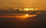
Try to plan an overnight at Mt Speculation - one of the best campsites in Victoria, IMO.
- Campsite at Mt Speculation - looking west over the head of the Wonnangatta Valley to the Viking and the Razor
-
bernieq - Phyllocladus aspleniifolius

- Posts: 698
- Joined: Tue 17 Jan, 2012 3:43 pm
- Region: Victoria
Re: AAWT Walhalla to Hotham
![]() by nihil » Sun 08 Apr, 2012 5:13 pm
by nihil » Sun 08 Apr, 2012 5:13 pm
bernieq wrote:Have a look at Chapman's AAWT update page http://www.john.chapman.name/aawt-upd.html for fairly current track info.nihil wrote:Any advice from people who've done it recently?
You will find the regrowth very slow going from Catherine Saddle to Barry Saddle - particularly from the Razor to the Viking and even more so if it's wet.
Try to plan an overnight at Mt Speculation - one of the best campsites in Victoria, IMO.
Wow, that looks like a great spot to camp. I will definitely stop there. Perhaps a rest day there. Is the spot in that shot hard to find?
- nihil
- Atherosperma moschatum
- Posts: 60
- Joined: Tue 27 Sep, 2011 7:11 pm
- Region: Victoria
- Gender: Male
Re: AAWT Walhalla to Hotham
![]() by bernieq » Sun 08 Apr, 2012 5:47 pm
by bernieq » Sun 08 Apr, 2012 5:47 pm
No, not difficult to find – GDA94 55 E468890 N5891380 (or in 6-digit form : 689914)
From the summit of Mt Spec, follow the track and descend WNW. It’s 500m to the saddle which is at the head of the track up from Camp Creek (the campsite water supply). Although there is great camping 25m WNW past the saddle, walk a few tens of meters further (along the edge) to this campsite, screened by a few snow-gums.
Note that, throughout this whole camping area, toileting should be accomplished over the edge to the west – it’s steep but quite manageable – anywhere east of the campsite is in the Camp Creek catchment.
-
bernieq - Phyllocladus aspleniifolius
- Posts: 698
- Joined: Tue 17 Jan, 2012 3:43 pm
- Region: Victoria
Re: AAWT Walhalla to Hotham
![]() by wildlight » Tue 10 Apr, 2012 12:22 pm
by wildlight » Tue 10 Apr, 2012 12:22 pm
There has been very recent track work on Mt McDonald. Numerous campsites exist along the summit ridge. Three hundred meters in either direction from the point where the track swings abruptly south from east, will give you awesome grandstand vistas.
Although the Mt Speculation photo represents an outstanding camp/photo opportunity... I would say that Mt Mac is right up there with the best also.
The annoyance of Mac is water. Once the very well made walking track becomes a jeep track (heading east) you'll soon hit a more major jeep track. Turn right there, and walk until you meet the gully ( sorry no maps here at work ) which is around 1200 meters from the intersection. If it's only a trickle- you haven't walked far enough south along the track- another 15 mins or less will get you there. There is a bit of a soak on the track just 50 meters from the intersection- if you have the means of filtering, this is ok for most folk. I went with some very high maintenance friends 2 years ago- they're still alive- and enjoyed more of that water in january this year. When you get to the headwaters of the Barkly- the gully I write about here- look in the ferns on the west site of the jeep track, there is a beautiful pool fed by the creek- with absolutely sweet water. It saves you wrestling with cups and receptacles on the east side of the track.
There is also another water point if you turn left (North) to Clear Creek, before taking the Nobs walking track East fro the jeep track. 200 meters along this track there is a water point which will be well and truly alive with all this rain- it's even good "ish" in the middle of Summer- but be prepared to filter it, as it's "still" water. It's good to know these little spots when planning/detouring- try, just like the Mt Spec overnight camp, to also get an overnight on Mt Mac if your weather looks anything less intense than pea soup fog.
I wish you a wonderful trip. I am slowly working around my partner's concerns about doing the same walk! She's coming 'round slowly, slowly. Hopefully before I'm 95!
Safe Steps
WildLight
- wildlight
- Athrotaxis cupressoides

- Posts: 215
- Joined: Tue 24 Mar, 2009 2:03 pm
Re: AAWT Walhalla to Hotham
![]() by bernieq » Tue 10 Apr, 2012 2:08 pm
by bernieq » Tue 10 Apr, 2012 2:08 pm
Mt MacDonald summit is a great spot, to be sure, but water availability is one of the key criteria of a great campsite. It’s also very exposed.
The two water points to which Wildlight refers, down the SOB Tk, are at GDA94 55 E454376 N5872969 and E453955 N5872199. The first one is marked in Chapman’s book – the 2nd is a further 1.5km down the track. As the closest water to the Mt Mac summit at nearly 5km beyond with 500m descent, it’s a long way to backtrack just for the views.
Another plan, if Mt Mac had to be the campsite, would be to carry sufficient water from Low Saddle (8km and 200m up).
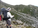
- Mt MacDonald, from the 1572m knoll W of the summit – Nov 2011
- Mt MacDonald 1.JPG (192.47 KiB) Viewed 32845 times
The two water points to which Wildlight refers, down the SOB Tk, are at GDA94 55 E454376 N5872969 and E453955 N5872199. The first one is marked in Chapman’s book – the 2nd is a further 1.5km down the track. As the closest water to the Mt Mac summit at nearly 5km beyond with 500m descent, it’s a long way to backtrack just for the views.
- Lunch on Mt MacDonald, looking E – Nov 2011
- Mt MacDonald 2.JPG (201.95 KiB) Viewed 32845 times
Another plan, if Mt Mac had to be the campsite, would be to carry sufficient water from Low Saddle (8km and 200m up).
-
bernieq - Phyllocladus aspleniifolius
- Posts: 698
- Joined: Tue 17 Jan, 2012 3:43 pm
- Region: Victoria
Re: AAWT Walhalla to Hotham
![]() by ricknsue » Thu 12 Apr, 2012 9:35 am
by ricknsue » Thu 12 Apr, 2012 9:35 am
nihil wrote:I am going to take 2 weeks, starting mid April, to do this.
Any advice from people who've done it recently?
I have the John Chapman book, PLB (spot), and winter gear, including Yowies just in case.
Cheers bushwalkers.
We have just returned from completing the AAWT and the Walhalla to Hotham is very tough as you would expect. Track conditions are OK except for the Catherine to Barry saddle and beyond to the East Riley road. The regrowth is diabolical. We did Catherine to Barry in one day and I am still break into cold sweats when I relive it.
After you get to Hotham I would recommend the Parma at the General. It is magnificent.
Enjoy your walk.
We left Walhalla on 04 March and took 18 days to Hotham.
- ricknsue
- Nothofagus gunnii
- Posts: 20
- Joined: Tue 21 Jul, 2009 9:08 am
Re: AAWT Walhalla to Hotham
![]() by dplanet » Thu 12 Apr, 2012 7:23 pm
by dplanet » Thu 12 Apr, 2012 7:23 pm
What is mobile phone coverage on this section? Interested to know for contacts for weather forecasts and transport for a solo hiker. My friend is not keen. Recently solo hiked the section from Walhalla to Stronachs Camp. Also solo traversed The Viking Circuit a while back. For sure, I had completed the AAWT on YHA club trips over the holiday seasons. Have had J&M Chapman and John Sisemans guidebook; but haven't got a chance to go through it and think of doing it late this year with the start from Stronachs Camp. Thanks.
-
dplanet - Phyllocladus aspleniifolius
- Posts: 580
- Joined: Thu 04 Oct, 2007 8:21 pm
- Location: Ormond-Caulfield, Melbourne
- Region: Victoria
- Gender: Female
Re: AAWT Walhalla to Hotham
![]() by bernieq » Thu 12 Apr, 2012 7:45 pm
by bernieq » Thu 12 Apr, 2012 7:45 pm
Coverage depends on your phone and service provider – with a Telstra blue-tick phone, coverage is available from many/most high points between Mt MacDonald and the Viking (from the cell on Mt Buller) Through the Barry Ranges, coverage is limited until you get to Mt Selwyn (maybe) but improves as you get closer to Mt Hotham. If not Telstra or not a blue-tick phone, coverage is very limited.dplanet wrote:What is mobile phone coverage on this section?
We are responsible for the health of the planet - not it for ours
-
bernieq - Phyllocladus aspleniifolius
- Posts: 698
- Joined: Tue 17 Jan, 2012 3:43 pm
- Region: Victoria
Re: AAWT Walhalla to Hotham
![]() by dplanet » Thu 12 Apr, 2012 8:11 pm
by dplanet » Thu 12 Apr, 2012 8:11 pm
I have a telstra blue-tick phone and it got coverage quite well on Desert Discovery Walk in Little Desert NP last month. Thanks bernieq.
-
dplanet - Phyllocladus aspleniifolius
- Posts: 580
- Joined: Thu 04 Oct, 2007 8:21 pm
- Location: Ormond-Caulfield, Melbourne
- Region: Victoria
- Gender: Female
Re: AAWT Walhalla to Hotham
![]() by wildlight » Fri 13 Apr, 2012 6:37 am
by wildlight » Fri 13 Apr, 2012 6:37 am
bernieq wrote:Another plan, if Mt Mac had to be the campsite, would be to carry sufficient water from Low Saddle (8km and 200m up).
Only 200m up?
Mrs and I lugged/hauled/ferried thirty-two liters of water between us, when we left the SOB track for Mac, this recent New Years Eve. Of course not all of it made it to Mac summit- but it would be fair to say when we arrived on the summit we definitely had at least 8 litres each, with a couple litres a little further east- 2k or a bit more east of the summit ( and much of our "stuff" was left there too! )
We were going for photos, and like I said to my partner- it's not far to walk if we run out of water (we didn't run out).
But I hear you- from the 2nd WP on the SOB track- it's a helluva long haul back to the summit for the views. Would hate to have the memory card full, or the battery go flat on arrival- or be greeted by pea soup fog.
While I'm a big believer in going light when possible, sometimes we do carry more water when needed. I have been at campsites (Viking Saddle in dry summers) where people have been gone for almost two hours to get water, gullies were so dry. On those kinda walks, I bit the bullet and just carried a few extra litres, figuring it might be a pain on the back for a while, but it saves the messing around later of having to go search for water. We went to Hell's Window the day the gates were reopened after the big fires- and I bashed down Hellfire Gully for an hour and a half, with not even moisture there, let alone any potable water. On that walk, we had no "reserve", so reluctantly went back to Maccy springs for the night.
Cheers
Safe Steps
Wildlight
- wildlight
- Athrotaxis cupressoides
- Posts: 215
- Joined: Tue 24 Mar, 2009 2:03 pm
Re: AAWT Walhalla to Hotham
![]() by dplanet » Sat 14 Apr, 2012 7:33 am
by dplanet » Sat 14 Apr, 2012 7:33 am
dplanet wrote: think of doing it late this year with the start from Stronachs Camp. Thanks.
Having gone through the guidebook Track Summary, p6 and the map AAWT 1-4, p51, my walk plan is divided into two sections. The 1st section is from Thomson River campsite to Upper Howqua camping area via Helicopter Spur (not to Mt Howitt) mainly due to transport access (?). The start from Stronachs is also cancelled in order to avoid few kms of walking on road. Can't make up my mind where to start for the 2nd section.
-
dplanet - Phyllocladus aspleniifolius
- Posts: 580
- Joined: Thu 04 Oct, 2007 8:21 pm
- Location: Ormond-Caulfield, Melbourne
- Region: Victoria
- Gender: Female
Re: AAWT Walhalla to Hotham
![]() by wildlight » Fri 20 Apr, 2012 12:38 am
by wildlight » Fri 20 Apr, 2012 12:38 am
dplanet,
what about for the second section you get transport to Maccy springs carpark, ( 2WD-friendly, via Licola )- and walk to Howitt, either go across to Hell's Window for a night and then continue along the AWT Hotham-bound (with a small retrace of steps next day)- or just turn north at the Crosscut Saw, and head for Mt Speculation? It's a beautiful part of the walk, you wouldn't want to be missing too much of that section.
Safe steps
Wildlight
- wildlight
- Athrotaxis cupressoides
- Posts: 215
- Joined: Tue 24 Mar, 2009 2:03 pm
Re: AAWT Walhalla to Hotham
![]() by dplanet » Fri 20 Apr, 2012 7:29 pm
by dplanet » Fri 20 Apr, 2012 7:29 pm
Been to this area for a number of times with clubs. From memory, the last time was on a solo hike tackling The Viking Circuit. Still have plenty of time for the 2nd section plan.
-
dplanet - Phyllocladus aspleniifolius
- Posts: 580
- Joined: Thu 04 Oct, 2007 8:21 pm
- Location: Ormond-Caulfield, Melbourne
- Region: Victoria
- Gender: Female
Re: AAWT Walhalla to Hotham
![]() by nihil » Tue 22 May, 2012 6:16 pm
by nihil » Tue 22 May, 2012 6:16 pm
Trip completed. I got back on the 11th. Quite the adventure, actually. I am now 11 kilos lighter. It ended up taking 20 days instead of 14. I think that was due to the short days with sunset at 5:30 and last light at 6.
Jogging down Mount MacDonald (yes, it is quite the spectacular viewpoint) my GPS 60CX came off my pack somehow. Then the following three days were a constant cloud of 20 meters visibility. I stayed in my tent and read the kindle, eating my emergency peanut butter and wondering if I should turn back or rely on my compass and map skills. Finally the cloud dispersed and I went on, calibrating my map, compass and brain at The Knobs. After working out that I had turned the declination in the wrong direction, I managed to get 5deg accuracy on peaks and map lines and decided that compasses are awesome. Hunters and their dogs accompanied me on my climb around High Cone and Mount Clear, and one gave me a whole block of chocolate.
As people have noted, there's a lot of recent track clearing work on the trail, with fresh yellow sawdust. However, coming off The Viking, it's not so great, and the foot pad is intermittent. I departed from the trail coming down the cliffs off the Viking and got stuck sleeping in the gully slightly east of the trail. A depressing night spent tuning up my map reading skills and perpetually sliding down my tent with every micro-movement. Found the trail again in the morning with a lot of compass work, resulting in much elation and relief.
The overgrowth and lack of water from The Viking along the first half of the Barry Mountains was really unpleasant. There are parasites swimming in the tank at Barry saddle, and some turkey left the tap on at the Barry Mountains water tank; It would have been a great camp site, but I had to go on to the next camp site because there was no water in the creek at Viking Saddle. At the next camp site somehone had left the dregs of a water drop, which was pretty dirty but I boiled it and filtered it. It was heaven. The whole day I was sipping water from leaves and wondering why I didn't just treat the water at Barry Saddle.
The final two days were wonderful relief due to easy navigation and plenty of water. The sun broke through as I went up Hotham, creating dramatic light beams through rushing clouds pushing up from the valleys.
My previous hike was The Overland, and though I did half as much walking on that, this was certainly orders of magnitude more difficult. To anyone considering doing something like this, definitely don't rely on GPS. Think of it as a secondary measure. Compasses and maps are more hardy and very accurate if you have the knowledge and the right kind of compass. It's also much more satisfying to track your position in your head instead of delegating that to a machine. I suspect most people here know this well.
What a beautiful broad and majestic alpine region we have. I will never forget seing The Bluff from Mount MacDonald lit beautifully from the east.
Oh also, for solo hikers going through the rock chimney up The Viking, don't be thick like me and try to drag your pack up with a rope: I found it much easier to carry/throw up the contents one by one, but it took me an hour of panicked struggle before my thinking self kicked back in.
Thanks to everyone who contributed advice and information to this thread.
- nihil
- Atherosperma moschatum
- Posts: 60
- Joined: Tue 27 Sep, 2011 7:11 pm
- Region: Victoria
- Gender: Male
Re: AAWT Walhalla to Hotham
![]() by iGBH » Tue 22 May, 2012 7:23 pm
by iGBH » Tue 22 May, 2012 7:23 pm
Awesome report back, good to know you made it. Would love to see some photos if you didn't lose the camera too?
- iGBH
- Athrotaxis cupressoides
- Posts: 135
- Joined: Sat 29 Jan, 2011 8:19 pm
- Region: Victoria
- Gender: Male
Re: AAWT Walhalla to Hotham
![]() by MartyGwynne » Tue 22 May, 2012 9:30 pm
by MartyGwynne » Tue 22 May, 2012 9:30 pm
Well done. Looking forward to photos.
By the way did you happen to see and old steel camp stool where you camped off the Viking (we got a bit lost there once and spent a cramped night)
The Viking chimney could be a bit tricky by yourself, but last time I went up there one of our long legged fellows walked up around it on the right hand side carrying his pack. It was almost like a set of stairs for him, you just need to have a bit of nerve to do it.
Also there is water off the east side of the Viking if there is none at the saddle you need to walk down a bit of a gully about 1 km down and there is a bit of a soak coming from the rocks and pooling quite well (well it was when we were there).
Marty.
-
MartyGwynne - Athrotaxis cupressoides
- Posts: 355
- Joined: Sun 30 Jan, 2011 4:31 am
- Region: Victoria
- Gender: Male
Re: AAWT Walhalla to Hotham
![]() by Moondog55 » Thu 24 May, 2012 6:57 am
by Moondog55 » Thu 24 May, 2012 6:57 am
Nice update, many thanx for the report. Wow 11 kilos in 18 days??
Were you hungry some of the time or most of the time and what ration planning did you do that you would do differently next time?
Were you hungry some of the time or most of the time and what ration planning did you do that you would do differently next time?
Ve are too soon old und too late schmart
- Moondog55
- Lagarostrobos franklinii
- Posts: 11113
- Joined: Thu 03 Dec, 2009 4:15 pm
- Location: Norlane Geelong Victoria Australia
- Region: Victoria
- Gender: Male
Re: AAWT Walhalla to Hotham
![]() by nihil » Fri 25 May, 2012 12:21 am
by nihil » Fri 25 May, 2012 12:21 am
No photos unfortunately. My camera started malfunctioning on the 4th day. It's just as well since I am a photographer and I would have fussed with the camera way too long and not gotten to camp on time!
Marty I didn't see a steel chair. What I did find was a tract of pink tape that led along what seemed to be an old AAWT track (there was one 70's track marker I saw as I was going off trail). This gave me a false sense of confidence as I was heading slightly east of the trail. I guess this is the doing of official walkers, but the presence of these 'ghost' trails from a while back can be a problem. The vegetation is so thick down there, and I didn't notice it on the way down, but trying to cross into the gullies to correct across the mountain (rather than acceding then crossing over) means you move at sloth speed. I really feel for the people who had to make their way through that between the Razor and Viking Saddle. I kind of smirked at the Chapman/Seisman notes about it being critical that one does not descend into scrubby gullies, but I know now that contending with them means you're likely going to spend a night down in them!
Great note about the soak. I would love to spend a rest day and two camps on the Razor. It's got some perfect camping spots (marked by camp fires; I would use my bushbuddy at the most) with perhaps the most impressive views of the trail overall.
How did you manage to schlep a chair like that?
Moondog, I think I was running on ketosis (the consumption of one's body fat for energy) for the middle to end of each day, since after the first 3 days I didn't feel a great desire to stop for lunch, and I would often just cut lunch into my dinner. I would have a musli bar, a snake (natural confectionary company), mini mars bar x2. I had vitawheats with salami and cheese but I was always reluctant to stop. Eventually my breaks would last for on average 2 minutes, and no longer than 10 minutes, and I would go like that all day from 9 to 5. I don't think it was a sustainable routine. I was always feeling an adrenaline rush to move on to the next camp; I've never done anything on this scale so I was very careful to leave plenty of margin for error, including food. I actually had 2 meals left over at the food drop which I left in the container due to weight. In the bottom of my pack was a decent amount of peanut butter, which I ate exclusively during my hibernation period waiting out the cloud and rain. That would have contributed to my weight loss, since there's very little carbs in there and the body would be forced to burn fat.
- nihil
- Atherosperma moschatum
- Posts: 60
- Joined: Tue 27 Sep, 2011 7:11 pm
- Region: Victoria
- Gender: Male
Re: AAWT Walhalla to Hotham
![]() by nihil » Fri 25 May, 2012 12:35 am
by nihil » Fri 25 May, 2012 12:35 am
RE: ration planning: I don't know, I was pretty happy with my food selection. I was sad that I didn't bring tea bags or marsh mellows. I did eat instant noodles for dinner a couple of nights, which seemed to be a little insubstantial actually (duh). More nutritional meals in the evening I guess. My favorite was pasta vegetariano, with salami and parmesan cut in. That felt really wholesome. More muesli bars perhaps.
- nihil
- Atherosperma moschatum
- Posts: 60
- Joined: Tue 27 Sep, 2011 7:11 pm
- Region: Victoria
- Gender: Male
Re: AAWT Walhalla to Hotham
![]() by MartyGwynne » Fri 25 May, 2012 11:12 am
by MartyGwynne » Fri 25 May, 2012 11:12 am
I did not carry the chair in but another guy (not much of a walker) he used it the first night at Catherine saddle then sat straight through it the second night. That was a great party trick for us who were a bit geographically embarrassed (but only 400 m from the track as per our navigators GPS) we camped on the edge of a cliff of 40 m (just enough to jam 3 tents up). So we set the chair up in a prominent position so it would be seen if anyone went there/got lost there again.
Tea bags? Nihil Why do people carry tea bags. I just carry a small bag of tea (about 80 grams was way too much for a 7 night walk) make sure they are of the large leaf type such as T2 brand (are we allowed to mention brands?) I like the Early Grey flavour and only have it black so it is good to give the hot dirty water some good flavour.
Also I am OK about tipping out the used leaves onto the ground as it blends in well with the other vegetable matter and you don't have to lug out or burn soggy tea bags (or alternatively flick them into the bushes as can be seen at times).
Sorry I must make this post on its own...
11 kg weight loss sounds good I should do it and feel thin again.
How much weight have you put back on again? Did you have that much weight to loose in the first place?
Marty.
-
MartyGwynne - Athrotaxis cupressoides
- Posts: 355
- Joined: Sun 30 Jan, 2011 4:31 am
- Region: Victoria
- Gender: Male
Re: AAWT Walhalla to Hotham
![]() by nihil » Fri 25 May, 2012 11:48 am
by nihil » Fri 25 May, 2012 11:48 am
I weighed 94 and I am 180cm, so I would have been considered overweight, and I did look pretty pudgy. Now I look thin, like my early 20s (I'm late 20s). The great thing is my waist line is below 100cm which is the primary risk factor for diabetes. I haven't put on any more weight because I haven't been eating carbohydrates so my body is forced to use body fat. I have a problem with eating and hiking was part of the plan from the get go, so it's gratifying to have it work out. I ran into two AAWT hikers who were on day 39 from Tharwa. They looked like plane crash survivors they had lost so much weight. It's just the nature of the trail I think. I believe the section I did consists of 1.5 Mt Everests! And the whole thing is x4.
- nihil
- Atherosperma moschatum
- Posts: 60
- Joined: Tue 27 Sep, 2011 7:11 pm
- Region: Victoria
- Gender: Male
Re: AAWT Walhalla to Hotham
![]() by bernieq » Fri 25 May, 2012 3:07 pm
by bernieq » Fri 25 May, 2012 3:07 pm
Well done, nihil – a great tramp with many demanding sections, all the more so as a solo walk.
The parasites in the Barry Saddle tank are just mosquito larvae (wrigglers) – filter them out (eg with a cloth) or swallow them – they don’t do any harm (extra protein – yummm :)
There are currently markers (both old AWT and newer AAWT style) through this section (the descent from the Viking) but care is still needed.
Again, well done - a great sense of achievement.
Pity about the GPS but you are correct – it’s a useful aid but map and compass (and the knowledge of how to use them) are still essential for any wilderness walk.nihil wrote:definitely don't rely on GPS. Think of it as a secondary measure. Compasses and maps are more hardy and very accurate if you have the knowledge and the right kind of compass.
Heading up through the Viking chute, you have two choices – through the hole or to the LEFT. Through the hole requires dragging your pack up (tedious with a group, not easy by yourself). To the LEFT, requires edging out along a branch and around a small rocky edge, climbing up the rock to a log with a foot-notch cut in it, and stepping onto firm ground again – much easier and quicker (not at all difficult, but does require confidence with heights). To the right is not an option as it's a vertical rockface.MartyGwynne wrote:The Viking chimney could be a bit tricky by yourself, but last time I went up there one of our long legged fellows walked up around it on the right hand side carrying his pack. It was almost like a set of stairs for him, you just need to have a bit of nerve to do it.
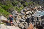
- the alternate to the hole at the Viking chute - from above Nov 2009
From Chapman’s AAWT update page : Page 93 - Barry Mountains Water Tank leaks - do not rely on it. New water tank placed on Selwyn South at GR 907995 (installed June 2010)nihil wrote:There are parasites swimming in the tank at Barry saddle, and some turkey left the tap on at the Barry Mountains water tank
The parasites in the Barry Saddle tank are just mosquito larvae (wrigglers) – filter them out (eg with a cloth) or swallow them – they don’t do any harm (extra protein – yummm :)
Yes, it is very easy to do – a wash-away looks very much like a track and the temptation is strong to follow it down into the gully off to the east of the main ridge. It is essential (as you now know) to stick very close to the base of the rocky bluffs on your left (when heading north)nihil wrote:I departed from the trail coming down the cliffs off the Viking and got stuck sleeping in the gully slightly east of the trail
There are currently markers (both old AWT and newer AAWT style) through this section (the descent from the Viking) but care is still needed.
Again, well done - a great sense of achievement.
-
bernieq - Phyllocladus aspleniifolius
- Posts: 698
- Joined: Tue 17 Jan, 2012 3:43 pm
- Region: Victoria
Re: AAWT Walhalla to Hotham
![]() by north-north-west » Fri 25 May, 2012 5:26 pm
by north-north-west » Fri 25 May, 2012 5:26 pm
Ahhh, there's already a note about the Selwyn South water tank. (I was quite surprised seeing that last Saturday. Wish I'd known as it would have saved me carrying that extra 2 litres from Murray. And it's easy to find, even in a reasonably thick fog it's visible from the track, directly across from the summit) That makes three tanks in all covering the 'dry' Barries.
ps: Camping on Selwyn is superb in good weather.
ps: Camping on Selwyn is superb in good weather.
"Mit der Dummheit kämpfen Götter selbst vergebens."
-
north-north-west - Lagarostrobos franklinii
- Posts: 15143
- Joined: Thu 14 May, 2009 7:36 pm
- Location: The Asylum
- ASSOCIATED ORGANISATIONS: Social Misfits Anonymous
- Region: Tasmania
Re: AAWT Walhalla to Hotham
![]() by nihil » Mon 28 May, 2012 4:54 pm
by nihil » Mon 28 May, 2012 4:54 pm
Bernieq, thanks for the notes and congratulations. Everyone on this thread has been very helpful and encouraging, and I am thankful for this great little community. I spent a long time putting together an equipment list and making sure I had the right things in the right amount, but the factor of the unknown meant that I was on altert more than I would have liked for full enjoyment to take place (and then there were times when the environment just transcended that; the highs are higher and the lows are lower on these personal challenges I guess). I look forward to doing it again in warmer weather with more sunlight, so I can enjoy all the things I admired in passing. The only problem is that I will also be looking for a greater challenge now 
You're right on the money about the wash-aways - that's exactly what led me off track. Mind you I was only about 20 to 40 meters away finally. It was one moment of inattention combined with low visibility due to the height of the regrowth (and the fact that there was no visible pad at that point of departure (or track markers of course)).
I did see that log set-up to the left, but it didn't even enter into my mind that people walk up that. Ah ha. I wouldn't have attempted it because I am a real nervous nelly with heights.
- nihil
- Atherosperma moschatum
- Posts: 60
- Joined: Tue 27 Sep, 2011 7:11 pm
- Region: Victoria
- Gender: Male
Re: AAWT Walhalla to Hotham
![]() by wildlight » Wed 30 May, 2012 2:08 pm
by wildlight » Wed 30 May, 2012 2:08 pm
The only problem is that I will also be looking for a greater challenge now
nihill, don't see the desire for a challenge as a problem- view it as the aftermath of a successful walk.
I am in awe at your weight loss and that you have managed to keep it off.
If I did 4 or 5 times that, I'd turn out about right.
Somewhere I read something north-north-west had written about the idea of doing the Larapinta Trail from Alice to Sonder, then turning around and walking back to Alice again. That would do it nicely for me.
Safe Steps
Wildlight
- wildlight
- Athrotaxis cupressoides
- Posts: 215
- Joined: Tue 24 Mar, 2009 2:03 pm
Re: AAWT Walhalla to Hotham
![]() by madmacca » Thu 08 Nov, 2012 11:58 pm
by madmacca » Thu 08 Nov, 2012 11:58 pm
bernieq wrote:Heading up through the Viking chute, you have two choices – through the hole or to the LEFT. Through the hole requires dragging your pack up (tedious with a group, not easy by yourself). To the LEFT, requires edging out along a branch and around a small rocky edge, climbing up the rock to a log with a foot-notch cut in it, and stepping onto firm ground again – much easier and quicker (not at all difficult, but does require confidence with heights). To the right is not an option as it's a vertical rockface.
Bernie,
Thanks for the notes and photo - I was easily able to solo LEFT over Cup weekend with a pack. Getting round the rocky edge led to a few moments of nervousness, but there are plenty of handholds if you search for them.
Mad
- madmacca
- Phyllocladus aspleniifolius
- Posts: 518
- Joined: Fri 14 Oct, 2011 11:18 pm
- Region: Victoria
- Gender: Male
32 posts
• Page 1 of 2 • 1, 2
Who is online
Users browsing this forum: No registered users and 26 guests