milford track - printed topo map

Forum rules
Please avoid publishing details of access to sensitive areas with no tracks.

milford track - printed topo map

Postby dannnnn » Tue 19 Mar, 2013 6:56 pm

hi there,

i am considering doing the milford track and i have been searching for a topo map so i can start planning... and i can't find one. from what i've seen it seems like the track is well marked enough that you won't need a topo map... but i sure as hell want one!! it's half the fun of planning :)

does anyone know where i can buy one??

cheers!

dan
dannnnn
Athrotaxis cupressoides
 
Posts: 168
Joined: Mon 11 Apr, 2011 4:29 pm
Region: Queensland
Gender: Male

Re: milford track - printed topo map

Postby Strider » Tue 19 Mar, 2013 7:11 pm

User avatar
Strider
Lagarostrobos franklinii
 
Posts: 6030
Joined: Mon 07 Nov, 2011 6:55 pm
Location: Point Cook
Region: Victoria
Gender: Male

Re: milford track - printed topo map

Postby wayno » Wed 20 Mar, 2013 3:00 am

i prefer this one for printing http://www.topomap.co.nz/

eventually there will be no pure topomaps of nz. LINZ who have been making them have stopped printing them because there isnt enough demand with the rise of the online maps and DVD's. teh other option is get a DOC park map from DOC. those maps arent as good as the topomaps...
i've never heard of anyone getting lost on the milford. it's a very well cut track, apart from parts of the pass, it's like a dirt and rock footpath. biggest issue is being delayed by rivers flooding too high. plan to be stuck for an extra day or two. if you're walking in the high season, the doc rangers will literally close the track if the flooding gets too high the parts of the track that flood have poles either side so you don't stray off it into the deep drainage ditches. they should still let you walk the track if the water is up to waist deep on those sections. they make up a relatively small part of the track. if you're not walking in the high season, i don't think there are doc rangers in the huts. and you'll have to find out how high the river is yourself and work out posible avalanche danger http://www.doc.govt.nz/parks-and-recrea ... fiordland/
from the land of the long white clouds...
User avatar
wayno
Lagarostrobos franklinii
 
Posts: 8784
Joined: Sun 19 Jun, 2011 7:26 am
Location: NZ
Region: New Zealand
Gender: Male

Re: milford track - printed topo map

Postby Rob A » Wed 20 Mar, 2013 8:27 am

LINZ http://www.linz.govt.nz/topography/topo ... -retailers
Ring or email any of the retailers and get them to put aside any topo you want before you go.
Use the on line maps for any a4 cheat sheets you need to make. www.linz.govt.nz/topography/topo-maps/map-chooser
Ok ... while you dont have to do it for milford ...
Every four seconds, somewhere in the world, an Harlequin Mills and Boon is sold ... Wot ...
Rob A
Phyllocladus aspleniifolius
 
Posts: 506
Joined: Mon 29 Nov, 2010 2:01 pm
Region: New South Wales
Gender: Male

Re: milford track - printed topo map

Postby wayno » Wed 20 Mar, 2013 8:33 am

the topomap.co.nz and nztopomaps sites allow printing of maps you can manually choose the area of map you want to print to suit lot cheaper than buying the maps.

good luck if you try and print the maps from teh linz website, the files are absolutely massive. if you've got an old pc or printer it will struggle to print the files.
from the land of the long white clouds...
User avatar
wayno
Lagarostrobos franklinii
 
Posts: 8784
Joined: Sun 19 Jun, 2011 7:26 am
Location: NZ
Region: New Zealand
Gender: Male

Re: milford track - printed topo map

Postby Rob A » Wed 20 Mar, 2013 10:35 am

LINZ allows you free downloads (rastor/tiff) of the actual topo map and can be a far better source. File sizes are not massive and you can print clean images from sections without any sort of proprietry software. But hey what would I know.

While you are at it you should probably do some valuable research so that you can both immerse yourself and become well versed in Kiwi culture.
Last edited by Rob A on Wed 20 Mar, 2013 10:40 am, edited 1 time in total.
Every four seconds, somewhere in the world, an Harlequin Mills and Boon is sold ... Wot ...
Rob A
Phyllocladus aspleniifolius
 
Posts: 506
Joined: Mon 29 Nov, 2010 2:01 pm
Region: New South Wales
Gender: Male

Re: milford track - printed topo map

Postby wayno » Wed 20 Mar, 2013 10:40 am

yeah the tiff files are the ones i'm refering to. around 90 megs in size.. old computers can have trouble displaying images of that size as well,
from the land of the long white clouds...
User avatar
wayno
Lagarostrobos franklinii
 
Posts: 8784
Joined: Sun 19 Jun, 2011 7:26 am
Location: NZ
Region: New Zealand
Gender: Male

Re: milford track - printed topo map

Postby Rob A » Wed 20 Mar, 2013 10:41 am

Struggle on your abacus I guess. Smaller file sizes on youtube.
Every four seconds, somewhere in the world, an Harlequin Mills and Boon is sold ... Wot ...
Rob A
Phyllocladus aspleniifolius
 
Posts: 506
Joined: Mon 29 Nov, 2010 2:01 pm
Region: New South Wales
Gender: Male

Re: milford track - printed topo map

Postby Lindsay » Fri 22 Mar, 2013 7:44 am

It's great to get out a map and examine your route, but unfortunately all the planning on the Milford track has been done for you by DOC. If walking in season you must catch the allocated ferry to the start, stay at each hut in turn and not bypass or linger at a hut, no camping and make sure you are on time for the allocated ferry at the end. I understand that this is necessary due to the popularity of this walk, however it does make for a rather regimented experience. Still very worth doing though.
User avatar
Lindsay
Phyllocladus aspleniifolius
 
Posts: 679
Joined: Thu 01 Oct, 2009 3:00 pm
Location: Sydney
Region: New South Wales
Gender: Male

Re: milford track - printed topo map

Postby wayno » Fri 22 Mar, 2013 8:00 am

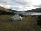
THE FIRST day you have a choice of which boat you take, morning or midday
its only a 5k walk the first day, if you take the morning boat thers lots of time to unwind at the hut, good time to get to know the people you will share the next four days with... thats one good thing you get to catch up with the same people you've gotten to know, its a good communal atmosphere at least it was with the people who i shared the hut with.
if you're lucky at clinton hut your ranger will be peter jackson... he gives a couple of talks, well worth attending, one at dusk about the plant life and look at some glow worms, and if its clear he will give you a rundown of the stars you can see.
theres two boats to choose from on the last day but theres only an hour between them. you dont have to prebook , just get on whichever one is there.
from the land of the long white clouds...
User avatar
wayno
Lagarostrobos franklinii
 
Posts: 8784
Joined: Sun 19 Jun, 2011 7:26 am
Location: NZ
Region: New Zealand
Gender: Male


Return to New Zealand

Who is online

Users browsing this forum: No registered users and 9 guests