THANKS ALL FOR THE HELP AND ADVICE..I HAVE SORTED MY ISSUES...
Why am i 12 Degrees off???
Forum rules
The place for bushwalking topics that are not location specific.
The place for bushwalking topics that are not location specific.
33 posts
• Page 1 of 2 • 1, 2
Why am i 12 Degrees off???
![]() by yegdod1 » Sat 18 Feb, 2012 4:49 pm
by yegdod1 » Sat 18 Feb, 2012 4:49 pm
Taking sight bearings and relaying them to a map....I sight an object & line up compass lines. When i put compass onto the map and draw a line back i am about 12 degrees out 
 . I was using a rooftops map which did NOT have any info about DECLINATION...Is this the problem?,,,,if i adjusted compass for correct DECLINATION would that solve my problems???...I can cross reference my LONGITUDE & LATITUDE on my gps but i am trying not to use it.......
THANKS ALL FOR THE HELP AND ADVICE..I HAVE SORTED MY ISSUES... WENT OUT A COUPLE DAYS AGO AND THERE WAS NO NEED FOR THE GPS...
  ...
...
THANKS ALL FOR THE HELP AND ADVICE..I HAVE SORTED MY ISSUES...
Last edited by yegdod1 on Sat 25 Feb, 2012 7:02 pm, edited 1 time in total.
- yegdod1
- Nothofagus gunnii

- Posts: 12
- Joined: Tue 26 Jul, 2011 6:17 pm
- Region: Victoria
- Gender: Male
Re: Why am i 12 Degrees off???
![]() by alliecat » Sat 18 Feb, 2012 5:29 pm
by alliecat » Sat 18 Feb, 2012 5:29 pm
Yep - it's the magnetic declination or variation that's messing you up. A reasonable summary is at the bushwalking.org FAQ. In short, your compass is not pointing at "grid north" as shown on your map - it is pointing at roughly 12 degrees or so to the east of north. (The exact variation depends on where you are - it should be shown on any decent map.)
There's a nice map showing the declination across all of Australia at Geoscience Australia
People use various mnemonics to remember how to convert from grid to magnetic and back. Personally, I just remember that the compass points 14 degrees east of grid north and adjust accordingly. Some compasses have an adjustment ring so that you can set the declination and use the compass as if it pointed to grid north.
Hope that helps!
Cheers,
Alliecat
- alliecat
- Athrotaxis cupressoides

- Posts: 314
- Joined: Thu 29 May, 2008 2:17 pm
- Region: Tasmania
Re: Why am i 12 Degrees off???
![]() by hikingoz » Sat 18 Feb, 2012 6:27 pm
by hikingoz » Sat 18 Feb, 2012 6:27 pm
I stuffed this up on a recent trip and cut a bearing about 20 degrees in the wrong direction.
The trick that I should have used was "Grand-ma sucks". or "Grid to Magnetic Subtract". I added by mistake.
Hope that helps.
The trick that I should have used was "Grand-ma sucks". or "Grid to Magnetic Subtract". I added by mistake.
Hope that helps.
-
hikingoz - Athrotaxis cupressoides
- Posts: 306
- Joined: Fri 18 Feb, 2011 4:21 pm
- Location: Canberra, ACT
- Region: Australian Capital Territory
- Gender: Male
Re: Why am i 12 Degrees off???
![]() by alanoutgear » Sat 18 Feb, 2012 8:55 pm
by alanoutgear » Sat 18 Feb, 2012 8:55 pm
GrandMother Sucks - Grid to Magnetic subtract - now that's brought back some memories from National Service in the early '70s. The corrollary is MGA (the car) - Magnetic to Grid add. Used GMS a few weeks ago going across the Tassie central plateau and on to Lake Antimony - worked a treat and navigated to within a few metres of Hut 5. Thank you Sgt Kanga Griffiths - I wonder where you are now?
-
alanoutgear - Athrotaxis cupressoides
- Posts: 134
- Joined: Sun 02 May, 2010 9:21 pm
- Region: Victoria
- Gender: Male
Re: Why am i 12 Degrees off???
![]() by ILUVSWTAS » Sat 18 Feb, 2012 9:02 pm
by ILUVSWTAS » Sat 18 Feb, 2012 9:02 pm
Hahaha wow, this is awesome!! I CAN use a compass (somewhat) if i must, just find it so much easier to use the GPS.... 


Nothing to see here.
-

ILUVSWTAS - Lagarostrobos franklinii

- Posts: 11027
- Joined: Sun 28 Dec, 2008 9:53 am
- Region: Tasmania
- Gender: Male
Re: Why am i 12 Degrees off???
![]() by Nuts » Sun 19 Feb, 2012 7:51 am
by Nuts » Sun 19 Feb, 2012 7:51 am
maybe there's a problem with the compass?
anyhow.. What map, perhaps someone could give you the variation, i have an inclination to think that's a lot declination?? (been a long time since ive taken any notice..) it's not the same (for you) on all maps is it ?? checking against the gps should be an easy fix no??
anyhow.. What map, perhaps someone could give you the variation, i have an inclination to think that's a lot declination?? (been a long time since ive taken any notice..) it's not the same (for you) on all maps is it
-

Nuts - Lagarostrobos franklinii
- Posts: 8555
- Joined: Sat 05 Apr, 2008 12:22 pm
- Region: Tasmania
Re: Why am i 12 Degrees off???
![]() by South_Aussie_Hiker » Sun 19 Feb, 2012 10:04 am
by South_Aussie_Hiker » Sun 19 Feb, 2012 10:04 am
In aviation we use:
Variation East - Magnetic least
Variation West - Magnetic best
Might mean when you bushwalk overseas where magnetic variation is west, you won't adjust the wrong way!
Variation East - Magnetic least
Variation West - Magnetic best
Might mean when you bushwalk overseas where magnetic variation is west, you won't adjust the wrong way!
-

South_Aussie_Hiker - Phyllocladus aspleniifolius

- Posts: 906
- Joined: Tue 22 Feb, 2011 9:24 pm
- Region: South Australia
- Gender: Male
Re: Why am i 12 Degrees off???
![]() by yegdod1 » Sun 19 Feb, 2012 11:38 am
by yegdod1 » Sun 19 Feb, 2012 11:38 am
ILUVSWTAS wrote:Hahaha wow, this is awesome!! I CAN use a compass (somewhat) if i must, just find it so much easier to use the GPS....
Gotta learn somehow..
- yegdod1
- Nothofagus gunnii
- Posts: 12
- Joined: Tue 26 Jul, 2011 6:17 pm
- Region: Victoria
- Gender: Male
Re: Why am i 12 Degrees off???
![]() by doogs » Sun 19 Feb, 2012 11:49 am
by doogs » Sun 19 Feb, 2012 11:49 am
yegdod1 wrote:ILUVSWTAS wrote:Hahaha wow, this is awesome!! I CAN use a compass (somewhat) if i must, just find it so much easier to use the GPS....
Gotta learn somehow....of course the gps is easier,,,but as is said,,,,tryin to not use it....
Be careful if you go to the Northern hemisphere as you need to add the degrees there!!
Do you want to build a snowman?
-

doogs - Lagarostrobos franklinii
- Posts: 3649
- Joined: Mon 11 Oct, 2010 4:32 pm
- Region: Tasmania
- Gender: Male
Re: Why am i 12 Degrees off???
![]() by Gippsmick » Mon 20 Feb, 2012 1:32 pm
by Gippsmick » Mon 20 Feb, 2012 1:32 pm
Our method is "Crucial Mapping Advice" or CMA.
Compass to Map = Add.
In reverse Map to Compass = Subtract.
Compass to Map = Add.
In reverse Map to Compass = Subtract.
-

Gippsmick - Athrotaxis cupressoides
- Posts: 113
- Joined: Wed 08 Oct, 2008 12:02 pm
- Location: East Gippsland - Victoria
Re: Why am i 12 Degrees off???
![]() by blacksheep » Mon 20 Feb, 2012 2:28 pm
by blacksheep » Mon 20 Feb, 2012 2:28 pm
my car method- magnetic to grid north/ grid to magnetic..
MG + (good)
GM - (bad)
never forget that one!
MG + (good)
GM - (bad)
never forget that one!
Last edited by blacksheep on Mon 20 Feb, 2012 2:44 pm, edited 1 time in total.
Good design is a kind of alchemy.
www.alchemy-equipment.com
www.alchemy-equipment.com
-
blacksheep - Phyllocladus aspleniifolius
- Posts: 720
- Joined: Thu 27 Nov, 2008 5:03 pm
- ASSOCIATED ORGANISATIONS: TBA.
- Region: New Zealand
- Gender: Male
Re: Why am i 12 Degrees off???
![]() by wayno » Mon 20 Feb, 2012 2:42 pm
by wayno » Mon 20 Feb, 2012 2:42 pm
a compass bought in the northern hemisphere is calibrated differently and won't point correctly in the southern hemisphere and visa versa
from the land of the long white clouds...
-

wayno - Lagarostrobos franklinii
- Posts: 8685
- Joined: Sun 19 Jun, 2011 7:26 am
- Location: NZ
- Region: New Zealand
- Gender: Male
Re: Why am i 12 Degrees off???
![]() by durks » Mon 20 Feb, 2012 9:46 pm
by durks » Mon 20 Feb, 2012 9:46 pm
wayno wrote:a compass bought in the northern hemisphere is calibrated differently and won't point correctly in the southern hemisphere and visa versa
No, that's not correct. Any compass will always point the right way. What's different between such compasses is the compensation for the differences in magnetic 'dip'; that dip varies depending on where you are on the surface of the earth and, very roughly, is one way in the northem hemisphere and the other way in the southern hemisphere. See http://en.wikipedia.org/wiki/Magnetic_dip
You need the dip compensated for (by appropriate weighting of the compass needle) so that the needle lies flat. But you can still take an accurate bearing from an uncompensated compass if you're careful.
- durks
- Athrotaxis cupressoides
- Posts: 132
- Joined: Mon 11 Jan, 2010 8:43 pm
- Location: Scotland
- Region: Other Country
Re: Why am i 12 Degrees off???
![]() by durks » Mon 20 Feb, 2012 9:51 pm
by durks » Mon 20 Feb, 2012 9:51 pm
As to that 'declination west, compass best' style of thing: I long ago gave up trying to remember such rules, because you can get yourself confused about what you need to do depending on whether you're going from map to field, or from field to map.
Instead, what I do myself is just visualise the magnetic grid lines on the map. (Indeed, you could actually draw some of these gridlines in with a waterproof pen, if you liked. to make it even plainer.) The adjustment you subsequently have to make with the compass to deal with magnetic declination is then quite obvious.
Instead, what I do myself is just visualise the magnetic grid lines on the map. (Indeed, you could actually draw some of these gridlines in with a waterproof pen, if you liked. to make it even plainer.) The adjustment you subsequently have to make with the compass to deal with magnetic declination is then quite obvious.
- durks
- Athrotaxis cupressoides
- Posts: 132
- Joined: Mon 11 Jan, 2010 8:43 pm
- Location: Scotland
- Region: Other Country
Re: Why am i 12 Degrees off???
![]() by ninjapuppet » Wed 22 Feb, 2012 11:12 am
by ninjapuppet » Wed 22 Feb, 2012 11:12 am
Ive got a basic Ranger 3 compass. Above a certain altitude, its got a bubble that I can use to level the compass to ensure there is no drag on the needle.
Back at lower altitude, the bubble dissappears. Probally will have to invest in one of those compasses that automatically adjust for the needle leveling, or get a compass that has that bubble at all altitudes.
Back at lower altitude, the bubble dissappears. Probally will have to invest in one of those compasses that automatically adjust for the needle leveling, or get a compass that has that bubble at all altitudes.
-

ninjapuppet - Athrotaxis selaginoides

- Posts: 1225
- Joined: Mon 09 Nov, 2009 11:33 pm
- Region: New Zealand
- Gender: Male
Re: Why am i 12 Degrees off???
![]() by wander » Wed 22 Feb, 2012 5:06 pm
by wander » Wed 22 Feb, 2012 5:06 pm
That bubble would be a fault in the compass, return it for a warrantee replacement. Take a photo of the bubble noting the elevation and include with the compass to explain the problem. Silva Australia sent our compass back to us because there was no bubble in it (at sea level) and they could not understand our problem until we did this.
- wander
- Phyllocladus aspleniifolius
- Posts: 943
- Joined: Mon 26 Oct, 2009 11:19 am
- Region: South Australia
- Gender: Male
Re: Why am i 12 Degrees off???
![]() by Gusto » Fri 24 Feb, 2012 9:42 pm
by Gusto » Fri 24 Feb, 2012 9:42 pm
Teaching simple tricks/rules can be confusing. Better teach the foundations of the concept so that people understand how rules apply and also understand exceptions to the rules. The level of difference from Grid to Magenetic varies depending where you are in the world. And it also varies as to if you should add or subtract.
The following two maps show the same information but presented differently.
This uses Positive and negative numbers.
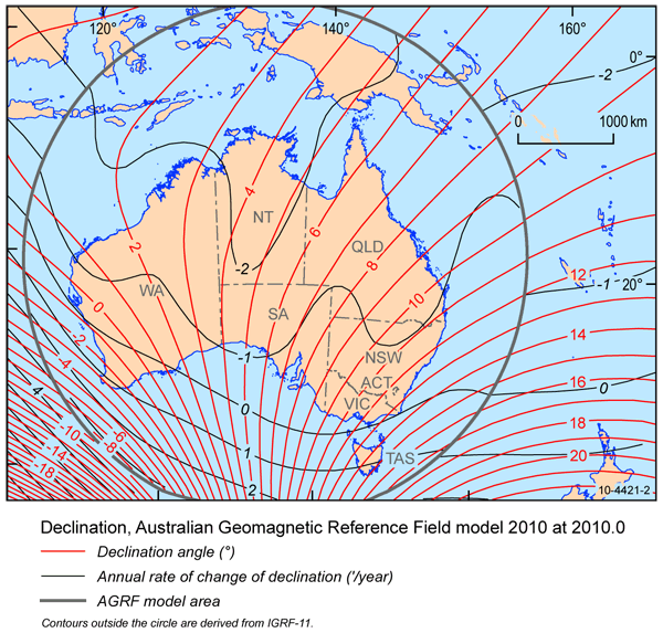
This one uses East and West notation.

It's worth noting that Magnetic declination is constantly changing. You'll notice this if you have a two maps of the same area but produced in different editions. Near the legend there should always be North arrows for both grid and magnetic.
This map gives some indication of what the rest of the world does.
http://www.solarpathfinder.com/images/spf/magdec-world-big.jpg
So does this one
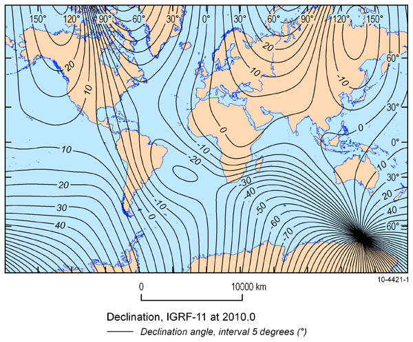
If you wish to accurately know what is it is in your local area try this http://www.ga.gov.au/oracle/geomag/agrfform.jsp
Also if you want to know more. Wikipedia has some good info. http://en.wikipedia.org/wiki/Magnetic_declination
The following two maps show the same information but presented differently.
This uses Positive and negative numbers.
This one uses East and West notation.
It's worth noting that Magnetic declination is constantly changing. You'll notice this if you have a two maps of the same area but produced in different editions. Near the legend there should always be North arrows for both grid and magnetic.
This map gives some indication of what the rest of the world does.
http://www.solarpathfinder.com/images/spf/magdec-world-big.jpg
So does this one
If you wish to accurately know what is it is in your local area try this http://www.ga.gov.au/oracle/geomag/agrfform.jsp
Also if you want to know more. Wikipedia has some good info. http://en.wikipedia.org/wiki/Magnetic_declination
- Gusto
- Athrotaxis cupressoides
- Posts: 375
- Joined: Wed 21 Sep, 2011 10:35 pm
- Region: Victoria
- Gender: Male
Re: Why am i 12 Degrees off???
![]() by ninjapuppet » Sat 25 Feb, 2012 10:16 am
by ninjapuppet » Sat 25 Feb, 2012 10:16 am
wander wrote:That bubble would be a fault in the compass, return it for a warrantee replacement. Take a photo of the bubble noting the elevation and include with the compass to explain the problem. Silva Australia sent our compass back to us because there was no bubble in it (at sea level) and they could not understand our problem until we did this.
Found this on the silva website. I have noticed that it remains accurate with the bubble, so i'm not too worried. ... (yet)
this is direct from their website:
http://www.silvacompass.com/detail.aspx?id=76#4
My Silva compass has a bubble in the fluid. What should I do?
We intend that our compasses are free of bubbles; however, if a small bubble forms in the liquid-filled capsule, it has no influence on the accuracy of the compass. Its appearance and disappearance are due to changes in temperature and atmospheric pressure. If a bubble larger than 1/4" in diameter appears, it is probably the result of a leaking capsule, usually caused by some form of shock damage, and the capsule will have to be replaced. In that case, just call our customer satisfaction department for a return authorization number and shipping address. From the U.S.A, call 1-800-572-8822 between 8 am-6 pm, eastern time. From Canada, call 1-800-263-6390.
-
ninjapuppet - Athrotaxis selaginoides
- Posts: 1225
- Joined: Mon 09 Nov, 2009 11:33 pm
- Region: New Zealand
- Gender: Male
Re: Why am i 12 Degrees off???
![]() by durks » Sat 25 Feb, 2012 8:35 pm
by durks » Sat 25 Feb, 2012 8:35 pm
All Silva compasses seem to develop bubbles with age - and the bubble will grow, shrink, or even disappear depending on atmospheric pressure or altitude. Provided the bubble doesn't get too big, it doesn't interfere with accuracy, *provided* the compass needle is correctly compensated for magnetic dip. I.e. provided you're using the compass in the region of the earth it's been calibrated for.
What you definitely want to avoid doing is using a compass which has a bubble, in a region of the earth for which the compass hasn't been calibrated: the combination of having to tilt the baseplate to deal with the magnetic dip, and the corresponding movement of the bubble (and its physical interference with the 'high' end of the needle) is a recipe for utter frustration and badly inaccurate compass readings. In case you can't guess: I've had the experience!
What you definitely want to avoid doing is using a compass which has a bubble, in a region of the earth for which the compass hasn't been calibrated: the combination of having to tilt the baseplate to deal with the magnetic dip, and the corresponding movement of the bubble (and its physical interference with the 'high' end of the needle) is a recipe for utter frustration and badly inaccurate compass readings. In case you can't guess: I've had the experience!
- durks
- Athrotaxis cupressoides
- Posts: 132
- Joined: Mon 11 Jan, 2010 8:43 pm
- Location: Scotland
- Region: Other Country
Re: Why am i 12 Degrees off???
![]() by phan_TOM » Wed 29 Feb, 2012 12:28 pm
by phan_TOM » Wed 29 Feb, 2012 12:28 pm
If anyones still confused as to the actual process of converting GMA or MGA heres a couple of examples taken from the map reading handbook, might help to visualise it in another way
Not for me, I find mnenomics great for learning different things and once you practice anything long enough it usually sticks anyway. I use the car variation when converting bearings, its easy for me to remember MG's are good (+) and GM is crap (-)... but I remember mnemonics from school, the navy, uni biology, chemistry, geology, music etc etc
edit:
Yes but in this region magnetic north only moves west by less than 0.01° per annum, less than 0.1° every decade or less than 1° every century so not really a concern for bushwalkers
- Conversion of bearings (easterly variation)
- Conversion of bearings (westerly variation)
- back bearings
Gusto wrote:Teaching simple tricks/rules can be confusing
Not for me, I find mnenomics great for learning different things and once you practice anything long enough it usually sticks anyway. I use the car variation when converting bearings, its easy for me to remember MG's are good (+) and GM is crap (-)... but I remember mnemonics from school, the navy, uni biology, chemistry, geology, music etc etc
edit:
Gusto wrote:It's worth noting that Magnetic declination is constantly changing
Yes but in this region magnetic north only moves west by less than 0.01° per annum, less than 0.1° every decade or less than 1° every century so not really a concern for bushwalkers
ALWAYS be yourself.
Unless you can be outside, then ALWAYS be outside.
Unless you can be outside, then ALWAYS be outside.
-

phan_TOM - Phyllocladus aspleniifolius
- Posts: 651
- Joined: Sat 21 Aug, 2010 5:27 pm
- Region: New South Wales
- Gender: Male
Re: Why am i 12 Degrees off???
![]() by South_Aussie_Hiker » Wed 29 Feb, 2012 1:21 pm
by South_Aussie_Hiker » Wed 29 Feb, 2012 1:21 pm
Teaching simple tricks/rules can be confusing
Yeah, I don't really get this either. I don't understand how:
Variation east, magnetic least and variation west, magnetic best
could possibly be confusing or result in additions the wrong way. The comment of it not working in different parts of the world is bollocks. The only thing you need to understand is that maps are true and compasses are magnetic - and I don't think any adult would get this wrong - we all know a compass is a magnet!
Some examples
Your map shows a direction of 135 degrees to your destination and the variation is 10 degrees west - since the map is true, and remembering variation west magnetic BEST, 135T is 145M on your compass
Your compass shows a bearing of 280 to a summit, the variation is 5 degrees east and you wish to plot it on your map - since the compass reading is magnetic, and variation east magnetic LEAST, 280M is 285T on your map.
The mnemonic works if you are taking compass readings and plotting on a map, or vice versa, in any part of the world. It's not that hard.
-
South_Aussie_Hiker - Phyllocladus aspleniifolius
- Posts: 906
- Joined: Tue 22 Feb, 2011 9:24 pm
- Region: South Australia
- Gender: Male
Re: Why am i 12 Degrees off???
![]() by durks » Wed 29 Feb, 2012 8:25 pm
by durks » Wed 29 Feb, 2012 8:25 pm
South_Aussie_Hiker wrote:I don't understand how:
Variation east, magnetic least and variation west, magnetic best
could possibly be confusing or result in additions the wrong way.
Some examples
Your map shows a direction of 135 degrees to your destination and the variation is 10 degrees west - since the map is true, and remembering variation west magnetic BEST, 135T is 145M on your compass
The possibility for confusion comes from the fact that the necessary addition/subtraction is reversed, depending on whether you're going from map to field, or from field to map. (By 'addition/subtraction' in this context I mean the actual mechanical adjustment of the standard Silva-style orienteering compass.) So, in your example:
o Map to field: the map gives a bearing of 135 grid - so I mechanically *add* 10 to the compass dial so that the compass points the correct direction in the field.
o Field to map: I take a field bearing of 145 magnetic - so I mechanically *subtract* 10 from the compass dial so that the bearing on the compass (now being used as a protractor) correctly matches the grid bearings of the map.
If you know what you're doing then you won't go wrong, but if someone simply learns a mnemonic without understanding why then there is a possibility that they could get confused.
Personally, I don't find the mnemonics for this of any value - but each to his own.
- durks
- Athrotaxis cupressoides
- Posts: 132
- Joined: Mon 11 Jan, 2010 8:43 pm
- Location: Scotland
- Region: Other Country
Re: Why am i 12 Degrees off???
![]() by South_Aussie_Hiker » Wed 29 Feb, 2012 9:02 pm
by South_Aussie_Hiker » Wed 29 Feb, 2012 9:02 pm
The possibility for confusion comes from the fact that the necessary addition/subtraction is reversed
I understand what you are trying to say and I do know some people prefer to see things in front of them, but the beauty of this technique is it takes the field to map or map to field argument out of it - it doesn't matter.
I guess as long as we each find our own way that works that's all that matters!
-
South_Aussie_Hiker - Phyllocladus aspleniifolius
- Posts: 906
- Joined: Tue 22 Feb, 2011 9:24 pm
- Region: South Australia
- Gender: Male
Re: Why am i 12 Degrees off???
![]() by climbingone » Thu 24 May, 2012 9:45 pm
by climbingone » Thu 24 May, 2012 9:45 pm
what I do is draw magnetic north lines on my map before i leave home disregarding the grid north lines, easy to do with a protractor and T square saves time in the bush
climbingone
climbingone
- climbingone
- Nothofagus gunnii
- Posts: 18
- Joined: Fri 13 Jan, 2012 11:54 pm
- Region: Victoria
- Gender: Male
Re: Why am i 12 Degrees off???
![]() by Redtail » Fri 25 May, 2012 2:01 pm
by Redtail » Fri 25 May, 2012 2:01 pm
Reality is that which, when you stop believing in it, doesn't go away. - Philip K. Dick
-
Redtail - Atherosperma moschatum

- Posts: 97
- Joined: Sat 13 Aug, 2011 12:06 am
- Location: West of Perth
- Region: Western Australia
- Gender: Male
Re: Why am i 12 Degrees off???
![]() by Gusto » Sat 26 May, 2012 12:20 am
by Gusto » Sat 26 May, 2012 12:20 am
South_Aussie_Hiker wrote:The possibility for confusion comes from the fact that the necessary addition/subtraction is reversed
I understand what you are trying to say and I do know some people prefer to see things in front of them, but the beauty of this technique is it takes the field to map or map to field argument out of it - it doesn't matter.
I guess as long as we each find our own way that works that's all that matters!
The reason I'd rather promote the actual core concept rather than promoting a simple trick rule is because all the rules suggested previously in this thread have been wrong are with the exception of South Aussie Hikers. Yes, some of these suggested rules work in some locations. But unless they work in all locations they are simply wrong. Only teaching someone a rule like those suggested would mean you are teaching people the wrong thing. If a simple trick or phrases is misinterpreted or forgotten then it is difficult to work out what it should be. Where as if people understand how to interpret the information presented on a map properly then they can't forget what to do.
abceight wrote:
The trick that I should have used was "Grand-ma sucks". or "Grid to Magnetic Subtract". I added by mistake.
alanoutgear wrote:GrandMother Sucks - Grid to Magnetic subtract - now that's brought back some memories from National Service in the early '70s. The corrollary is MGA (the car) - Magnetic to Grid add. Used GMS a few weeks ago going across the Tassie central plateau and on to Lake Antimony - worked a treat and navigated to within a few metres of Hut 5. Thank you Sgt Kanga Griffiths - I wonder where you are now?
South_Aussie_Hiker wrote:In aviation we use:
Variation East - Magnetic least
Variation West - Magnetic best
Might mean when you bushwalk overseas where magnetic variation is west, you won't adjust the wrong way!
Gippsmick wrote:Our method is "Crucial Mapping Advice" or CMA.
Compass to Map = Add.
In reverse Map to Compass = Subtract.
blacksheep wrote:my car method- magnetic to grid north/ grid to magnetic..
MG + (good)
GM - (bad)
never forget that one!
- Gusto
- Athrotaxis cupressoides
- Posts: 375
- Joined: Wed 21 Sep, 2011 10:35 pm
- Region: Victoria
- Gender: Male
Re: Why am i 12 Degrees off???
![]() by Rob A » Sat 26 May, 2012 10:26 am
by Rob A » Sat 26 May, 2012 10:26 am
-32 x5/9. *&%$#! cold right now though.
Every four seconds, somewhere in the world, an Harlequin Mills and Boon is sold ... Wot ...
- Rob A
- Phyllocladus aspleniifolius
- Posts: 506
- Joined: Mon 29 Nov, 2010 2:01 pm
- Region: New South Wales
- Gender: Male
Re: Why am i 12 Degrees off???
![]() by darsenator » Thu 18 Sep, 2014 10:13 am
by darsenator » Thu 18 Sep, 2014 10:13 am
doogs wrote:yegdod1 wrote:ILUVSWTAS wrote:Hahaha wow, this is awesome!! I CAN use a compass (somewhat) if i must, just find it so much easier to use the GPS....
Gotta learn somehow..
Be careful if you go to the Northern hemisphere as you need to add the degrees there!!
Hi Doogs....when you say about adding the degrees in the northern hemisphere...what exactly do you mean?
- darsenator
- Nothofagus gunnii
- Posts: 23
- Joined: Fri 07 Dec, 2012 2:58 pm
- Region: Victoria
- Gender: Male
Re: Why am i 12 Degrees off???
![]() by GPSGuided » Thu 18 Sep, 2014 10:28 am
by GPSGuided » Thu 18 Sep, 2014 10:28 am
darsenator wrote:Hi Doogs....when you say about adding the degrees in the northern hemisphere...what exactly do you mean?
Doog went to the US of A.
Just move it!
-

GPSGuided - Lagarostrobos franklinii
- Posts: 6801
- Joined: Mon 13 May, 2013 2:37 pm
- Location: Sydney
- Region: New South Wales
Re: Why am i 12 Degrees off???
![]() by darsenator » Thu 18 Sep, 2014 3:41 pm
by darsenator » Thu 18 Sep, 2014 3:41 pm
GPSGuided wrote:darsenator wrote:Hi Doogs....when you say about adding the degrees in the northern hemisphere...what exactly do you mean?
Doog went to the US of A.
But converting between magnetic to grid and grid to magnetic should use the same formula from a east(positive) declination , if in fact ones region lies within a east-declination isogonic line (no matter which hemisphere the location is in) ?
- darsenator
- Nothofagus gunnii
- Posts: 23
- Joined: Fri 07 Dec, 2012 2:58 pm
- Region: Victoria
- Gender: Male
33 posts
• Page 1 of 2 • 1, 2
Return to Bushwalking Discussion
Who is online
Users browsing this forum: No registered users and 59 guests