Kalkite Mountain via Botherum Plain - Something for everyone

Trip reports, stories, track notes. Multiple/large photos are OK in this forum.
Forum rules
Posting large/multiple images in this forum is OK. Please start topic titles with the name of the location or track.

For topics focussed on photos rather than the trip, please consider posting in the 'Gallery' forum instead.

This forum is for posting information about trips you have done, not for requesting information about a track or area.

Kalkite Mountain via Botherum Plain - Something for everyone

Postby johnw » Sat 11 Feb, 2012 11:31 am

We did this day trip back at the end of 2006. There was some interest in this walk resulting from this topic a while back. So I thought I'd write a trip report and share a few photos. It seems to be a less frequently visited or well known part of Kosciuszko NP. To some extent, fly fishermen rather than bushwalkers appear to inhabit this part of the world. I had done some research on the walk in advance as there wasn't much public information available. I ended up ringing the NPWS ranger for the area, mainly about road access to the track head. The information I had found indicated only one route in, from the north via the Nimmo Road. I was advised that a high clearance 4WD was recommended, unless prepared to park further away and undertake a much longer walk. I had a suitable 4WD so no problem.

The drive in wasn't too bad in the XJ series Jeep Cherokee that I owned at the time. A few rutted out, steep sections and water bars where the extra clearance was appreciated but nothing difficult. I suspect that a lot of soft roaders can be driven in here with care, and maybe the odd 2WD with good clearance (and/or that isn't a prized possession). To get to the start I used instructions from http://www.pbase.com/bookster/kalkmtn which has some good info and photos. Basically, just take the Eucumbene Rd north of Jindabyne, left onto Nimmo Rd, which eventually joins the Island Bend Fire Trail. Follow this to the camp site at the Gungarlin River. While it would possibly seem easier to approach from Island Bend, I don't think it can be done (unless on foot). From memory, unless things have since changed, a permanently locked gate blocks vehicle access somewhere along that side.

The walk starts at the camp site near the bridge on the Gungarlin River, just on the edge of the Botherum Plain. This was at the end of December and it was a popular place. Numerous vehicles were camped there. It's a public site managed by the NPWS and has a pit toilet. Most of the people car camping there appeared to be fly fishing. The walk from the camp site to Kalkite Mountain summit is not too difficult for experienced walkers. Across the Botherum Plain it’s old fire trail, with a shallow crossing of the Gungarlin on the way. Distance is about 14km return, but includes roughly 3 km off track (each way) from Kalkite Gap. Elevation gain is around 250m. It's not difficult off track (steep-ish, of course) but there's a bit of navigation and you need to avoid being confused by brumby tracks.

From the bridge we commenced the walk SE along the old fire trail across the Botherum Plain, which makes up the bulk of the total walk distance of about 14 km return. This part is easy going. We knew that the Botherum Plain Hut was located along here, off the trail somewhat, but didn't sight it on the way out. We continued along the trail and made a shallow crossing of the Gungarlin River at a very pretty spot.
Gungarlin River Crossing.jpg
Gungarlin River Crossing

We continued along the trail to the location known as Kalkite Gap, indicated by the presence of Kalkite Rock, a solitary, large round boulder on the plain. This was the point at which we needed head off-track and navigate up to the mountain summit. The initial ENE uphill climb revealed brumby tracks everywhere. If you do this walk don't be fooled by them, although some were handy to follow briefly (i.e. those that were heading generally in the right direction). We aimed for the saddle between Kalkite Mountain and the unnamed hill to its NW. From here it was reasonably easy to spot the route up the rest of the mountain. A lot of earlier fire damage was evident as we made the fairly steep ascent of Kalkite Mountain itself.
Creamy Yellow Bottlebrush spp. on Kalkite Mtn.jpg
Creamy Yellow Bottlebrush spp. on Kalkite Mountain

Lake Jindabyne from Kalkite Mtn.jpg
Lake Jindabyne from near the trig

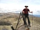
Nearing 1550m ASL Kalkite Mountain won't win any prizes for altitude when compared with its taller brethren on the main range nearby. But you'd be forgiven for thinking differently once on top. Well, not quite on top as the true summit is a large rock slab surrounded by trees and you can't see anything from that. But the summit is only a few metres higher than its immediate surrounds anyway. The views are from an eyrie near the trig station just to the NE of the true summit. Breathtaking views over Lake Jindabyne and across it to the small settlements of Kalkite and East Jindabyne, with Jindabyne township itself and parts of the main range in the distance.
Main Range from Kalkite Mtn.jpg
Towards the Main Range

Jindabyne from Kalkite Mtn.jpg
Jindabyne in the distance
John W

In Nature's keeping they are safe, but through the agency of man destruction is making rapid progress - John Muir c1912
User avatar
johnw
Lagarostrobos franklinii
 
Posts: 9026
Joined: Wed 23 Jan, 2008 11:59 am
Location: Macarthur Region - SW Sydney
Region: New South Wales
Gender: Male

Re: Kalkite Mountain via Botherum Plain - Something for ever

Postby johnw » Sat 11 Feb, 2012 11:50 am

During the customary lunch break I started thinking – always a little dangerous. My thoughts involved hatching a plan that would give us a quick descent back to the trail, which I had spotted far below, rather than retrace our steps. How hard could it be? After scrub bashing down to the point of no return through rampant post-fire regrowth, and tripping over numerous hidden fallen logs, I found out how hard and decided not to be so clever in the future. Anyway we eventually made it back to the trail with a sigh of relief.
Botherum Plain.jpg
The scenic Botherum Plain

A further bit of excitement was still to come. I've read descriptions of the Botherum Plain area that say things like "beautiful, remote lonely place" and I'd have to agree. We had a very up close encounter with brumbies on the return walk, getting a little too close and received some unsettling attention from a stallion before they all turned in unison and stampeded in the opposite direction. The brumby encounter was unnerving. We got quite close while taking photos of them and my son insisted on trying to get even closer. The stallion left the others and faced us, snorting, in what I assumed to be some type of aggressive threat display. I suggested we back away (like right now), and we did. That's when they all about turned and charged off flat chat. I know that they're feral and an ongoing problem, particularly if they get up into the alpine zone, but this was quite a spectacle and experience. Now I know why I still enjoy those 1980s Man from Snowy River movies and the classic Banjo Paterson poem.
Unhappy brumbies.jpg
The brumbies seem a little angry at our presence

Brumbies in flight.jpg
And they stampede across the plain

The spartan but functional Botherum Plain Hut (aka Willis Hut) dates from 1962 is about 1 km from the start. It is worth a visit in either direction but is well off track and not easily seen on the outward leg, so better done on the way back. For more information see the relevant page on the KHA site. It has some interesting historical links with other huts and locations.
Outside Botherum Plain Hut.jpg
Botherum Plain Hut

Inside Botherum Plain Hut.jpg
The salubrious interior of the hut

I recommend this walk if you want something a little out of the way and have a day to spare. I think the walk took around 5 hours, possibly slightly more, due to my "short cut" directly west down the mountain rather than simply reversing the ascent route (which would be the preferred option).
Brumby photos courtesy Andrew W, all others by the author.
John W

In Nature's keeping they are safe, but through the agency of man destruction is making rapid progress - John Muir c1912
User avatar
johnw
Lagarostrobos franklinii
 
Posts: 9026
Joined: Wed 23 Jan, 2008 11:59 am
Location: Macarthur Region - SW Sydney
Region: New South Wales
Gender: Male

Re: Kalkite Mountain via Botherum Plain - Something for ever

Postby climberman » Sun 12 Feb, 2012 6:38 am

Nice John. I spent four days three nights fishing from the Nimmo Rd (north of the Island Bend FT), down to the aquaduct that takes the G across the hills, up onto the Burrungabugee and over to the G again. Lovely area. Camped on Botherum Plain I think near where your 'scenic Botherum Plain' photo is, for a night. Lovely area. Yes, popular with fly anglers. You can access IB FT both ways via mountain bike too. Eucumbene to Jindabyne via the IB FT is a good day out of around 60k's, and you finish at the pub ! Access from below via Snowy Adit.
climberman
Phyllocladus aspleniifolius
 
Posts: 656
Joined: Tue 09 Dec, 2008 7:32 pm

Re: Kalkite Mountain via Botherum Plain - Something for ever

Postby johnw » Sun 12 Feb, 2012 11:22 pm

climberman wrote:Nice John. I spent four days three nights fishing from the Nimmo Rd (north of the Island Bend FT), down to the aquaduct that takes the G across the hills, up onto the Burrungabugee and over to the G again. Lovely area. Camped on Botherum Plain I think near where your 'scenic Botherum Plain' photo is, for a night. Lovely area. Yes, popular with fly anglers. You can access IB FT both ways via mountain bike too. Eucumbene to Jindabyne via the IB FT is a good day out of around 60k's, and you finish at the pub ! Access from below via Snowy Adit.

Thanks climberman. Yes everyone seemed to be fishing. The MTB idea sounds good, I'll have to take mine next time I go down there. We were in Jindabyne again over the Xmas break (ironically rented an apartment just across the road from the pub :)).
John W

In Nature's keeping they are safe, but through the agency of man destruction is making rapid progress - John Muir c1912
User avatar
johnw
Lagarostrobos franklinii
 
Posts: 9026
Joined: Wed 23 Jan, 2008 11:59 am
Location: Macarthur Region - SW Sydney
Region: New South Wales
Gender: Male

Re: Kalkite Mountain via Botherum Plain - Something for ever

Postby Drummo62 » Mon 07 Dec, 2015 12:53 pm

I am heading up to Jindabyne over the Christmas/New Year period and as we are staying at Kalkite thought I might have a look at this day trip. Has anyone been up that way recently and can comment on the track conditions particularly the road in? Previous comments from this and another thread suggest I should be ok to get to the trail head in my Subaru Outback but some up to date intel would be great. Thank you.
User avatar
Drummo62
Atherosperma moschatum
 
Posts: 95
Joined: Wed 12 Mar, 2014 12:05 pm
Region: Victoria
Gender: Male

Re: Kalkite Mountain via Botherum Plain - Something for ever

Postby johnrs » Thu 10 Dec, 2015 4:49 pm

Drummo
The road was fine this winter
John
johnrs
Phyllocladus aspleniifolius
 
Posts: 621
Joined: Mon 09 Aug, 2010 6:09 pm
Region: New South Wales

Re: Kalkite Mountain via Botherum Plain - Something for ever

Postby Drummo62 » Thu 10 Dec, 2015 8:07 pm

Cheers John
User avatar
Drummo62
Atherosperma moschatum
 
Posts: 95
Joined: Wed 12 Mar, 2014 12:05 pm
Region: Victoria
Gender: Male


Return to NSW & ACT Trip Reports & Track Notes

Who is online

Users browsing this forum: No registered users and 8 guests