Between Christmas and New Year I like to try and get away and this year I decided to head south to the Northern Kosciuszko area. After a 5 hour drive from Sydney I parked near the head of the Yaouk Valley north of Adaminaby. It was a 5:40PM when I slung my pack onto my shoulders and set off under leaden skies. I hadn't gone far and it started raining; lightly at first and then heavier. To save weight I'd only brought my light spray jacket and before long I was soaked; as much from perspiartion as anything as I trudged up the steep Lone Pine Trail. After a couple of false tops I arrived at the saddle below Mt Morgan. There a new Bimberi wilderness sign warned me that because I was entering a wilderness area there would be no signs? Down the other side I dropped into the headwaters of the Goodradigbee River which flows virtually due north for most of its length to the Burrinjuck Resevoir. The going here was quite pretty with several grassy flats and groves of gum trees with the infant river winding its path through. Just as it was getting on dark I emerged onto the largest flat so far and Murrays Gap FT and the AAWT came in on my right and up ahead on the side of the hill I could make out Oldfields Hut, my destination for the night, in the gloom. There was one other walker in occupation, Jerry from Melbourne who was walking the AAWT. From the hut log book it would seem this is a very popular thing to do. Those walking from south to north are only a couple of days from finishing by the time they reach here. Most were taking between 30 and 40 days to come this far. Quite a trek. Oldfields is also on the BNT which actually comes in on the Lone Pine Trail that I had taken. Even longer it stretches all the way from Cooktown to Healsville. Designed for horseriders but popular also with bike riders there were some interesting entries from them to. One from a 14 yo old girl who had been riding with her family south from Cooktown. they had been on the trail 14 months! As it was late I quickly got a small fire going and cooked dinner before hitting the sack. Soon the pleasant sound of rain on the old tin roof lulled me off to sleep. It wasn't long though before the not so pleasant sound of possums scurrying around the room awoke me with a start. I had intended to leave a food drop here to be collected on my way out but they had already eaten into it! I repacked my food and slung it from a hook in the ceiling and tried to get back to sleep.
TBC.
Tantangara Trundle
Forum rules
Posting large/multiple images in this forum is OK. Please start topic titles with the name of the location or track.
For topics focussed on photos rather than the trip, please consider posting in the 'Gallery' forum instead.
This forum is for posting information about trips you have done, not for requesting information about a track or area.
21 posts
• Page 1 of 1
Tantangara Trundle
![]() by kanangra » Fri 06 Jan, 2012 8:00 am
by kanangra » Fri 06 Jan, 2012 8:00 am
- kanangra
- Athrotaxis selaginoides

- Posts: 1335
- Joined: Sun 25 May, 2008 3:52 pm
Re: Tantangara Trundle
![]() by kanangra » Fri 06 Jan, 2012 5:08 pm
by kanangra » Fri 06 Jan, 2012 5:08 pm
Day 2. 28th Dec. 2011. After wiping the possom *&^%$#! off my gear I was up and away by 7. Note to self next time bring a tent and even if its raining pitch it outside on the lawn instead of waking every 10 minutes ( at least that's what it felt like ) to shoo away the possums. Instead of following the track I decided to follow the river downstream. This worked for a while but before long it began to close in so I started climbing. On top of the spur I expected to cut the road but instead I hit nothing but head high scrub. So down the other side and up again through more scrub and this time I cut the road which I followed back down to the river at the inlet weir. Here water from the Goodradigbee is diverted by means of a tunnel 3.5k long into the catchment of the Tantangara Resevoir which is all part of the Snowy Mts. scheme. After the recent rains there was quite a flow of water being diverted. I had breakfast sitting on top of the gantry above the weir. I then followed the aqueduct road around to Pockets Saddle. This was quite worthwhile because it afforded quite good views of the river which flows through a small gorge complete with a nice waterfall. Once at the saddle I took the Leura Gap trail and crossed over to Pocket Hut. This is a very neat and tidy hut with at least 4 rooms and a roomy verandah. If you prefer camping the lawn outside is excellent. After leaving the hut I rejoin the AAWT which I follow up to Seventeen Flat which is very pleasant going. I decide to drop the pack and set off on a tour of Cooleman Plain. First stop Bill Jones Hut which is fairly basic and one of the few with only an earth floor. Next I set off in search of Harris Hut but all I can locate is some old ruins. Very little left there now and certainly no shelter. I strike off across country and see the Harris waterhole in the distance before cutting the Blue Waterholes FT which I follow into Coolamine Homestead. A great restoration job has been done here. I note that the metal axle of the wooden cart rotting in the top paddock is stamped with the date 1904. This relic was new a little over 100 years ago. I had no sooner left the shelter of the old homestead than the grey clouds rolled in and several thunder claps announced the onset of a heavy downpour. I trudged on down the tourist road finding shelter under a tent awning in the camp ground at the end. I shivered there for about 45 mins waiting for the storm to pass ( I had left my gear in the pack ) before deciding there was nothing for it but to press on. I found Cave Ck a raging torrent over knee deep. I crossed only to find I had to cross again and then again before the rushing waters were behind me. The track itself became swirling stream of water as I made my way out of the valley. At last the rain eased and the clouds began to lift just as I completed the circuit and pulled my spray jacket out of the pack. It was nearly 3:00PM. Time for lunch. I was surprised how hungry I felt. The Christmas ham tasted better out there in the middle of Cooleman Plain than it had at home on Christmas Day.
TBC
TBC
- kanangra
- Athrotaxis selaginoides
- Posts: 1335
- Joined: Sun 25 May, 2008 3:52 pm
Re: Tantangara Trundle
![]() by kanangra » Sat 07 Jan, 2012 9:02 am
by kanangra » Sat 07 Jan, 2012 9:02 am
After lunch I continued on through the Blue Waterhole Saddle, disturbing a large mob of brumbies as I went. I thought about spending the night at Old Currango which I could see from the track off in the distance, but as the weather had brightened I decided to continue on. The track wound up along Mosquito Ck and over Harrys Gap under Tom O'Rourkes Peak onto the eastern fringe of Long Plain with the infant Murrumbidgee River winding its way through. It was very pleasant going in the evening glow and I thought about stopping for the night several times on the beautiful grassy fields beside the track but then I saw a beautiful creek gurgling through an alpine meadow. I wandered upstream over a hill and there was Hainsworth Hut on the banks of Dip Ck surrounded by a manicured lawn and plenty of firewood. I whipped my shoes off and rubbed my hot feet on the cool grass before plunging into the creek. Ah very refreshing. Soon dinner was underway on an open fire as the setting sun illuminated the snow gum lined hills opposite. What a splendid aspect. I decided to camp out on the hut lawn where I could make a run for cover if I needed to. But I didn't have to worry, it was a beautiful clear dark night. It had been too long since I laid back looking up at such a starry aray. It doesn't get much better than this.
TBC
TBC
- kanangra
- Athrotaxis selaginoides
- Posts: 1335
- Joined: Sun 25 May, 2008 3:52 pm
Re: Tantangara Trundle
![]() by kanangra » Sat 07 Jan, 2012 10:42 am
by kanangra » Sat 07 Jan, 2012 10:42 am
Day 3 29th Dec 2011. I was up at first light and on my way by 6:00. The morning was cool and clear and so I set off at a brisk pace as much to warm up as anything. Before long I could hear the throb of generators and was quite unprepared for the large crowd of vehicles and horse floats at Ghost Gully Camping ground. No one was stirring when I passed through before 7:00 but there were many horses happily grazing in their elctrified enclosures. Horse riding is very popular in this northern section of the park. I turned right onto the rather strangely named Port Phillip trail and then on the other side of Bally Ck struck out across country for Millers Hut where I had breakfast basking in the early morning sun on a chair from the hut. Oh the little luxuaries. I couldn't locate the old track leaving Millers hut to the south west and so again set off across country aiming to intercept the AAWT. There is no track in this section just a way of route although the old phone line is a navigation aid. I located a pole on top of a rise and followed the line till it crossed an old fence line near a gap with views through to Long plain. After this there were no more poles or markers of any kind but because the weather was good the way was obvious out down and across Dairyman's Ck. On the other side I climbed an open valley to a clear saddle with views down to the Murrumbidgee. After all the recent rain I had been a little apprehensive about the crossing particularly as the hut books recorded accounts of long detours to avoid chest high crossings? I forded readily enough with the water up to mid thigh depth. I also forded the Tantangra Ck. soon after and as I was resting on the far bank a party on horse back came riding up and proceeded to cross without dismounting. It was like a scene straight out of "The Man from Snowy River". I thought how magnificent the horses looked. I followed them up the hill on the other side but they left the track and before long I had the whole place to myself again. The sun was well up now and for the first time it felt quite hot. I topped up my ater at Blanket Plain and was quite happy to get in out of the sun at Witzes Hut for lunch. I decided a long break had been earned and so set all my gear out in the sun to dry as it had been quite a heavy dew overnight. Some of the scraps of newspaper lining the walls were from the late 1800's. But it is quite possible the hut wasn't built till later using materials from an earlier dwelling. Again the hut log book was full of entries from parties walking the length of the AAWT. 33-34 days to get this far from Walhalla in Vic. seemed about the going rate.
TBC.
TBC.
- kanangra
- Athrotaxis selaginoides
- Posts: 1335
- Joined: Sun 25 May, 2008 3:52 pm
Re: Tantangara Trundle
![]() by kanangra » Sat 07 Jan, 2012 2:02 pm
by kanangra » Sat 07 Jan, 2012 2:02 pm
Quite refreshed after the long break I set off and soon recrossed Tantangara Ck. I didn't see any sign of the mine workings on Kiandra Ck as I passed. Up the rise I left the AAWT and followed Alpine Ck. Trail which soon recrosse Tantangara Ck below a waterfall. It then climbed sharply before dropping back down to Boggy Plain. This was perhaps the prettiest plain of them all with outcropping piles of granite boulders dotting the treeless basins through which the creek ran. Near the head of the valley I again struck out across country keeping Blackfellows Hill on my left. On the far side of the plain I picked up a bridle trail which took me up and over to Whares campground where another posse of horseriders was camped. Several kangaroos grazed on the green pick of the campground as I walked through. I was on Tantangara Rd, which is the main drag in these parts, for only about 1k when I turned off onto Scofields trail. At first this wound high above Nungar Ck but then in and out of the timber alongside the expansive Nungar Plain. Just on 6:00PM I rounded a corner and Scofields Hut came into view. Another very neat and tidy hut with a new brick fireplace and chimney. Again I set up camp on the lawn outside with dinner quickly on the go. it had been another long but very rewarding day. Clouds began to roll in and the night, whilst dry, was not as clear as the one before.
TBC.
TBC.
- kanangra
- Athrotaxis selaginoides
- Posts: 1335
- Joined: Sun 25 May, 2008 3:52 pm
Re: Tantangara Trundle
![]() by kanangra » Sat 07 Jan, 2012 4:37 pm
by kanangra » Sat 07 Jan, 2012 4:37 pm
Day 4 30th Dec. 2011. I allowed myseld a sleep in this morning and so wasn't away till 6:15. Before long I passed the turn off to Circuits trail and then the Gulf Ck FT. It was a cool morning and there was a heavy covering of cloud. I pulled into Circuits Hut for breakfast. More like a house than a hut. 5 rooms and lined inside and out. It even comes with an old kerosene fridge! the track continued in the timber on the fringe of the Gulf Plain. Before turning right and going down the Pedens Hut FT I rounded the corner for a view of Tantangar Dam and resevoir. The track crossed the open plain and then Gulf Plain Ck. before winding in and out of the timber. Townsend Hut could be seen on the slopes across the river. I visited Pedens Hut which is used as a base for trips to Half Moon Peak and Mt Morgan. The log book abounded with tall fishing tales and so I headed for the river to take a look. Sure enough there were plenty of trout to be seen. I crossed over and took the Murrumbidgee River Trail up the hill opposite. ( NB the track up Clear ridge leaves on the opposite side of the river crossing Paytens ck not as shown on the Tantangara toppo map. ) It is a staedy pull up the ridge but at the top it takes a sharp left turn and before long joins the Pockets Saddle Rd. which I follow for about 1k to the saddle with height 1375 on the Rules Pt. toppo. Here I pick up a bridle trail which is incorrectly mapped. It actually starts north of the old track into Currango Homestead (which itself is not marked). As it forms part of the BNT this also leads down to another large horse camp which has more the atmosphere of a country gymkana. The bridle trail continues across the creek and eventually comes back out on the Pocket Saddle Rd. just after the gate. Here I catch up on the cricket score. Next it is right onto the Murray Gap FT and then up steeply and over back down to Oldfields Hut. I retrieve my food dump and get stuck into some lunch resting on one of the picnic chairs kindly left at the hut. As I was leaning back gazing up at the range and idea came to me. Why not attempt Bimberi Pk? It was only 2:00PM and I was not due back till tomorrow and the weather was holding? I Quickly I packed up, helping myself to the half used gas cylindar left in the hut, and wandered down to the crossing of the Goodradigbee. Up steeply to Dunns Flat which looks as if it would be an excellent place to camp then up steeply again to Murrays Gap. Here I dropped my pack at the sign and crossed the hanging swamp in the saddle and picked up a cairned route which led up the peak. After about an hour I burst out into the open at an alpine herbfield which gave excellent views straight back down to the hut. Then it was along the open tops to the final haul up to the trig which afforded views in all directions. I could now say I had climbed the highest mountain in the ACT. I was surprised how expansive the tops were. There was an outlier to the west and a lot of upland to the north which appeared to have stream flowing through it. this would be worth a closer look another day. I was back down at the gap at 6:00 and decided to stay there the night. And a delightful evening it was too with a fine sunset.
- kanangra
- Athrotaxis selaginoides
- Posts: 1335
- Joined: Sun 25 May, 2008 3:52 pm
Re: Tantangara Trundle
![]() by kanangra » Sat 07 Jan, 2012 5:09 pm
by kanangra » Sat 07 Jan, 2012 5:09 pm
Day 5 31st Dec. 2011. (final day) I was up at first light and away by 5:45. The descent into the Cotter Valley is long and steep but so much easier than coming the other way. Near the bottom I left the track to cut the corner but succeeded only in cutting my shin on a sharp stick. I bathed it in the clear flowing waters of Jacks Ck where I decided to take breakfast. Rolleys Flats were shrouded in early morning mist when I passed starting the long climb to Yaouk Gap. The hut just on the NSW side of the border is locked and looks privately owned. It is a quick descent to Old Yaouk Ck. and then a walk along the flat to Rowleys Hut which is in off the main track. From here it is along the dead straight Kennedys Rd to the Lone Pine turn off which I take past yet another horse camp to the car. it was 10:00AM.
Although a lot less rugged than usual with clear tracks most of the way I really enjoyed this walk. The country is stunning although I suspect I did see it at its very best after a very wet season. I recommend it strongly to anyone interested in the open high country.
K.
Although a lot less rugged than usual with clear tracks most of the way I really enjoyed this walk. The country is stunning although I suspect I did see it at its very best after a very wet season. I recommend it strongly to anyone interested in the open high country.
K.
- kanangra
- Athrotaxis selaginoides
- Posts: 1335
- Joined: Sun 25 May, 2008 3:52 pm
Re: Tantangara Trundle
![]() by Tony » Sat 07 Jan, 2012 7:00 pm
by Tony » Sat 07 Jan, 2012 7:00 pm
Hi Kanangra,
Thanks for a very excellent and very enjoyable trip report, while I have not walk all of the country you just walked in I have done fair bit of walking in the area and it is top walking country.
I just missed you at Pedens Hut, I spent 1-3rd Jan fishing the Murrumbidgee around Pedens, we saw quite a few horse riders and while I was away fishing, a horse rider rode through our camp and damaged one of my tent guy ropes, I do not know why he or she wanted to get so close to my tent.
Thanks
Tony
There is no such thing as bad weather.....only bad clothing. Norwegian Proverb
-
Tony - Athrotaxis selaginoides
- Posts: 1896
- Joined: Fri 16 May, 2008 1:40 pm
- Location: Canberra
- Region: Australian Capital Territory
Re: Tantangara Trundle
![]() by kanangra » Sat 07 Jan, 2012 8:38 pm
by kanangra » Sat 07 Jan, 2012 8:38 pm
Tony,
Yes we must have just missed each other. How was the fishing? Isn't that river crossing a beautiful place? How did you get in there? Did you do much exploration?
K.
Yes we must have just missed each other. How was the fishing? Isn't that river crossing a beautiful place? How did you get in there? Did you do much exploration?
K.
- kanangra
- Athrotaxis selaginoides
- Posts: 1335
- Joined: Sun 25 May, 2008 3:52 pm
Re: Tantangara Trundle
![]() by Tony » Sat 07 Jan, 2012 8:50 pm
by Tony » Sat 07 Jan, 2012 8:50 pm
kanangra wrote:Tony,
Yes we must have just missed each other. How was the fishing? Isn't that river crossing a beautiful place? How did you get in there? Did you do much exploration?
K.
Hi Kanangra,
The fishing was very good, the whole area is very beautiful, we walked in from just below the Tangtangra Dam wall along Pedens Fire Trail. This trip was just a flyfishing trip, we did not do any thing else, but during winter I did a trip into Circuits Hut, we had a great night in front of the fire place.
Just as we where leaving Pedens Hut a work crew from the P&WS turned up to start to put some new foundations on the hut, they with the help of KHA are going to put a steel base and new concrete surround on the hut, I hope they keep the old wooden floor, this should help preserve the hut for future generations.
Tony
There is no such thing as bad weather.....only bad clothing. Norwegian Proverb
-
Tony - Athrotaxis selaginoides
- Posts: 1896
- Joined: Fri 16 May, 2008 1:40 pm
- Location: Canberra
- Region: Australian Capital Territory
Re: Tantangara Trundle
![]() by north-north-west » Wed 11 Jan, 2012 7:02 pm
by north-north-west » Wed 11 Jan, 2012 7:02 pm
You didn't go up Morgan? shame on you, it's a wonderful little mountain.
"Mit der Dummheit kämpfen Götter selbst vergebens."
-

north-north-west - Lagarostrobos franklinii

- Posts: 15119
- Joined: Thu 14 May, 2009 7:36 pm
- Location: The Asylum
- ASSOCIATED ORGANISATIONS: Social Misfits Anonymous
- Region: Tasmania
Re: Tantangara Trundle
![]() by north-north-west » Thu 12 Jan, 2012 5:29 pm
by north-north-west » Thu 12 Jan, 2012 5:29 pm
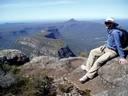
Well, this is the view to the south, all the way past Jagungal to the Main Range (it isn't always this foggy):
Or you could look north, over Murray and Bimberi:
Good views east over much of Namadgi and west over the Cooleman Plains as well. There's a pad that leads up from the horse camp. It gets a bit faint at one point when it passes through a section of treefalls, but gets clearer again above that. It also continues along the ridge northwards. You can actually follow that ridge all the way back tot he FT above Oldfields, although it gets a bit scrubby in places.
"Mit der Dummheit kämpfen Götter selbst vergebens."
-
north-north-west - Lagarostrobos franklinii
- Posts: 15119
- Joined: Thu 14 May, 2009 7:36 pm
- Location: The Asylum
- ASSOCIATED ORGANISATIONS: Social Misfits Anonymous
- Region: Tasmania
Re: Tantangara Trundle
![]() by kanangra » Fri 13 Jan, 2012 8:56 am
by kanangra » Fri 13 Jan, 2012 8:56 am
Thanks for those photos NNW they are great. Now I just know I have to get up there. I wondered about the best approach and the route up the ridge sounds good. I didn't notice the track from the horse camp but then I wasn't aware it was there and so wasn't really lookung for it. Next time I am down that way It is definitely on my agenda.
K.
K.
- kanangra
- Athrotaxis selaginoides
- Posts: 1335
- Joined: Sun 25 May, 2008 3:52 pm
Re: Tantangara Trundle
![]() by north-north-west » Fri 20 Jan, 2012 6:36 pm
by north-north-west » Fri 20 Jan, 2012 6:36 pm
Errrm, I mean the horse camp near the Bimberi Wilderness sign, not the one at the base of the Lone Pine Trail. Turn left at the sign and follow the wheel ruts in through the boggy bits until it heads into a bit of open forest. Footpad from there; the camping areas not far in. Good camping although the water from the pools is a bit suss - you can cook with it but I've never been game to drink it.
"Mit der Dummheit kämpfen Götter selbst vergebens."
-
north-north-west - Lagarostrobos franklinii
- Posts: 15119
- Joined: Thu 14 May, 2009 7:36 pm
- Location: The Asylum
- ASSOCIATED ORGANISATIONS: Social Misfits Anonymous
- Region: Tasmania
Re: Tantangara Trundle
![]() by kanangra » Mon 23 Jan, 2012 11:47 am
by kanangra » Mon 23 Jan, 2012 11:47 am
Thank you for that. I know exactly where you mean. I walked in a short way there through the grass and wondered? Very helpful to know that is the way. I hope to get back there and will give it a try.
K
K
- kanangra
- Athrotaxis selaginoides
- Posts: 1335
- Joined: Sun 25 May, 2008 3:52 pm
Re: Tantangara Trundle
![]() by kanangra » Tue 05 Jun, 2012 10:36 am
by kanangra » Tue 05 Jun, 2012 10:36 am
I have decided that it is time I tried to post a photo so here goes.
This was taken at Coolamine Homestead
- kanangra
- Athrotaxis selaginoides
- Posts: 1335
- Joined: Sun 25 May, 2008 3:52 pm
Re: Tantangara Trundle
![]() by kanangra » Tue 05 Jun, 2012 10:38 am
by kanangra » Tue 05 Jun, 2012 10:38 am
Oh and another thing I found stamped on the iron axle the year of manufacture, 1910!!!! Yes just on 100 years ago men were still making these!
K.
K.
- kanangra
- Athrotaxis selaginoides
- Posts: 1335
- Joined: Sun 25 May, 2008 3:52 pm
Re: Tantangara Trundle
![]() by kanangra » Tue 05 Jun, 2012 10:41 am
by kanangra » Tue 05 Jun, 2012 10:41 am
This is Bill Jones Hut. It is fairly basic with dirt floor but is in a pleasant setting.
K
K
- kanangra
- Athrotaxis selaginoides
- Posts: 1335
- Joined: Sun 25 May, 2008 3:52 pm
Re: Tantangara Trundle
![]() by kanangra » Mon 22 Jul, 2013 12:04 pm
by kanangra » Mon 22 Jul, 2013 12:04 pm
Well suitably chastened by NNW I put matters to rights last Christmas and climbed Mt Morgan. I did it as a fairly long day walk from Schofields Hut. I was out most of the day and didn't get back till just on dark. Excellent day though. I approached the top the way that NNW suggested and it was a very pleasant climb. The middle of the three tops is the highest but has no trig.
I have written a report elsewhere on this site.
K.
I have written a report elsewhere on this site.
K.
- kanangra
- Athrotaxis selaginoides
- Posts: 1335
- Joined: Sun 25 May, 2008 3:52 pm
21 posts
• Page 1 of 1
Return to NSW & ACT Trip Reports & Track Notes
Who is online
Users browsing this forum: No registered users and 12 guests