Having just reread Jim Smiths book titled “The Lindeman Pass” I am eager to experience the pass for myself. Just to get a taste I walked down Gladstone Pass, along a small section of Lindeman Pass then up Roberts Pass and back to the car.
I left the car at the top of the Fairmont Resort driveway and started walking around 10am. Just down the drive about 50m there is a little turning circle and a small track that runs behind the houses. I noticed a small sign and walked down to check it out. I had stumbled upon the start or the Gladstone Pass. Jims book had described the start or the track further down near some sheds out the back of the Fairmont, so I was glad that things were going my way right from the start. The track looked very overgrown and it had been raining so I stopped and got my parka on before I soaked myself to the core.
Once on the Gladstone Pass it’s quite easy to follow but in some places its been washed out with small landslides and a slippery scramble is required. Pretty soon I was covered in mud and enjoying every bit of it. All I had to do was keep the thought of leeches out of my mind. No sense in worrying about something you can do little about. I had DEET around my legs. What more can you do. Not long into the walk I hit the creek and followed it down through the gorge. I have a gps in my pack with an external antenna that I use to track where I go and through this gorge I new it wouldn’t get reception. It’s very narrow and quite steep. It was originally and access route to the Gladstone Colliery that was mined from 1885 to 1886. I can’t imagine having to walk in and out of this gorge every day for work. They built em tough in those days. About halfway down I came to the miners steps that they had carved out of the rock. I was glad that someone has placed a rope down the side to hold onto. In places they are very wet, slippery and narrow, and a slip here could hurt a great deal. Just over an hours decent I had reached the intersection of the Lindeman Pass. I had to back track a little as I didn’t notice it and kept heading down the gully. Realising that I had lost the track I headed back up the hill and found the track hugging the base of the cliff. It was a good feeling being on Lindeman Pass even though it was just going to be a small section.
This section of Lindeman Pass is still in very good condition and very easy to follow. Some great views of the Jamison Valley and Mount Solitary can be seen. It wasn’t long before I reached the crossing of Lawtons Creek and it was there I saw a track following the creek downhill and I would assume it leads to the Gladstone mine. I didn’t go down to it and now I am kicking myself as I had plenty of time. Oh well maybe next time. All too soon I had walked around the tip of Inspiration Point and I had reached the turn off to Roberts Pass.
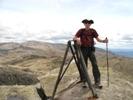
Apparently a section of Roberts Pass is closed due to landslides. I have read that it’s a bit of a joke and there really isn’t any need as the landslides are quite small and passable. I will have to check it out one day as I don’t think it will be fixed in the near future, but for now I was just going up Roberts Pass and back too the golf course. Halfway up the hill there is a small corridor in the cliff and a small steel ladder. I had to take my pack off to squeeze past to climb up it. I had read in one of Jim’s books that he had passed the hat around to purchase and install it, as National Parks had refused. It wasn’t long before I was at the top and I stopped for a bite to eat at Moya Point. That is where I took the picture above of Wentworth Falls and the surrounding cliffs. I had expected to have to walk up the fairway once I had reached the golf course but there is a bit of a nature walk back to the rear of the Fairmont Resort. That is where I found the climbing wall and rope walks. I never knew it was there and I have never heard anything about it before.
All in all it was a great walk and Gladstone Pass really needs a boost in both signage and maintenance. It is a wonderful area and would be so peaceful and cool on a summers afternoon. Who knows with new owners of the resort anything is possible.
Find pictures and map here
Gladstone Pass - Roberts Pass
Forum rules
Posting large/multiple images in this forum is OK. Please start topic titles with the name of the location or track.
For topics focussed on photos rather than the trip, please consider posting in the 'Gallery' forum instead.
This forum is for posting information about trips you have done, not for requesting information about a track or area.
7 posts
• Page 1 of 1
Gladstone Pass - Roberts Pass
![]() by Packo » Sun 21 Aug, 2011 5:50 pm
by Packo » Sun 21 Aug, 2011 5:50 pm
This is me - www.david.patrickson.net
-

Packo - Atherosperma moschatum

- Posts: 51
- Joined: Tue 22 Mar, 2011 9:29 am
- Location: Blue Mountains
- Region: New South Wales
- Gender: Male
Re: Gladstone Pass - Roberts Pass
![]() by climberman » Sun 21 Aug, 2011 5:58 pm
by climberman » Sun 21 Aug, 2011 5:58 pm
What a funny sign. What do you do if you are an experienced navigator walking solo ? Or even with a companion who isn't ? I mean, THEY would be accompanied by an experienced navigator, but you wouldn't. Scary stuff ! It's wild out there ! thank heavans for signs !
- climberman
- Phyllocladus aspleniifolius

- Posts: 656
- Joined: Tue 09 Dec, 2008 7:32 pm
Re: Gladstone Pass - Roberts Pass
![]() by Packo » Sun 21 Aug, 2011 6:28 pm
by Packo » Sun 21 Aug, 2011 6:28 pm
climberman wrote:What a funny sign. What do you do if you are an experienced navigator walking solo ?
LOL Yes I was walking solo and I thought just that. I read the sign. Looked over my left shoulder. Looked over my right shoulder. Faced the sign. Shrugged both my shoulders, and walked straight on past with a smirk.
This is me - www.david.patrickson.net
-
Packo - Atherosperma moschatum
- Posts: 51
- Joined: Tue 22 Mar, 2011 9:29 am
- Location: Blue Mountains
- Region: New South Wales
- Gender: Male
Re: Gladstone Pass - Roberts Pass
![]() by johnw » Mon 22 Aug, 2011 9:10 pm
by johnw » Mon 22 Aug, 2011 9:10 pm
packo wrote:Having just reread Jim Smiths book titled “The Lindeman Pass” I am eager to experience the pass for myself. Just to get a taste I walked down Gladstone Pass, along a small section of Lindeman Pass then up Roberts Pass and back to the car.
Another great report packo. Good to see someone else who enjoys the old historic tracks around the Blueys. When you do the complete Lindeman allow plenty of time. I read Jim Smith's book many years ago. Following that we had several forays in from either end of the pass. The last one we did we had planned to bridge our previous efforts by starting from the western end arriving at a spot below Sublime Point near the Copeland Pass exit then return. However, on the day the track was very muddy and slippery east of Leura Falls. We reached Gordon Falls and decided that continuing east was preferable to going back the same way. So we did the full traverse instead, but I think it took us about 7 hours
I have done the Roberts Pass extension several times. It meets the Vera Falls track and is very muddy in places. It has always had a few dodgy spots requiring a little care and common sense. Nothing outright dangerous that I recall, but I don't know about the current closure reason (there were existing landslips anyway). I'm not sure whether the current steel ladder on upper Roberts Pass is the one that Jim Smith arranged funding for. I have a feeling that it may be a replacement added more recently, although it's been there since the first time I went down the pass.
You will find those funny "experienced navigator" signs at either end of the Lindeman Pass, Roberts Pass and the top end of the Vera Falls track.
John W
In Nature's keeping they are safe, but through the agency of man destruction is making rapid progress - John Muir c1912
In Nature's keeping they are safe, but through the agency of man destruction is making rapid progress - John Muir c1912
-
johnw - Lagarostrobos franklinii

- Posts: 9043
- Joined: Wed 23 Jan, 2008 11:59 am
- Location: Macarthur Region - SW Sydney
- Region: New South Wales
- Gender: Male
Re: Gladstone Pass - Roberts Pass
![]() by FatCanyoner » Sun 18 Sep, 2011 5:43 pm
by FatCanyoner » Sun 18 Sep, 2011 5:43 pm
Gladstone Pass has to be one of the best hidden gems in that part of the mountains. I still remember being blown away going down the stairs beside the canyon-like section. It is not only stunning, but is probably one of the best natural passes into the Jamison as well!
-

FatCanyoner - Athrotaxis selaginoides

- Posts: 1048
- Joined: Fri 12 Aug, 2011 7:45 pm
- Location: Blue Mountains
- ASSOCIATED ORGANISATIONS: www.FatCanyoners.org www.CanyonGear.com.au
- Region: New South Wales
- Gender: Male
Re: Gladstone Pass - Roberts Pass
![]() by jonnosan » Sat 14 Apr, 2012 4:38 pm
by jonnosan » Sat 14 Apr, 2012 4:38 pm
Inspired by this report (and the Jim Smith book) I did the same trip this morning, which I have written up with photos and GPS log at http://www.everytrail.com/view_trip.php?trip_id=1528509
Round trip (including visits to Dash's Cave and Gladstone Mine) was 3.5 hrs.
One item to note is the point where you first drop down into the gorge and cross Gladstone creek is obscured by the foliage of fallen trees. I think it would be quite easy to miss the right spot to descend and end up in a bit of bother. If you are looking, you can see where people of beaten a path through the fallen trees, and the white metal markers are visible, but given the trees are right on (and extend over) the drop into the gully it takes a bit of a leap of faith to climb down into it.
On the upside, there were no leeches today.
I have now (in 3 seperate trips) traversed all the sections of the Lindeman track between Copeland Pass and Vera Falls. I didn't much enjoy the section between Gladstone and Copeland passes (lots of vines, landslides, overgrown sections) so I don't think I will attempt the full traverse in one go but definitely want to do the section I haven't seen yet (Copeland Pass to Leura Falls).
-

jonnosan - Phyllocladus aspleniifolius
- Posts: 896
- Joined: Fri 27 Jan, 2012 4:06 pm
- Region: New South Wales
- Gender: Male
Re: Gladstone Pass - Roberts Pass
![]() by burgo » Mon 23 Apr, 2012 5:01 pm
by burgo » Mon 23 Apr, 2012 5:01 pm
Thanks for your report jonnasan. Advice on the fallen tree was helpful. We (four adults, three children - two 11yrs & one 8 yrs) walked the Roberts Pass/Gladstone Pass circuit on Fri 20 Apr 2012. With the wet season and recent rains the track was very wet and slippery in parts, but even in drier periods I imagine it is always very damp in the passes. We walked down Roberts and up Gladstone Pass following the advice in J & L Daly’s “Take A Walk in the Blue Mountains” (contrary to the advice in Jim Smith’s to go anticlockwise). Up Gladstone is definitely the much easier and safer direction as Gladstone Pass is much more difficult with several scrambles, the dodgy staircase and lots of spots where you are pulling yourself up slippery slopes with tree roots etc. The route is vague in places. Roberts Pass was a little slippery on the steeper bits but much more defined and straightforward. We encountered quite a few leeches along Lindemans Pass but none in the two gorges or up top. Take care navigating soon after crossing Lawtons Creek as there is another track which starts descending. The Lindemans Pass track does a short switchback and climbs up to continue around to the Gladstone Pass gorge. (I assume the lower track is the one to the Gladstone Mine? We didn’t explore this as one of the kids wasn’t enjoying the leeches too much!) At the Lindeman/Gladstone junction you turn upstream briefly then cross back over the creek and ascend the muddy eastern slope with lots on tree roots to hold onto. The track then climbs on the eastern side. It drops to the creek at and we got a little vague here. At one point there are a couple of old steps carved into the right side which don’t seem to go anywhere – perhaps there was a short bridge here originally? We ended up back on the track on the eastern side and climbed up to the base of a rock wall in the eastern cliff line before descending back to the creek. A recently fallen tree obscured the creek crossing here and made the going a bit difficult. Once across we spotted a large mossy covered cairn atop one of the boulders. The track then follows close to the creek to the old stone stairs that ascend the west side of the short slot canyon. This was very wet for us with lots of water cascading from the cliff above. The rope adds a lot of safety here as there is a serious drop near the top of the steps. Care is required. At the top of the falls, where stairs end and you cross the creek back to the east side, there is log across the ledge which makes things difficult. A little further on the eastern side you must leave the main creek by climbing up the right hand corner of the small terraced waterfall coming in from the side gully. There are obvious footholds and roots to help but there was another recent large treefall across the top of the rockface (the one mentioned by jonnosan). Once up the rockface we bashed straight up over fallen branches to regain the track. The track actually contours right and then curves back left to the top of the gully, but is covered by the treefall. The track then climbed out of the rainforest and bar a few other fallen branches and one spot where the track briefly split into three, was straightforward. We reached the intersection with the old track which crosses the head of the valley and went left, back to the cars at Fairmont Place in about 10 minutes. This was clearly the original track before the resort and doesn’t look very much used anymore. All up we took about 4 ½ hours including 30 mins of breaks. That was with three kids in tow but are all fit, able and experienced.
It would great if someone (NPWS?) cleared the two large recent treefalls on the track as they are making the navigation and the going tricky on what is a great walk.
It would great if someone (NPWS?) cleared the two large recent treefalls on the track as they are making the navigation and the going tricky on what is a great walk.
- burgo
- Nothofagus cunninghamii

- Posts: 1
- Joined: Mon 23 Apr, 2012 3:19 pm
- Region: New South Wales
- Gender: Male
7 posts
• Page 1 of 1
Return to NSW & ACT Trip Reports & Track Notes
Who is online
Users browsing this forum: No registered users and 10 guests