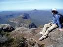
Just back from a fantastic walk on the AAWT out of Canberra. We left after work on Friday and camped at the Orraral Camp Ground arriving about 10. Away at first light on the AAWT from the old tracking station site on the Cotter Hut Rd. Left that to follow the AAWT on a foot track up and over Cotter Gap. Descend beside Pond Ck. before striking across to the Cotter Flats. Wade across the river and up to the hut which is locked. Head up valley on the Yaouk trail before branching off to the Murray Gap Trail. The sign says 4.5k to the NSW border. Almost all of it was steeply up hill. Finally break out into the open on the gap where we stop for lunch. It is overcast and quite cool. Not as steep off the other side. Very pleasant in the upper flats of Dunns Flat Ck. Very pleasant grassy camp site in saddle before the final descent to the Goodradigbee which is crossed at a fancy concrete culvert. ( Even though all the roads are impassable most of the crossings have fancy new concrete culverts? ) Wander up to Oldfields Hut where we take afternoon tea admiring the view out over Bimberi Pk. A few other people in occupation. Then up and over to pick up the Pockets Saddle Rd. which we followed around to Pockets Hut for the night. A very roomy, clean and comfortable hut with excellent camping on the front lawn. One draw back though the dunny lid was nailed shut! A very pleasant evening was spent lounging in front of the fire.
Cold night. Shoes were frozen stiff in the morning. Away at first light. Cut across country and picked up the Leura Gap FT. Followed it down back across the Goodradigbee (another culvert?) then up steeply onto the Rolling Grounds Ridge. Very pleasant once on top. Grassy glens and tall timber. No sign of the ruins to the Leura Gap Hut. The gap itself was very swampy with just enough room for the track on one side. Passed back into ACT and then descended steeply down to the Mt Franklin FT. Here we turned left and followed it down to the Cotter Hut Rd. Here the sign said 24k to the Ginni CP. 20k to the Orraral CP and 10.5k to Yaouk Gap. Quite a remote little intersection. We dropped down to the Cotter River and followed the Cotter Hut Rd up to 80 Acres where we had lunch. Then it was down the other side to Smokers Gap trail whuich we took before leaving it to follow the Orraral Valley trail. We soon lost this in a dry creek bed so cut across country and at length relocated it. Hot going in the open valley with no shade. Passed the old yards and the burnt remains of Rowleys Hut. At length recrossed the AAWT and over the rise was the tracking station site and the car.
An excellent round trip of about 65kms. Thoroughly recommend it.
K.
AAWT Loop.
Forum rules
Posting large/multiple images in this forum is OK. Please start topic titles with the name of the location or track.
For topics focussed on photos rather than the trip, please consider posting in the 'Gallery' forum instead.
This forum is for posting information about trips you have done, not for requesting information about a track or area.
6 posts
• Page 1 of 1
AAWT Loop.
![]() by kanangra » Mon 04 Apr, 2011 7:59 am
by kanangra » Mon 04 Apr, 2011 7:59 am
- kanangra
- Athrotaxis selaginoides

- Posts: 1335
- Joined: Sun 25 May, 2008 3:52 pm
Re: AAWT Loop.
![]() by Tony » Mon 04 Apr, 2011 8:34 am
by Tony » Mon 04 Apr, 2011 8:34 am
Hi Kanagra,
Thanks for the trip report, it is a very nice area to walk, and yes the Murray's gap trail is very steep in places. I did a bit of walking and MT biking in the area many years ago and am trying to fit another trip into the area soon. I have been in the area in January and experienced heavy frosts.
About 17 years ago I rode my bike from Mt Ginini over Laura Gap, around to Murray's Gap and back to Mt Ginini, had a crappy map and got lost twice it took us over 12 hours, the final 24 k from the Cotter Hut to Mt Ginini is all up hill, we struggled on this section and made it back to my car just as darkness fell. I understand that Murray's gap is now closed to bikes, the trip to the top of Bimberi is well worth it as on a nice day it has great views.
What is the Laura gap trail like these days, I have not been there since the 2003 fires.
Tony
There is no such thing as bad weather.....only bad clothing. Norwegian Proverb
-
Tony - Athrotaxis selaginoides
- Posts: 1896
- Joined: Fri 16 May, 2008 1:40 pm
- Location: Canberra
- Region: Australian Capital Territory
Re: AAWT Loop.
![]() by kanangra » Mon 04 Apr, 2011 9:44 am
by kanangra » Mon 04 Apr, 2011 9:44 am
Tony,
Leura Gap FT is now too rough for bikes and is revegetating. Except that is for the fancy culverts. No way you could do that same trip on a bike now. As a walk it is excellent particularly the last few K up to the gap. The Mt Franklin Rd. in from Mt Ginni to Cotter Hut is fine for bikes and so is the Cotter Hut Rd. back out to Orraral Valley. Also you could take the Smokers Gap FT out to the Corin Dam Rd on a bike. The roads on the NSW side in KNP are OK for bikes.
Yes I would have liked to get up Bimberi. Looks a fair lump of a hill from Oldfields. A walk alomg the range to Leura Gap could be interesting with a return via Leura Gap Trail to eaither Pockets or Oldfields.
K.
- kanangra
- Athrotaxis selaginoides
- Posts: 1335
- Joined: Sun 25 May, 2008 3:52 pm
Re: AAWT Loop.
![]() by Tony » Mon 04 Apr, 2011 10:18 am
by Tony » Mon 04 Apr, 2011 10:18 am
kanangra wrote:Tony,
Leura Gap FT is now too rough for bikes and is revegetating. Except that is for the fancy culverts. No way you could do that same trip on a bike now. As a walk it is excellent particularly the last few K up to the gap. The Mt Franklin Rd. in from Mt Ginni to Cotter Hut is fine for bikes and so is the Cotter Hut Rd. back out to Orraral Valley. Also you could take the Smokers Gap FT out to the Corin Dam Rd on a bike. The roads on the NSW side in KNP are OK for bikes.
Yes I would have liked to get up Bimberi. Looks a fair lump of a hill from Oldfields. A walk alomg the range to Leura Gap could be interesting with a return via Leura Gap Trail to eaither Pockets or Oldfields.
K.
Thanks Kanangra, I was just interested if the Laura gap road was still OK, my days of long distant MT biking are probably over, the road is just so much easier on the aging body these days.
Before the fires there was a track from Murrays Gap to the top of Bimberi, but I have been told that the track no longer exists and it is quite a bush bash to the top now, there used to be an old road from the Mt Franklin road between Cotter hut road/ laura gap intersection and the laura gap/Franklin road intersection and went to near the top of Bimberi, many years ago I found the start of it but it was over grown.
I have always wanted to do the boundary walk from Ginini to Gudgenby, but would be tough these days after the fire.
Tony
There is no such thing as bad weather.....only bad clothing. Norwegian Proverb
-
Tony - Athrotaxis selaginoides
- Posts: 1896
- Joined: Fri 16 May, 2008 1:40 pm
- Location: Canberra
- Region: Australian Capital Territory
Re: AAWT Loop.
![]() by kanangra » Mon 04 Apr, 2011 10:29 am
by kanangra » Mon 04 Apr, 2011 10:29 am
Tony,
I know what you mean, age takes its toll on all of us. That must have been a mammoth ride you had all those years ago. I saw no sign of the road you refer to at all.
Another possibility would be to continue from Cotter Hut up and over Yaouk Gap and then down the other side to Lone Pine Trail which you could follow back to Oldfields. This would make a long day trip out of Oldfields Hut.
K.
- kanangra
- Athrotaxis selaginoides
- Posts: 1335
- Joined: Sun 25 May, 2008 3:52 pm
Re: AAWT Loop.
![]() by north-north-west » Tue 05 Apr, 2011 6:44 pm
by north-north-west » Tue 05 Apr, 2011 6:44 pm
kanangra wrote:Another possibility would be to continue from Cotter Hut up and over Yaouk Gap and then down the other side to Lone Pine Trail which you could follow back to Oldfields. This would make a long day trip out of Oldfields Hut.
I've done that loop from Dunns Flat, with a sidetrip up Kelly and down to Oldfields along the ridge. It's a neat little walk.
Tony wrote:Before the fires there was a track from Murrays Gap to the top of Bimberi, but I have been told that the track no longer exists and it is quite a bush bash to the top now...
There are traces of a pad, but nothing consistent. It was a fairly easy walk up though, last time I did it - about two years ago.
"Mit der Dummheit kämpfen Götter selbst vergebens."
-

north-north-west - Lagarostrobos franklinii

- Posts: 15132
- Joined: Thu 14 May, 2009 7:36 pm
- Location: The Asylum
- ASSOCIATED ORGANISATIONS: Social Misfits Anonymous
- Region: Tasmania
6 posts
• Page 1 of 1
Return to NSW & ACT Trip Reports & Track Notes
Who is online
Users browsing this forum: Oldwalker1942 and 16 guests