In reply to Don from a previous topic...
This walk is called the New England Wilderness Walk and there are some photos and a trip report at the following link. I found Don's times to be much the same as ours. http://www.donsmaps.com/bellingerriver.html
My son, who was taking the camera, dipped out at the last minute and in the repack I ended up leaving my camera behind and had to rely on my walk partner for pics and he didn't take many. A watertight case would be a handy thing.
New England National Park and Point Lookout offers many beautiful day walks in cool temperate and subtropical rainforest and this is the only overnighter I've done in that park. There is camping and cabins in the park and if you're in the area then nearby Cathedral Rock National Park (a small but special park) with its granite tors and beautiful waratahs in spring is a must and onward to Armidale are Wollomombi and Apsley Gorges. All within a half hour of each other.
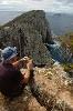
Day 1 - 10km We started out at 11am the first day,dropped off by a friend at the rangers hut on Point Lookout Road at 1300mts. We followed Robinson's Knob trail (a wide tree covered fire trail through beautiful forest (wish I had my camera) in an easy descent through to the Grasstree trail where we had lunch. After our break we went left on the Grasstree trail in a steeper grade and much more overgrown. Though the path was lost sometimes it was just - follow the ridge down. At 4.30 for camp we found a flattish spot, with lots of firewood, on the trail at 700mts a couple of k's past a side 'trail' to an old mine.
Day 2 - 16km The next morning we made the final descent to Sunday Creek at 230mts. There is a nice summer camp spot there, though cold in May and not much fire wood. It's two hours of creek walking from here to the Bellinger River. The river is beautiful here (wish I had my camera) and it would be good to explore the upper reaches next time. At the Bellinger River there is an old road to be found on and off along the river (washed away in the days of early settlement). Multiple river crossings this day but except for one dunking I managed to stay mostly dry. The open sections of land (from previous grazing) along the river were sometimes knee deep in grass (where the road got lost) and sometimes the old road wound through beautiful subtropical rainforest (wish I had my camera).. We made camp at Winch Flat about 5.
Day 3 - 6.5km Woke to a beautiful scene of mist rising from the river (wish I had my camera) and continued through some weedy territory following the path of other walkers through the lantana on the last few kms.
We finished at Dardanelles creek where we had left another car two days before. It's a one and a half hours drive to Point Lookout from there.
The last 15k of this walk along the Bellinger to Brinerville was private land until earlier this year when NPWS bought it although no one has lived in the abandoned buildings for quite some time. I was thrilled to see the New National Park sign when we came to the end at Dardanelles Creek and look forward to seeing the native vegetation regenerate and this beautiful area return to it's natural state, becoming more wilderness like. The water is crystal clear turquoise all along the walk to the last 5k where farmland starts. I'll dig out my other pics of the New England area and post them soon.
New England Wilderness Walk
Forum rules
Posting large/multiple images in this forum is OK. Please start topic titles with the name of the location or track.
For topics focussed on photos rather than the trip, please consider posting in the 'Gallery' forum instead.
This forum is for posting information about trips you have done, not for requesting information about a track or area.
19 posts
• Page 1 of 1
New England Wilderness Walk
![]() by juju » Wed 01 Sep, 2010 12:40 am
by juju » Wed 01 Sep, 2010 12:40 am
- Attachments
-
- Grasstree ridge camp.jpg (303.2 KiB) Viewed 21857 times
-
- Sunday Creek.jpg (293.79 KiB) Viewed 21857 times
-
- Where's the road.jpg (268.16 KiB) Viewed 21857 times
-
- Upper Bellinger crossing.jpg (219.33 KiB) Viewed 21857 times
-
- Upper Bellinger ruin.jpg (347.52 KiB) Viewed 21857 times
We'll get fit on the way.
-
juju - Athrotaxis cupressoides

- Posts: 415
- Joined: Mon 09 Nov, 2009 12:47 pm
- Location: Bellingen
- Region: New South Wales
- Gender: Female
Re: New England Wilderness Walk
![]() by Rod » Wed 01 Sep, 2010 11:31 am
by Rod » Wed 01 Sep, 2010 11:31 am
Hi Julie
Thanks very much for taking the time to post the report.
Looks like it was a great walk-Sunday creek looks beautiful !
Great to see some action from the mainlanders!
I do quite a lot of flyfishing in the New England area-stunning scenery in our backyard..
Look forward to seeing any more photos/reports etc from our area
All the best
Rod
- Rod
- Nothofagus gunnii

- Posts: 24
- Joined: Mon 12 Mar, 2007 9:35 am
- Location: Lennox Head
Re: New England Wilderness Walk
![]() by juju » Wed 01 Sep, 2010 8:04 pm
by juju » Wed 01 Sep, 2010 8:04 pm
That's okay, good to give some info for a change - I'm always taking it! Julie
We'll get fit on the way.
-
juju - Athrotaxis cupressoides
- Posts: 415
- Joined: Mon 09 Nov, 2009 12:47 pm
- Location: Bellingen
- Region: New South Wales
- Gender: Female
Re: New England Wilderness Walk
![]() by iandsmith » Tue 07 Sep, 2010 7:50 pm
by iandsmith » Tue 07 Sep, 2010 7:50 pm
Mmmm, it is a shame you didn't have a decent camera!
I was up at Nymboida, Ebor and Uralla last week.
I was up at Nymboida, Ebor and Uralla last week.
-
iandsmith - Athrotaxis cupressoides
- Posts: 366
- Joined: Thu 22 Jan, 2009 3:27 pm
- Location: Newcastle
Re: New England Wilderness Walk
![]() by juju » Tue 07 Sep, 2010 9:03 pm
by juju » Tue 07 Sep, 2010 9:03 pm
Yes - I really will have to do it again and take my own camera. I had knee trouble (a recurring problem on long downhills with no ups) that I thought was gone and pretty much hobbled on any downhill bits from the second day, but have been having physio and hope the stretching I'm doing is fixing the problem. What did you do up in the New England area?
We'll get fit on the way.
-
juju - Athrotaxis cupressoides
- Posts: 415
- Joined: Mon 09 Nov, 2009 12:47 pm
- Location: Bellingen
- Region: New South Wales
- Gender: Female
Re: New England Wilderness Walk
![]() by WarrenH » Sun 12 Sep, 2010 4:07 am
by WarrenH » Sun 12 Sep, 2010 4:07 am
" ... my walk partner for pics and he didn't take many."
If the bloke had have taken more images, I would have bought the book. That's no joke. They are great shots.
The first shot is one of the best camp site images that I've seen. The shot looks totally heroic for the possibility of snakes travelling through. I'm also very impressed at the apparent fullness of that red 'Liqueur Land' bag (?).
The camp site image is first class. Roadside camping?
Warren.
- WarrenH
- Phyllocladus aspleniifolius

- Posts: 991
- Joined: Thu 07 Jan, 2010 6:54 pm
- Region: Australian Capital Territory
Re: New England Wilderness Walk
![]() by juju » Sun 12 Sep, 2010 11:53 am
by juju » Sun 12 Sep, 2010 11:53 am
Warren, I feel quite embarrassed - your photos are art - I have to catch my breath when I see them! esp Walking in the Budawangs, A few Winter walks, etc etc etc
- That camp was on a clear spot (it's mostly overgrown) of the unmaintained Grasstree trail.
- My friend used to do a lot of overnight and off track stuff in Uni (before kids) and doesn't have any gear, so threw together what he could find for this walk.
- Didn't know it was a Liquerland bag...are you bein' funny?
- There would be a lot of brown snakes in the warm weather. We saw a sleepy red bellied black in May.
The acquisition of the upper Bellinger land is a great addition to the New England National Park as it protects a good deal of the Bellinger River. It will be exciting to see it return to 'Wilderness'.
How's your BNT plans going?
Julie
We'll get fit on the way.
-
juju - Athrotaxis cupressoides
- Posts: 415
- Joined: Mon 09 Nov, 2009 12:47 pm
- Location: Bellingen
- Region: New South Wales
- Gender: Female
Re: New England Wilderness Walk
![]() by iandsmith » Wed 27 Oct, 2010 4:42 pm
by iandsmith » Wed 27 Oct, 2010 4:42 pm
Sorry for not getting back sooner; slackness on my part.
I was up visiting my nephew who has just moved to acreage near Nymboida (lucky me, free accommodation). He took me to where the Little Nymboida and the Nymboida meet. About three weeks after my visit he and his partner kayaked down a part of the river. On his property he has also constructed a mountain bike trail, another of his passions.
I also went to a park at Hortons Creek where I spent time shooting birds (great spot if anyone's interested). Later I moved on and spent the night at Ebor Falls before heading on to some friends I know further south.
I'll include a few pics, hope you enjoy.
Cheers, Ian
- Attachments
-
- Taken at Hortons Creek where there are some remnants of civilization
-
- Where the two rivers meet
- Nymboida 207.jpg (110.45 KiB) Viewed 21534 times
-
- Taken at Cloud Creek
-
- Taken at my nephew's place
-
- Eucalypt beside Horton's Creek
- Hortons Creek (10).jpg (109.66 KiB) Viewed 21534 times
-
iandsmith - Athrotaxis cupressoides
- Posts: 366
- Joined: Thu 22 Jan, 2009 3:27 pm
- Location: Newcastle
Re: New England Wilderness Walk
![]() by north-north-west » Thu 28 Oct, 2010 7:00 pm
by north-north-west » Thu 28 Oct, 2010 7:00 pm
Blue Faced Honeyeaters in the backyard. That's just brilliant.
I am so jealous.
I am so jealous.
"Mit der Dummheit kämpfen Götter selbst vergebens."
-

north-north-west - Lagarostrobos franklinii

- Posts: 15145
- Joined: Thu 14 May, 2009 7:36 pm
- Location: The Asylum
- ASSOCIATED ORGANISATIONS: Social Misfits Anonymous
- Region: Tasmania
Re: New England Wilderness Walk
![]() by iandsmith » Thu 28 Oct, 2010 8:02 pm
by iandsmith » Thu 28 Oct, 2010 8:02 pm
In the same area there are regent honeyeaters, varied trillers, azure kingfishers, white faced honeyeaters, satin bowerbirds and so many others I've forgotten. I'm trying to get back there in November.
-
iandsmith - Athrotaxis cupressoides
- Posts: 366
- Joined: Thu 22 Jan, 2009 3:27 pm
- Location: Newcastle
Re: New England Wilderness Walk
![]() by juju » Fri 29 Oct, 2010 7:34 am
by juju » Fri 29 Oct, 2010 7:34 am
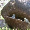
Beautiful photos Ian. What's your camera?
Here's a not so good one of a spotted pardalote outside my kitchen window, my confounded digital thought I'd like a pic of the grevillea it was sitting in...When I was a teenager my brother gave me his Mamiya - fully manual, could shoot a pardalote from the kitchen window blind folded.
Here's a not so good one of a spotted pardalote outside my kitchen window, my confounded digital thought I'd like a pic of the grevillea it was sitting in...When I was a teenager my brother gave me his Mamiya - fully manual, could shoot a pardalote from the kitchen window blind folded.
- Attachments
-
- Spotted Pardalote .jpg (162.16 KiB) Viewed 21501 times
We'll get fit on the way.
-
juju - Athrotaxis cupressoides
- Posts: 415
- Joined: Mon 09 Nov, 2009 12:47 pm
- Location: Bellingen
- Region: New South Wales
- Gender: Female
Re: New England Wilderness Walk
![]() by Girlie » Sun 16 Jan, 2011 10:59 am
by Girlie » Sun 16 Jan, 2011 10:59 am
Really enjoyed this report and the accompanying photos. Would love to have some of those wonderful birds in my backyard!
- Girlie
- Nothofagus cunninghamii

- Posts: 3
- Joined: Sun 16 Jan, 2011 10:16 am
- Region: New South Wales
- Gender: Female
Re: New England Wilderness Walk
![]() by iandsmith » Tue 08 Feb, 2011 8:17 pm
by iandsmith » Tue 08 Feb, 2011 8:17 pm
Not sure if I answered this or not. I have two nikon SLRs and I now shoot birds with a 50-500mm Sigma lens as advised by one of the great (in my opinion) bird photographers, Alwyn Simple.
Gosh, I would kill to get that close to a pardalote though. I managed a couple of reasonable ones in Victoria and at Uralla.
Currently heading to Tassie.
Cheers, Ian
Gosh, I would kill to get that close to a pardalote though. I managed a couple of reasonable ones in Victoria and at Uralla.
Currently heading to Tassie.
Cheers, Ian
-
iandsmith - Athrotaxis cupressoides
- Posts: 366
- Joined: Thu 22 Jan, 2009 3:27 pm
- Location: Newcastle
Re: New England Wilderness Walk
![]() by juju » Wed 09 Feb, 2011 9:43 am
by juju » Wed 09 Feb, 2011 9:43 am
iandsmith wrote:Not sure if I answered this or not. I have two nikon SLRs and I now shoot birds with a 50-500mm Sigma lens as advised by one of the great (in my opinion) bird photographers, Alwyn Simple.
Gosh, I would kill to get that close to a pardalote though. I managed a couple of reasonable ones in Victoria and at Uralla.
Currently heading to Tassie.
Cheers, Ian
Gees you get around!
I told my mum, who lived in Sydney, about the Pardalote and she said she used to see them often years ago.
We'll get fit on the way.
-
juju - Athrotaxis cupressoides
- Posts: 415
- Joined: Mon 09 Nov, 2009 12:47 pm
- Location: Bellingen
- Region: New South Wales
- Gender: Female
Re: New England Wilderness Walk
![]() by iandsmith » Fri 04 Mar, 2011 10:50 pm
by iandsmith » Fri 04 Mar, 2011 10:50 pm
So, there I was in the New England shooting thornbirds.....oooops, pardalotes!
- Attachments
-
- Striated pardalote
-
-
iandsmith - Athrotaxis cupressoides
- Posts: 366
- Joined: Thu 22 Jan, 2009 3:27 pm
- Location: Newcastle
Re: New England Wilderness Walk
![]() by juju » Thu 10 Mar, 2011 10:31 am
by juju » Thu 10 Mar, 2011 10:31 am
You've seen a lot a pardies! 
We'll get fit on the way.
-
juju - Athrotaxis cupressoides
- Posts: 415
- Joined: Mon 09 Nov, 2009 12:47 pm
- Location: Bellingen
- Region: New South Wales
- Gender: Female
Re: New England Wilderness Walk
![]() by iandsmith » Tue 15 Mar, 2011 9:41 pm
by iandsmith » Tue 15 Mar, 2011 9:41 pm
Just making plans to head your way very late April/early May.
You up for a walk still?
Cheers, Ian
You up for a walk still?
Cheers, Ian
-
iandsmith - Athrotaxis cupressoides
- Posts: 366
- Joined: Thu 22 Jan, 2009 3:27 pm
- Location: Newcastle
Re: New England Wilderness Walk
![]() by juju » Wed 16 Mar, 2011 5:16 pm
by juju » Wed 16 Mar, 2011 5:16 pm
yep, that would be fun. I'm back from a two week holiday in Tassie on 10th April. Julie
We'll get fit on the way.
-
juju - Athrotaxis cupressoides
- Posts: 415
- Joined: Mon 09 Nov, 2009 12:47 pm
- Location: Bellingen
- Region: New South Wales
- Gender: Female
Re: New England Wilderness Walk
![]() by iandsmith » Thu 31 Mar, 2011 10:20 pm
by iandsmith » Thu 31 Mar, 2011 10:20 pm
Right, I have a rough schedule worked out of my life for the next couple of months.
Next four weeks are taken up with an exhibition I have in Newcastle then, at the end of the month, I plan to head your way.
I usually go up the coast and down the New England so I would normally expect to be around your area around, say, Wednesday-ish.
Is midweek okay or do you have to work (what a terrible four letter word that is!).
I also usually stay at my nephews at Nymboida if you want to head out from there. A little unsure of my territory in your world.
My email address is [email protected]
Cheers, Ian
-
iandsmith - Athrotaxis cupressoides
- Posts: 366
- Joined: Thu 22 Jan, 2009 3:27 pm
- Location: Newcastle
19 posts
• Page 1 of 1
Return to NSW & ACT Trip Reports & Track Notes
Who is online
Users browsing this forum: Facebook [bot] and 15 guests