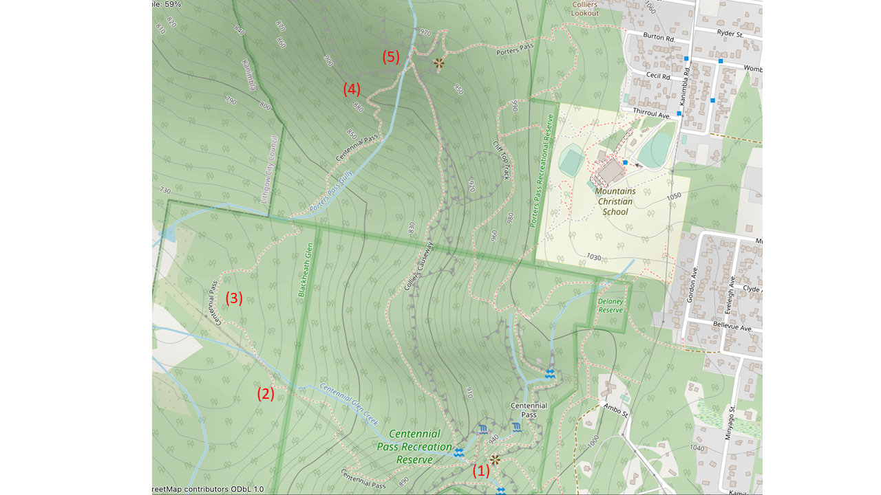
The historical part of Centennial Pass was apparently built to an excellent standard a very long time ago, presumably around the time of Australian centennial in 1888. The remains of a wide benched track are apparent in places, as are some well-constructed stone steps. There is evidence of some tree-clearing many decades ago, and since then the track has received no apparent maintenance aside from placement of a small number of tapes. The route is now very difficult to follow in places due to overgrowth and treefalls, and good navigation skill is required. It is accurately shown on Open Street Map (OSM), and a GPS device with OSM loaded is recommended. (We used the Topo GPS app on a phone.)

Our walk started at the end of Burton Rd, Blackheath (29/5/22). A fire trail then a foot track leads to the end of Thirroul Ave, where a clearly-marked new track runs near the western boundary of the Mountains Christian School to Fort Rock.
The maintained parts of Centennial Pass and Porters Pass are described elsewhere, e.g.http://www.wildwalks.com/bushwalking-and-hiking-in-nsw/blue-mountains-blackheath-/walls-ledge-porters-pass-centennial-glen-circuit.html
The historical track starts at the bottom of the lowest handrail on the maintained Centennial Pass track (1), shortly before the maintained track crosses Centennial Glen Creek and becomes Colliers Causeway. It’s a fairly obvious turnoff if you’re looking for it with aid of OSM. Duck left under the rail, and follow a fairly distinct track to the WSW which soon descends. The trail becomes indistinct on a wide dry ridge - watch out for a few stone cairns on the north side of the ridge. The trail soon swings north then descends again. A GPS is useful at several points to work out where the route is heading. The trail then essentially disappears in a marsh covered in bracken (2). At this point, bash your way over to the creek and follow it down, where the trail becomes apparent again, and crosses the creek at a point marked with a couple of tapes. The trail then runs down the north side of the creek for a couple of hundred metres, and is relatively easy to navigate despite being overgrown with bracken, and despite a couple of tricky tree-falls. It then climbs slightly and swings north near an old fence line through nice open eucalypt wood which is a good winter lunch spot (3).
The trail proceeds NE to Porters Pass Gully, where it descends to the creek through more bracken. The trail becomes more obvious at the creek, where it crosses the creek and heads slightly downstream before climbing a relatively dry wooded ridge on the north side. The trail is initially indistinct on the ridge top before becoming more distinct as the ridge narrows. A large tree fall is passed under the trunk, before the old track, now fairly distinct, climbs back towards the creek.
The final part of the historical track is the highlight of the walk. A series of mossy stone stairs have a wonderful “forgotten world” feel (4). They climb steeply for a couple of hundred metres before the track crosses the creek again, and soon rejoins the maintained track at the junction of Collier’s Causeway and Porter’s pass (5).
Total time for the loop from Burton St: about 4.5 hours plus breaks.


