The second time the roads were closed so I did Adamson’s falls instead which was very overgrown with lots of lyrebirds and a great view at the end. The third time I arrived on the plateau late in the afternoon expecting to spend a night at the hut. Or alternately I borrowed a one man tent from my brother in law. As it turns out the hut is no hut at all and the one man tent if you can really call it that was a beach tent. That would be fine if the weather was fine, but considering I had managed to arrive in another snow storm the beach tent was all but useless!
So. I picked the weather for my fourth attempt and headed down early morning arriving at 6:00am. I set off with my head lamp on and after reading the log book realised that I would be the first person up there in the last 5 days. That means 5 days of spider webs to clear! Thankfully after pushing through hundreds of webs I only ever had 2 spiders on me...that I could see
The track, which I had done twice before could be a little boring for the first climb but thankfully I have a slight fascination with the various forms of fungus on the way up. There are also some huge tree stumps with markings in them from when the trees used to be manually felled and hauled down on rails behind horses.
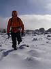
The sun slowly rose and the birds began to sound. My only thought then was that I wish I were at the plateau already to see the early morning sun on the peak. I hurried my way up and entered the alpine vegetation elevation which looked much different from the last time I was there. I hadn't seen it without snow before. Not quite as picturesque but much easier walking. The track can be wet and slippery at times on the way up this first climb and snow covering the track doesn't necessarily help.
Not long after that and I emerged at the plateau with great views looking back out to Tasman Island and up to Mt Wellington. The day turned out to be a cracker. After arriving at the plateau the track splits to go in two directions. Well sort of...I turned left and headed to the hut to have a look at it. It's not really much of a hut with one semicircular wall, no roof, and no floor. But the wall is quite impressive none the less and the views from here looking east are great.
I noticed that there were a few cairns heading West and South from the hut. I assumed that the Westerly cairn led to the peak but decided to back track to where the track splits according to the map. I noticed that there were a few rocks put across the track leading to the peak and wondered if this track was no longer used. However, to minimise damage to the alpine plateau I headed across the stones and toward the peak. The track soon disappears and it turns into a choose your own adventure track. With the peak in plain view I headed straight for it.
The plateau was spectacular with numerous reflective pools and cushion plants along the way. I imagine in spring this would be alive with wildflowers. It's a nice easily walk after slogging up the first climb. The view widens at this point to include Mt La Perouse and Hartz Peak and Mt Snowy.
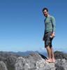
I then headed up the final climb to the summit. This part of the walk ranges from mud and thick foliage to wide open rocky areas and finally a boulder field at the very end. The mud wasn't very deep at the time but I imagine after a fair bit of rain that could all change. I couldn't believe I was finally approaching the summit after all those failed attempts. And to think it could be this easy given some fine weather. After 3 and 1/2 hours I arrived at the top. I set the camera up with the 10 second timer on and ran to the final rock stack only just getting there in time for the shot.
I had finally arrived at 9:30am and the views were amazing. I spent some time looking at all the peaks in the distance. They included Mt La Perouse, Pindars Peak, Precipitous Bluff, The Ironbound Ranges, Federation Peak, Mt Anne, Mt Lot, and Lot's Wife, Hartz Peak and My Snowy, Collins Bonnet, Trestle Mountain and Mt Wellington, Tasman Island and right around to Cockle Creek. Amazing!
I walked around for a while at the top which was mainly scree and boulders and then began the decent. The various tracks on the plateau, if you call them tracks seemed to head back to the hut. I assume that this means that the track on the map I had was a little outdated and the walk to the top now goes via the hut. I then headed down the final decent to the Subaru waiting at the bottom.
Overall this is a highly recommended walk. The initial climb is just a bit of hard work but arriving at the plateau that is all forgotten and the vista overrides the last two hours of uphill hiking. The only real negative I had from the day was that I had put too much powerade powder in my bladder so that after a while I got a sugar headache. So it was either drink the sugar water or become dehydrated.
The walk ends there after a total of 7 1/2 hours, but the drive back to Hobart is littered with great views including the photo of the Huon River below taken at Franklin. I hope more people do this walk and enjoy the views and clear the webs for those of us proceeding after them.
Here is a link to my flickr photos:
This trip - http://www.flickr.com/photos/taspicsvns/sets/72157626465635067/
Previous trip - http://www.flickr.com/photos/taspicsvns/sets/72157600887098744/
A sample of the photo's are below.
- Looking East from the plateau
- Reflective pool on the Plateau
- The peak boulder field