Mt Lord/Lanes Peak

Trip reports, stories, track notes. Multiple/large photos are OK in this forum.
Forum rules
Posting large/multiple images in this forum is OK. Please start topic titles with the name of the location or track.

For topics focussed on photos rather than the trip, please consider posting in the 'Gallery' forum instead.

This forum is for posting information about trips you have done, not for requesting information about a track or area.

Mt Lord/Lanes Peak

Postby stepbystep » Sat 24 Jul, 2010 6:56 am

Hi all,
after much deliberation over the weather I left home yesterday at 5am POSITIVE of a bluesky day in the SW, had been itching for a descent walk and this was to be the day.
I had intentions of traversing The Sentinel Range if the weather was good but entering Maydena the lack of stars in the sky caused me to go to a backup plan and hung a right onto the now all too familiar Florentine Road.
The adjusted plan was to take in a circuit walk over Lanes Peak, across to Mt Lord and back to the car via the forest. I got my car to within 900-odd metres of the Lanes Peak summit but with 600 metres vertically to gain. The walk starts in a logging coupe - lovely - after negotiating this I plunged into the forest immediately being hit by a wall of dense Baura regrowth, fortunately the forest soon opened up and despite thick bands of scrub progress was pretty good, not so good 15 mins later when I stumbled on another forestry road, doh. Now at the spot most would start the walk I re-entered the forest and found the going pretty smooth.
The forest was saturated and pretty soon I was to, with my nearly 4 year old Gore-tex jacket close to useless. The forest up to Lanes is a mixture of Sassafrass, Myrtyle, Pandani and the usual central SW scrub with plenty of rocky outcrops to make route finding interesting(in a good way).
The summit turned out to be anticlimactic as the fog in the valley extended all the way to the mountain top.......I didn't linger.
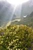
Spotting a tarn just below Mt Lord on the GPS I headed straight for it. Dropping to the plateau between the 2 peaks I could see this as being very pleasant walking and a very attractive area in the right conditions, with lots of low growing Scoparia that would put on a nice display when flowering but then I could only ever see 20-odd metres ahead, I came across several pads both animal and human but couldn't find one that lasted. The tarn was the highlight of the day, feeling 'atmospheric' to say the least. From here I could see the outline of Mt Lord and a blueish tinge above the summit, so I headed up hopeful of a good view. I have long wanted to take in the view back to K-Col and the rest of the Mt Field park as I had often gazed towards Lord from K-Col.
This was a really enjoyable climb through snow gum forest and in and around many rocky outcrops and small clifflines - good fun. The views however were not to be and SW Tas once again foiled my plans. Hanging around for half an hour all I got to see was the shape of Field West with mist pouring off it and a strange corona lighting effect, a bit like a giant bright white rainbow, really strange, but cool.
Speaking of cool I was damn near frozen and gave up on my views, deciding a return trip to Mt Lord will be on the cards in good weather, probably via Newdegate Pass and Tarn Shelf.
The descent back to the road was great fun through really attractive forest and having warmed up I took my time coming down.
With a change of clothes and a feed I headed home, not before taking a sidetrip up Tim Shea in the vain hope for some good views, not to be unfortunately, the obligatory coffee at The Possum Shed and I was home in Hobart by 3pm - of course it was great weather all day in Hobart - should have just gone up Wello :roll:

All-in-all a successful peakbagging mission but not the bluebird day I was so keen for, maybe I will try again next week.........
Attachments
Unnamed tarn.jpg
Unnamed tarn below Mt Lord
Pandani.jpg
Pandani
Mt Lord Summit.jpg
Mt Lord Summit and blue sky so close.........
The idea of wilderness needs no defense, it only needs defenders ~ Edward Abbey
User avatar
stepbystep
Lagarostrobos franklinii
 
Posts: 7707
Joined: Tue 19 May, 2009 10:19 am
Location: Street urchin
Region: Tasmania
Gender: Male

Re: Mt Lord/Lanes Peak

Postby bluewombat » Sat 24 Jul, 2010 8:54 am

Nice description SBS, nice photos too. Lord has been on my to do list for ages, but somehow never seem to get there. What is the general gist of the roads out to Lane.
bw
Even a long life is short
HPB
User avatar
bluewombat
Athrotaxis cupressoides
 
Posts: 327
Joined: Sun 10 Feb, 2008 3:55 pm
Region: Tasmania

Re: Mt Lord/Lanes Peak

Postby stepbystep » Sat 24 Jul, 2010 4:44 pm

Cheers bw, sure you weren't up there, it was cold and I'm sure I saw a blue wombat or two about :wink:
As described I parked at the wrong spot(helps to have a navigator) and walked probably an extra kilometer. Pretty easy to find.
The graphic should explain all, basically Florentine to Westfield and then up into the coupes.....
Attachments
ROUTES AND ROADS copy.jpg
The idea of wilderness needs no defense, it only needs defenders ~ Edward Abbey
User avatar
stepbystep
Lagarostrobos franklinii
 
Posts: 7707
Joined: Tue 19 May, 2009 10:19 am
Location: Street urchin
Region: Tasmania
Gender: Male

Re: Mt Lord/Lanes Peak

Postby bluewombat » Sun 25 Jul, 2010 3:06 pm

Thanks SBS
and yes that is what inspired my nom de plume, wombats pushing through the snow.
bw
Even a long life is short
HPB
User avatar
bluewombat
Athrotaxis cupressoides
 
Posts: 327
Joined: Sun 10 Feb, 2008 3:55 pm
Region: Tasmania

Re: Mt Lord/Lanes Peak

Postby ILUVSWTAS » Sun 25 Jul, 2010 8:04 pm

Thats my Sw for ya Dan, It can be a gorgeous day even at our place, but the line from Hartz and beyond is more often than not GREY.
I've only seen Picton from Vinces Saddle once in the last month or so.

Good work on the walk tho!! You should have studied the map i showed ya harder and you'd have seen the higher road :lol:
Nothing to see here.
User avatar
ILUVSWTAS
Lagarostrobos franklinii
 
Posts: 11046
Joined: Sun 28 Dec, 2008 9:53 am
Region: Tasmania
Gender: Male

Re: Mt Lord/Lanes Peak

Postby stepbystep » Sun 25 Jul, 2010 8:35 pm

ILUVSWTAS wrote:You should have studied the map i showed ya harder and you'd have seen the higher road :lol:


Never have been good at studying :roll: 200 metres is quite a bit when it's thick wet scrub....

333 mate, half the number of the beast :twisted: :twisted: :twisted: NE done???
The idea of wilderness needs no defense, it only needs defenders ~ Edward Abbey
User avatar
stepbystep
Lagarostrobos franklinii
 
Posts: 7707
Joined: Tue 19 May, 2009 10:19 am
Location: Street urchin
Region: Tasmania
Gender: Male

Re: Mt Lord/Lanes Peak

Postby ILUVSWTAS » Sun 25 Jul, 2010 8:53 pm

Haha, So THATS why I was so excited about reaching 333.

Yup NE zone done!! Besides the friggin Islands which should be a zone of their own.

Cameron is a fantastic walk. Very similar to the Hazards.
Nothing to see here.
User avatar
ILUVSWTAS
Lagarostrobos franklinii
 
Posts: 11046
Joined: Sun 28 Dec, 2008 9:53 am
Region: Tasmania
Gender: Male

Re: Mt Lord/Lanes Peak

Postby frenchy_84 » Tue 27 Jul, 2010 3:56 pm

were keys required for those forestry roads?
User avatar
frenchy_84
Athrotaxis selaginoides
 
Posts: 1529
Joined: Tue 04 Nov, 2008 7:00 pm
Region: Queensland
Gender: Male

Re: Mt Lord/Lanes Peak

Postby stepbystep » Tue 27 Jul, 2010 4:04 pm

frenchy_84 wrote:were keys required for those forestry roads?


Nope, usually all open, might be worth calling the day before. I didn't bother.
The idea of wilderness needs no defense, it only needs defenders ~ Edward Abbey
User avatar
stepbystep
Lagarostrobos franklinii
 
Posts: 7707
Joined: Tue 19 May, 2009 10:19 am
Location: Street urchin
Region: Tasmania
Gender: Male

Re: Mt Lord/Lanes Peak

Postby Bap » Sun 01 Aug, 2010 10:07 am

stepbystep wrote: the shape of Field West with mist pouring off it and a strange corona lighting effect,


Was this a Broken Spectre?
It is easier to go down a hill than up, but the view is much better at the top.
User avatar
Bap
Phyllocladus aspleniifolius
 
Posts: 566
Joined: Thu 25 Mar, 2010 8:26 pm
Location: Hobart
Region: Tasmania
Gender: Male

Re: Mt Lord/Lanes Peak

Postby stepbystep » Sun 01 Aug, 2010 10:33 am

More like a fogbow, this kinda thing but huuuuuge.....
Attachments
Fogbow,_spectre_and_glory.jpg
The idea of wilderness needs no defense, it only needs defenders ~ Edward Abbey
User avatar
stepbystep
Lagarostrobos franklinii
 
Posts: 7707
Joined: Tue 19 May, 2009 10:19 am
Location: Street urchin
Region: Tasmania
Gender: Male

Re: Mt Lord/Lanes Peak

Postby Bap » Sun 01 Aug, 2010 11:58 am

Looks really interesting, where was this shot taken and what is the red in the corner??
It is easier to go down a hill than up, but the view is much better at the top.
User avatar
Bap
Phyllocladus aspleniifolius
 
Posts: 566
Joined: Thu 25 Mar, 2010 8:26 pm
Location: Hobart
Region: Tasmania
Gender: Male

Re: Mt Lord/Lanes Peak

Postby stepbystep » Sun 01 Aug, 2010 12:23 pm

The idea of wilderness needs no defense, it only needs defenders ~ Edward Abbey
User avatar
stepbystep
Lagarostrobos franklinii
 
Posts: 7707
Joined: Tue 19 May, 2009 10:19 am
Location: Street urchin
Region: Tasmania
Gender: Male

Re: Mt Lord/Lanes Peak

Postby bluewombat » Wed 26 Jan, 2011 5:26 pm

Just a quick heads up on access to Lane's Peak. I was up there today and there is a fair sized tree across the road about 2kms from the start of the walk up to Lane's, just past the end of the coupe where SBS shows his return path from Mt Lord intersecting with the access road. This just means a bit of additional walking. Took me about 3hrs 30min from that point to top of Lane's and back. I like this peak, nice forest, interesting cliffs and sensational views. It has the usual exuberant excess of slippery rocks and rotten trees but it is pretty straight forwards, basically up. I started at the edge of the coupe just past SBS's 'correct start/finish position and basically headed due east to the top. To avoid the worst of the cliffs on the way down I went a little further NW and came down some scree before hooking around to the west. Will post a photo if I have any that look interesting.
Even a long life is short
HPB
User avatar
bluewombat
Athrotaxis cupressoides
 
Posts: 327
Joined: Sun 10 Feb, 2008 3:55 pm
Region: Tasmania

Mt Lord from the west side

Postby bluewombat » Wed 27 Apr, 2011 7:44 pm

I have been to Lake Emmett several times but for a variety of reasons (excuses) I have never actually been up Mt Lord. Inspired by the relatively short distance from the forestry roads to the west of Lord and SBS's route map I decided to wander up that way on Anzac day. The initial outlook was a little grim, thick cloud at Florentine gap and then more of the same along Westfield road. I pressed on and about 100m before the car parking place I broke through the cloud and was presented with a glorious day, and some very atmospheric views

P1050056_Small.JPG
P1050056_Small.JPG (82.47 KiB) Viewed 21679 times


P1050057_Small.JPG
P1050057_Small.JPG (60.18 KiB) Viewed 21679 times


P1050059_Small.JPG
P1050059_Small.JPG (29.5 KiB) Viewed 21679 times


I could see the cliff lines on Lord and decided to try and stick to the north of the actual summit until I got to the final ridge. The first hour or so was pleasant walking in steep but relatively open rainforest. The final third of the climb was tougher as I had drifted south a little and had to fight my way through some nasty scrub (typical of the western side of this range in my experience) and a few broken cliff lines, finding myself up a crack with my pack wedged in a tree at one stage.
Eventually I worked my way up to the summit and was greeted with super views back to K-Col and Field West and out to Wedge and further north to Wylds Crag.

P1050062_Small.JPG
Looking south to K-Col and Field West
P1050062_Small.JPG (75.77 KiB) Viewed 21679 times


The trip down was a little smoother, I headed north an extra 50 metres and avoided all the cliff lines although the going was a little damper. Eventually (virtually back at the road) you are travelling next to a sizable stream.
Round trip was about 3 hrs 30 mins. A couple of cautions about this walk, 1. there is no standing water anywhere on top, 2. it should not be treated as an easy way up Lord, it is shorter but off track and not marked in any way, (the classic approach via Lake Emmett is at least vaguely marked and certainly more scenic). All in all a pleasant trog. 3/5
bw
Even a long life is short
HPB
User avatar
bluewombat
Athrotaxis cupressoides
 
Posts: 327
Joined: Sun 10 Feb, 2008 3:55 pm
Region: Tasmania

Re: Mt Lord/Lanes Peak

Postby stepbystep » Wed 27 Apr, 2011 9:53 pm

Nice one bw, seems you found a new and interesting way like we all often do, there is a lovely rock stream between Lanes and Lord that provides very easy access, and in my case exit. At least you got some views, very atmospheric despite the plantation.
The idea of wilderness needs no defense, it only needs defenders ~ Edward Abbey
User avatar
stepbystep
Lagarostrobos franklinii
 
Posts: 7707
Joined: Tue 19 May, 2009 10:19 am
Location: Street urchin
Region: Tasmania
Gender: Male

Re: Mt Lord/Lanes Peak

Postby bluewombat » Wed 27 Apr, 2011 10:17 pm

At least the plantations were covered up by the fog for a while sbs, but there was one nasty smouldering mess to drive past on Westfield at one stage. As for the 'interesting way up' I am afraid cliffs just have a magnetic effect on me, too many years of climbing, I just cant resist a little scramble. You are right about the rocky stream I followed it most of the way down.
bw
Even a long life is short
HPB
User avatar
bluewombat
Athrotaxis cupressoides
 
Posts: 327
Joined: Sun 10 Feb, 2008 3:55 pm
Region: Tasmania

Re: Mt Lord/Lanes Peak

Postby Doonish » Sun 31 Mar, 2013 9:15 am

Sorry to bump an old thread with a marginally altered context, but I was just wondering what the track to Mount Lord is like from the Lake Emmett side? Abels 1 suggests there is a route heading off about 1/2 km up from Lake Newdegate, but I have heard that it's not a lot of fun these days. Any information would be most appreciated. Is it relatively easy to find and follow?
Doonish
Atherosperma moschatum
 
Posts: 54
Joined: Sat 15 Sep, 2012 12:19 pm
ASSOCIATED ORGANISATIONS: Fullers Bookshop
Region: Tasmania
Gender: Male

Re: Mt Lord/Lanes Peak

Postby mjdalessa » Sun 31 Mar, 2013 10:04 am

There is still a cairn line up to the summit from that side and bits of pad, but many cairns seem to have been knocked over. There seemed to be a vague but followable pad in the alpine stuff a bit lower down- I wouldn't rely on it though. No idea about the rest of it.
Recent Peaks: Snowy South, Ben Nevis, Victoria, Blackboy, Bastion
mjdalessa
Phyllocladus aspleniifolius
 
Posts: 590
Joined: Fri 06 Feb, 2009 10:28 am
Region: Tasmania

Re: Mt Lord/Lanes Peak

Postby Doonish » Thu 04 Apr, 2013 7:10 pm

Thanks mjdalessa, appreciate the info.
Doonish
Atherosperma moschatum
 
Posts: 54
Joined: Sat 15 Sep, 2012 12:19 pm
ASSOCIATED ORGANISATIONS: Fullers Bookshop
Region: Tasmania
Gender: Male

Re: Mt Lord/Lanes Peak

Postby bluewombat » Fri 05 Apr, 2013 6:47 am

Hi Doonish
if you mean what is the track out to Emmett like, 2 years ago it was still easy to follow although a little vague in places. Don't underestimate how long it will take you to get to Emmett, it is a reasonable distance to cover over about 3 hours. It is not too hard to find the turn off from the track up to twilight tarn from lake Webster (you have written Newdegate, I assume you meant Webster)
cheers
bw
Even a long life is short
HPB
User avatar
bluewombat
Athrotaxis cupressoides
 
Posts: 327
Joined: Sun 10 Feb, 2008 3:55 pm
Region: Tasmania

Re: Mt Lord/Lanes Peak

Postby Doonish » Mon 08 Apr, 2013 9:54 am

Hey BW - yes quite right, Lake Webster, that will teach me to type without the book directly in front of me :).
Thanks very much for the information.
Doonish
Atherosperma moschatum
 
Posts: 54
Joined: Sat 15 Sep, 2012 12:19 pm
ASSOCIATED ORGANISATIONS: Fullers Bookshop
Region: Tasmania
Gender: Male

Re: Mt Lord/Lanes Peak

Postby PeterJ » Sat 07 Feb, 2015 9:10 pm

When Nigel suggested a walk to Mount Lord and Lanes Peak I said it was a hell of long walk, but when he mentioned starting in the Florentine Valley I remembered reading a forum account of a walk from there. I recalled it was written by stepbystep (Dan) and worked out from his description the best approach.
Now Dan moves fast and starts early but had to time to also climb Tim Shea, get a coffee at the possum Shed and be back in Hobart by 3PM; so it seemed that we should be able to do the walk in reasonable time.
Thursday was consistently predicted to be sunny but fairly mild making for ideal weather and in fact it was quite cool when we started out. It didn’t take long, however, before jumpers were removed during the reasonably open forest ascent. The higher part of the forest became even easier underfoot but then a prominent rock tor was reached and with it scrubbier conditions. From here views of Mount Lord allowed us to pick the easiest route to the top, although it did mean weaving past rocky areas and what was 580 metres in a straight line was 1 kilometre to walk to the summit and took 60 minutes.
With the new version of Oziexplorer you can replay the track and it amazing how much extra distance is walked when measured against a straight line projection.
Just as the top was about to be reached Neville spotted an eagle close overhead and we were treated to the awesome sight of two eagles soaring about for a good 10 minutes with one going on several downward swoops at speed; Quite something to watch.
Getting down to the tarn at the end of broader ridge off Mount Lord was easy enough then after filling up from tarn we headed to Lanes Peak some 1.6 k off over lumpy ground that made for tedious walking; up on a pineapple grass mound, down it then up another with scoparia and other heathy scrub all closely packed around them. It was a relief to finally arrive at the summit and after a break we took a direct line initially through scrubby country then under tall and open forest to the car.
Distance 7.3k. Elapsed time 6:45. Walking time 5 hours.
There is a photo album at this link

IMG_0972 Mount Lord from a prominent rock tor.JPG
Mount Lord from a prominent rock tor


IMG_0984 Rodway Range and  Mount Field West.JPG
Rodway Range and Mount Field West


IMG_0980 Lanes Peak.JPG
Lanes Peak


IMG_0992 Tarn and Lanes Peak.JPG
Tarn with Lanes Peak
User avatar
PeterJ
Athrotaxis cupressoides
 
Posts: 449
Joined: Mon 24 Sep, 2007 5:06 pm
Location: Lenah Valley
Region: Tasmania
Gender: Male

Re: Mt Lord/Lanes Peak

Postby tibboh » Mon 09 Feb, 2015 7:39 pm

I reckon I saw the same eagle when I was there, it's a great address.
"I'd rather be up a mountain"
User avatar
tibboh
Athrotaxis selaginoides
 
Posts: 1306
Joined: Sat 26 Jan, 2013 3:54 pm
Region: Tasmania
Gender: Male

Re: Mt Lord/Lanes Peak

Postby north-north-west » Tue 10 Feb, 2015 7:51 pm

Yes, the wedgie put in an appearance when I was up on Lord, too. In fact, it took off from a rock about ten metres away just as I reached the summit.
"Mit der Dummheit kämpfen Götter selbst vergebens."
User avatar
north-north-west
Lagarostrobos franklinii
 
Posts: 15123
Joined: Thu 14 May, 2009 7:36 pm
Location: The Asylum
ASSOCIATED ORGANISATIONS: Social Misfits Anonymous
Region: Tasmania


Return to TAS Trip Reports & Track Notes

Who is online

Users browsing this forum: Google Adsense [Bot] and 6 guests