We started from the Lake Fenton car park at about 1045 and headed in a clockwise direction up to Windy Moor. The track up to Windy Moor was ok. We're no spring chickens and my partner has slightly dodgy knees, and although it had a few tree roots and was fairly rocky, we found it quite manageable. There was a bit of receding snow in the higher areas, which added to the adventure (not knowing if you would sink through).
- Ice on track heading to Windy Moor - notice the rocks and tree roots
- Snow on track heading to Windy Moor
Once to Windy Moor we made our way across the quite boggy flat, which also had snow and iced-over water pools along the way. Our boots got wetter across here.
- Windy Moor
- Windy Moor
We then headed up to the top of Mt Field East. This was quite a steep but easy enough walk on rocks. We arrived at the top at around 1245, so it took us two hours at a fairly cautious pace (due to the icy rocks, and rocky/rooty track).
- Climb to the peak
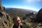
Amazing up here! It was a bit windy, but we were easily able to shelter in the large cairn at the top and still enjoy the 360 views. We spent just under an hour having our lunch and enjoying the views before heading back down via Lake Nicholls.
- View from the peak!
- View from the peak!
The track down to the hut on Lake Nicholls was quite rocky and steep, along with snow patches, which resulted in us being grateful we had our walking poles with us. At this stage I was starting to feel my knees and ankles. Arrived at the hut and had a quick stop, filled up the water bottle and then kept heading up the track.
- Track down to Nicholls Lake Hut
At this point the track became slightly easier (less rocks and more flat ground), however you still couldn't sprint. As we got close to the main road, there was an obvious track off to the right that cuts out a significant portion of the main road walking required to get back to the car park. I'd been keeping an eye out for this track, as I had found notes about it although it isn't marked on the 1:50 000 tasmap or the walking book we have. We accidentally took a track that went to Beatties Tarn - which thankfully wasn't too far! The (part) Old Pack Track, that cuts out a good portion of the main road walking, is sign posted and easy to find.
- Obvious sign keeping you off the main road
This part of the walk is by far the easiest to walk of the whole trip and was a relief not to have too much road-walking back to the car. It has a bit of a rain forest feel to it, with moss and fungus to admire if you have time. This track comes out on the main road, but if you walk up the road a short distance the track then continues through the forest, cutting out another main road bend. The second part of this track (also sign posted - although the sign is not viewable from the main road) was also excellent - a huge boulder field that you walk past rather than over.
- On the home straight
It's then just a relatively short walk up the main road to the car park - we arrived at about 5pm. So all up it took us about 6 hours (with an hour for lunch).
We both really enjoyed this walk. The distance and elevation were no problem, however the constant footing concentration required would push it up to a 'moderate' level walk. My partner wished he'd worn gaiters for the scratchy undergrowth and to avoid snow in the boots (I had long trousers, so wasn't such an issue for me). We had considered taking the track anti-clockwise, however were happy we chose the way we did; the steep track between Mt Field and Nicholls Lake Hut would not have been fun to walk up!