This walk represented a couple of significant things for me, firstly it was my proper first overnight solo walk and secondly it was my first solo off track walk. As it turned out I chose nice easy terrain to navigate and at no stage was I concerned about achieving my objectives
My day started around 10:30am when I picked up a couple of hitch hikers from the turn off at Deloraine who were standing on the side of the road with well loaded packs. I never pick up hitch hikers but it was obvious they were like minded people. One was a landscaper from Sydney who has far more walking experience in Tassie than me and the other was his friend from Sweden. I dropped them off at the turn off towards Devils Gullet/Lake Mackenzie as they were heading up to the Walls and walking out via Lake St Clair
My hardest navigational challenge started as soon as I got to the Dam wall as I didn't know where the track started! So I followed the map and within a few minutes I soon found the pad.

One thing about this trip was that I ended up doing my share of rock hopping. Mainly due to my choice of direction but there are certainly some rock fields in the area.

I wasnt long into the walk when I realised I was no longer on the pad and as it turned out I managed to head fisher river instead of the eastern side of explorer creek! I wasn't expecting to bush bash so early in the walk but thats what I had to do to make my way up to the proper pad.

I took some pics of the plantation..as you do


And it wasn't long before I had to cross explorer creek


And I arrived at Lake Explorer and had some lunch. The westerly wind was quite fresh.


I then had no real pad to follow but I went around the northern side of Snake Lake and picked up the Higgs track to Ironstone Hut.


Just as the Hut came into view it started to rain. I was lucky enough that it just held off enough so I didn't have to put my rain jacket on.


And what a beautiful little hut it is.

I spent some time reading some entries in the log book, having a cup of soup and generally exploring the hut. It was still only around 2:30pm but the rain was well and truly starting to set in so I made the decision that I wouldn't head around Forty Peaks today and camp at the lakes on the other side, instead I would stay in the hut.


Ok so thats enough hut pics...almost
The hut was quite warm considering it was pretty fresh outside. I went to bed very early and thanks to a possum who insisted on jumping on the tin lid on the wood box I didn't sleep consistently. However the next morning the sun rose to what was going to be beautiful blue skies.


Im now done with the hut pics I promise
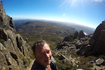
So I headed off quite early to try and find my way across to Middle Lake. I started by walking over the northern side of Forty Peaks to get a view of the lakes ahead of me.


Once down at the lakes I walked between Lake Chambers and Johnny Lake and made a note of the perfect camp sites around the edges. Nice grassy areas that could hold dozens of tents if not hundreds! However the westerly was blowing quite hard and it was sleeting so I was happy to have spent the night in the cosy hut.


So far the navigation was very easy and the terrain although quite wet from the rains the day/night before and the general lay of the land, it was reasonably easy and open.


There are 100's of little lakes and tarns in area and the flowing water is plentiful. I eventually arrived at Fisher river and after walking down it a bit to find a spot to cross without getting my feet too wet I negotiated my way over a little rise and back down to finally see Middle Lake. This little stretch, even though still very easy, was the thickest scrub so far. Discounting my little error at the start of the walk where I had to bash my way from fisher to the other side of explorer creek.


Once I was down at Middle Lake it looked like there were a couple of abandoned packs. On closer inspection there were also two pairs of boots and some clothes hanging up. I had a little look around the area but couldn't see anyone so I can only assume they were hiding somewhere fishing.

Once at Middle Lake it was easy enough to pick up on the pad that is Blue Peaks Track and walk back out.


It was a pleasant little walk. No real elevation changes and the whole area is easy to navigate and walk around. I saw a lot of snakes and had a fall after a snake decided to appear under my foot whilst I was mid stride
The gps said it was around 24 klm's but the gps software at home said it was around 21 so somewhere around there.
Here are a couple of data pics.