Trip Report- Bathurst Harbour to Lake Pedder

Trip reports, stories, track notes. Multiple/large photos are OK in this forum.
Forum rules
Posting large/multiple images in this forum is OK. Please start topic titles with the name of the location or track.

For topics focussed on photos rather than the trip, please consider posting in the 'Gallery' forum instead.

This forum is for posting information about trips you have done, not for requesting information about a track or area.

Trip Report- Bathurst Harbour to Lake Pedder

Postby backyard_botanist » Thu 08 Jan, 2015 8:53 pm

During Early December both myself and a mate were drop off by boat on the edge of Bathurst harbour a little west of Old River. Our target was Lake Pedder via Mt. Norold, the East and West Arthurs range, we had food for 18 days.
18.JPG

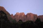
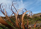
Our drop off point was a little stony beach approx. 1km west of Swan Cove, after enjoying clear views of the pristine Bathurst Harbour we headed up off the beach onto buttongrass plains following a ridgeline East toward Mt. Wilson (above image).
23.JPG

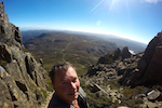
With 28kg packs and warm sun beating down on us, the going was sweaty but the view looking back at Bathurst harbour was well worth it (Above). From Mt. Wilson we proceeded across a saddle up onto the Mt. Norold Plateau, a shallow bowl approx. 8 km in circumference with a single lake and several waterfalls.
39.JPG

The most spectacular of the waterfalls was Abscida falls (Above), a multi-tiered waterfall separated by sharp shrubby drops.
48.JPG

Determined to experience the waterfalls we made our way down to the bottom of the third fall with some difficulty. After a day spent exploring the plateau we made our way down toward Old River via a series of ridge lines starting west of Richea peak. Thick cloud reduced visibility down to less than 50m making the going very difficult with much back tracking and head scratching as a result. Just as I thought we would wander in circles all day, the cloud lifted revealing the river several kilometres below us.
56.JPG

The view from a ridgeline looking west toward Old River and Bathurst Harbour.

Our going was frustrated by a thick slime mould that seemed to grow everywhere, making every second step a slippery effort to keep balance. We dubbed it South-west Slime (Although I would like a real name for it?).
64.JPG

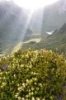
Incredible views coming down from the Mt. Norold Plateau.

Due to time lost back tracking in the cloud, we were racing the sun to cross Old River and make camp on Junction ridge. By the time we reached the river, the sun had gone down but the decision was made to make a night crossing.
With torch in mouth we dipped into the edge of the river following it upstream from the junction of the Solly River to a set of rapids. At times the depth of the river forced us to scramble across rocky ledges (the river side scrub was nasty in the dark). Once at the rapids we proceeded slowly in fast flowing, thigh deep water using exposed rocks to keep us upright, as we negotiated the 50m to the other side. I'm not sure I took a breath during the crossing.
Making camp on the Junction ridge, we were exuberant after our night time rapids crossing and were treated to a full moon. The sight of the moonlight reflecting of the quartzite rock of Harry's Bluff and the sound of the Solly and Old River merging is one I will never forget.
68.JPG

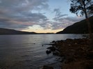
Looking west at the junction of the Solly and Old River.

From Junction ridge we made good going in fine weather through heath heading east toward George Ridge, slowed up by the occasional band of thick scrub (Melalueca sp., Ghania sp. and Bauera rubiodes). Camping the night on George we were visited by a curious Boo Book owl who kept as company for the night.
DSC_0031.JPG

Waking the next morning to another sunny day we got our first views of the Old River Valley and the major challenge of the hike..... Gorilla ridge upto Geeves Bluff (Above). The going across George ridge was generally good with exception of one band of thick scrub, once down onto the valley floor the going was made very easy due to relatively recent fire clearing our thick bands of scrub. Apart from almost stepping on a Ground Parrot and sighting a giant stonefly the going was rather uneventful. Before we knew it we were at the base of Gorilla ridge (or what we thought was Gorilla ridge) and the call was made to try for the Richea Plateau described by David Noble.
DSC_0089.JPG

Last minute campsite just below rocky cliffs W of Geeves Bluff.

Thus began what can only be described as an arduous and character testing ordeal. For the next two days we walked from sun up to sun down and covered only 4km!
We realized to late that we were not on Gorilla ridge but a ridge heading in a similar direction starting slightly NW. The scrub was thick, interlocked, covered in large fallen branches with scattered Ghania to cut up your hands and face, just because it wasn't trying enough already.

Much time was spent crawling on the ground squeezing packs under branches or climbing ontop of fallen branches with no idea where the ground was. The two nights we spent camped on the ridge were interesting to say the least..... Flat open space was non-existent (flat and scrubby or steep and somewhat open), so setting up a tent was not as option. We slept side by side under a tarp using our tent bases as a ground layer, the slope was such that u had to keep your legs tensed to avoid sliding down slope. Mosquitos and the occasional leech keep us company.

We often talked of the old school hikers of the 70's travelling up to fed peak via the Old River Valley and Gorilla ridge, much respect to those old chums.

The next morning we picked a way up very step cliffs onto a ridgeline, in drizzly rain and heavy cloud, with no visibility and unsure of where we had ascended, we weren't sure how far it was or in which direction Geeves Bluff and Hanging Lake (we had no GPS). Nothing to be done but wait out the weather and hope for a glimpse of a land mark.
DSC_0112.JPG

For a day and a half we waited on a cold windswept ridge, before a brief break in the cloud cover revealed Hanging lake just 400m to the East! Jubilant upon reaching the Lake we waited another day and a half in bad weather before the cloud broke and we got the views people so often rave about.....
User avatar
backyard_botanist
Nothofagus gunnii
Nothofagus gunnii
 
Posts: 25
Joined: Thu 04 Sep, 2014 6:54 pm
Region: Northern Territory
Gender: Male

Trip report- Bathurst Harbour to Lake Pedder (Part 2)

Postby backyard_botanist » Thu 08 Jan, 2015 9:28 pm

And we weren't disappointed :)
DSC_0231.JPG

Looking NW from Geeves Bluff, we believe the ridge located above my head is the false lead we followed up to Geeves Bluff (above).
DSC_0255.JPG

Our first look at Fed peak (Above).

As the cloud broke late in the day, the decision was made to make for the summit of Fed peak on the morrow. Waking to thick cloud didn't dampen our spirits. We had become accustomed to how quickly the weather can change, and sure enough after an hour or so the cloud broke revealing an absolute cracker of a day. It was on!
Accidently walking past the direct ascent we followed another route up (some climbing gear had been left in some sections), the going was generally not technical but their were several sections were you knew a slip or a bad choice of hand hold could result in a serious fall.
With adrenalin pumping we made the summit. The views combined with the adrenalin made for an incredible experience.
DSC_0421.JPG

View from the summit of Fed peak looking North with the Eastern Arthurs in the background.

Energised from summiting Fed peak we set off the Eastern Arthurs Track, which was in very good order with few false leads. Blessed with fine weather we made good time across Eastern Arthurs and Started up the Western, meeting our first people in 10 days at lake Rosanne.
The fine weather continued and we enjoyed full views of the Western Arthurs, again the tracks were generally clear and easy to follow, occasionally we spent a minute or two spread out until one of use picked up the track. A few areas are muddy and overused but given the difficulty of building and maintenance, full marks to Parks Tas.
DSC_0665.JPG

Looking West toward Mt Pegasus.
DSC_0683.JPG

Lake Oberon, the very warm weather inspired a short lived swim, even in 30+ degrees I could swim for longer than a few minutes.

At Lake Oberon we got word of a storm coming in, and decided to make for Lake Pedder the next day. ranges over the net few days. Hiking out we encountered heavy rain and thunder and were glad to be off the ranges, although a true SW Tassie storm would be something of an experience?
DSC_0811.JPG

Safely back at Lake Pedder, were exhausted but truly amazed and humbled by our first experience of the untouched expanse of SW Tassie.
User avatar
backyard_botanist
Nothofagus gunnii
Nothofagus gunnii
 
Posts: 25
Joined: Thu 04 Sep, 2014 6:54 pm
Region: Northern Territory
Gender: Male

Re: Trip report- Bathurst Harbour to Lake Pedder (Part 2)

Postby bumpingbill » Fri 09 Jan, 2015 8:03 am

Geez you got around. Nice read!

How many days in total? How long did it take you to get from Fedders to Oberon?
User avatar
bumpingbill
Athrotaxis cupressoides
 
Posts: 243
Joined: Tue 19 Feb, 2013 7:48 am
Region: Tasmania

Re: Trip report- Bathurst Harbour to Lake Pedder (Part 2)

Postby philm » Fri 09 Jan, 2015 11:48 am

Nice read guys and some excellent photos.
Well done on undertaking this one - looks magic.
User avatar
philm
Athrotaxis cupressoides
 
Posts: 477
Joined: Sat 06 Nov, 2010 10:49 am
Region: South Australia
Gender: Male

Re: Trip report- Bathurst Harbour to Lake Pedder (Part 2)

Postby backyard_botanist » Fri 09 Jan, 2015 5:58 pm

15 days in total, 4 days from Fed peak to Lake Pedder.
User avatar
backyard_botanist
Nothofagus gunnii
Nothofagus gunnii
 
Posts: 25
Joined: Thu 04 Sep, 2014 6:54 pm
Region: Northern Territory
Gender: Male

Re: Trip report- Bathurst Harbour to Lake Pedder (Part 2)

Postby stepbystep » Fri 09 Jan, 2015 8:26 pm

Excellent stuff guys. Thanks for the report, very refreshing to see "younger" people undertaking interesting historical routes like this, and your appreciation for the experience comes across. Thanks for posting this. The Norolds and Old River have been extensively discussed in my group, thanks for the inspiration :)

I'll put a request to the mods to merge your 2 parts so they stay together. Thanks again
The idea of wilderness needs no defense, it only needs defenders ~ Edward Abbey
User avatar
stepbystep
Lagarostrobos franklinii
 
Posts: 7707
Joined: Tue 19 May, 2009 10:19 am
Location: Street urchin
Region: Tasmania
Gender: Male

Re: Trip Report- Bathurst Harbour to Lake Pedder

Postby wildwalks » Sun 11 Jan, 2015 10:20 am

I just merged the two parts into one thread. Great adventure guys - thanks for sharing.

Matt :)
wildwalks
Magnus administratio
 
Posts: 949
Joined: Mon 22 Nov, 2010 4:35 pm
ASSOCIATED ORGANISATIONS: Wildwalks, Bushwalk.com & NPA NSW
Region: New South Wales
Gender: Male

Re: Trip Report- Bathurst Harbour to Lake Pedder

Postby GPSGuided » Sun 11 Jan, 2015 10:28 am

Epic! Thanks for the story telling. Great read.
Just move it!
User avatar
GPSGuided
Lagarostrobos franklinii
 
Posts: 6968
Joined: Mon 13 May, 2013 2:37 pm
Location: Sydney
Region: New South Wales

Re: Trip Report- Bathurst Harbour to Lake Pedder

Postby ofuros » Sun 11 Jan, 2015 11:53 am

Challenging adventure !....well done fellas.
Mountain views are good for my soul...& getting to them is good for my waistline !
https://ofuros.exposure.co/
User avatar
ofuros
Athrotaxis selaginoides
 
Posts: 1930
Joined: Fri 05 Feb, 2010 4:42 pm
Region: Queensland
Gender: Male

Re: Trip Report- Bathurst Harbour to Lake Pedder

Postby north-north-west » Sun 11 Jan, 2015 1:29 pm

Great stuff. Good on you for trying it.
"Mit der Dummheit kämpfen Götter selbst vergebens."
User avatar
north-north-west
Lagarostrobos franklinii
 
Posts: 15123
Joined: Thu 14 May, 2009 7:36 pm
Location: The Asylum
ASSOCIATED ORGANISATIONS: Social Misfits Anonymous
Region: Tasmania

Re: Trip Report- Bathurst Harbour to Lake Pedder

Postby dplanet » Sun 11 Jan, 2015 3:41 pm

Interesting reading guys. Surely, you had heard of Southwest Tassie weather conditions. Please pack a gps with you on this type of adventure. Cheers.
User avatar
dplanet
Phyllocladus aspleniifolius
 
Posts: 580
Joined: Thu 04 Oct, 2007 8:21 pm
Location: Ormond-Caulfield, Melbourne
Region: Victoria
Gender: Female

Re: Trip Report- Bathurst Harbour to Lake Pedder

Postby backyard_botanist » Sun 11 Jan, 2015 6:25 pm

While stuck on the ridge waiting for the thick cloud to clear we questioned why we didn't pack a GPS but doing things things in the old school style with just map and compass does add an extra element of adventure. Also learn't something about being patient :)
User avatar
backyard_botanist
Nothofagus gunnii
Nothofagus gunnii
 
Posts: 25
Joined: Thu 04 Sep, 2014 6:54 pm
Region: Northern Territory
Gender: Male

Re: Trip Report- Bathurst Harbour to Lake Pedder

Postby north-north-west » Sun 11 Jan, 2015 6:40 pm

dplanet wrote:Interesting reading guys. Surely, you had heard of Southwest Tassie weather conditions. Please pack a gps with you on this type of adventure. Cheers.

It's a classic route and the people who pioneered it and used it in the early days didn't use GPS. I doubt they had maps of the quality of our modern ones either.
"Mit der Dummheit kämpfen Götter selbst vergebens."
User avatar
north-north-west
Lagarostrobos franklinii
 
Posts: 15123
Joined: Thu 14 May, 2009 7:36 pm
Location: The Asylum
ASSOCIATED ORGANISATIONS: Social Misfits Anonymous
Region: Tasmania

Re: Trip Report- Bathurst Harbour to Lake Pedder

Postby dplanet » Sun 11 Jan, 2015 7:29 pm

Looking at the map, I can see the route you went. It was very straight forward (gps really not needed in fine weather). From where you were dropped off to the waterfalls, crossed the Old River, then headed east to F_Peak. It was about 15 kms from the Old River. From the F_Peak, follow the east and then the west.
User avatar
dplanet
Phyllocladus aspleniifolius
 
Posts: 580
Joined: Thu 04 Oct, 2007 8:21 pm
Location: Ormond-Caulfield, Melbourne
Region: Victoria
Gender: Female

Re: Trip Report- Bathurst Harbour to Lake Pedder

Postby Walk_fat boy_walk » Mon 12 Jan, 2015 2:18 pm

Cool report... sounds like a bit of an epic.

dplanet wrote:Surely, you had heard of Southwest Tassie weather conditions.


You presume that they underestimated the weather? Can't say I took that out of the report.
Walk_fat boy_walk
Lagarostrobos franklinii
 
Posts: 2091
Joined: Sat 21 Nov, 2009 6:59 am
Gender: Male

Re: Trip Report- Bathurst Harbour to Lake Pedder

Postby dplanet » Mon 12 Jan, 2015 4:48 pm

... probably crazy like me.
User avatar
dplanet
Phyllocladus aspleniifolius
 
Posts: 580
Joined: Thu 04 Oct, 2007 8:21 pm
Location: Ormond-Caulfield, Melbourne
Region: Victoria
Gender: Female

Re: Trip Report- Bathurst Harbour to Lake Pedder

Postby naturelover » Tue 13 Jan, 2015 3:11 pm

"Much time was spent crawling on the ground squeezing packs under branches or climbing ontop of fallen branches with no idea where the ground was. The two nights we spent camped on the ridge were interesting to say the least..... Flat open space was non-existent (flat and scrubby or steep and somewhat open), so setting up a tent was not as option. We slept side by side under a tarp using our tent bases as a ground layer, the slope was such that u had to keep your legs tensed to avoid sliding down slope. Mosquitos and the occasional leech keep us company."
Love it. For me, experiences like that heighten the pleasure of the wonderful views and the memories of the expedition. Good on you. Epic stuff
User avatar
naturelover
Athrotaxis cupressoides
 
Posts: 291
Joined: Mon 23 Apr, 2012 7:07 pm
Region: Tasmania
Gender: Female

Re: Trip report- Bathurst Harbour to Lake Pedder (Part 2)

Postby Snowzone » Tue 13 Jan, 2015 3:43 pm

backyard_botanist wrote:15 days in total, 4 days from Fed peak to Lake Pedder.

Geez, 4 days across the W Arthurs is a pretty big effort in itself let alone the first part of the trip. Well done! Great trip report, thanks for sharing.
User avatar
Snowzone
Phyllocladus aspleniifolius
 
Posts: 533
Joined: Sat 11 Dec, 2010 12:10 pm
Region: Victoria
Gender: Female

Re: Trip Report- Bathurst Harbour to Lake Pedder

Postby dplanet » Tue 13 Jan, 2015 4:11 pm

dplanet wrote:... probably "crazy" like me.
User avatar
dplanet
Phyllocladus aspleniifolius
 
Posts: 580
Joined: Thu 04 Oct, 2007 8:21 pm
Location: Ormond-Caulfield, Melbourne
Region: Victoria
Gender: Female

Re: Trip Report- Bathurst Harbour to Lake Pedder

Postby DanShell » Tue 13 Jan, 2015 5:03 pm

Wow just wow. Thanks for sharing
User avatar
DanShell
Athrotaxis selaginoides
 
Posts: 1261
Joined: Mon 18 Mar, 2013 11:23 am
Location: Central
Region: Tasmania
Gender: Male

Re: Trip Report- Bathurst Harbour to Lake Pedder

Postby backyard_botanist » Tue 13 Jan, 2015 5:04 pm

naturelover wrote:"Much time was spent crawling on the ground squeezing packs under branches or climbing ontop of fallen branches with no idea where the ground was. The two nights we spent camped on the ridge were interesting to say the least..... Flat open space was non-existent (flat and scrubby or steep and somewhat open), so setting up a tent was not as option. We slept side by side under a tarp using our tent bases as a ground layer, the slope was such that u had to keep your legs tensed to avoid sliding down slope. Mosquitos and the occasional leech keep us company."
Love it. For me, experiences like that heighten the pleasure of the wonderful views and the memories of the expedition. Good on you. Epic stuff


Couldn't agree more, getting to Hanging Lake and experiencing the views was our main source of motivation for pushing through the thick stuff. Then we reached the top and were confronted by thick cloud for a couple of days. SW Tassie really made us work physically and mentally for the views but like u say it only heightened the pleasure when the cloud cleared :D
User avatar
backyard_botanist
Nothofagus gunnii
Nothofagus gunnii
 
Posts: 25
Joined: Thu 04 Sep, 2014 6:54 pm
Region: Northern Territory
Gender: Male

Re: Trip Report- Bathurst Harbour to Lake Pedder

Postby tibboh » Tue 13 Jan, 2015 7:34 pm

What an adventure, thanks for sharing.
"I'd rather be up a mountain"
User avatar
tibboh
Athrotaxis selaginoides
 
Posts: 1306
Joined: Sat 26 Jan, 2013 3:54 pm
Region: Tasmania
Gender: Male

Re: Trip Report- Bathurst Harbour to Lake Pedder

Postby tasmaniac » Wed 14 Jan, 2015 2:11 pm

Great work! Thanks for sharing this epic adventure. Was it really your first experience in the South-West? You don't mind jumping in at the deep end.
tasmaniac
Athrotaxis cupressoides
 
Posts: 117
Joined: Thu 11 Sep, 2008 12:42 pm
Region: Tasmania

Re: Trip Report- Bathurst Harbour to Lake Pedder

Postby Eljimberino » Wed 14 Jan, 2015 5:12 pm

Awesome.


Ride On
Eljimberino
Athrotaxis cupressoides
 
Posts: 331
Joined: Wed 02 Jul, 2014 7:39 pm
Region: Western Australia

Re: Trip Report- Bathurst Harbour to Lake Pedder

Postby South_Aussie_Hiker » Thu 15 Jan, 2015 7:32 am

It certainly is good to see young people out doing things like this.

Well done.
User avatar
South_Aussie_Hiker
Phyllocladus aspleniifolius
 
Posts: 930
Joined: Tue 22 Feb, 2011 9:24 pm
Region: South Australia
Gender: Male

Re: Trip Report- Bathurst Harbour to Lake Pedder

Postby Eljimberino » Thu 15 Jan, 2015 5:42 pm

Using the internet, you mean?


Ride On
Eljimberino
Athrotaxis cupressoides
 
Posts: 331
Joined: Wed 02 Jul, 2014 7:39 pm
Region: Western Australia


Return to TAS Trip Reports & Track Notes

Who is online

Users browsing this forum: No registered users and 13 guests