Lakes Bill, Myrtle, Meston, Junction, Chapter Walk

Trip reports, stories, track notes. Multiple/large photos are OK in this forum.
Forum rules
Posting large/multiple images in this forum is OK. Please start topic titles with the name of the location or track.

For topics focussed on photos rather than the trip, please consider posting in the 'Gallery' forum instead.

This forum is for posting information about trips you have done, not for requesting information about a track or area.

Lakes Bill, Myrtle, Meston, Junction, Chapter Walk

Postby DanShell » Mon 22 Dec, 2014 9:56 am

On advice on here from a nice member we wanted to do a little loop in this area so we chose to walk in via Lake Bill, stay the night at Junction Lake and walk out via Chapter Lake.

We are lucky enough to live in the general area so we were at the start of the walk in the Mersey Valley at 9 am, where we were greeted with some drizzly rain. Which was expected on Day one.

We signed the Lake Bill Log book and managed to cover ourselves in Leeches going up the steep little pinch to the top. Interestingly only about 10 minutes into the walk we managed to lose the track in the very overgrown ferns, but found it again easily enough.

Image

Image

Image

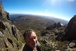
Once up the top the rain had stopped, the sun was coming out and it was turning out to be a nice day. We removed at least 20 leaches each off ourselves, put some mozzie repellent on as we were now getting eaten alive by them and set off towards Lake Bill.

Image

Yours Truly, the fat old fart as my little mate likes to call me :(
Image

And my young mate who is new to this business...so young yet knows so much ;)
Image

And Lake bill quickly comes into sight.
Image

Image

A nice little creek crossing...which I am very cautious not to fall into and its time to find a nice spot for some lunch.
Image

Image

Sometimes there is just no glamorous way to get across wobbly logs crossing a stream.

Image

And soon enough Lake Myrtle comes up. There are some nice spots to camp around here but the track is difficult to find to continue on. Id suggest people get some GPS data or some way to find the track here.
Image

Then its the nice walk down to Lake Meston and the Hut.
Image

Image

Image

Image

We had a nice rest stop at the hut, which is full of rubbish disappointingly (too much crap in it for us to get it all out). It was still early enough in the day so we made our way towards Junction Lake Hut.

We didn't have enough time to find our way to the top of Mount Ragoona and to be honest Im not sure either of us were physically up to it at this stage of the day.
Image

A giant that has crashed down.
Image

Mayfields Flats.
Image

And finally Junction Lake Hut where we spent the night.
Image

There is some lovely water flowing right past the hut, although we still filtered it because surprisingly there was old remnants of toilet paper around the Hut! I find it odd that people who are willing to go to the trouble it takes to get to hut like this don't understand the 100 mtr from water rule and dig a hole.
The Hut itself is a lot less used than Meston and quite clean. We had some nice liquid refreshments and a not so nice meal and we both managed to get quite a bit of sleep.

Day 2 to follow......
Last edited by DanShell on Mon 22 Dec, 2014 11:00 pm, edited 2 times in total.
User avatar
DanShell
Athrotaxis selaginoides
 
Posts: 1261
Joined: Mon 18 Mar, 2013 11:23 am
Location: Central
Region: Tasmania
Gender: Male

Re: Lakes Bill, Myrtle, Meston, Junction, Chaptor Walk

Postby DanShell » Mon 22 Dec, 2014 10:43 am

The next morning we had a lazy start, which wasn't planned but I think our bodies must have need the extra rest. Day one was over 18 kays and not always on easy to walk on terrain.

The sun was shining and after breakfast we were ready to tackle what we knew may be some navigational challenges.

Image

Junction Lake
Image

The first little challenge that presented itself was finding our way to Choister Lagoon. There was no real pad but usually there was a well placed stick or a rock cairn giving an indication that we were on the right track so to speak. We tried our best to add to the markers to help others out.

Image

Image

Another giant that has fallen.

Image

It was through here that things got really interesting. We knew we were heading the right direction but we couldn't find a pad or any indication of being on the right track at all. After stumbling around in the thick ground cover (sorry I need to research the vegetation of Tas more as I am sure I am missing some significant plants because of my lack of knowledge) and scratching ourselves up we decided we would head towards a little creek which we knew ran into Choister Lagoon and by shear chance stumbled onto the well trodden track!
Image

It was a pleasant walk through the rain forest.
Image

A bit thick at times.
Image

We then made our way past Choister and again continually lost the track as we went through some 'smaller' unnamed tarns.
Image

Image

Image

Image

At one stage we must have bashed our way around thick scrub for close to an hour. It was hot, steep and hard work. We kept finding tell tail signs that we were in the right area so we kept heading towards Chapter Lake. Things like a persons sun glasses, broken branches etc lured us to a dead end of a shear rock face and the edge of a deep tarn!

We had no choice but to back track and find our way up over the rock face.

Image

Image

Image

Once we got up onto the 'escarpment' we found the proper track, much to our relief. But that little off track excursion was exhausting.

From then on the walk was really scenic, sheltered and quite a nice way to end the day. We easily went past Grace Falls and Chapter Lake and made our way back to the road.

Image

Image

Image

Image

Image

Image

Image

Image

Image

Image

Once we were back to the road we had the horrible 4 or so klm walk back to the car LOL

It was a challenging walk for us both being reasonably new to hiking but also rewarding. We learnt a couple of valuable lessons in navigation. One being that as soon as you know you have left or lost the pad, go back to the last known marker and look harder! The next being, make sure you have all your maps, compass, gps, gps data etc of the area it was all so valuable to us finding our way when we lost the track.

Heres a little bit of data incase anyones interested. Sorry for the size.

Image

Image
User avatar
DanShell
Athrotaxis selaginoides
 
Posts: 1261
Joined: Mon 18 Mar, 2013 11:23 am
Location: Central
Region: Tasmania
Gender: Male

Re: Lakes Bill, Myrtle, Meston, Junction, Chaptor Walk

Postby north-north-west » Mon 22 Dec, 2014 2:10 pm

Nice. Glad you made it back in one piece.
Only bit of this I had trouble with was immediately north of Junction. Once I got onto the right ridge it was fine. That was a few years ago however, and I don't think that part of the track/route gets any maintenance.

As for the way forward from Lake Myrtle, has someone removed the golf umbrella? One of Tozzie's more original track markers.
Attachments
c-16088c.jpg
"Mit der Dummheit kämpfen Götter selbst vergebens."
User avatar
north-north-west
Lagarostrobos franklinii
 
Posts: 15143
Joined: Thu 14 May, 2009 7:36 pm
Location: The Asylum
ASSOCIATED ORGANISATIONS: Social Misfits Anonymous
Region: Tasmania

Re: Lakes Bill, Myrtle, Meston, Junction, Chapter Walk

Postby DanShell » Tue 23 Dec, 2014 7:45 am

Thanks very much for replying.

The track between Junction and Chapter lake is really overgrown in places and in quite a few instances there is no pad at all, only sticks and cairns etc as markers.

I am pleased we were able to walk when we have. We didn't see the umbrella but there was an old tin and few food wrappers as markers!

Once again thanks for the advice. I don't suppose you can tell me of some other 2 to 3 day walks that go in a loop and don't back track a lot to get back to car?? :mrgreen:
User avatar
DanShell
Athrotaxis selaginoides
 
Posts: 1261
Joined: Mon 18 Mar, 2013 11:23 am
Location: Central
Region: Tasmania
Gender: Male

Re: Lakes Bill, Myrtle, Meston, Junction, Chapter Walk

Postby philm » Tue 23 Dec, 2014 7:47 am

Great trip report and love the photo's - looks like you had some good weather.
Disappointing to hear that Meston Hut was full of rubbish. Junction Hut is in a great spot.
A really nice trip from Junction is to go onto Lake Artemis and camp in a finger that protrudes into the lake. It is only about another 2 hours further on and the track is reasonably easy to follow.
Do you have a GPS track of the walk from Junction out to the Mersey forest road as we are planning to do this walk and sound like some directions would be handy!
User avatar
philm
Athrotaxis cupressoides
 
Posts: 477
Joined: Sat 06 Nov, 2010 10:49 am
Region: South Australia
Gender: Male

Re: Lakes Bill, Myrtle, Meston, Junction, Chapter Walk

Postby DanShell » Tue 23 Dec, 2014 8:09 am

philm wrote:Great trip report and love the photo's - looks like you had some good weather.
Disappointing to hear that Meston Hut was full of rubbish. Junction Hut is in a great spot.
A really nice trip from Junction is to go onto Lake Artemis and camp in a finger that protrudes into the lake. It is only about another 2 hours further on and the track is reasonably easy to follow.
Do you have a GPS track of the walk from Junction out to the Mersey forest road as we are planning to do this walk and sound like some directions would be handy!


Hi Philm
Thanks for the advice.
Yes I do have the gps data if you PM me your email Ill send it. But as the report suggested there were a couple of spots where we wandered around the bush for a while so I wouldn't follow exactly in our foot steps but if you have a good look at the data its obvious where we were searching for the track so it shouldn't be too difficult to be very vigilant in that area!
In fact Ill put a way point at the two spots where we bush bashed and found the track again so you can't do the same thing :)
User avatar
DanShell
Athrotaxis selaginoides
 
Posts: 1261
Joined: Mon 18 Mar, 2013 11:23 am
Location: Central
Region: Tasmania
Gender: Male

Re: Lakes Bill, Myrtle, Meston, Junction, Chapter Walk

Postby north-north-west » Tue 23 Dec, 2014 2:28 pm

DanShell wrote:I don't suppose you can tell me of some other 2 to 3 day walks that go in a loop and don't back track a lot to get back to car?? :mrgreen:

Not if you insist on staying on track. It's easy to make it up as you go on the Central Plateau, but loops mostly mean off-track walking. Have a look at the Lake MacKenzie map and the section immediately south of that. It should be possible to do something there with minimal backtracking and in good weather the cross country stuff is very, very easy. Ironstone & Bastion Bluff, Forty Lakes Peak, Blue Peaks, that area.

Again, Ben Lomond has some very good off-track walking with dead easy navigation in good weather. You can follow the Little Hell snow poles and keep going south to Lake Youl, which is a great spot to camp, do a bit of exploration there and follow a different line back - even going over Allan Heights and Ossians Throne. Or head out to Menamatta Tarns from Legges Tor/Giblin Peak and explore Magnet and Coalmine Crags, north to Old Bills Monument, and pick up the Carr Villa track on the way back.
"Mit der Dummheit kämpfen Götter selbst vergebens."
User avatar
north-north-west
Lagarostrobos franklinii
 
Posts: 15143
Joined: Thu 14 May, 2009 7:36 pm
Location: The Asylum
ASSOCIATED ORGANISATIONS: Social Misfits Anonymous
Region: Tasmania

Re: Lakes Bill, Myrtle, Meston, Junction, Chapter Walk

Postby DanShell » Wed 24 Dec, 2014 5:23 pm

north-north-west wrote:
DanShell wrote:I don't suppose you can tell me of some other 2 to 3 day walks that go in a loop and don't back track a lot to get back to car?? :mrgreen:

Not if you insist on staying on track. It's easy to make it up as you go on the Central Plateau, but loops mostly mean off-track walking. Have a look at the Lake MacKenzie map and the section immediately south of that. It should be possible to do something there with minimal backtracking and in good weather the cross country stuff is very, very easy. Ironstone & Bastion Bluff, Forty Lakes Peak, Blue Peaks, that area.

Again, Ben Lomond has some very good off-track walking with dead easy navigation in good weather. You can follow the Little Hell snow poles and keep going south to Lake Youl, which is a great spot to camp, do a bit of exploration there and follow a different line back - even going over Allan Heights and Ossians Throne. Or head out to Menamatta Tarns from Legges Tor/Giblin Peak and explore Magnet and Coalmine Crags, north to Old Bills Monument, and pick up the Carr Villa track on the way back.


Can I get from Lake Explorer, across to Middle Lake easy enough? Have you walked that section? PM me if we are not within the forums rules. Sorry to be a pain but I really do appreciate your experience, as I gain more experience Ill most like just walk into these areas and 'try' them out for myself!
User avatar
DanShell
Athrotaxis selaginoides
 
Posts: 1261
Joined: Mon 18 Mar, 2013 11:23 am
Location: Central
Region: Tasmania
Gender: Male

Re: Lakes Bill, Myrtle, Meston, Junction, Chapter Walk

Postby north-north-west » Wed 24 Dec, 2014 6:13 pm

You mean to connect the two tracks? Yeah, I did that - not that I was on track more than a few hundred metres - and found the navigation pretty easy, even when the weather clagged up a bit. You have to dodge around some of the water bodies, but it's mostly common sense. If you managed to follow Moses Creek when it's badly overgrown I can't see why you couldn't manage that bit.

This is part of that walk. I actually started at Lake Augusta and went in over Wild Dog, via Bastion and Ironstone. The scoparia is usually great this time of year. It wanders a lot because I tend to wander a lot when I'm in ramble mode. There's a little bit of scrub around Turanna Bluff but mostly it's very open.
The loop on the right is Bastion & Ironstone, the long, skinny kinky one on the top left would be Fisher Bluff, and the lower one Mersey Crag (which has a little bit of scrub but there is a pad).
Attachments
CentralPlateau2.jpg
"Mit der Dummheit kämpfen Götter selbst vergebens."
User avatar
north-north-west
Lagarostrobos franklinii
 
Posts: 15143
Joined: Thu 14 May, 2009 7:36 pm
Location: The Asylum
ASSOCIATED ORGANISATIONS: Social Misfits Anonymous
Region: Tasmania

Re: Lakes Bill, Myrtle, Meston, Junction, Chapter Walk

Postby DanShell » Wed 24 Dec, 2014 9:46 pm

Thanks NNW. I am going to check it out in a couple of weeks :)

This question is possibly worth a thread on its own but I have to ask, do you ever get concerned about your off track walking in the context of getting into some sort of trouble?

As an example, it is late in the day your expected to return, you keep coming to too many obstacles to easily walk through so you have to walk around but you are physically exhausted so you need to spend the extra time (maybe the next day) to walk out. Ok so its not really being in trouble but its certainly a delay that may concern people who know your out there.

Is the thought process such that every one knows you can hit the button if your in real trouble so you will be home eventually or simply they know not to worry because you don't really have a time limit on some walks?

I thought I read somewhere on here that you like to walk alone, I can't imagine the mental strength it would take to tackle an unknown off track multi day hike with out someones gps data?

Sorry if my question seems like a silly one, but I am still learning and I am contemplating if I would be exhilarated or disappointed taking on some off track walks on my own! Im starting to think I like the idea of it. I certainly enjoy sharing the experience I get from being in the bush with others but the more I deal with people, the more I am liking my own company and a good book ;)
User avatar
DanShell
Athrotaxis selaginoides
 
Posts: 1261
Joined: Mon 18 Mar, 2013 11:23 am
Location: Central
Region: Tasmania
Gender: Male

Re: Lakes Bill, Myrtle, Meston, Junction, Chapter Walk

Postby north-north-west » Thu 25 Dec, 2014 6:14 am

There's nothing silly about the question, it's a perfectly reasonable & sensible one to ask.

Currently I'm living alone and too crazy to work so return dates aren't so much of an issue. When I was still on the mainland and working I tried as much as possible to give myself an extra day on the more iffy trips just in case, although there were a few times when I was caught out. Once I spent an unplanned night on a hillside after copping a migraine in the middle of the afternoon, once the car was trapped behind a massive treefall on the way out, once when I took a mate's kids for a snowcamp we all copped some sort of tummy upset - luckily that one was one the Bogong High Plains and I could get a message out. The boss knew I was a walker and was usually warned when I was going bush and told not to worry unless he didn't hear anything for a couple of days. But I never really worried about it.

I carry a PLB and a GPS which, for the longer and more 'interesting' trips down here, will most likely be loaded with either a pre-determined route or (when I'm very lucky, like the Manfred loop) a GPX file from someone who has completed it, although using the GPS for navigation is strictly a last resort. I've only ever done so half a dozen times - finding my way down through the cliffs on the eastern side of Manfred, for instance.
But that Central Plateau walk I didn't even have the high points logged, just went on the good old 'make it up as you go along' method. Map, compass and common sense cover a multitude of sins.

Experience is the big thing. I've done a lot of solo technical diving, covered a lot of distance walking. There are ways of developing knowledge of an area bit by bit and extending that to areas you haven't yet been into. You get used to it, and I like the challenge of finding my own way out there. You work your way up to it slowly, develop an understanding of what's involved, push your boundaries a teensy little bit further every time.
I take fewer risks now, especially with climbing, and I'm less likely to go out unless the weather is reasonable. Something's woken me up to the possibility of coming unstuck and I'd rather not submit someone else to the unpleasant experience of finding my decayed body out there. But it isn't going to stop me.

Far as mental strength is concerned, it takes more to put up with having someone else around, particularly out bush. :wink:
"Mit der Dummheit kämpfen Götter selbst vergebens."
User avatar
north-north-west
Lagarostrobos franklinii
 
Posts: 15143
Joined: Thu 14 May, 2009 7:36 pm
Location: The Asylum
ASSOCIATED ORGANISATIONS: Social Misfits Anonymous
Region: Tasmania

Re: Lakes Bill, Myrtle, Meston, Junction, Chapter Walk

Postby DanShell » Thu 25 Dec, 2014 7:42 am

I use my GPS instead of my map and compass. Obviously I take a map and compass but I look at them as a safety item incase the GPS dies. Im thinking I probably should start doing it the other way around so I get better at using the compass.

Thanks again for your advice. I like the fact that you say "and too crazy to work" and I can relate to this statement "Far as mental strength is concerned, it takes more to put up with having someone else around, particularly out bush" especially when they are down and out LOL

Ill just keep easing myself into it more and more. Each walk I have done lately has had some off track sections so I am learning. Do you buy maps of an area or is there a way to print a detailed map from an online source? I usually just print them from the gov thelist site.

Merry Xmas :)
User avatar
DanShell
Athrotaxis selaginoides
 
Posts: 1261
Joined: Mon 18 Mar, 2013 11:23 am
Location: Central
Region: Tasmania
Gender: Male

Re: Lakes Bill, Myrtle, Meston, Junction, Chapter Walk

Postby north-north-west » Thu 25 Dec, 2014 9:07 am

I always used to buy maps and have a massive collection, covering most of the Australian Alps as well as a good portion of Tassie; have most of the areas I'm planning to walk over the next couple of years covered. But the maps on TheList site are good enough - they have the TasMaps 1:25k as a basemap option and while it takes a bit of fiddling you can just print out the bit you need. Would have been nice to have known about that ten years ago when my collection was a tenth its current size.
It gets expensive after a while - even printing them yourself isn't dirt cheap - but I'm old school enough to prefer it for navigation. Besides, a paper map covers far more ground in far more detail than a GPS screen. No toggling up and down and side to side to try to see what comes next, it's all there in front of you. Keeps it all in context.

Tasmaps have released a digital version of the 1:25k series but it's overpriced and then you still have the expense of printing them. Set up properly TheList gives you the same detail, so you might as well stick with it.
"Mit der Dummheit kämpfen Götter selbst vergebens."
User avatar
north-north-west
Lagarostrobos franklinii
 
Posts: 15143
Joined: Thu 14 May, 2009 7:36 pm
Location: The Asylum
ASSOCIATED ORGANISATIONS: Social Misfits Anonymous
Region: Tasmania


Return to TAS Trip Reports & Track Notes

Who is online

Users browsing this forum: No registered users and 13 guests